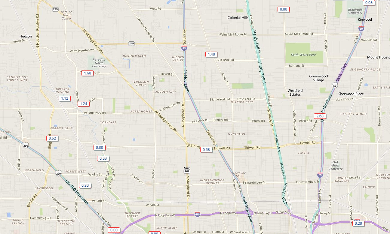
The Houston area has had an interesting couple of days. I think Eric and I have both been surprised by the intensity of some of the sea breeze storms that have fired the last two days. Yesterday saw areas north of Downtown get hammered, with US-59 between Tidwell and Little York especially hard hit by over two and a half inches of rain.
So as we go into the weekend, shall we expect more?
Today
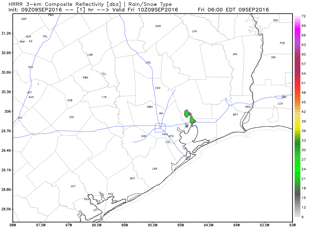
We’re already seeing a few showers this morning, mainly in Northeast Harris and Liberty Counties.
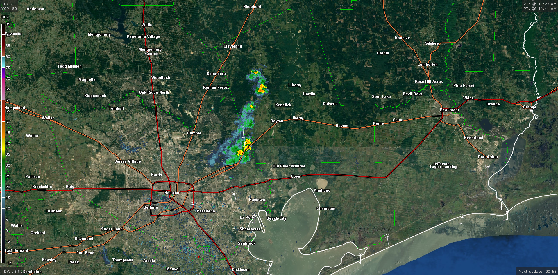
As we head into this afternoon, storms may be a bit more numerous compared to the last couple days, but that won’t mean that everyone sees rain. As is usually the case, sporadic downpours will be capable of producing 1-3″ of rain in a few spots this afternoon. I suspect a good bunch of the area will not see showers though. So it’s a game of luck today, with the most favored areas initially being east of I-45 and south of US-59 as you head southwest of Houston, then spreading north and west.
Temperatures have struck the mid 90s before rain the last few days. We may do that again today, but I’m guessing that with showers getting an earlier start, low 90s may be the best we can do.
Weekend
Our weekend will be influenced by tropical moisture in off the Gulf of Mexico mixing it up with an approaching cold front. The front by Sunday morning gets through about Waco before slamming on the brakes.
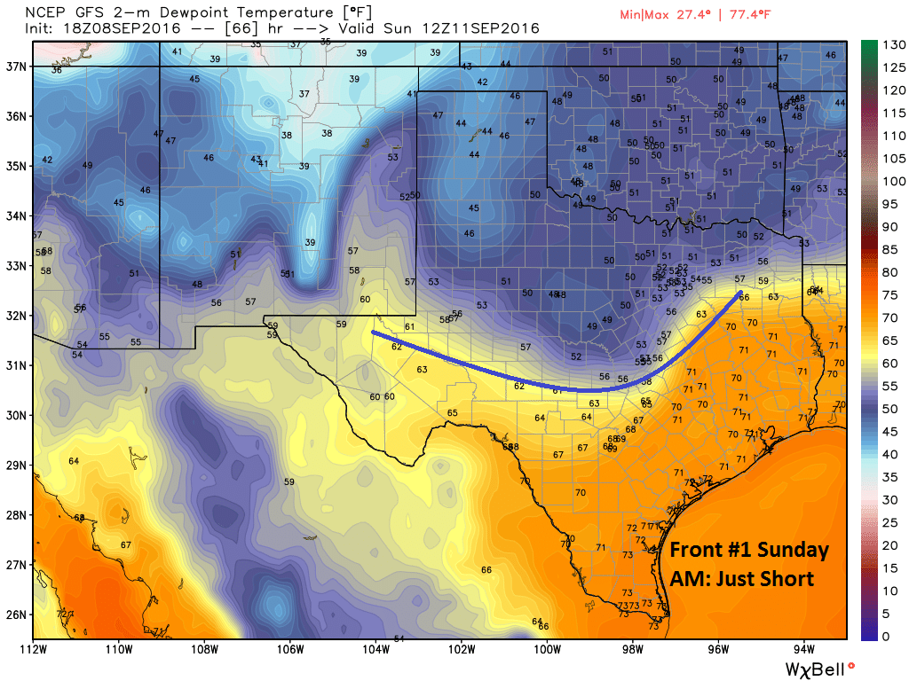
Because the front is in the neighborhood, so to speak, it will help to provide enough “lift” in the atmosphere to combine with the tropical moisture moving inland from the Gulf to produce numerous showers and storms Saturday and Sunday afternoons. I don’t think either day will be a washout, but you’re going to have to deal with showers and storms in the area on both days. If your travel plans take you anywhere in East or Central Texas, this will be the case. So if you’re going to see UH battle it out versus Lamar or headed up to College Station for Texas A&M vs. Prairie View A&M, don’t be shocked if you have a downpour or some lightning in the area to deal with. Oh, and I think we can safely pronounce that the roof will be closed for the Texans vs. Bears on Sunday.
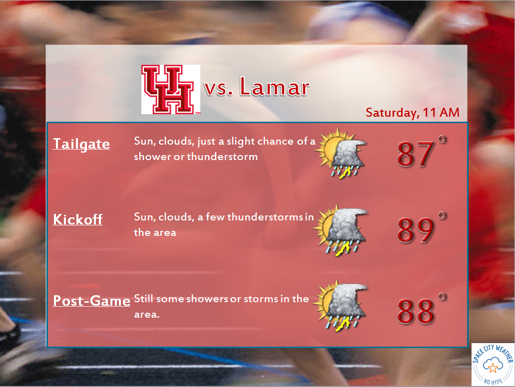
Temperatures will be held back a bit with showers around, but I still expect us to peak near 90 on both weekend days.
Next Week
As of now, it looks to stay fairly active next week, with showers and storms around Houston each afternoon. The European model in particular is pretty aggressive in bringing a surge of tropical moisture in around mid-week that would help produce a good amount of storms each day. And with another front trying to push into the state, as Eric discussed yesterday, that may help provide further fuel for showers and storms. At this point, it’s too early to say much specifically, but I would expect “Storm o’clock” to continue to arrive each day over the next week or so.
Tropics
The tropics, as they relate to our neck of the woods, are rather quiet. There are 2 disturbances marked on the NHC map below. In yellow, Invest 93L and in orange Invest 94L.
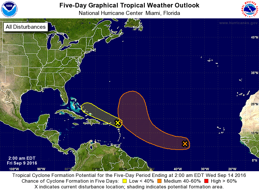
From the map alone, you can see the favored tracks of both systems likely would avoid Texas. With fronts trying to drop into the state now, the weather pattern just doesn’t favor anything organized getting to the Western Gulf. The Atlantic tropics look active for the next 7-10 days or so, but all reliable modeling and meteorology suggests the Gulf should be fairly quiet. As always, we’ll continue watching!
As usual Matt you and Eric provide great, easy to understand info…as far as the roof at NRG…they might as well weld it shut! Will look forward to Texan tailgating update as we get closer…then keep tropical storms away…thanks!
Cold front….cold front….cold front…. (keep chanting) .. cold front…
Red alert, matt and Eric! 92L has redeveloped and is located between the Florida Keys and Cuba. It has a 30%-40% chance to develop according to NHC. Areas from Mexico to Louisiana must monitor the progress of this system as it tracks westward across the Gulf.
NOTE: Possible Rita reincarnation!
Just stop it.
Worrybug is right, Eric. I doubt those cold fronts you’ve mentioned will come far enough south to keep 92L out of SE Texas, or anywhere else on the Texas coast. Bottom line: This could be the one we’ve been waiting for, folks! Be ready!