Good evening. We’re continuing to track the evolving forecast for a hard freeze in Houston, which has implications for the Houston Marathon on Sunday, the MLK Parade on Monday, and a host of other activities in Houston and beyond in the state of Texas. This post will update all of that, and well as provide a more holistic view of impacts to Texas. Be sure to read that section if you’re planning to be driving among the cities of Houston, Austin, Dallas, and Fort Worth on Monday.
How to follow us
Before jumping into the forecast, I want to provide a short summary of how to find and follow Space City Weather as the prospect of a freeze has brought us new readers.
EMAIL: If you want to get every post emailed to your inbox (without tracking or other extraneous nonsense) you can sign subscribe via email. (It’s free, and always will be). The box to input your email is either at the bottom of this page, on mobile, or on the right-hand side, on desktop.
APP: You can download our app (iOS version or the Android version). Both are free. You can read more about it here. Also, our use of “Houmidity” is not a bug!
SOCIALS: In terms of social media, we try to be wherever you are. Houston Chronicle tech columnist Dwight Silverman, who manages the development of our weather app, has expanded his role to help with social media so we can be on more platforms. Accordingly, SCW has now a presence on X (formerly known as Twitter), Facebook, Instagram, Threads, Mastodon and Bluesky.
The latest forecast
Not a whole lot has changed today, in comparison to what Matt wrote this morning. Today’s blustery winds will settle down this evening, and after a chilly night in the 30s we’ll see a very pleasant Saturday. Look for highs in the mid-60s with plenty of sunshine and light southerly winds. It’s a near ideal winter weekend day. Unfortunately, the pleasant weather will end soon thereafter.
Most of the model guidance is still bringing an Arctic front into Houston by around sunrise, plus or minus a few hours, on Sunday morning. This will be a cold day, likely with high temperatures in the upper 30s or lower 40s for most locations. If you’re running the Houston Marathon, I’ll have a full rundown of what to expect for race weather in Saturday morning’s post.
Most of the metro area should remain just above freezing on Sunday night, or experience a light freeze at most. But we start to have some concerns on Monday, a holiday for many in remembrance of Martin Luther King Jr. It will be a cold day, with highs likely in the upper 30s for most. That’s fine, but there is the threat of some light precipitation during the daytime hours. This is likely to fall as freezing rain north of Houston, perhaps in The Woodlands, or perhaps further north. I still don’t feel confident in saying how much of an impact this is going to have an roadways, especially if the rain stops while temperatures are still above freezing, and the winds help dry roads. But it could be factor Monday evening or Tuesday morning. We’ll see.
Monday night has been trending slightly warmer in some recent model runs, but I still think most of the area is going to fall below 25 degrees, with sub-20 degree temperatures possible for areas west of Houston (i.e. Katy) and north of Houston (i.e. The Woodlands). However this is something we’ll continue to monitor.
Tuesday is going to be sunny and cold, with highs perhaps around freezing, perhaps a degree or two above freezing. This will set the stage for ideal cooling on Tuesday night, with lows likely dropping into the low 20s in the urban core of Houston, with colder conditions for outlying areas. How cold? We’re just going to have to continue to monitor temperature trends. We warm up Wednesday and will be in the clear in regard to freezing temperatures.
Texas temperatures
Let’s step back and take a broader look at the state of Texas, as a whole. To begin with, I went back and pulled the record cold temperatures for Texas during the depth of the 2021 freeze, which occurred in mid-February.
| Amarillo | -11 degrees |
| Austin | 8 degrees |
| Corpus Christi | 17 degrees |
| Dallas | -2 degrees |
| El Paso | 14 degrees |
| Houston | 12 degrees |
| San Antonio | 9 degrees |
| Waco | -1 degree |
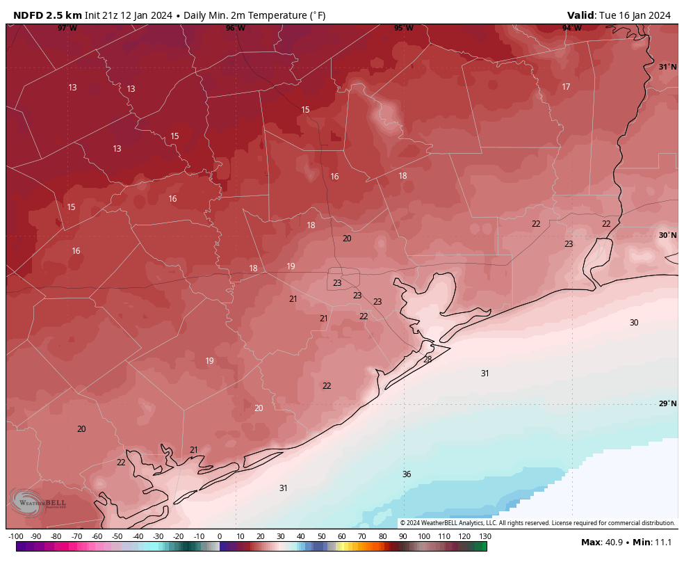
Next, let’s look at the current forecast for low temperatures next week. I’m showing the map for Tuesday, since that will be the coldest morning for the vast majority of the state. If you compare the record lows above, most locations will be solidly 5 to 10 degrees warmer than the cold snap.
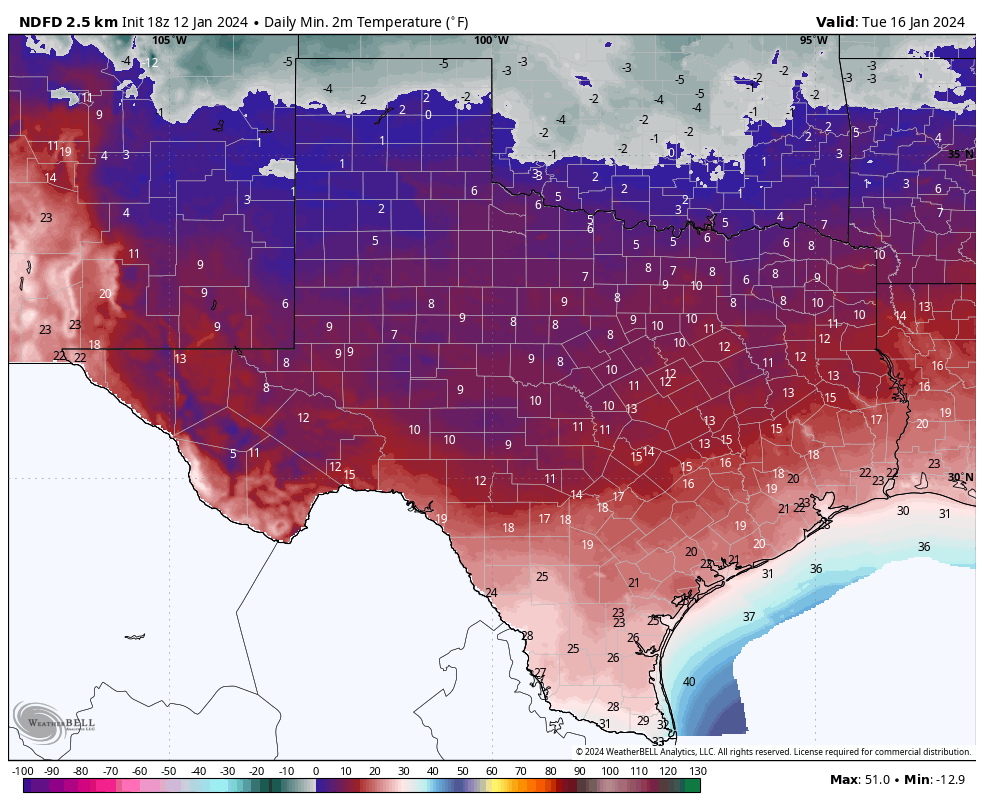
This is one reason why we have some (not total, to be sure) confidence that the statewide electricity grid will hold up next week. ERCOT, for its part, expects “normal” conditions next week in terms of grid performance.
Sleeting in the Lone Star State
Beyond the cold conditions, the other concern for statewide weather is the potential for wintry precipitation to muck up roadways. Atmospheric conditions do not favor snowfall in Texas—sorry kids. However there is likely to be some overrunning precipitation on Sunday night Monday across the eastern half of the state, meaning that there will be a layer of warmer and wetter air aloft, and this will allow for sleet or freezing rain to fall. Forecasting this kind of precipitation in Texas is always a challenge, so this is something of a hand-waving exercise. But in terms of timing there is a chance of some light, freezing rain from from roughly Austin to College Station to the northern Houston suburbs on Monday. Here is how the GFS model forecasts freezing rain early next week:
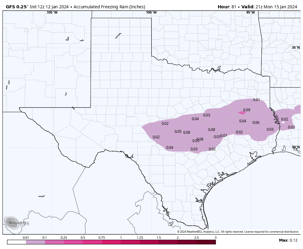
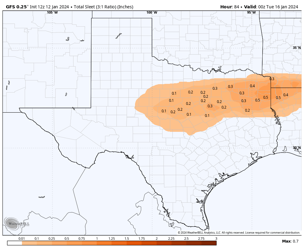
Somewhere along the way from Houston to Dallas, this freezing rain it is going to turn to sleet. There is a pretty simple reason for this. Freezing rain is very cold rain that freezes when it hits the ground. Sleet is rain that re-freezes before it reaches the ground, and is sometimes referred to as ice pellets. So as temperatures get colder near the surface, sleet becomes more likely. But it’s difficult to say where this turnover will occur. Accordingly, sleet or freezing rain will be possible on Sunday night and Monday in parts of north and East Texas, including the Dallas-Fort Worth area. The bottom line is that, if your plans call for travel between Houston, Dallas, and Austin on Monday, you should pay close attention to road conditions before setting out.
In summary, a serious cold spell is coming to Texas. The good news is that it will not be nearly as cold as 2021, nor last nearly as long. Our electricity grid and the power plants that supply it have also been winterized since then. There still could be problems, but I don’t expect them to be insane like three years ago.
We’ll be back with a comprehensive post on Saturday morning.


SCW is absolutely The Best.
Thank you for keeping us informed so we can be prepared.
Thank you very much for the continued updates y’all bring us. We avoid the local tv weather channels and other forms of media because y’all bring us the real deal. We have been following y’all for years and can’t thank y’all enough for real weather reports without all the hype and drama…..
Yall are the best!!!!!!!!!!!!!!!
My son and his GF will be heading back to college at UNT (north of Dallas). They want to leave from SE of Houston on Monday. I really want them to head out on Saturday to be safe but they want to stay down here thru Sunday. What are your thoughts for me to persuade then to leave on Sat? His GF has bridal shower to attend on Sunday afternoon and we don’t want them to drive the 4+ hours in the dark on Sunday evening.
Thank you Eric and Matt. Besides reading all SCW updates every day, I also monitor a Weather Underground PWS that is right nearby my house. There is a link from that page to an hourly forecast for Missouri City (I am in Sienna, zip code 77459). Per this WU forecast site, the predicted at or below freezing hours for Missouri City are from like 1:00 am Tuesday morning until about 10:30 am Wednesday morning. So like 33 to 34 hours in duration, and the coldest times right at sunrise Tuesday morning and Wednesday morning. As long as the lights stay on, we ought to be okay by following the guidelines provided.
Good luck everyone!
“Take it easy when shoveling” – gotta love it. Brings back memories of Canada! Always appreciate the updates.
“Take it easy when shoveling” – gotta love it! Thanks for the update as always.
So a basic cold weather non-event for Houston, gotcha.
I always love your no nonsense approach to weather!!
What I’m curious about is road conditions early Monday morning between College Station and Houston. Thanks!!
Excellent reporting. I rely so much on your reports, I continue to share your reports with everyone I know who are interested in intelligent weather reports Thanks Stay warm.
I find it laughable that the mayor of Houston is telling people to stay inside…I mean, I lived someplace where most of the winter you could have nights get into the 20s, pretty regularly, and you still went outside.
The people in Houston have the highest fragility index I’ve ever encountered. Above 90, they gotta stay in. Below 50, they gotta stay in. I’ve been out side in 20 below and 110.
Cool story bro. But the reality is Houston / SE Texas isn’t built around expecting these temperatures. I do agree, there is a bit of an overzealous freakout happening, but I think its due to the 2021 freeze being in a lot of people’s recent memory. How much of an event this becomes really boils down to how much (if any) freezing rain we receive and, of course, the power grid.
If those hold up, then everyone should just wrap their pipes, set some faucets to slowly drip, disconnect external hoses, turn off sprinkler systems, bring in pets, etc. Normal stuff.
Good info thanks. I actually had more freeze damage to house and plants for the hard freeze Christmas eve-eve and Christmas eve in 2022 than the Feb 21 freeze, but both did damage. Here is hoping this one stays warmer!
Trying to sign up for emails Says I requested email updates before and didn’t respond to confirm. Most definitely would have if did request like now. How do I get on board?
You guys are the BEST! Thank you for all that you do. My daughter-in-law is running the Marathon, and it is comforting to know that she can get updates on the weather from your site. It will be cold, but she will be prepared! Thanks again.
❤ SCW ❤
🌬⚘