We haven’t written a whole lot about the 2023 Atlantic hurricane season yet on Space City Weather because there just has not been a whole lot to write about, and certainly nothing threatening to the Gulf of Mexico. However, that is likely to start changing in another two or three weeks, as we approach the heart of the season. I am particularly concerned about the extremely warm sea surface temperatures in the Atlantic and Gulf of Mexico, which would support the rapid intensification of hurricanes.
In any case, today we are cross-posting our daily update from The Eyewall. This is the new website that Matt and I created this year to provide more in-depth coverage about storms across the Atlantic. This will not change anything we do on Space City Weather; but for those interested in the broader tropics, it provides much more information about all that is happening. So if you have friends or family members beyond Houston who are interested in tropical weather, this is a good place to point them to. Without further ado, then, here is today’s post on The Eyewall.
One-sentence summary
The odds of an eastern Atlantic tropical wave developing have increased to 40 percent today, but while it’s worth watching (especially in Bermuda), for now it seems most likely to turn away from the Caribbean and America.
Happening now: We’re still a few days away from the next Atlantic wave’s development window
If I showed you a satellite image of the Atlantic this morning, and I asked you to identify the area you would be most interested in monitoring for tropical development, I would assume that you’d pick the one near Florida.
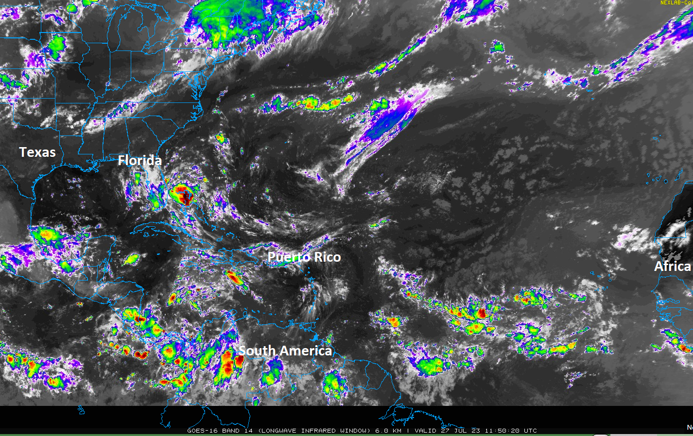
While that is certainly beefy looking, it’s being entirely driven by an upper-level low, not a surface-based system. Tropical development is unlikely to nil in that case. Though, this will hopefully do something to temper the outrageously warm water temperatures surrounding Florida right now. That said, modeling is actually latching onto the tropical wave located this morning around 30°W longitude. If we look at that on satellite, we’re probably all giving it the Larry David treatment.
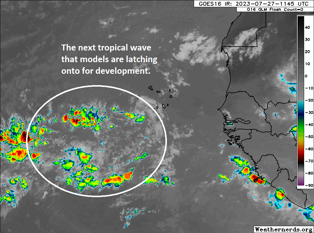

But! As we go through the next few days, this area is expected to consolidate some and become a little better organized. It will track generally west or west-northwest. Modeling insists it could develop. There is actually very good agreement between the GFS and European operational models and their ensembles (which are 30 to 50 different runs of the model with various initial tweaks) that this will develop, albeit not in a huge way. That aside, this is arguably the best agreement we’ve seen since Don formed. In my estimation, models have tended to be rather aggressive with development in the main development region (MDR) and Caribbean this year. So, while odds of development are on the increase and there’s good model agreement on this, we’ll see. Model odds of development over the next week are probably closer to 80 or 90 percent, but given recent struggles, the NHC estimate of 40 percent seems much more realistic to me.
Anyway, development of this system will likely be slow as it comes westward over the next 3 to 5 days.
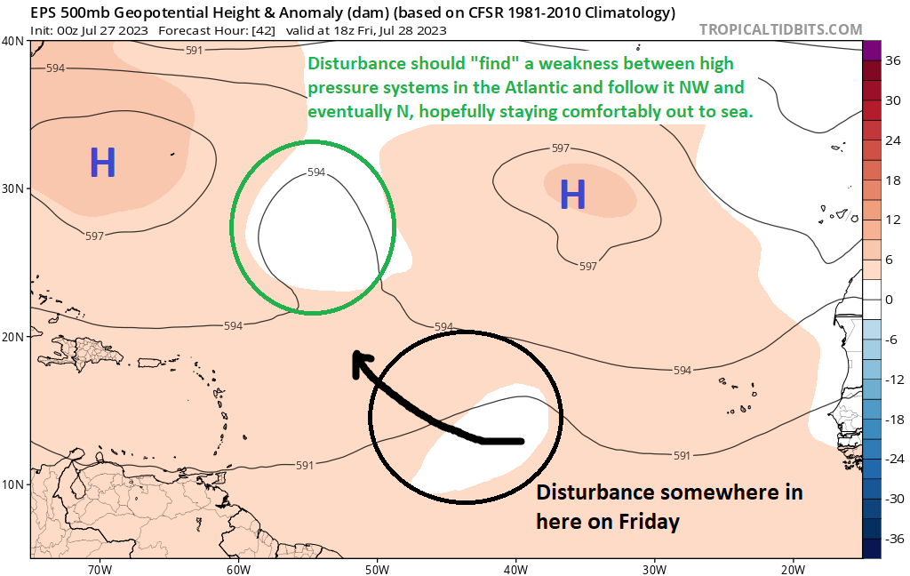
The medium range (days 6 to 10): That tropical wave (should) swim with the fishes
One other thing that the models are in good agreement on right now is that whatever happens with this tropical wave, it is likely to turn northwest and north and eventually out to sea, missing the Caribbean and the U.S. Never say never, but that’s comforting for now. I would argue that there’s good reason to watch this if you are in Bermuda though just in case.
Beyond this wave, there’s nothing terribly exciting to focus on in the tropics through day ten.
Fantasyland (beyond day 10): All good for now
Quite frankly, it’s almost disturbingly quiet on the models right now out in the extended range. It does seem like we’re entering a briefly hostile background period in the Atlantic beginning around the first day of August. This is due to background activity associated with the Madden–Julian oscillation and convectively coupled Kelvin waves. I won’t get into the heavy details here, but you can read and learn about the MJO and hurricanes and convectively coupled Kelvin waves here. Eric Blake at the NHC is a great forecaster, and this presentation that the WMO has online is really useful. All that to say that I would suspect that things pick back up again after August 10th or so.


A storm swelling up out of the warm waters; that’s the scenario I’m most worried about this year 🌊
How can you see something like that coming?
*swelling up suddenly
We’re going to wake up one morning and find the entire Gulf covered in Cat 5 hurricanes. All, of course, headed for Houston.
What’s the Larry David treatment?
The gif that was posted right underneath the statement with the guy(Larry David) making facial expressions is what I presume they mean by “the Larry David treatment”.
It would be nice to get that upper level disturbance to mosey over here and wash away the tumbleweeds rolling in the streets.
At this point I’d take a SMALL storm to put some moisture back in the soil! Us farmers and others who depend on moisture are really struggling 🙁
Just not another Harvey please Lord
no such thing as a “small” storm therse days stranger