We continue to slip back into drought across the Houston area, and all of Texas for that matter. Since last week’s update, the report issued on Thursday showed drought expand to cover over 35 percent of the Houston region, up 5.5 percent since a week ago. Meanwhile, severe drought has arrived for eastern parts of the metro area into Liberty and Chambers Counties.
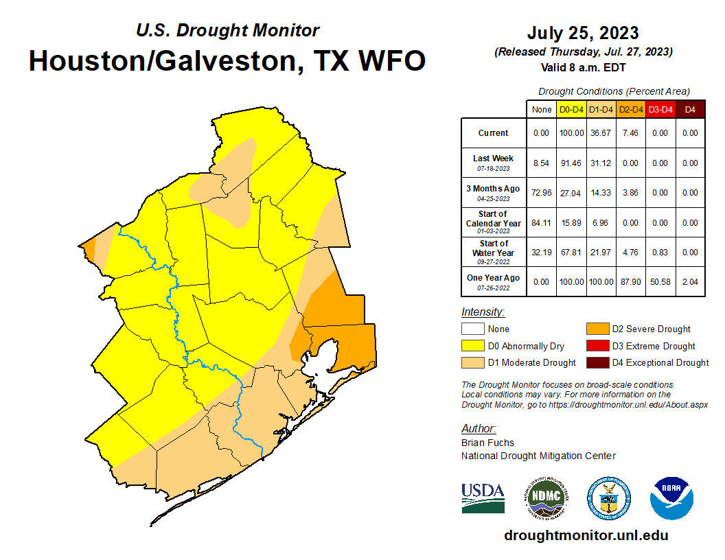
Texas as a whole is seeing severe drought grow, up to almost 20 percent of the state now, up from about 6 percent a month ago. We’ve fortunately had some downpours pepper parts of the area this week, but it’s not even close to what we need to start reversing this process. We’re far off, and the upcoming weather pattern seems to suggest we are not getting any closer to resolution.
Today
More of the same. Look for high temperatures in the upper-90s and a few cooling showers here or there that you can thank your lucky stars, should you receive one.
Weekend
Hot! Rain chances drop from a paltry 15 percent or so on Friday to 10 to 15 percent on Saturday and 5 to 10 percent on Sunday. And even those values may be somewhat generous. Look for heat index values to tick upward into mid-100s again, possibly back to borderline heat advisory levels by Sunday afternoon. High temperatures will be in the upper-90s on Saturday and near 100 degrees Sunday and lows will be in the 70s to near 80 once again.
Next week’s heat
So if you follow the animating map below, you’ll see what’s happening next week. High pressure, or the core of the heat is established over the Southwest today. By Sunday, it will focus over Colorado, and by Tuesday, it’s centered right over Oklahoma and North Texas.
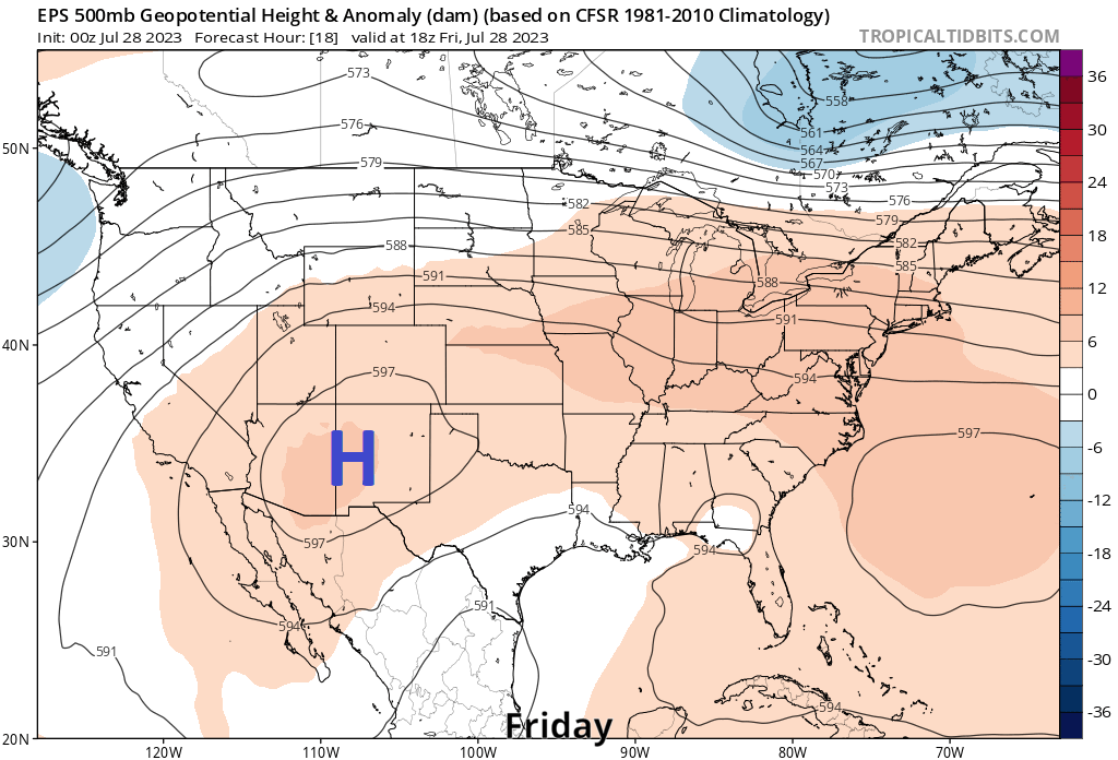
This means that the core of the heat will follow. We’re in for it next week, folks. No way to sugar coat this.

Models have generally been running too hot in terms of temperature this summer, but we’ve more than made up for it with humidity. Regardless, expect a string of heat advisories pretty much every day next week, with highs generally 99 to 102°, high humidity, and morning lows around 80 or so. It may not *feel* quite as bad as what we saw in June and earlier this month, but it won’t be off by much.
The high pressure ridging that focuses the heat may retreat back to the Southwest by next weekend, which should hopefully allow for just basic summer heat instead of the next level stuff we get next week. But I will say that some models are hinting that as the ridge pulls back to the Southwest it will strengthen further (yesterday’s 12z GFS model had the strongest modeled ridge I’ve seen on a model in my entire career). You can see that on the above animation. While extreme heat would stay to our west in that scenario, it may mean that we continue predominantly near 100 and mostly dry into the first full week of August. We shall see, but I see no reason to think any significant change will occur in Houston anytime soon.

So what of rain chances? Not great. We max out today and maybe next Saturday around 15 or so percent. That’s about the best we can muster right now, and even that may be a little generous. We know some folks, especially those that are in farming are hurting and need rain. We wish we had better news.


Well, you are the weather guys – do something about it. 😉
The problem is, if we move the ridge now, it opens us up to the Gulf of Mexico. Which may start to get frisky in a few weeks.
It’s strange how this heat dome stays parked over Texas for months on end while other areas don’t, even places in the south. I grew up in Louisiana, same latitude just to our east, and for 20 years never saw droughts or heat waves like we get here.
I went to Destin last week, temps around 90 caught a few showers, it was heaven!
I go to Yellowstone next week. Highs in the 70s lows in 50s, practically no humidity, and cool fronts arriving in August. Hoping all this heat and drought are gone when I return in October.
Just got back from Yellowstone. Stayed in Island Park, Idaho. Low one morning was 41!
What is causing this heat wave, why are we more influenced by persistent high pressure ridges this summer? Is is El Niño or La Niña ?
I am sure El Niño is playing some role…but sometimes you just get patterns like this that setup and cause hot summers. It would be a hot summer without El Niño or climate factors I am sure…maybe only a couple degrees cooler. But at least maybe a little noticeable.
Notice the High is hovering over the eastern and southeastern parts of the Rocky Mountains.
Houston weather is miserable for 8 months of the year. This is just par for the course.
I’m not sure how to read the headline. Is it (more substantial) heat or more (substantial heat)? That is, is the heat more substantial or is there more of it?
Why not both? The heat, which is already substantial, will be even more substantial next week. Which is to say, bad.
If interested, suggest reading up on Pacific Meridional Mode (currently very negative) and Atlantic Meridional Mode (currently very positive). These are two other much less famous oscillations that also affect our weather and modulate the effects of ENSO. Again these oscillations line up somewhat randomly so your weather is like a slot machine. It would be logical that warming climate would also affect how these oscillations fall in line. All the news is on the North Atlantic and Med anomalous sea surface Ts (those crazy red and orange charts) but you only have to look at the anomalously cold Ts off the coast of California to realize there are no simple answers for heat dome presence.
I saw a reference to the Hunga submarine volcanic eruption. Is this why we are seeing this rapid heat-up? It says we will be dealing with this for three years, or so.
From nature.com
“The perturbation of stratospheric water vapour burden by 13% is tremendous and has no frame of comparison in the entire observation record dating back to 1985. As there are no efficient sinks of water vapour in the stratosphere, this perturbation is expected to last over several years. Indeed, in 9 months since the eruption, the water vapour mass anomaly has gradually decreased only by 2.5% (4.3 ± 0.1% annual rate), which should lead to the perturbation timescale of over 3 years, assuming the further linear decay trend. The persistent stratospheric moist anomaly may lead to changes in atmospheric radiative balance;20,24,25,53,54 stratospheric dynamics26 as well as amplification of the polar ozone depletion through wider occurrence of polar stratospheric clouds31. The ability to assess the longer-term impacts of the HT eruption on stratospheric chemistry will depend strongly on the quality and availability of global satellite observations such as MLS in the coming years.”
“This extra water vapor could influence atmospheric chemistry, boosting certain chemical reactions that could temporarily worsen depletion of the ozone layer. It could also influence surface temperatures … since water vapor traps heat.
“We’ve never seen anything like it,” said Luis Millán, an atmospheric scientist at NASA’s Jet Propulsion Laboratory in Southern California.”
I was about to pose something similar on Hunga Tonga volcanic eruption of 2022. I just read this morning as well. Odd how we never heard about it at the time. The moisture in the atmosphere graphic is astonishing. Fascinating stuff!
This was actually talked about a lot in the weather community! No one really could say one way or another what it meant at that early time though. But this is the one that sent the pressure waves rippling across the world multiple times and could also be “heard” in parts of Alaska I believe.
And imagine seeing the lightning show it triggered: over 2600 flashes per minute!
https://www.sci.news/othersciences/geoscience/tongas-hunga-volcano-eruption-plume-lightning-12024.html
There’s no conclusive evidence — yet. But I would be willing to bet sums of money that Tonga’s volcanic eruption that you reference is playing a part in this, perhaps a significant one, in addition to all the other factors at play.
There’s a timely article that should hit tomorrow’s print edition of the Wall Street Journal: The Economic Cost of Houston’s Heat: ‘I Don’t Want To Be Here Anymore’. I’m sure many of us can relate to that sentiment:
https://www.wsj.com/articles/i-dont-want-to-be-here-anymore-the-economic-cost-of-houstons-heat-3cf69016
Fear not! Glenn is back with his semi-daily dose of hope…
Just 4 short years ago a rare July front passed through and on the 25th of July, 2019 the temperature dipped to 66F at IAH and we only reached a max of 91F. Proving that even in a warming world we can have reasonable temperatures even here in Houston.
Which was then followed by six consecutive 100s in August 2019.
Less mosquitos though without the rain, always positives.
Thanking my lucky stars. Getting a little shower here in west Montrose near Woodhead and West Gray.