Summary: In this post we discuss the very wet start to 2024 in Houston. As for the forecast, our skies will turn sunnier later today, and remain so for a few days, with cooler nights. We’ll then warm up through Saturday, with a smattering of rain chances to end the work week, and better odds with a front later this weekend.
Winter rains
We are now a little more than a month into the new year, and I don’t know about anyone else, but my backyard is a swamp. Through this weekend, Houston’s official station at Bush Intercontinental Airport has recorded 10.50 inches of rainfall. In the city’s records, which date back more than 140 years, we have only surpassed that total on two different occasions: 1891 (13.12″) and 1991 (11.73″).

Matt put together the chart above which shows accumulated rainfall, by day, for each year in Houston since 1950. (The chart only includes data for the last 75 years for the sake of visibility). This year is shown in dark black. The year which sticks out like a sore thumb, of course, is 2017 when we were drenched by Hurricane Harvey.
This year’s rainfall is part of a fairly typical pattern for an El Niño winter, which tends to cause wetter conditions due to the placement of the jet stream. The pattern has produced an enormous amount of rainfall over California in particular this winter, which Matt has explained more deeply on The Eyewall.
Monday
Winds are continuing to blow across the metro area, with gusts up to 30 mph in some areas during the last hour. This northerly flow should start to ease a bit later this afternoon before the winds die down tonight. A few light showers are falling this morning, but they should end soon. With clearing skies this afternoon, highs should reach the mid-60s. Low temperatures tonight will drop into the mid-40s in Houston, with cooler conditions for areas further inland.
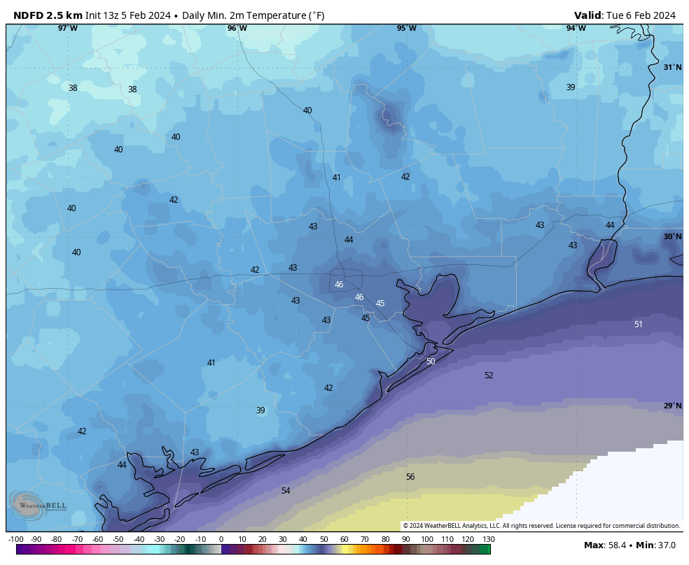
Tuesday
This will be a fine, sunny day. Expect light winds, low humidity, and highs in the mid- to upper-60s. Lows on Tuesday night will drop into the mid-40s.
Wednesday
With the return of an the onshore flow on Tuesday night, we’ll see a fairly pronounced southerly breeze on Wednesday. This should bring increasing cloud cover during the afternoon hours, with highs topping out at around 70 degrees. Lows on Wednesday night will only drop to around 60 degrees.
Thursday and Friday
The combination of increasing moisture in the atmosphere and a front stalling north of Houston should result in some cloudy and warmer days to end the work week. I think highs will get into the mid-70s, with fairly humid air. Some scattered showers are possible, although I would peg daily chances only at about 30 percent, with slight accumulations.
Saturday and Sunday
Saturday should be warm again, with highs perhaps in the mid-70s, and cloudy skies. After that I don’t have great confidence in the details. At some point a front is likely to move through with some attendant rain showers. My best guess for the timing of this is Sunday morning, but that’s somewhat of a crapshoot at this point. Sunday’s temperatures will be dependent on the timing of the front, so they could be in the 60s or the 70s. I don’t anticipate an enormous amount of rain with the front, perhaps something on the order of a few tenths of an inch in the Houston metro area with the possibility of higher totals north of the city. We’ll see.
Next week
Next week looks cooler, with highs in the 60s, and lows perhaps in the 40s or 50s. But after that I don’t have much confidence in whether we’re dry, or some showers hang around early in the week. We’ll have to iron that out in a future forecast.

When will El Nino get gone 😂 asking for a friend. I don’t like El Nino!
El Niño is likely to be gone by late spring or early summer. The concern I have is that it will be replaced by La Niña, opening the door to a very active Atlantic hurricane season.
If you don’t talk about it, then it won’t happen, right? RIGHT!?
“Dark black”?
“It’s like, how much more black could the line be? And the answer is none. None more black.”
Fitting, since we’ve had eleven inches of rain here.
Hah. Fair point. I probably should have said “bold.”
…for each year in Houston since 1950. (The chart only includes data for the last 75 years for the sake of visibility)
Very interesting chart. While the year of each line is not labeled, it is not hard to identify 2017!! I would be interested in knowing what year that bottom-most line is.
That bottom pink trend with the pronounced flatline in precipitation is almost certainly 2011. That summer was horrible – even worse than 2023, IMO.
Almost certainly 2011, the worst drought in recorded Texas history.
Or 1956
It would be interesting to know the top ten and bottom ten years contained in the above chart.
Do you expect an early spring? ir did al the buds freeze?
It was good timing to have an El Nino winter with the terrible drought last summer. Thankfully we didn’t have another La Nina or the drought could of been historic this year.
I remember one January when there were only 3 days when it didn’t rain at all! I guess that was 1991.
I keep seeing quite a few posts on social media about a polar vortex that will hit around Valentine’s Day and leave us with below freezing conditions for several days.
I don’t believe it is true, but would it be possible for you to confirm the likelihood? My elderly neighbor keeps seeing those posts, and she’s scared we’re going to have another winter storm like February ’21.
Great question Mrs Williams. What are the chances of another hard freeze…asking for my plants? Many thanks. rudy
Well thats 9 days away so any kind of prediction would not be accurate to give for that day, plus that info comes from social media posts… not really trustworthy media source
If they were posting about SSWs and the PV elongating I’d be worried. The washingtonian palms already look dreadful. But they’re not. I just looked. These are posts about a possibility of snow in the NE. Low 40s here at 7A Tuesday is the current view. Certainly a little colder than this week.
I’ve heard this as well and curious.
This from the Weather Channel:
Wed 14 Partly Cloudy 66°/49° 8% E 14 mph