In brief: Thursday is still going to feel very hot across Houston, but by this weekend we’ll return to temperatures in the mid-90s with a slight chance of rain. Next week we’re going to see partly cloudy days, with highs in the low- to mid-90s, and widespread showers. And then, all of a sudden, we’re into September.
Past peak summer?
Golly, I sure hate to write that we’re probably done with the worst of summer, because one never wants to tempt Mother Nature. However, we just experienced a stretch of six 100-degree days (we may add one more today, although I wouldn’t bet on that). High temperatures peaked on Tuesday and Wednesday, reaching 102 degrees at Bush Intercontinental Airport. It’s going to be difficult to top that.
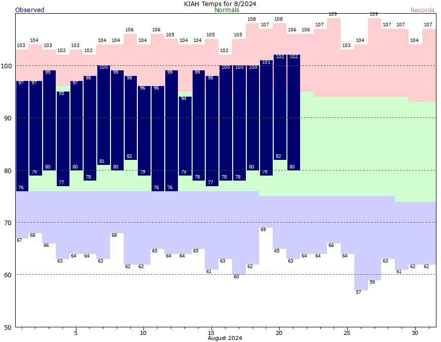
We know for sure that Houston highs are on a clear down slope for the rest of this month. Although we certainly can hit 100 degrees in September, at this point the odds are fairly low that we see another sustained stretch of brutally hot weather. I’m not ready to say we’re done with triple digits, but I really do believe we’re past the worst of the summer of 2024 in terms of heat.
Thursday
Today is still going to be really hot, of course. High temperatures will reach the upper 90s today, and some inland locations may hit 100 degrees. But we should be slightly cooler than on Wednesday. There is, perhaps, a 10 percent chance of showers this afternoon. Winds will be light, increasing to 5 to 10 mph from the southeast this afternoon. Lows tonight will drop to around 80 degrees.
Friday
Skies will again be mostly sunny, but for most of Houston highs will likely peak in the mid- to upper-90s. Some scattered showers will also be possible starting in the morning hours, and persisting into the afternoon with daytime heating. Overall rain chances will be about 20 degrees.
Saturday and Sunday
Overall skies should be mostly sunny this weekend, but there likely will be a few clouds during the afternoon. Most locations should see highs in the vicinity of the mid-90s. Rain chances will be on the order of 20 to 30 percent daily, mostly driven by the sea breeze. Lows will remain warm, but should start dropping into the upper 70s.
Next week
As high pressure backs off further, we’ll see our region open up to moisture from the Gulf of Mexico next week. This will lead to healthy, daily rain chances on the order of 50 percent. Generally, next week, we can expect high temperatures in the low- to mid-90s, with partly cloudy skies, and periodic passing showers with embedded downpours. The likelihood of rain will be greater near the coast, but everyone should have a chance of seeing some showers. We will likely remain in this pattern through most of next week, and possibly into the weekend.
Tropics
The Atlantic tropics are quiet. In case you missed it, we published a long post from Matt yesterday on why that is, and how long it will last.

My car thermometer didn’t go below 90 on the way to work early this morning 🥵
86 at 6:00 AM this morning – and muggy with it.
Talking about Colorado – well, someone might as a better place to live – when we lived there we could always count on the first snow fall in mid September.
After that is was all down hill (skiing analogy).
A while back you talked about your experience with whole a house generator and the company who installed it and services it. You expressed satisfaction with both. Would you broadcast that information again please. John Sanders
John, type “whole house generator” in search (over to the right) and you’ll get two posts. One from Matt (2022) and one from Eric (2021)
Overall rain chances are 20 degrees for Friday?
Will temperatures finally drop below 85 mph at night?
Hi. My home electronic temp gauge read yesterday at 1405 hours, 105 degrees Fahrenheit and the Heat Index read 131 degrees Fahrenheit!
I Wish there was a way to post pictures of what I observed so others may see it for themselves.
Possibly an addition in the future Matt/Eric?!
Anyhow, thanks for allowing me to post.
May God Bless you all & God Bless Texas!
Hello @S … do this – go to Weather Underground (wunderground dot com) and submit your Personal Weather Station information. (PWS).
After acceptance, your PWS weather statistics will be shown on the Wunderground app (and website) every few minutes, providing other folks in your area your weather stats. You will have your own Wunderground URL and website stats)
If you’ve never seen this site, go to “wunderground dot com”, click Search, enter your Zip code, then you can see all the PWS’s in your immediate area, and choose one (change to another any time, just click “Change Station”).
Because we’re in a sorta rural area of Magnolia, we can’t rely on Houston area stats, or Hou.Intercon.Airport stats … we only rely on PWS’s that are within a 2-4 mile radius of us
I will truly believe the worst of summer is over when I see that first cold front heading to Houston that puts us in the 60s for over night lows.
same. I distinctly recall it being in the 100s in September last year (granted, I know the heat dome was here), so I’ll believe it when I see it. I have experienced high 90s in October here plenty of times.
For me, summer isn’t truly over until mid to late October. Even when we get a decent cool front in late September, it can still get really hot and horribly muggy through early and mid-October when the winds return from the Gulf. The intense heat and humidity usually breaks in late October when we get that first strong push of cool-to-chilly air. Our last 90-degree day on average is October 7th, but it can and has hit 90 well past that date. November is our true Autumn month. It can still get very warm in early November, but most days are in the 70s and nights in the 50s and 60s. In Houston, it has never hit 90 degrees in November. Not yet anyway.
Is there some sloppy tropical circulation expected for the upper Gulf next week?
We had better watch out once the high moves out, because ocean heat content in the Gulf is at all-time record high levels. (https://bmcnoldy.earth.miami.edu/tropics/ohc/)
Those ranges look like 87° to 91°F in the GOM. That’s scary hot.
Hurricanes only need about 80°F to form.
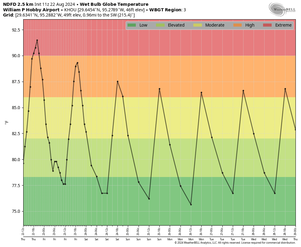
I believe somewhere I missed the explanation on how to understand the chart you have posted under the Saturday/Sunday section. Would you mind reminding us how to read that?
This is the best explanation I’ve seen from the “Explain it like I’m 5” Reddit:
I’m going to start off with why it matters because the definition of what it is makes a little more sense with the background.
Like a car engine, our bodies can overheat and break. If it’s hot outside, we need something to cool us off. Luckily for us, evolution gave us a solution: sweat. Sweat is mostly water and has a high thermal conductivity, which means that heat transfers to/from it faster than other materials. When we sweat, it absorbs some of our body heat then evaporates into the air, taking the heat with it.
Now, this isn’t perfect. There are situations where sweat will do nothing. Air can only hold so much water. When you see humidity measurements, it’s always in %. Well, that % is how much water is in the air compared to how much it can hold. At 100% humidity, the air is holding a much water as it can and water can no longer evaporate.
When this happens, sweat can no longer do anything to cool us off so we have to rely on the air temperature, which most of the time is also enough to prevent us from overheating.
However, in recent years, we’ve been having weather events where not only is it very humid but also very hot. It’s humid enough where sweat can’t cool us off and hot enough where the ambient temperature doesn’t do it either, so we overheat. This is a “Wet Bulb Event”
So then, what exactly is “Wet Bulb Temperature”? What we do to get it is take a thermometer and wrap the bulb with a wet rag. The rag acts like sweat soaked skin, so it cools off the thermometer. It’s effectively a measurement of how effective our natural cooling will work. To add to this, while our bodies operate at 98.6 °F, it actually needs to be cooler than that to prevent overheating. 94 °F is around the temperature we begin to overheat. If the Wet Bulb Temperature is 94°F or higher, being outside is incredibly dangerous as you WILL begin to overheat, and as such when the wet bulb temperature is 94 or greater, that’s a wet bulb event.
That’s good
Suggested Actions and Impact Prevention
WBGT(F)
Effects
Precautionary Actions
< 80
80-85 Working or exercising in direct sunlight will stress your body after 45 minutes. Take at least 15 minutes of breaks each hour if working or exercising in direct sunlight
85-88 Working or exercising in direct sunlight will stress your body after 30 minutes. Take at least 30 minutes of breaks each hour if working or exercising in direct sunlight
88-90 Working or exercising in direct sunlight will stress your body after 20 minutes. Take at least 40 minutes of breaks each hour if working or exercising in direct sunlight
I was shopping around for forecasts yesterday and I saw one forecast with a Low racing across the Gulf from East to West to us next week. Anyone else seen that?
Houston has had 100° Fahrenheit temperatures as late as October 13th.
I’m not quite sure where you got that from. According to NOAA, the hottest temperature Houston has ever experienced in October was 99 degrees on October 1st, 1900. The record high temperature for the 13th was 95 in 2015. Maybe you got that from a local station at somebody’s home, but the official data on NOAA from several stations across Houston’s history has never recorded 100 degrees in October. Now I’m quite sure it has hit 100 degrees in some big concrete parking lots across Houston in October, but to get the accurate ambient air temperature, you have to be in a grassy field far from any concrete and buildings.
Eric or Matt, are you or is anybody keeping track of the heat index / “feels like” temperatures / records?
For example, I have a screenshot from July 14th 2023 where it showed 102 feels like 118. Those are the numbers that really concern/ed me.
Thanks for your great work.
Bob
We have always had brief periods during the summer with peak heat index values in the 110s but it is was usually only a few days out of the whole summer. They were far and few between over the previous decades. It didn’t used to happen every summer and for weeks at a time like it is now. These extreme heat index days in the 110s are becoming much more frequent in recent years. The past 3 summers the heat index values have been off the charts. This is because dew point levels are rising significantly along the gulf coast due to the warming waters.
Some of this could be attributed to the Hunga Tonga volcanic eruption that spewed 150 million tons of water vapor into the atmosphere. However, the top climate scientists have said that the warming impact of this eruption is pretty small and minuscule compared to the warming effect that the excess greenhouse gases in the atmosphere are causing. So, expect the dew points to keep rising during the summers in the future as the Gulf waters continue to warm more and more. We will probably start having heat index values hit 120+ regularly during the 2030s and 2040s summers. We will also probably start seeing overnight lows fail to drop below 90 degrees especially along the immediate coast.
It’s going to get very bad down here in the future. Hopefully later instead of sooner but the rate of warming we have already seen just in the 2020s is nothing short of unprecedented. I am predicting a huge population drop in the southern states in a couple of decades because everybody is going to start moving north to cooler climates because it’s going to get too hot and dangerous down here in the southern states.
I’m happy to see that the end of the severe heat is nearing! This seemed to be a pretty normal summer for us (I’m a native Houstonian): warm but wet in June and July (and yes, a hurricane) with a hot, dry August. Compared to last summer’s ridiculousness, I’ll take it!