Note: Braniff Davis, who is finishing a master’s degree in meteorology from San Jose State University, is joining Space City Weather as a contributor. He and his wife will be moving to Houston this summer, and he’s offered to help explain the why’s of Houston’s weather, and will also be tracking air quality and related issues for the site. Please welcome him!
On Monday, May 9th, the Houston metro area woke up to a strong wind event that rattled the region. Weather stations measured sustained winds over 20 mph and wind gusts in excess of 40 mph, with a station southeast of Missouri City picking up a regional maximum of 51 mph at 8:22 am.
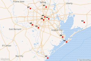
Several people noted the strong winds on the Space City weather Facebook page, so we thought it would be worth exploring why the winds were so strong this week.
One of the first concepts taught to meteorology students is the idea of the pressure gradient force, or PGF. Basically, the differential between low pressure and high pressure in the atmosphere creates an imbalance. Advection—or, wind—occurs when air in high pressure areas rushes to ‘fill in’ areas of low pressure. That wind becomes stronger when there is a greater PGF—that is, when pressure changes quickly over a short distance.
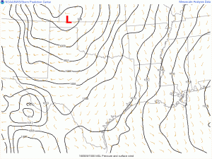
The plot above shows the low pressure center over the Oklahoma panhandle on Monday. Isobars, or lines of constant pressure, circle the area of low pressure. When isobars are close to one another, it indicates a strong pressure gradient, and is a definite sign of some strong surface winds. As the plot shows, there was an area of tightly packed isobars over Houston that day, indicating strong inland winds flowing to the lower pressure. That pattern persisted until Wednesday, when the pressure gradient widened, leading to weaker winds across the region.
The sea breeze forecast for this weekend is another example of pressure gradient force creating winds. In this case, surface heating creates an area of low pressure over the land. Cooler, higher pressure air over the Gulf of Mexico then rushes toward that low pressure, creating a wind flow. As we approach our 90 degree days, the local pressure gradient will be enough to drive winds again. Monday and Tuesday could see gusts as high as 15 to 20mph.
Posted at 11:25am CT Friday by Braniff Davis
Welcome Braniff and family!! Hope you enjoy Houston’s nice warm summers!! Glad to have you on board!
Pretty certain that 37 mph reading in Cypress is my weather station. Awesome!
Very didactic. Thanks!
Welcome, Braniff!
And an early welcome to Houston!
Welcome, Braniff.
Are winds naturally attracted to low pressure and not to high pressure?
PGF always causes flow from high pressure to low pressure. In my class, I always used the concept of two water tanks, connected by a pipe at the bottom. If you fill up one water tank (creating high pressure), that will force water to flow into the other tank (with lower pressure). Other forces like Coriolis and friction influence wind in the atmosphere, but PGF will always drive winds from high to low.
Thanks for the warm welcome, everyone!
Pun intended? 🙂
Welcome Davis family! Just in time for Houston Summer to give you a welcoming committee!
Explains why I found my bottle of Roundup fallen off the picnic table and spilled on to the patio. Fortunately the patio, not the yard.
Adding to the welcoming committee for the new contributor, Braniff Davis.
Just from the first submission, I can see we’re going to be getting even more knowledgeable depth on our favorite topic.
Looking forward to more of your future enlightening.
Welcome!
I enjoy getting into the details of why Houston’s screwy weather does what it does. 🙂
I learned something today! And it will enhance my understanding of something I already spend an inordinate and inexplicable amount of time obsessing over. I would have LOVED to be a meteorologist – but I can’t Math.
Welcome to Houston Braniff and Wife. Bring umbrellas, swimsuits, shorts and lightweight, breathable clothing. And don’t believe anyone that tells you you’ll acclimate to the heat/humidity – they LIE. It’s a “therapeutic” lie, told with the best intentions and the hopeful promise of relief, but a lie nonetheless. It gets better – in December.
When my Dad moved here from Portland, he carried a face towel, a clean t-shirt and dress shirt in his briefcase for the first 3 summers he was here. He didn’t acclimate – he just gave up. The upside is, he pretty much stopped aging once he got here. I think it’s the humidity.
You should also know that we are a friendly bunch – until we get into our cars and on the highways. It’s nothing personal. We’re all a***oles behind the wheel. In time, you’ll join us and fit right in.
If you have kids, or plan to in the future, hook up with Sarah Gish on Facebook and Twitter. She is kind of a local expert on fun, educational, cultural things to do here.
LOTS of transplants here (I’m one myself). You’ll make friends fast. 🙂
…when Eric started this no-hype, just solid, pertinent data Wx gig I was happy with one no-nonsense guy…then Matt came along and the no-hype and just good data/info doubled…HOLY COW, three of ya now…great stuff guys!
Before you know it we’ll be the Houston metro area’s leading online source of weather information!
If you’re not already, you should be. Welcome to Braniff and wife!
Go for it…being accurately informed would beat creeping along in a car on an Interstate Rd for 12 hours while evacuating to a normal 90 minute drive location learning later that my son, who stayed behind in our home had NO problems!!