In Houston and along the Gulf Coast, there’s no definitive “start” to summer. As a meteorologist however, I usually signify the true start to summer here as being when you have to include a chance of thunderstorms in the forecast almost out of pure obligation. Maybe you get one or two and the majority of the region stays dry (though, hey, last night was a little wild, right?), but you are obligated to include that chance. I feel like that really started yesterday. You may have your own definitions on when summer truly begins, but I am arbitrarily declaring summer in session. Away we go…
TODAY
You may wake up to some fog south of Houston, but the radar is mostly quiet this morning. A weak cold front will essentially wash itself out over the area today. It’s basically along or just south of I-10 this morning, and it probably won’t get much further.
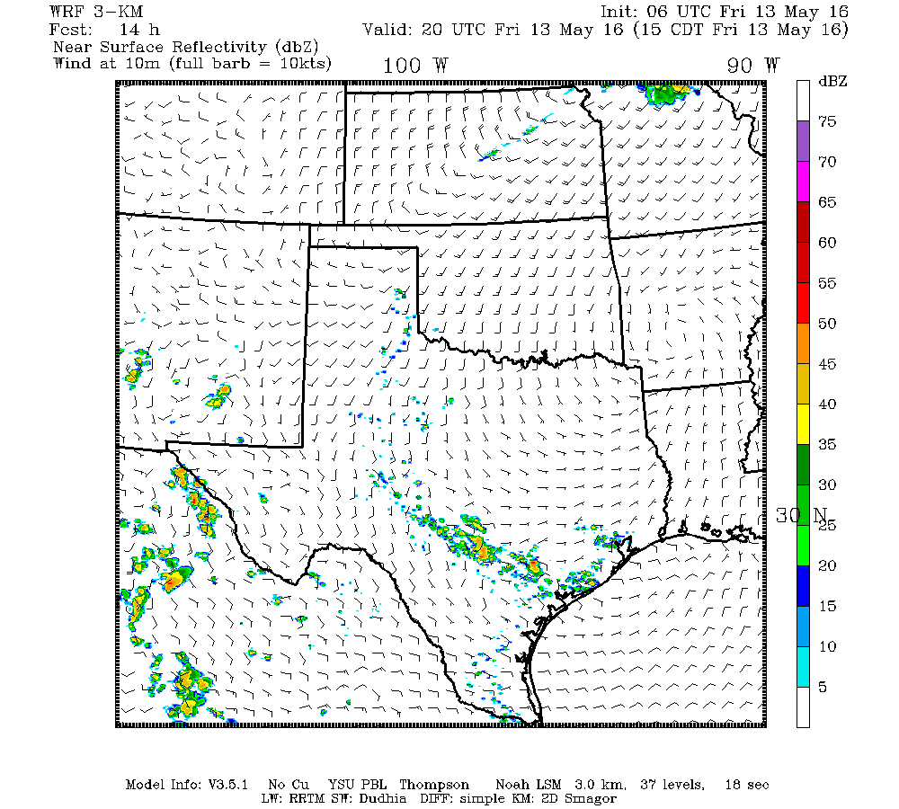
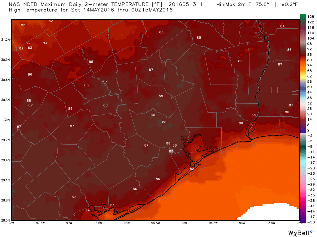
The models generally agree that the best chance of storms today will be south and west of Houston. That doesn’t mean we couldn’t see one pop up anywhere in the region today, but the odds are highest toward Wharton, or El Campo. We will heat up enough to develop a sea breeze off the Gulf, so that may also act to focus some pop up storms elsewhere in the region. Otherwise, hot and humid. We fell just short of 90 yesterday, and I think we’ll fall just short again today, but it’s going to be close. Upper 80s to 90ish inland today, but if you get a cooling shower, it’ll drop into the 70s for a time.
SATURDAY
Another weak cold front will try, but fail to get through the area. The first half of the day looks good, but as that front approaches, we could see showers and storms kick off. Unlike Friday, I think the best chances will be north and west of Houston during the afternoon, perhaps closer in during the evening. So if you live in Brenham, Conroe, or Livingston, your chances are higher tomorrow afternoon. In Houston, if you’re planning to check out the Dynamo/Real Salt Lake match or perhaps Rice baseball against Florida Atlantic, keep the threat for evening storms in mind. If we can hold the rain off enough, there may be an outside shot at 90 degrees Saturday, but it won’t matter much either way: Continued hot and humid.
SUNDAY INTO NEXT WEEK
Sunday will be a bit tricky. Saturday evening’s storms will form along yet another cold front trying to drop into the region. That will be weak, but it could act as a focal point for some hit or miss storms during the daytime Sunday. If I absolutely had to put a number on it, I’d say about a 20-30% chance of a daytime shower or storm basically anywhere in the region.
Sunday night into Wednesday night (or beyond) is when things could turn interesting here. I’m anticipating at least two rounds of thunderstorms. The best windows for rain are Sunday night into Monday afternoon and again Tuesday night into Wednesday.
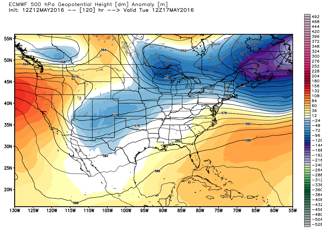
A rather strong upper level weather pattern for mid-May will pester the Eastern 2/3 of the US next week. This means abnormally strong cold fronts can get abnormally far south. You see where this is going.
Monday is low confidence. The European model has been aggressively showing heavy rain and thunderstorms Monday, whereas the GFS has been sort of agnostic about the whole thing and just shows some scattered showers or storms (though it did trend a little stormier overnight). Right now, I’d split the difference and say a good chance of scattered showers or storms, possibly coming from a large complex of storms that moves from Central Texas late Sunday night. Honestly, details are very much TBD at this point. We’ll keep an eye on this for you over the weekend, and we’ll probably update you on Saturday afternoon or Sunday morning.
Oddly, the forecast for Wednesday may actually carry slightly higher confidence than Monday. A cold front will likely approach and potentially clear the region. A band of heavy rain and thunder should accompany this one. If we’re lucky, we may get a day or two behind that front with slightly lower humidity to round out next week. Fingers crossed. If the front stalls, then forget that, and we’ll add more thunderstorm chances late next week.
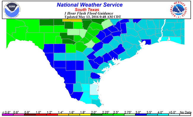
In terms of severe weather and flooding: As is always the case in May with storms in Texas, both are possible. In terms of severe weather, there isn’t anything alarming for any day, and the main threats would be large hail and strong, damaging winds. In terms of flooding: We’ve had ample time since Tax Day to dry out and can handle a fair bit of rain right now; in fact, most areas could feasibly handle 2-3″+ of rain in an hour before flash flooding becomes a serious issue. As we saw last night, that’s not impossible to do though, so while I’d classify a serious, widespread flooding risk as low right now, localized street flooding is likely to be an issue at times in parts of the area. It’s something we will continue to monitor, and we’ll keep you posted as we get closer and throughout!
We’re in agreement on the beginning of summer, although our criteria differ. I work outdoors — varnishing boats. Just two days ago I began having to wipe away sweat, and began thinking about drinking more water. As various workers on the docks were saying to one another, it looks like summer is here.
I agree about the timing of the summer season. When I walk out of my office, it’s 90 degrees and I feel like I’m in a sauna….. it is definitely summer in Houston! SO not ready for 90 degree days and 85 degree nights. A/C running 24/7 now, windows closed and ice water in hand.
I consider Cinco de Mayo the unofficial start of summer in Houston. Why not end spring with a party — we need all the help we can get to make it through the summer!
This is a philosophy I can support!
I’ve always maintained that Houston has only two seasons: Warm and Hot. Hot season begins when ave temp highs are above 92f. I’ll stand by that assertion!