Good afternoon. Matt’s forecast from this morning still holds up pretty well, but I wanted to provide a quick update on storm possibilities looking ahead.
FRIDAY EVENING
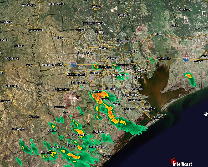
We’ve seen some strong thunderstorms fire up from the Lake Jackson area to Alvin this afternoon, and we’ll continue to see at least some scattered development through the evening hours as temperatures remain in the upper 80s helping to fuel these storms. Much of Houston will not see rain, but where these storms do fire up this evening they have the potential to be intense and flood streets. Small hail is also a possibility. I do not expect coverage to be quite as widespread at Thursday evening, but these things are hard to predict. Storms end by 9 or 10pm with the loss of heating.
SATURDAY
I think Saturday will start out a lot like today, with sunny conditions in the morning. However we’ll see the sea breeze set up again, and along with daytime heating we could see more scattered showers and thunderstorms. An additional concern is that some forecast models show a weak cool front moving down from the north and stalling over Houston. If this area of instability meets up with the sea breeze we could see some heavy rain during the evening hours and beyond midnight. This remains uncertain, but we’ll be watching this possibility for you.
SUNDAY NIGHT into MONDAY
Sunday could see some more afternoon storms along the sea breeze, but a bigger concern comes Sunday night and into Monday. We’re likely to see some winds about 10 miles above the surface that are quite strong, and may induce rising air at the surface. Forecast models are pointing to the possibility of 1 to 3 inches of rain for much of the Houston area, with higher isolated totals. It’s not clear yet whether the heaviest rain will come Sunday night, or during the daytime hours on Monday. But it’s something we’ll just have to watch for now.
Unstable weather is possible through much of next week, but that’s enough to worry about for now.
Posted at 4pm CT Friday by Eric Berger
Eric, you said:
“I think Saturday will start out a lot like today, with sunny conditions in the morning. However we’ll see the sea breeze set up again, and along with daytime heating we could see more scattered showers and thunderstorms. An additional concern is that some forecast models show a weak cool front moving down from the north and stalling over Houston.”
Well, the current (00z) runs of the NAM ensemble have a gift for you, Eric.
1. NAM 12 shows only showers around Houston, but not in Houston at hour 12
2. NAM 4km places a line of severe thunderstorms to the NE of the metro and moves them east.
3. HRRR puts no activity in Houston at 16Z
4. GFS: Well, we might have a problem on Tuesday, as opposed to Saturday 14th.
5. CMC: had placed 6 inches of rain in Houston but has instead cut back its prediction to 4″.
Will be back with another comment on 00z of GFS/CMC as I get them.
How am I doing, Eric?
Update 4U Eric:
1. Tx. Tech (current run) only shows 1 potential supercell to the south of the Houston metro.
2.Can’t say I care much for the radar reflectivity of the Tx. Tech model. Please say that’s not chiseled in stone!
From SPC:
MODERATE INSTABILITY WILL RESIDE IN TX PRE-FRONTAL WARM SECTOR…BUT
MOISTURE AND CAPE WILL REMAIN MORE LIMITED FARTHER WEST ACROSS SERN
NM AND FAR WEST TX. ONGOING MCS WILL LIKELY CONTINUE TO WEAKEN AS
IT DEVELOPS SWD INTO AN INCREASINGLY CAPPED ENVIRONMENT ACROSS CNTRL
TX…AND EARLY THUNDERSTORM DEVELOPMENT WILL PROBABLY BECOME
CONFINED TO POST FRONTAL REGION. HOWEVER…AS THE BOUNDARY LAYER
WARMS DURING THE DAY…ADDITIONAL STORMS WILL LIKELY DEVELOP ALONG
SWD-ADVANCING COLD FRONT…RESIDUAL OUTFLOW BOUNDARIES AS WELL AS
OVER THE MOUNTAINS OF SWRN TX AND NM. THUNDERSTORM COVERAGE MAY ALSO
BE MODULATED BY A WEAK VORTICITY MAXIMUM THAT WILL MOVE SLOWLY EWD
THROUGH SWRN TX. WEAK WINDS ALOFT AND VERTICAL SHEAR SUGGEST STORM
MODE WILL BE MULTICELLULAR IN CHARACTER…BUT THE THERMODYNAMIC
ENVIRONMENT MAY SUPPORT A FEW INSTANCES OF DOWNBURST WINDS AND HAIL
DURING THE AFTERNOON AND EARLY EVENING.
1. The key word is “Few”
2. Maybe we’ll dodge some of the worst of the storms, Eric?
Uh-Oh! I’ve seen a radar pattern like that before, everybody. That storm system that TX. Tech depicts could leave a LOT OF DAMAGE in its wake!
Bottom line: Hunker down tomorrow!