In brief: In this morning’s post we discuss the end game for the tropical disturbance in the northern Gulf, look ahead to elevated rain chances on Friday, and then see what high pressure will bring us next week.
The National Hurricane Center has lowered the development odds of Invest 93L.
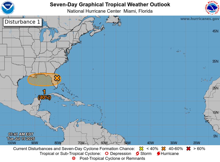
Invest 93L
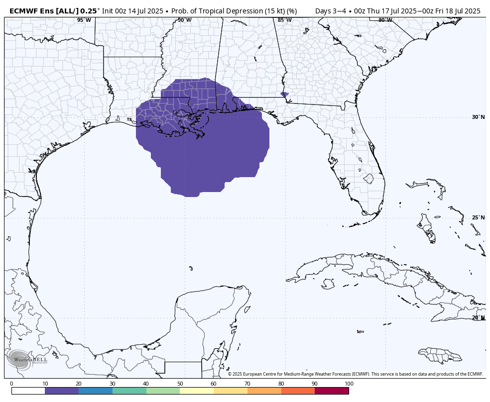
As expected, the tropical disturbance in the northern Gulf of Mexico (aka Hurricane TikTok) is moving steadily westward and nearing the far eastern end of Southeastern Louisiana. The center of the storm continues to hug the coast, which has limited intensification, and thus this system remains poorly organized. The odds of it becoming a tropical depression or storm have been lowered to 30 percent this morning, and even this seems a little generous to me. It should move into Louisiana later today or tonight, bringing a chance of heavy rain to that state. Impacts to Texas will be minimal, although parts of our area will see increased rain chances on Friday as a result of atmospheric moisture related to this system.
Thursday
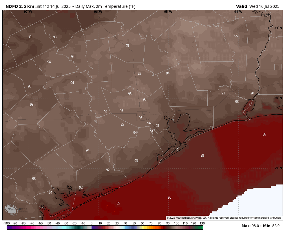
If you liked the weather on Wednesday you are in luck, because today will be pretty much the same. We may see a few more clouds this afternoon, but high temperatures should still reach the mid-90s for most locations with plenty of humidity. Winds will be light, generally from the south. Low temperatures tonight will drop into the upper 70s.
Friday
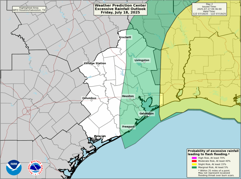
As atmospheric moisture levels rise due to the influence of the tropical disturbance, we will see an increase in rain chances on Friday, but how much will depend on how far east you live. If you are east of Interstate 45 I would put the odds of rainfall at about 50 percent or higher, and to the west I’d say considerably less than 50 percent. Overall accumulations likely will be in the 0.5 inch for areas that receive rain, but with the tropical moisture there could be higher bullseyes. It’s notable that the Weather Prediction Center (see below) has lowered the likelihood that any part of the Houston metro area will see excessive rainfall. Highs will reach the upper 80s to lower 90s due to increased cloud cover.
Likelihood of excessive rainfall on Friday. (NOAA)
Saturday
Skies will be partly sunny on Saturday, with highs generally in the lower 90s, as atmospheric moisture lingers in the region. Rain chances will be about 30 percent, higher again to the east of our region. Accumulations look slight. Overall if you have outdoor plans I would be cautiously optimistic.
Sunday and next week
High pressure begins to build in by Sunday, and this should set the stage for sunny and hot weather for awhile. Most of next week should bring high temperatures in the mid- to upper-90s, with perhaps a 10 percent chance of afternoon showers driven by the sea breeze. It’s late July. It’s Houston. You have been warned.
In brief: In today’s post we take a quick temperature check on TikTok, which seems hot and bothered about the possibility of a hurricane hitting Houston. In the real world, we discuss the forecast for the week ahead, which includes an elevated chance of rain on Friday from a tropical disturbance that is almost certainly going to move into Louisiana.
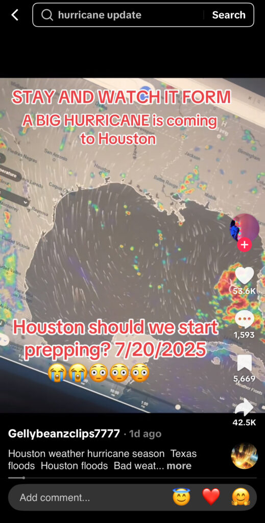
The TikTok hurricane
On Tuesday evening one of my daughters said “everyone” on TikTok is talking about a hurricane coming to Houston this weekend. At first, I thought it must be a few pot-stirrers, because nothing could be further from the truth. Why? Because:
a) There is no hurricane
b) A tropical system that probably won’t develop much is probably not coming to Texas
c) There is no credible basis on which to make such a forecast right now, like none
So we sat down and she showed me some of the videos. (Full disclosure, I just turned 52 years old, and I have only dabbled on TikTok. It’s just not my thing. If it’s yours, that is totally fine. I am not shaming anyone who likes TikTok or creates content there). I was blown away. The amount of misinformation is staggering, and these videos are being watched 100,000s of thousands of times, with this huge influential reach. It was to the point where my daughter was seriously concerned about the possibility of a hurricane coming to Houston, and asked me what we should do about it.
TikTok on Tuesday evening.
I have no desire to try and take on the Chinese government or ByteDance and its algorithm. I realize that misinformation is rampant across social media, not just TikTok, and that people are knowingly and unknowingly spreading it for various reasons. But it frustrates me because this kind of content spreads anxiety, which for some people is crippling; and the inevitable false alarms will only sow doubt and uncertainty when the time comes to take real forecasts seriously.
So with this post I just wanted to reiterate that Space City Weather will never play these games. We are not chasing clout. We aspire, above all things, to be boring and have boring weather to write about. We also acknowledge that we are far from perfect. We will make mistakes in our effort to predict the future, but they are honest mistakes and believe me, Matt and I agonize over them. In short, we are always going to try and bring you the truth about the weather as we see it. In 2025, that mission seems to be more vital than ever. So we fight on. We will do our utmost. I fear it will not be enough.
Wednesday
As pressures rise and atmospheric moisture levels fall, today should be mostly sunny in Houston with virtually no chance of rain. Instead it’s going to be a classic mid-July day with plenty of humidity, and high temperatures in the mid-90s. Winds will be light, from the south at 5 to 10 mph with slightly gusty conditions during the afternoon hours. Lows tonight will drop into the upper 70s.
Thursday
A day similar to Wednesday, although there is a slight chance of afternoon showers and thunderstorms along the sea breeze. Chances are 10 to 20 percent.
Friday
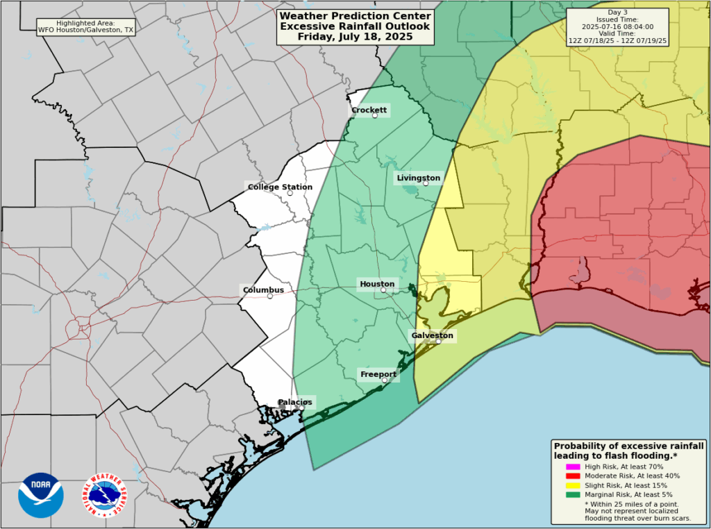
An increase in atmospheric moisture, related to the tropical disturbance in the Gulf, will bring a better chance of rain on Friday. These rains should be concentrated most heavily over Louisiana, and there is likely to be sharp gradient to the west approaching Houston. That is to say, there will be a line west of which rain is unlikely. Where will that line be? Interstate 45 is a decent guess, but the line could also be closer to Beaumont. The map below shows the best guess from NOAA’s Weather Prediction Center. My sense is that areas along and east of Interstate 45 have a decent chance to pick up 0.5 to 1 inch of rain on Friday, with lesser amounts to the west. But this forecast is very much written in pencil right now. Any winds and surge from the tropical system should not be impactful in the greater Houston region. Expect highs of around 90 degrees with mostly cloudy skies.
Prediction for where excessive rainfall is most likely on Friday. (NOAA)
Saturday and Sunday
A decent chance of showers will linger into Saturday, perhaps about 40 percent, but this day should bring partly sunny skies back into the forecast with highs in the lower 90s. By Sunday high pressure should be taking hold, so rain chances should reach closer to zero, with mostly sunny skies and high temperatures in the mid-90s.
Next week
Most of next week looks hot and sunny, with highs in the mid- to upper-90s. Rain chances will be quite low for much of the week, although the upper air pattern could change toward the end of the week to bring precipitation back into the forecast. We shall see.
Invest 93L
So what really is happening with the tropical system? Not a whole lot. The ‘center’ has crossed the Florida peninsula, but it remains close to the Florida Panhandle this morning. This proximity to land will not help with any efforts to develop. Over the next day or so the center should remain very close to the northern Gulf coast, limiting development. There is a non-zero chance that some sort of center organizes further south today, and this would allow for more strengthening. However that appears fairly unlikely. Probably, the low pressure system will continue to track more or less west before moving into Louisiana on Thursday night or Friday, bringing an high chance of rain. The National Hurricane Center continues to indicate there is a 40 percent chance of a tropical depression or weak tropical storm forming before landfall.
Some of the models that were advertising extreme rainfall totals in southern Louisiana have backed off some. However, this is still a favorable setup for heavy rainfall so flooding along and south of Interstate 10 in Louisiana is a distinct possibility.
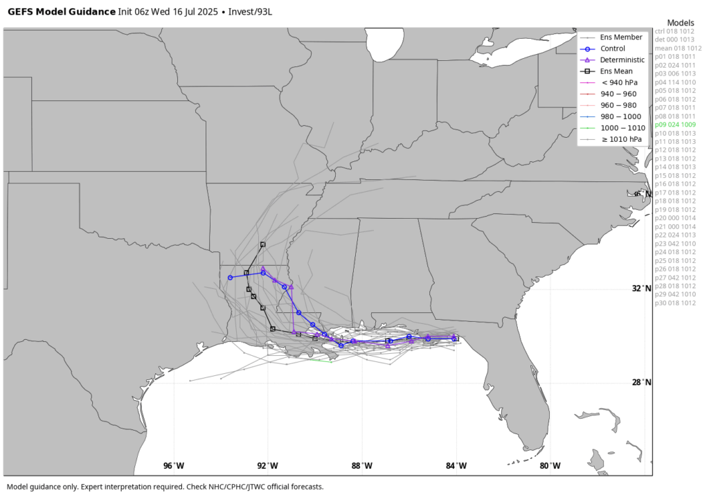
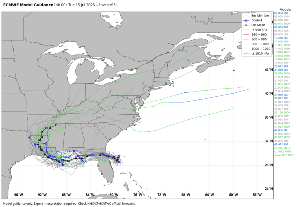
There is good agreement among the GFS model ensembles about what Invest 93L will do. (Weather Bell)
As ever with tropical systems there is inherent unpredictability, especially with systems that have yet to develop a well-defined center of circulation. But time is running out for Invest 93L to surprise us.
In brief: Houston will see less rain and more sunshine for a few days before healthy rain chances return Friday and perhaps Saturday. We are also closely watching the evolution of a tropical disturbance that should move into the northeastern Gulf over the next 24 hours. Although it is likely to remain east of Texas, the forecast is far from certain.
Invest 93L
There has been a lot of chatter about a tropical disturbance, known as Invest 93L, which should move across Florida today and tonight into the northeastern Gulf of Mexico. The National Hurricane Center has increased the likelihood that this system becomes a tropical depression or tropical storm to 40 percent, but in reality we still have more questions than answers this morning.
For example, if the bulk of this activity crosses Florida and then the ‘center’ remains anchored over the Florida panhandle rather than offshore, it has very little chance to develop. If the center (which I used in quotes above, because no center is as yet observable) remains offshore then there is a better chance for this system to organize a little bit. Regardless the majority of modeling still keeps this system weak, as a tropical depression or less. For now I am not really concerned about winds and storm surge.
The bigger issue is rainfall potential, and I think there are risks across the Northern Gulf coast, from Florida to east Texas. The majority of our guidance continues to indicate that southern Louisiana is at the greatest risk for heavy rainfall during the second half of this week, with flooding distinctly possible there, but we cannot rule anything out. As soon as we have some clarity about this system—which is unlikely until after tonight, when the disturbance crosses the Florida peninsula—we will share more. At this time, we believe Houston is unlikely to see major effects. But we’ll continue to watch closely and update accordingly.
Here’s a look at how the various members of the European model’s ensemble forecast resolve the ‘track’ of Invest 93L. (Weather Bell)
Tuesday
The upper air pattern over the Houston region still favors some showers today, but coverage and intensity should be less than on Monday. Overall I expect rain chances in the vicinity of 20 to 30 percent today, and as usual we can expect a few areas to see some decent accumulations whereas the rest of Houston sees little to no rainfall. Skies will be mostly sunny otherwise, with highs in the mid-90s. Lows tonight will only drop into the upper 70s. Winds, generally, will be light from the south.
Wednesday and Thursday
As pressures rise a little bit, and our atmosphere dries out a little in terms of precipitable water, rain chances during the middle of the week should fall back to about 10 percent daily, so maybe just a few very isolated showers along the sea breeze. With mostly sunny skies, these days should see highs somewhere in the mid-90s for most locations away from the coast. Nights will be warm and humid, as one would expect.
Friday and Saturday
By this time we should see a surge of atmospheric moisture from the Gulf, partly related to the tropical disturbance. Because that system’s evolution is unclear, so too is our forecast for Friday and Saturday. However, the most likely outcome is that Invest 93L moves into the northern Gulf coast before reaching Texas. Even so, we should see some healthy rain chances on Friday, likely above 50 percent for the region east of Interstate 45, and perhaps a little lower on Saturday. Skies will be mostly cloudy on Friday, keeping highs in the low 90s. Saturday should see a bit more sunshine, so expect highs in the mid-90s. Again this forecast is written in pencil at this point.
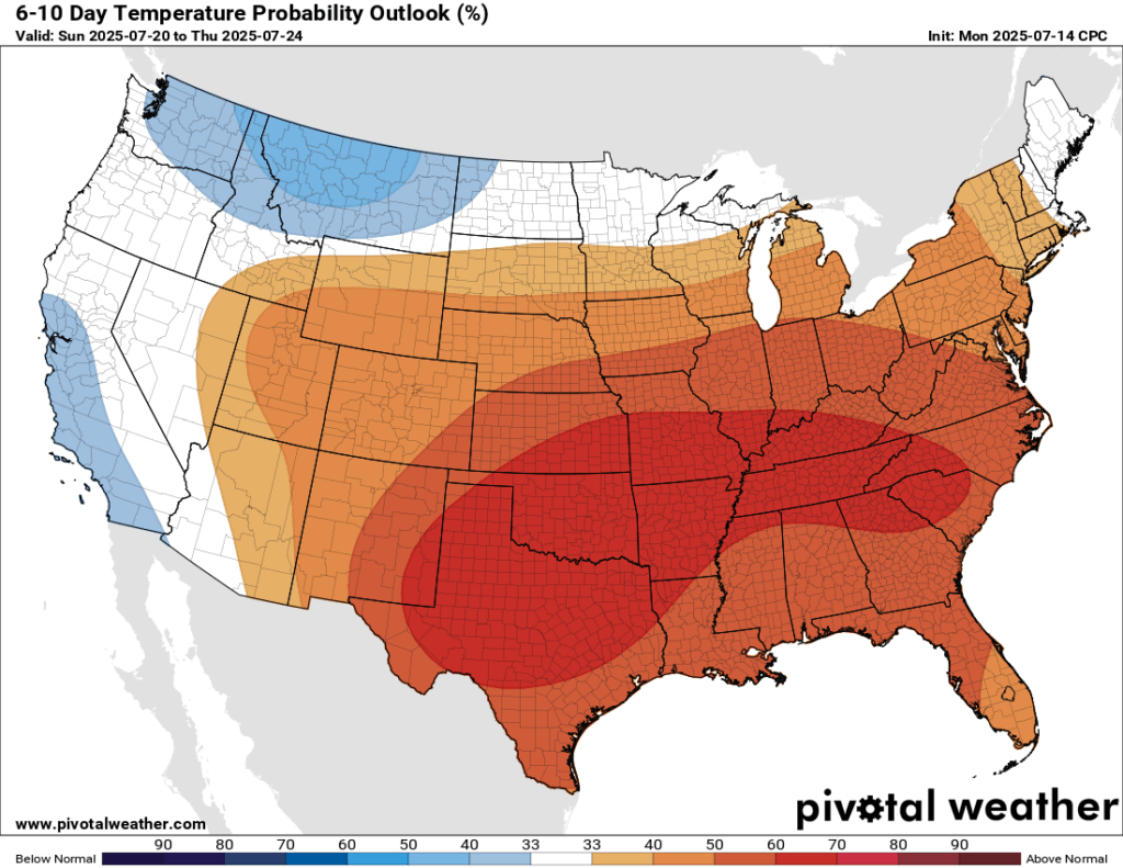
Texas should see above normal temperatures next week. (Pivotal Weather)
Sunday and next week
By Sunday or so, we should see sunnier skies and (probably) lower rain chances for awhile. Most of next week should bring highs in the mid-90s for much of Houston, so fairly typical weather for late July when Houston usually sizzles, albeit perhaps a few degrees warmer than normal.
In brief: Today’s post discusses today’s rain chances, and what kind of weather we can look forward to for the remainder of July. We also address the potential for a tropical disturbance to develop in the northern Gulf this week.
July has been mild so far
Don’t look now, but July is almost half over. Whether that is worth celebrating or mourning depends on one’s perspective. However, the next six weeks are typically the hottest period of the year in Houston. After a relatively mild start to the month so far—a majority of days have recorded highs of 95 degrees or below, the thermostat is going up. I think, from this point on for the remainder of July, we can expect the majority of days to reach 95 degrees or higher in Houston and for locations away from the coast. To be clear I don’t see a long string of 100 degree days. But we’ve reached peak summer, and it is going to feel like this outside.
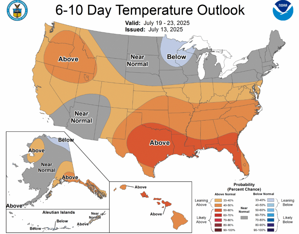
A warmer pattern is in store for the second half of July. (NOAA)
Monday
With a fair amount of atmospheric moisture and lingering low pressure, Houston will see a decent chance of showers and thunderstorms again today. Like for much of this past weekend, chances will be higher along and north of Interstate 10, but the entire region will at least have the possibility of seeing some storms. Once again, these showers will be decidedly hit or miss, with the heaviest hit areas picking up 1 to 2 inches of rain, and perhaps half the region seeing no precipitation at all. Skies will otherwise be partly sunny, with high temperatures in the mid- to upper 90s. Lows will fall into the upper 70s.
Tuesday
Rain chances drop back into the 20 to 30 percent range, with any showers likely to develop during the afternoon hours. Expect highs in the mid-90s with mostly sunny skies.
Houston should be solidly in the mid-90s this week. (Weather Bell)
Wednesday and Thursday
High pressure will likely hold sway during the middle of the week, and this should yield a pair of sunny days with highs in the mid-90s. With dewpoints in the 70s it will feel plenty humid outside, in case you were concerned about the air drying out. (I think this counts as gallows humor in Houston). Anyway, it’s gonna be summer sticky like always in Houston.
Friday, Saturday, and Sunday
Our weather toward the weekend may be influenced by a surge of tropical moisture (more on this below), but how precisely this will impact us remains to be seen. I think we’ll see a decent to healthy (30 to 50 percent) chance of showers on Friday, and perhaps some partly to mostly cloudy skies. This might cool highs off into the lower 90s. How long this cloud cover lingers into the weekend is not clear, but my guess is that most of Saturday and Sunday are probably mostly sunny, with highs in the mid-90s. Rain chances will be lower.
Next week
For now, most of next week looks sunny and hot, with highs in the mid-90s.
Tropics
My kids came home on Sunday evening and asked, “When’s the hurricane coming, dad?” This is how I know that certain social media out there are lighting up with rumors and discussion about a tropical disturbance that may develop into the northern Gulf later this week. This is an old frontal system that recently moved off the continental United States into the Atlantic Ocean, and will track across Florida in the next day or two. By Wednesday some sort of low pressure system should be in the northern Gulf, moving westward. So what happens after this?
The European ensemble model forecasts a low-end chance of a tropical depression forming near Louisiana on Thursday. (Weather Bell)
Our guidance is pretty split. Some of our best models don’t develop it at all beyond a tropical disturbance, whereas some of other models (particularly AI-based guidance) is a little more bullish in developing a tropical depression or tropical storm. If that happens, the most likely outcome is that this tropical system plows into southern Louisiana, bringing a high chance of rain there during the second half of this week.
As for Texas in general, and Houston in particular, most likely the major effects (if any) from this system will remain east of our region. However, with the disturbance not even developed, and potential impacts three to five days away, there is not much I’m willing to say for certain. We’ll continue to watch it, but our overall concern level is quite low at this time.