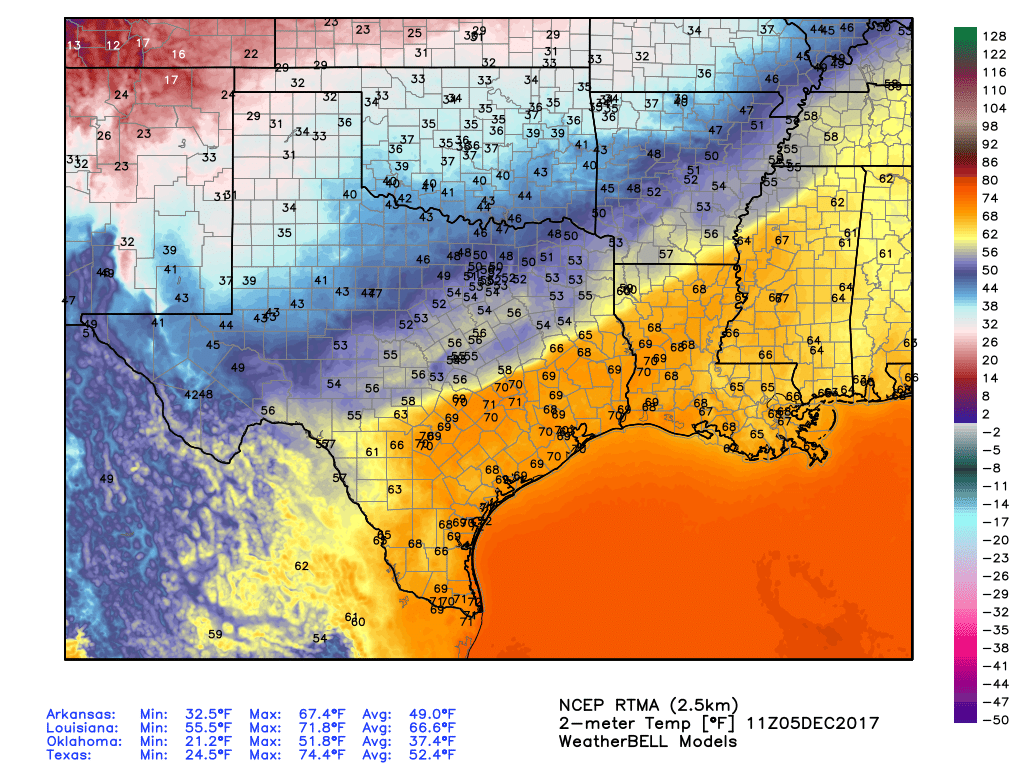
Temperatures this morning, just before sunrise, were about 70 degrees in the greater Houston area with essentially 100 percent humidity. This soupy weather is considerably warmer than normal for Houston, but it will now come to an end with the passage of a strong cold front Tuesday, and several reinforcing fronts over the next week. In short, winter has come to Texas.
Tuesday
The cold front is on track to move through Houston later this morning, likely reaching the coast by around noon, give or take an hour or two. The radar shows a broken band of light to moderate showers, with a few thunderstorms, accompanying the front as it sweeps down through Texas. I expect this pattern to more or less hold, and accumulations will be relatively low given the fairly rapid movement of the front to the southeast. Our weather will cool quickly with strong northerly winds blowing in behind the front.
Rain chances will return later this afternoon and evening, however, The dry air at the surface moving in with the cold front won’t extend very far up into the atmosphere, and due to the moisture aloft we are likely to see some continued light rain showers Tuesday night and on Wednesday.
(Space City Weather is brought to you this month by the Law Office of Murray Newman)
Wednesday
A cold, gray, winter day. Highs Wednesday may not reach 50 degrees on what is likely to be a dreary day for the region—which is perfect if you’ve been dying to wear your new winter coat. On-and-off rain showers could bring as much as 0.5 to 1 inch of rain on Wednesday across the area, during the overnight hours, and into Thursday morning. These showers should be light to moderate for the most part. Lows Wednesday night will fall to about 40 degrees in Houston.
Thursday
We should see another gray day, but lingering rain showers should end during the morning hours as drier air finally moves in throughout the air column above the region. Highs should remain confined in the 50s due to cloudy skies.
Friday, Saturday, and Sunday
The weekend looks pretty festive for December. Highs each day should be around 60, plus or minus a few degrees, with sunny skies. Nights will be cold. Beginning Friday morning, through Monday morning, a lot of the region will see lows in the 30s, with coastal areas remaining in the 40s. Right now, temperatures are forecast to remain just above freezing for inland areas, but it will be close. Here’s the National Weather Service forecast for lows on Friday morning:
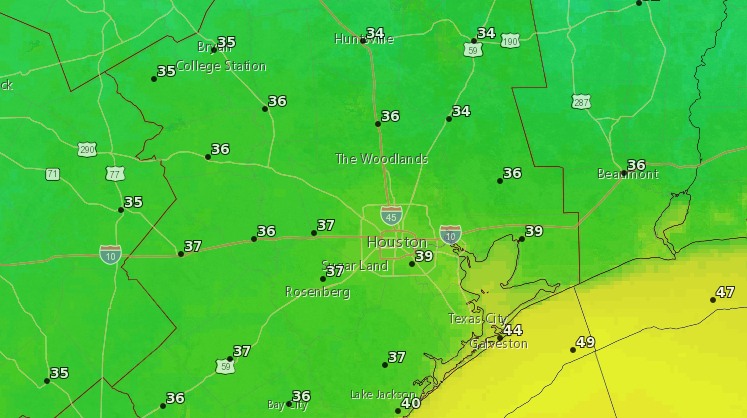
We’ll keep a close eye on the possibility of a freeze for inland areas as early as Friday morning.
How close are we to setting a new Houston annual rainfall record? It would be crazy to think that with 51″ in less than a week that we wouldn’t get there but it’s been pretty dry since.
That happened on October 3.
The annual record was passed in early October.
According to a quick search, the record got set on October 3. Anything since then is just raising it.
Dang..gonna have to wear sox with my sandals…my wife won’t be seen with me in public when I do that…at least they’re white…
Knee-high?
While it will be chilly, we should count our blessings! Chicago lows will be 16-25 F the next 5 days. And a low of 9 F in Minneapolis Friday!
I wouldn’t say “winter coat” because Houston doesn’t have winter.
But I will have to get the spring jacket out of storage, and might even be able to justify the leather bomber jacket if I’m out early enough in the morning.
When my mom (God rest her soul) moved down here in 2010, I remember watching Gene Norman’s forecast with her just before dinner one night. Gene said “Tonight, clear and bitterly cold with a low of 35”. To which mom, a veteran of 80+ northern winters, shouted back, “35 isn’t cold!!!”.