Summary: Cooler weather is in sight as we head later into the weekend. Before that, it will be warm to hot and humid, and there will likely be heavy rain and strong storms north and northwest of Houston on Saturday evening. If you’re traveling north and west toward Austin, Waco, or Dallas Saturday afternoon or evening, use caution.
Today
We hit 88 degrees yesterday in what felt like an early summer preview. Expect more of the same today, though we could shave a couple degrees off yesterday’s temperatures with more clouds possible. An isolated shower or storm is possible, much like we saw yesterday across the area. This would be most likely in the afternoon hours.
Saturday into Sunday
The forecast gets more interesting here. As of now, Saturday morning looks warm, humid, but otherwise fine. An isolated shower or storm is possible from late morning into early afternoon. By mid to late afternoon, storm coverage should increase. Here’s how we expect it to go right now.
Storms could develop in the Houston area, along and north or west of US-59/I-69 after 2 to 3 PM. I suspect those storms will lift north and west a bit and eventually line up robustly between about College Station and Huntsville. There is some signal within the models of training storms up that way, so rain could continue to repetitively cycle over the same areas a bit. Eventually, as the front plows south and east, all of those storms will come with it. That should sweep back through the Greater Houston area between midnight and 5 AM or so. It will continue to progress east and out of our area on Sunday.
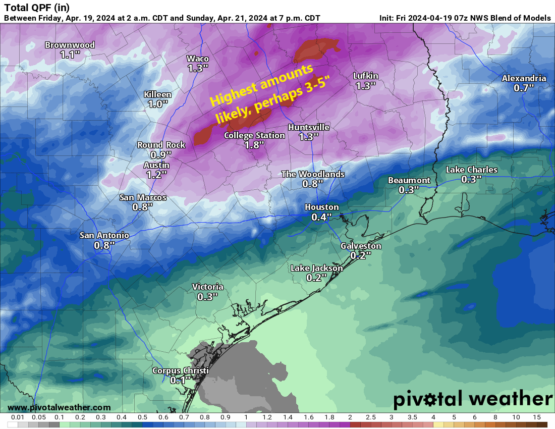
How much rain? I think we’re going to see a lot of variability, truthfully. From Houston south and east, probably a half-inch or less, unless the overnight storms pack more punch than we currently expect. Within Houston and the immediate suburbs north and west (Katy through Cypress and The Woodlands), we will probably see anywhere from a quarter-inch to an inch or more in an isolated spot or two. Farther north and west, along a line from about La Grange through College Station through Huntsville, rain totals will likely average 1 to 3 inches, and I would not be the least bit shocked to see someone end up with 5 inches or even a little more out of this. Flash flooding is a definite possibility up that way, and if you’re traveling between Houston and Dallas, Waco, or Austin tomorrow afternoon or evening, just be aware of this potential.
On Sunday afternoon, things should clear out, and the humidity will take a plunge.
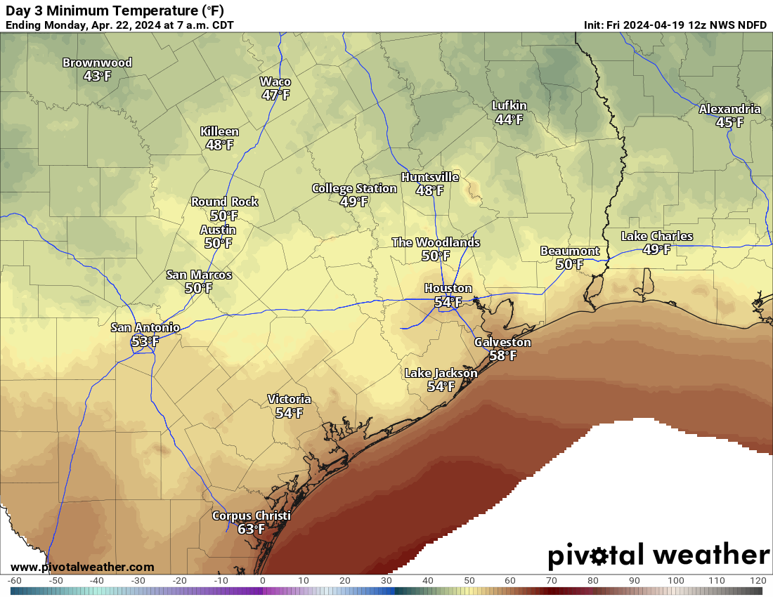
Saturday’s highs will again be in the 80s, with morning lows in the 70s. Temperatures should drop into the 60s with the storms Sunday morning before recovering back to near 70 degrees in the afternoon. It will be noticeably cooler and breezy.
Next week
Monday looks absolutely spectacular for late April. Expect lows in the 50s (or even a handful of 40s!), highs in the low to mid-70s, and plentiful sunshine.
Tuesday should be similar humidity-wise but a touch warmer with lows near 60 and highs around 80 or a little hotter. The weather pattern may get a bit more unsettled for late week. Along with very warm highs well into the 80s to perhaps near 90 later next week, each day will have a slight chance of showers or thunderstorms. Details are still TBD. I don’t want to speculate a ton on next weekend yet, with plenty of big athletic events on tap. I don’t think the MS 150 riders will be enduring much of a headwind, but the rest of the forecast is up in the air. More to come.

Thank you so much for your valuable insight. For those of us in Sugar Land, how heavy could the rain get between tonight and Saturday night? We have a massive outdoor event tomorrow and the forecasts are confusing to say the least :S Any insight you can share would be helpful. Thank you again..
According to the Weather Channel, the forecasted rain total from 6 pm, Friday, April 19th to 6 pm, Saturday, April 20th in Sugar Land is 0.27”. I hope that helps.
Best to watch local forecast throughout Saturday to what to expect prior to your event
So I think the first half of Saturday, other than like a quick shower, you should be good. The better chance for “you’re stuck inside” rain is probably after 4-6 PM, probably closer to 9 PM in Sugar Land. But as always, keep tuned in to see if anything should change.
The new NCEP long lead precipitation forecast dropped yesterday. For June through August, our region is expecting above normal rainfall. Maybe we wont have a volcanic summer and have a normal one instead? Stay tuned.
I think ‘Vulcanic’ is better here 🖖.
Seems like we are stuck in a past midnight to before dawn storms cycle (madrugada). I miss seeing those daytime storms.
Rinkos: To me this pattern of the midnight to before dawn fronts and storms has been going on for a few decades now. We seem to only get maybe one daytime front a year and I also miss seeing those fronts come through during the day, like they used to do back when I was much younger.
Given this setup and where we are in time, is it just as likely the 5” band of rain falls over Houston Metro instead up by College Station?
According to the Space City Weather forecast, at this time, it is not as likely that Houston will have 5” of rain as College Station may. I hope that helps.
Probably not. There was a little wiggle southeast today, but that placed it closer to Conroe than to Houston. If you live north and west of Houston, it’s possible you get some heavier rain than maybe you’re anticipating, but the real heavy stuff will probably set up just outside or north/west of Harris County.
What in the world is going on with the hi rez model forecasts? The FV3 Hi-Rez as a line of storms heading toward houston, and then when it hits the stalled front, instead of blowing up with the new supply of warm, moist air, it dissipates. Then it reforms on the other side of Houston!!
*has a line of storms
Yeah, this has been hinted at by some of the modeling through the week. I’m guessing it’s an instability thing…just the timing during the late night and potential for heavy, training storms north and west of the area…the atmosphere may get tapped out a bit. I’m skeptical too though, which is why we never really mentioned that as an outcome today. We shall see.
Soak in Sunday and Monday as much as possible because it will probably be the last blast of cool refreshing air until mid October sadly.