We are firmly in what I like to call a rinse and repeat cycle here in Houston. Showers and storms have been resilient much of this week, and with that in mind, I’d expect we see another round of storms today.
While not unprecedented, our current “cool” streak continues to lengthen. Yesterday marked five straight days below 90°, which hasn’t happened within August since 2001. If we manage to avoid 90° again today, it will be the first time in 20 years that we’ve accomplished six in a row in August.
Today
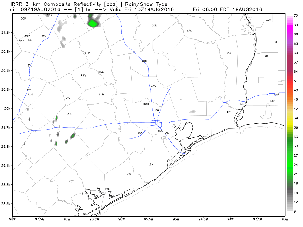
Radar is quiet this morning, with just a couple showers at the coast, perhaps even fewer than yesterday. Similar to Thursday though, with the sea breeze spreading inland from late morning into early afternoon, showers and storms should fire up over a good chunk of the area. We may see locally heavy rain as this happens. Also like yesterday, we could see locally high water on some area streets, especially those typically prone to flooding. It shouldn’t take a lot of rain to accomplish this. Storms will keep moving though and it shouldn’t rain in any one place for too terribly long. All in all, similar to Thursday, but perhaps a bit less coverage/intensity than we saw yesterday.
Temperatures today will be contingent on how quickly the rain arrives. We still managed 88° yesterday despite a good deal of cloud cover in the morning, but with rain arriving just after Noon, temperatures were cut down. So upper 80s to around 90° is reasonable for today. If rain arrives a little later, we could break our 90-free streak today.
Weekend
I’m going to recommend if you have outdoor plans this weekend that you keep tabs on the weather. If you have to choose Saturday or Sunday, I’d pick Saturday right now. Why? The weather Saturday at this point doesn’t look any worse than yesterday or today. In fact, some models continue to show a relative minimum (read: Not a 0 rain chance, just less than Sunday) of afternoon storm activity tomorrow.
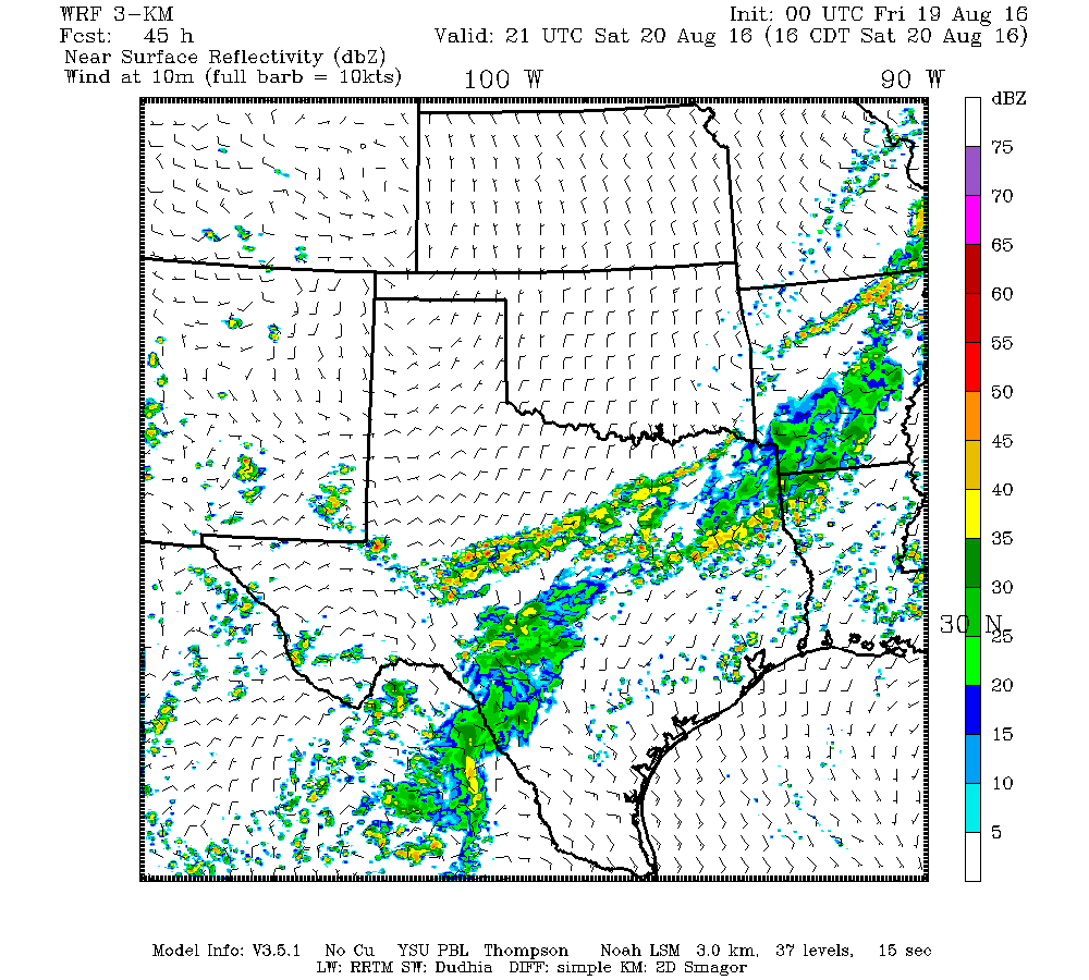
That said, an out of season cold front moves into North Texas Saturday night and Sunday. It won’t get to Houston, but the combination of it being nearby and continued bountiful Gulf moisture should allow for good coverage of storms Sunday afternoon.
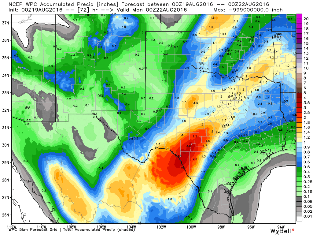
Word of caution: If you are travelling north, west, or southwest of the area this weekend, there will likely be some heavy rain and storms. In fact, there may be some flooding issues west of I-35, as the combination of the front, Gulf moisture, and tropical moisture from the Pacific is raising the risk of a pretty solid rain event in Hill Country or Brush Country.
Next Week
For those who would prefer a return to summer, there is good news. There will be scattered showers and storms again on Monday, but by Tuesday, Wednesday, and Thursday, the daytime thunderstorms around Houston should be less aggressive. No, the rain chance doesn’t drop to zero (it almost never does in Southeast Texas anyway), but it lowers considerably from where it’s been this week. Of course, that means hotter temperatures and a return to the 90s likely. I wouldn’t rule out some chance for mid-90s next week, but stifling upper 90s to near 100 seem unlikely for awhile.
Tropics
Fiona continues to march along in the open Atlantic.
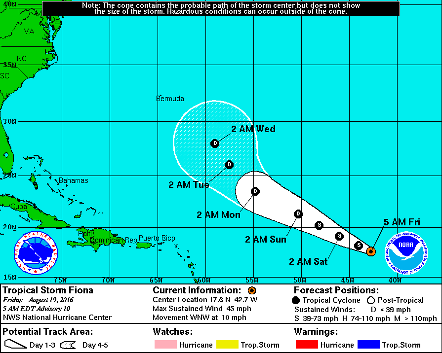
Winds are 45 mph, and Fiona is expected to weaken over the next couple days.
A system behind Fiona was designated yesterday as “Invest 99L.” We’ll keep an eye on this the next 7-10 days or so. Weather models vary wildly on where this goes. Right now, I see two likely outcomes over the next week to 10 days: First, is that this thing could find a weakness in the upper air pattern over the Atlantic and find its way north into the open water behind Fiona. This scenario is supported by the European operational model, which has consistently shown it doing this for several days now.
The second plausible outcome I see is that this continues to march west and ends up near the Caribbean islands in 7-10 days. If that’s the case, all bets are off, though the upper air pattern predicted over Texas in 10 days time isn’t exactly ideal to track a storm into the Western Gulf. So basically, I’m not worried right now (and you shouldn’t be either)! It’s a long way off, it hasn’t even formed yet, and there’s a lot that can and will happen between now and next week, so we’ll just keep tabs on it for now. We’re in the heart of hurricane season, so you can expect more systems to form out there. Rest assured, we’ll be on top of them all, and if it’s something we need to worry about, you will know quickly.
We are planning to drive to Austin this weekend (leaving Saturday morning, returning Sunday afternoon). Should we anticipate heavy rains between here and there? We have three little ones excited to visit their cousins, but don’t want to take any chances with flooding.
I don’t think we’re going to see the kinds of storms that are going to cause serious flooding in Austin. Just drive cautiously during the heaviest rains and you should be fine.
This cool spell may be the result of Al Gore’s recent appearance in the area.
I’m getting the vibe that given the upper air patterns over the Gulf of Mexico, unless we get a “homegrown” system, the season may be over already for the TX coast.
Your thoughts???
Thank You Sir.
No I definitely wouldn’t say that. We have another five weeks or so that we really need to be concerned about in regard to potential hurricane activity.
Eric, I’ve been looking at the water vapor imagery. It shows a deep layer moisture tap off of the Pacific that is located across the central and northern parts of the state. Over the weekend and into Monday (my fellow hobby mets and I think) the upper level high pressure ridge will keep the best moisture channeled over those areas. If we’re right, it will mean that the chances for stronger storms will be to the west of the forecast area. Still, would it be wise to monitor the situation? What issues will there be with t-storms in SE-Texas?
Isn’t it just possible that the forecast models aren’t handling the ridging to the north of 99L correctly, Eric? I mean, many models do have a northward bias, don’t they?
Eric, I think the GFS will continue to trend west, underestimating this Bermuda High. In the end, it may have it slam into the Texas Louisiana border.