In brief: The word for the weekend is windy. We’ll see 30 to 40 mph wind gusts at times through Saturday, before things calm a bit by early next week. The weather will turn unsettled, with variable chances of daily showers and storms well into next week. We’ll likely see isolated activity today and slightly better rain coverage on Sunday and Monday.
Today
Hold on to your hats, folks. Wind gusts started picking up yesterday afternoon, up to about 30 mph or so. We will likely see that again today, perhaps most of the day this time. Wind will be the most noticeable element over the next few days. A few showers or even a thunderstorm are possible later this afternoon, with the highest chances north of Houston. Highs will be into the 80s once again.
A couple showers or even a thunderstorm will be possible into the first half of the overnight hours tonight.
Saturday
Saturday just looks like another windy, warm, humid day. Winds should be at their strongest on Saturday, with gusts as high as 35 mph or even stronger over the water.
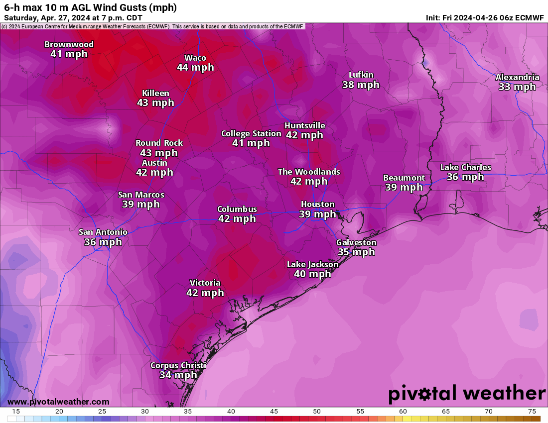
Highs in the 80s, lows in the 70s.
Best of luck to any IRONMAN participants or MS 150 riders. We think Saturday will have that solid southeast or south-southeast (mostly) tail wind, at times 30 to 40 mph. For those less seasoned MS 150 riders, please exercise caution with some of the gusts you’ll experience.
Sunday and Monday
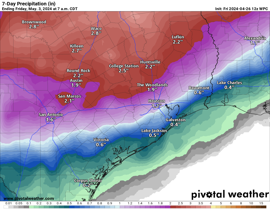
Winds will slowly subside on Sunday, but we should still see plentiful 20 to 30 mph gusts. It’s beginning to look as if a line of thunderstorms will develop in Hill Country in the predawn hours Sunday, sweeping east and southeast while weakening. They may fire back up as they approach the Houston area in the afternoon hours. Details on this are still somewhat TBD, but a couple hours of heavy rain, gusty winds, and lightning are a good possibility anywhere in the area Sunday afternoon. Severe weather can’t be entirely ruled out, but it’s not highly likely for Houston.
This will be something to watch for MS 150 riders, as the storms could be better organized crossing I-35 and approaching the Brazos Valley and College Station. It will have to be a Saturday or Sunday gametime decision in all likelihood.
Monday will see additional chances at scattered showers and storms. Whether it’s hit or miss activity or something more widespread and organized remains to be seen.
Another round of highs in the 80s and lows in the 70s are expected both days.
Rest of next week
We will likely continue with daily shower and storm chances into next week. Some days will have better rain chances than others, but because there’s a lot of quick moving traffic in the upper atmosphere, it’s a little difficult to try and time when a disturbance will hit and produce storms here. The good news is that the severe weather risk continues to look mostly north of our area. We will continue with fairly stable temps and high humidity, with highs in the 80s and lows mainly in the 70s.

😬 Yikes! Visiting Houston next week for my daughter’s (outdoor) graduation from Rice… Any thoughts on what the weather will be like on Saturday night (May 4), 5pm- 9pm? Or too early to tell?
BTW – You came highly recommended by many Rice parents and I’ve relied on you for 4 years during her stay – THANK YOU! (Any chance for starting an off-shoot to cover Boulder, CO? Grad school coming up next, and I’ll miss you! Snow and blizzards will freak me out! 😂) Carmela
You can check our sister site “theeyewall.com,” where we occasionally touch on national stuff, including Colorado. I also recommend the guys at weather5280.com for Denver/Boulder! Thanks for sticking with us! Anyway, it’s a bit early to get too confident in Saturday, but as of now, I wouldn’t really expect rain, though I can’t promise there won’t be a chance of a passing shower. Rain chances look a bit higher Thurs-Fri than on Sat. We’ll see how it progresses this week!
Thank you! I’ve already subscribed to The Eyewall because I have family on the East Coast – THANKS for the Colorado recommendation!
Ah, April. The month when we gardeners find out which plants we put in the ground are sturdy enough to survive potential tropical storm winds.
At least it wasn’t as bad as three or four years ago. The winds were consistently so bad that April that the persimmon I planted ended up growing sideways like you see the trees in high mountainous areas do.
These winds do make it feel nicer outside; don’t feel the humidity as much. Similar to coastal regions I’d say. When can we expect one of those all day rain events? I need a break from my kids sports and a rain-out can help with that, lol.
Wondering if there will be any sun on Saturday. Guess tomorrow will tell!
Maybe it will actually rain here Sunday. I’m not hopeful given past fronts.
Do you expect to activate the SCW flood scale for the Metro by Wednesday, or will it be later in the week?
Why would they?
No expectation to as of now, but we’ll be watching things.
Hold on to your toupees, gents.
More a risk of scalp wind burn in my case…
Dear Eric,
Will my Menil park bday hang be ruined on Sunday?
Thx
Maybe if it rains. Good luck!