With rain and storms daily, Houston has held up pretty well, particularly considering the terrible situation in Louisiana. Yes, there have been minor bouts of flooding in parts of the area, but the rain has moved quickly enough and sporadically enough for us to escape major problems to this point. And for the first morning this week, we don’t have any Flash Flood Watches in the area to tell you about.
We’re beginning to see this pattern finally erode a bit.
Today & Friday
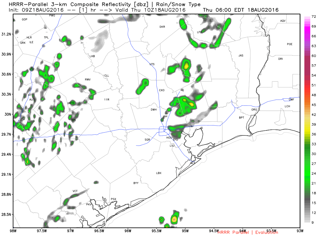
The transition from this widespread daily thunderstorm pattern to something we’re more familiar with in summer in summer is underway: Morning coastal showers spreading inland with the sea breeze off the Gulf in the afternoon. You can see a radar forecast for today below:
Basically, I would expect gradually fewer showers today and tomorrow compared to how the earlier part of this week has gone. That said, we’re still probably looking at a slightly stormier than usual pattern for August, just not as busy as it has been for much of the week.
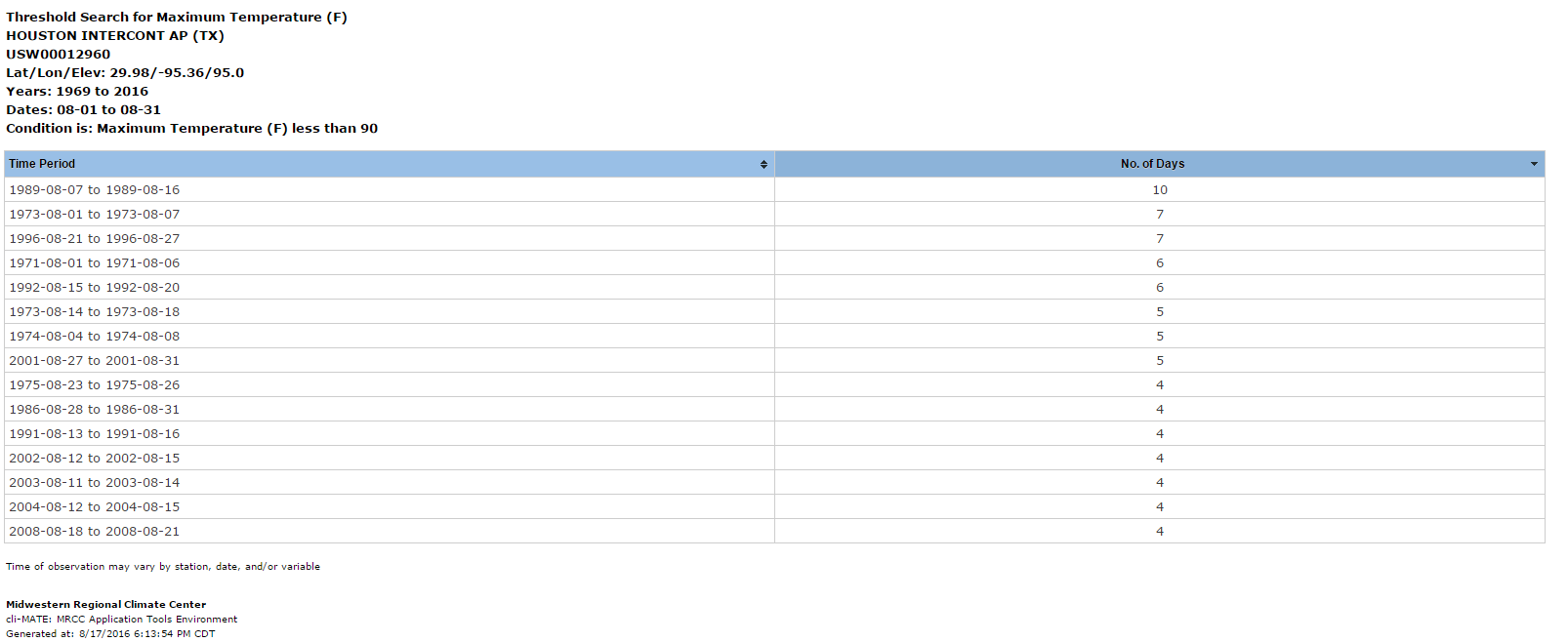
Temperatures, as Eric noted yesterday have been a somewhat refreshing reprieve from our typical sultry weather in August. We’ve gone four straight days below 90° for a high (89°, 86°, 82°, 83°). The last time in August that we saw 4 consecutive days below 90° was 2008. The last time we did 5 straight was back in 2001. So to have a stretch of “cool” weather like this in August is uncommon. Hopefully you’ve been able to sort of enjoy it, despite the rain.
Temperatures the next couple days will be contingent on cloud cover and how quickly storms re-fire in the afternoon. Given clouds this morning, I think we’ll stay south of 90° one more time today. Tomorrow stands a slightly better shot at 90°, but even that will be a close call.
Weekend into Monday
For a minute yesterday, I thought Saturday might end up being a dry day, but trends have shifted toward slightly increasing storm chances. Now, Saturday looks like today and tomorrow (morning showers closer to the coast, a better chance spreading north into and through Houston in the afternoon). This continues Sunday, but another rather early season cold front will push into North Texas (low 80s continue in Dallas). That could mean more numerous storms on Sunday, especially north of I-10. Temperatures will be held down depending on storm coverage. With more storms than expected, we’ll see upper 80s for high temperatures, but with fewer storms, we might see low 90s. For now, we’ll call it “around 90,” and I’ll take another look at this for you tomorrow.
Right now, if you have to make outdoor plans this weekend, I’d lean toward Saturday versus Sunday.
Storm chances continue Monday, but by Tuesday onward, we should see a sharp drop off in stormy weather and a much drier weather pattern return.
Tropics
Tropical Storm Fiona formed yesterday afternoon, becoming the sixth named storm of the 2016 Atlantic Hurricane Season. For Houston, no worries at all, as Fiona should stay well out to sea. The storm has maximum winds of 45 mph this morning.
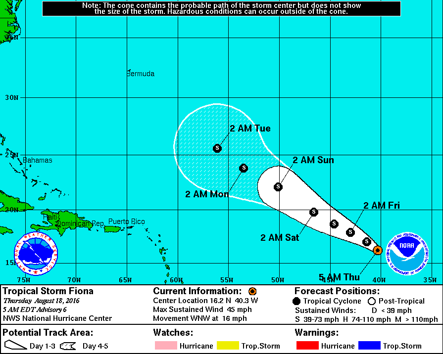
Fiona is expected to max out today or tonight around 60 mph before dry air and wind shear take a toll. There is likely to be another tropical wave behind Fiona that will develop as we go into the weekend or next week. Though that storm has the potential to be stronger than Fiona, as of now, it is also likely to stay out at sea. Still, we’ll keep an eye on things. The Gulf remains nice and quiet.
Posted at 6:30 AM by Matt
Hey Matt, we’re going to be in San Antonio on Saturday for a wedding. You think any rain chances over there?
Unfortunately, there’s definitely a chance. Probably scattered storms in the area (unsure exactly where, obviously…but nearby). May even be some overnight storms there as a front tries to approach. Hope for the best, but expect some weather.
The fact that this weather pattern reminds me of 2008 makes me a tad nervous. 2008 was the year of Ike and Lord willing that won’t happen this year.
You said it, Lisa. And, even more frightening, CenterPoint Energy says they have fewer resources to deal with a major storm strike than they did back in ’08. Company officials say that if a major storm strike does occur in the Houston region, some households might not see power restored until 2017!
Matt, Lisa may have something there. Are we in a weather pattern that is a dead ringer for 2008?
Get ready to be more nervous, Lisa. NHC is tracking a tropical low called Invest 99L. It is being watched closely because it is expected to track all the way westward into the Caribbean. None of the forecast models at this time are showing any recurve? Matt, you have anything to say about it?
Hi gang. I will talk a bit about this tomorrow AM. But a couple things. 1.) Colloquially, it may be reminiscent of 2008, but meteorologically there are not a lot of similarities right now at all. 2.) Don’t fret over the power situation. No company is prepared for a major storm. But they would receive massive quantities of help from fellow utility companies, so the resolution time for power outages wouldn’t be any worse than it would be elsewhere with a major event I don’t think. 3.) Fiona is not an issue, but yes “99L” will be worth watching. There are actually a lot of models showing it recurving back out to sea, including the European model (considered one of the best). I’m not particularly worried about it for the Gulf (I personally feel the pattern forecast in 2 weeks over Texas is favorable for keeping storms away), but it’s also 2 weeks out so it’s worth keeping a side eye on.
We’re getting to the time of year where the tropics are going to get active. There are going to be more storms. Just remember that the vast majority never impact us. Trust me, we will be loud and clear when we think it’s time to start paying very close attention. No worries for now. I’ll talk some more tomorrow about it.
Looks like Lyondell on 225 got nailed with a lightning strike – plenty of black smoke pouring out of their flare around noon. Black smoke would indicate no steam to the flare, meaning their boilers were down either directly from a strike or from a power outage.
Noticed a lot of black smoke flaring from the Ship Channel earlier…hadn’t heard specifically what it was though. Looked nasty.
Lyondell (er, uh “Houston Refining” now) definitely. About a mile or so from my plant. The flare was on the west side of their plant, near one of the coker units (the coker that caught fire in April?). They got steam to the flare maybe 2 PM.
Last I heard leaving work it was definitely a lightning strike.
Any chance that all of the recent rainfall may have broken the back of summer? I’m hopeful that the high soil moisture levels, combined with shorter days and a lower sun angle, could mean we’ve seen the last of the upper 90’s for this year. Thoughts?
I think there’s a chance, but I wouldn’t rule out this being a temporary diversion from summer. Looks like a drier pattern sets up over Texas in 7-10 days, and with that perhaps another ridge setting up in the Rockies. Any shift east in that, and you get some solid heat. At best I’d say 50/50 right now that we’re done w/ upper 90s. But that’s better than it usually is in August!