Here’s an afternoon update based upon the latest model guidance for the tropical system, Invest 93L, now located in the southern Gulf of Mexico. A hurricane hunter is investigating the system this afternoon, and it may be upgraded into a depression or storm later today.
It’s best not to think of this system as a classical tropical storm or hurricane, but rather, as my colleague Matt Lanza puts it, “an atmospheric river” of moisture flowing from the south into the United States. In other words, we’re dealing with something that’s going to bring a lot of rain to someone along the Gulf of Mexico coast. Consider the following forecast, from the European model, for precipitable water values on Wednesday night.
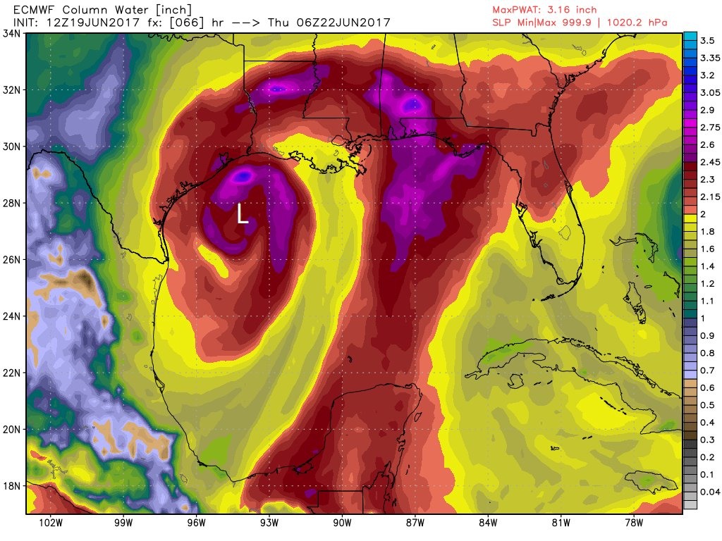
Any value above 2 inches of precipitable watyer is quite high, and you can see that although the center of this storm is near the Texas coast, it is funneling a massive amount of moisture from the Gulf of Mexico into Louisiana. That spells a heavy rainfall event.

I write that to stress the following: It’s important not to focus on the “center” of this storm like with a classic hurricane. This is because the main action (i.e. rainfall) will likely be considerably to the east of the storm’s center. With that caveat, here are the latest track models (with the addition of the 12z European model) showing a range of landfall locations from the upper Texas coast through Louisiana.
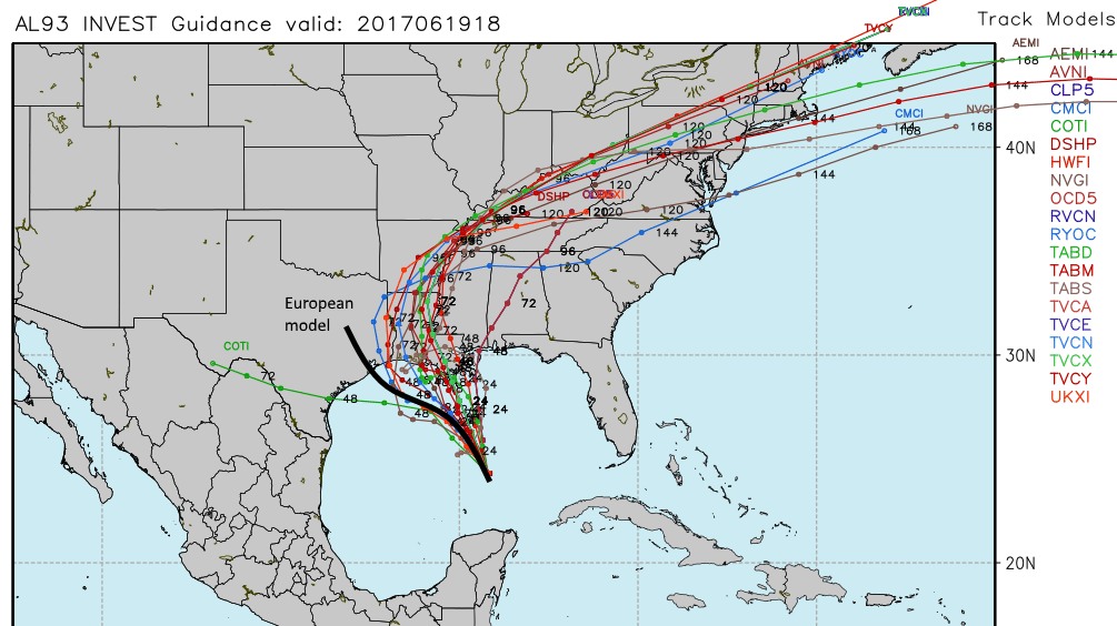
What does this tell us? Clearly a major rainfall event is coming to the Gulf coast this week. However at this time the odds favor it occurring over Louisiana or to the east, rather than over the greater Houston area or East Texas. If the center does come ashore near Houston, as the European model suggests, that will create some stronger sustained winds, but I don’t think they’ll be strong enough to cause widespread damage given that this system is unlikely to reach hurricane strength.
Note that this forecast is not in any way set into stone, it’s just representative of the best available information as of 2:30pm CT on Monday. We will remain on top of this forecast.
Posted at 2:30pm CT on Monday by Eric
Are you anticipating any impacts for air travel on Wednesday out of Hobby or IAH based on this?
Do you think we will receive any rain at all with this system? From various models it seems LA is going to be hit the hardest. Some rain would be welcome as it would provide some relief to the heat.
Meg
These folks are getting worried I bet.
https://en.wikipedia.org/wiki/2016_Louisiana_floods
Our weather service at work is still calling for a landfall around Anahuac. Not sure why given the model guidance.
Glad you guys are back online tonight!
Any risk of widespread power outages?