Some active weather is likely to continue over the next 24 hours, so we’ll get right into that before talking about a mostly nice weekend to follow.
Early morning Friday
Radar as of 5:40 this morning, shows minimal amounts of showers around Houston. There’s some rain well to the north of Conroe that is falling apart.
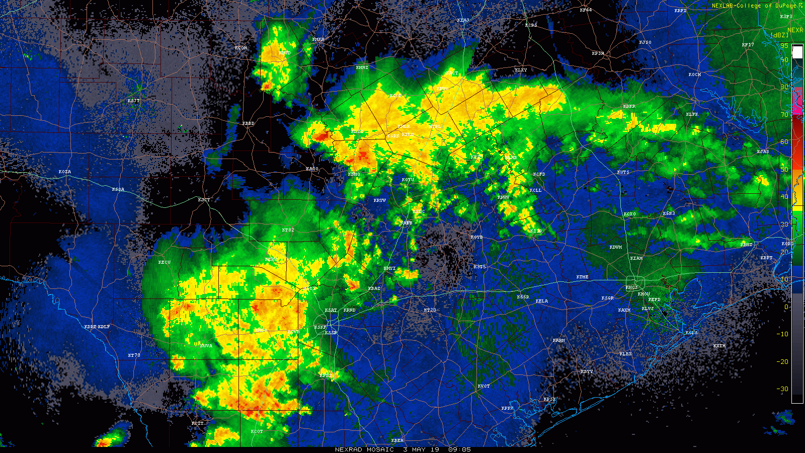
Scattered showers and storms were pressing east of Austin, more toward the Brazos Valley. Heavier rain and storms (non-severe) in San Antonio were sliding east toward Victoria and places west of Houston. Over the next few hours, these showers will gradually migrate toward Houston, but for the most part, our early morning looks fairly quiet.
Friday late morning & afternoon
Weather modeling has been some kind of inconsistent over the last couple days in terms of what and where with rainfall. So to some degree, this leaves us flying partially blind today. We can tell you a couple things with confidence: First, there will be plenty of moisture available for storms today. This is probably the most we’ve seen all week, so it should mean coverage of storms today will be at their highest of the week for Houston. Second, we need a trigger, and with numerous boundaries in the area and more coming from the San Antonio area, that should be enough to get showers and storms going later this morning and this afternoon.
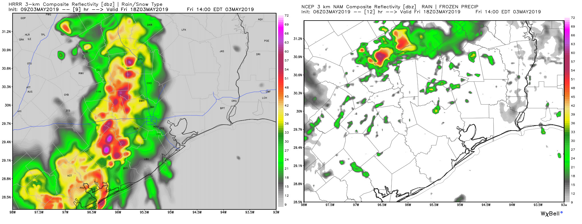
What we cannot tell you with much specificity, and what is naturally most frustrating to us (and you I’m sure) is exactly where and when the heaviest rains will occur. The image above is a sample from two short-range, high resolution models we look at each day. They are valid for the same time: 1 PM this afternoon. The HRRR (at left) shows an organized heavy cluster of storms. The NAM (right) shows scattered showers. I am leaning toward the HRRR idea right now, but basically at this point, the best advice we can give you is to bring an umbrella and be ready to potentially deal with some storms and heavy rain from late morning into this evening.
In terms of severe weather, it is possible we see some strong winds or hail, but the biggest concern with these storms will be heavy rain and localized street flooding. Any storms could produce rain rates of 1-2″ per hour or more which, if over one place, could lead to some street flooding.

Tonight into Saturday morning
Finally, tonight, a cool front is going to slide across the region. This may allow for one more round of heavy rain and thunderstorms overnight for much of the area. Again, we can’t delve too deep into specifics, except to say there are good storm chances overnight. By 7 AM Saturday, most of this activity should be along or east of I-45 and moving toward Louisiana. This will mean improving conditions Saturday morning from west to east across the area. I can’t promise 7-8 AM will be dry in any one place, but the odds for dry weather will increase as the morning progresses.
Saturday afternoon & evening
The rest of Saturday should feature warm, humid conditions and hopefully a fair bit of clearing. We’ll top off in the low- to mid-80s. Chances for additional showers look low on Saturday afternoon.
Saturday night actually looks great and borderline comfortable right now, with low temperatures perhaps down into the mid-60s in spots, a bit cooler than we’ve seen this week.
Sunday
A fine day is expected with a lot of sunshine, but it will be hot. Look for upper-80s in Houston. It won’t be extremely humid, but it won’t be especially comfortable either.
Monday
Look for another mostly nice day. There could be a few showers that pop up in the afternoon, especially west of Houston, but no serious weather is expected right now. After morning lows in the upper-60s, expect high temperatures to top off in the mid-80s.
Beyond Monday
The weather pattern should turn much more unsettled after Monday. An abnormally cool air mass is going to drop into much of Texas later next week, setting up a battleground that may unfortunately be close by the Houston area. Details are impossible to discern right now, as weather models differ on timing and placement of various features. But there is probably a very good chance we see several rounds of rain or storms later next week. We will be able to tell you a bit more about this on Monday.
I got rained on during my evening walk last night – well, 2 drops over 2.5 miles. That’s 0.8 drops/mile, but more than I’ve seen recently.
Hoping for a good 2″ between today and tomorrow.
🙂 Move to The Woodlands — we got 3-4 inches in the past 24 hours 🙂
Looks like you got your 2”…unless you are closer to Tomball who got an average 3-5” with 10 foot rises in the rivers…
Trouble reading your e-mail today and other days because of the massive size of the embedded graphics, which reformat the text columns as well, so that the message has to be scrolled sideways to read completely (Outlook on Windows 10). Even maximizing the window does not fit it all on the (17″)
screen.
I forwarded mine to Outlook, and I see what you’re saying. Unfortunately, it looks like this is an Outlook issue that’s I am guessing is kind of difficult for us to solve. I will inquire about anything we can do though to see if that can be minimized. Thanks for the head’s up.
I use gmail and it comes through just fine…. and I use Chrome as my browser, and it also looks fine there… could be the email platform you use or if you’re using Explorer… especially the newest version… they always seem to present the most problems.
No problems with the email in Gmail on Chrome on Android phone.
Here’s a link to a live lightning map as the sog approaches Houston.
https://www.lightningmaps.org/?lang=en#m=oss;t=3;s=0;o=0;b=;ts=0;z=8;y=29.213;x=-96.1556;d=2;dl=2;dc=0;
Just heard on the radio these are producing tornadoes, caused alot of damage in La Grange. Seeing how Houston doesn’t have sirens, do we need to be concerned about this?
thanks for the lightning map….great info….
Flying into Houston tonite – when will the worst weather be through our area ?