I will jump into the latest on the potential for a tropical depression or storm named Barry in just a moment. I did go extremely in depth on where we stood last evening with regard to Barry, which you can check out as well. First, we do still have some important weather (heat) to get through before that.
Today & Wednesday
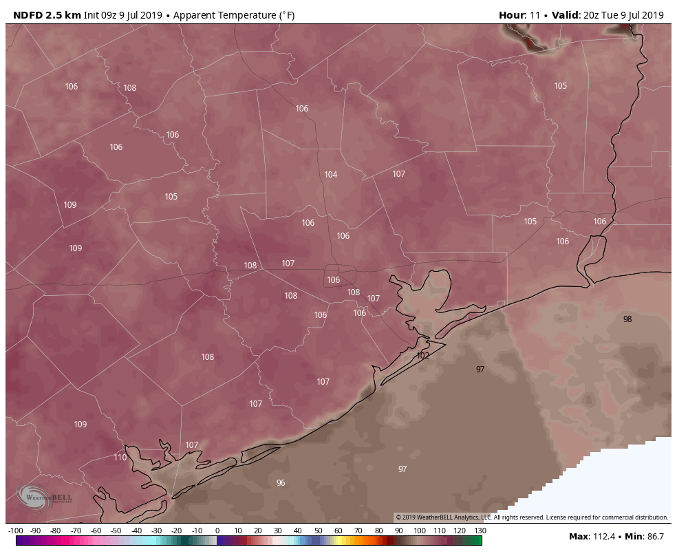
Heat and humidity will dominate today once more. We should shoot for the mid- to upper-90s again this afternoon. Look for potential heat advisories again this afternoon.
Exercise heat precautions today, stay hydrated, and try to stay in air conditioning if possible in the late afternoon. After some noisy, soaking storms in northern parts of the metro area yesterday evening, we could again see a handful of showers again today, though coverage and intensity should be a bit reduced.
Wednesday looks even worse with high heat and humidity. Expect upper-90s and risk for heat advisories again. There could be one or two showers around but nothing more.
Thursday
We should begin to feel some influence from the potential tropical depression or storm in the Gulf by Thursday, which would just mean a few scattered showers or storms at this point on Thursday afternoon. Otherwise, it will be hot and humid with solid mid-90s if not a little hotter.

Friday, weekend, and potential for Barry
The link in the first paragraph will get you to my in depth post from last night. I’m not going to repeat a whole lot this morning, but here’s where we currently stand. We still have a significant degree of uncertainty regarding the future of Invest 92L/future Barry.
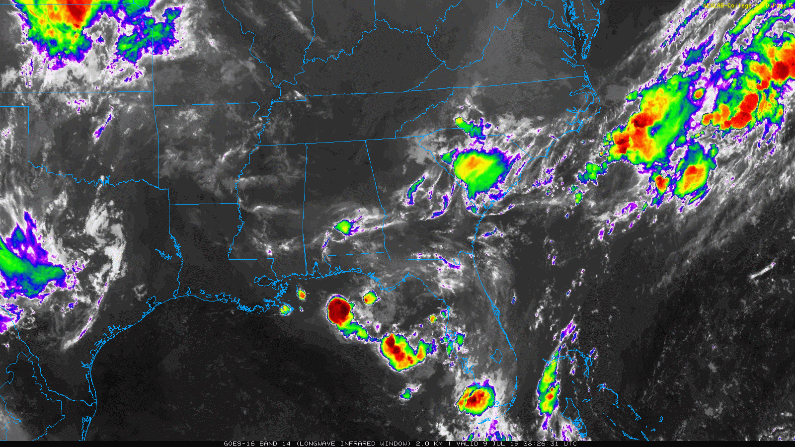
The one sentence summary: Thunderstorms are developing in the northeast Gulf that will ultimately help determine where 92L goes and how strong it becomes, and while overnight guidance did shift back more to the east (focused in Louisiana), there remain a number of potential outcomes we should be prepared for.
The National Hurricane Center continues with an 80 percent chance of development over the next 5 days somewhere in the northern Gulf.
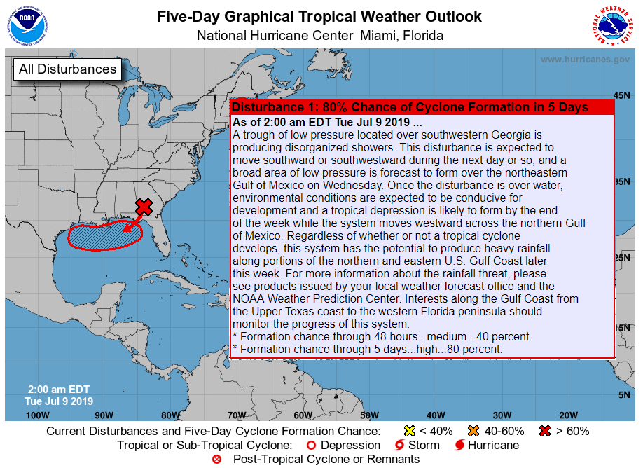
Just to clear up any misconception about NHC graphics, the hatched red area on the map above indicates where development could occur, not a forecast track. This risk is mostly unchanged vs. 12-24 hours ago.
The disturbance that we are watching is somewhere between southern Georgia and the northeast Gulf this morning. Thunderstorms have recently begun firing, and the question becomes, out of this mess, where will the action focus? That will allow us answers as to where 92L/Barry ultimately goes.
So has anything changed overnight? As it relates to what we should be doing in preparation and what we should expect, no, nothing I would say has changed: There is still a significant amount of uncertainty around this system and there remains potential we are impacted by it this weekend in Houston.
But there were some hints that perhaps model guidance has begun to halt or reverse the western shift we saw yesterday. For those that look at models, many have focused on the European model, as it has been the strongest of all the reliable guidance, bringing a borderline hurricane into western Louisiana or eastern Texas since Sunday night. That model shifted markedly east with things overnight, more toward Central Louisiana with track, minimizing impacts in Houston. Why? I believe a slightly deeper/stronger trough in the Midwest is exerting more northward “pull” on the system, allowing it to end up farther north over time.
More importantly, the European ensemble spread (50 runs of the Euro with different initial conditions) generally shifted a little further east as well. Worth noting, the GFS model continues to insist this will barely develop. Now, I have done this long enough to know that this could easily swing back hard the other way this afternoon when that data is updated. This is why we caution you about focusing too much on individual model runs. The takeaway here is that model trends overnight were not discouraging, but until we get a true center for models to focus on, don’t fall in love with any one model outcome.
With all that said, the NWS rainfall outlook has shifted a bit further east as well, with the 5 to 15 inch bullseye now centered over the Cameron and Lake Charles areas of Louisiana.
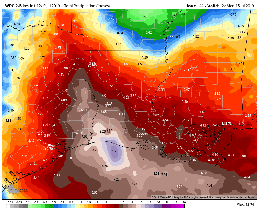
I’m not intending a pun here, but it is important to remember that this is a very fluid forecast, and as the system organizes and guidance comes in line, we will see this rainfall forecast shift. Bottom line, travel along the Gulf Coast Friday and especially Saturday will be difficult east of Houston. Scattered storms are possible elsewhere too.
So Matt, what is the forecast for Houston Friday through Sunday? Again, given that we don’t know for sure where 92L will go, we can’t say for sure what the forecast will be. But I try to be a reasonable person, so let me offer you three possible outcomes, in no particular order at all.
Scenario a.) Overnight model guidance, specifically off the Euro accurately shifted things east, and the system comes ashore in central Louisiana: Houston would be extremely hot and mostly dry. High temperatures would be in the upper-90s to near 100° and storm chances would be minimal Friday and especially Saturday.
Scenario b.) The GFS model is generally correct, and 92L will come more due west, disorganized: We would see high temperatures in the upper-80s to low-90s all weekend with higher end daily storm chances, capable of locally heavy rainfall. That would probably yield 1 to 3 inches on average, with higher amounts possible.
Scenario c.) The Euro and GFS trend toward one another or the center forms further south in the Gulf today and tomorrow, allowing a more westward track toward southeast Texas rather than central Louisiana: We would see tropical depression or tropical storm type impacts Saturday and Sunday in the Houston area. That would include wind, waves, and widespread heavy rain in this scenario.
All three of these scenarios or some hybrid of a couple are completely plausible right now. I don’t expect a ton more clarity this afternoon, but I do expect a decent boost in forecast confidence by tomorrow morning. I’ll update with the latest later today.
I appreciate the info; especially the no-nonsense, no-hype, this is what we know now view.
You can’t predict where it will go when it hasn’t yet developed enough to know what the initial conditions are.
All we can do is keep abreast of your posts to get an idea of what “Barry” is doing and what might happen once it gets organized or not.
Thank you very much. It is a relief to know that your posts are very trustworthy and that I can use them to figure out what to do. Especially in light of the “chicken little” hysteria on the web.
I know it’s early, but are you expecting any storm surge in Texas? If so, any estimates on the size of the surge?
No storm surge unless the system hits us head on or to the west. Anything east will lower water levels
The weather service we use at work favors scenario D – hitting western Louisiana as a 60 MPH tropical storm. For us that is pretty much like scenario A.
Anybody got a scenario E?
E F G.
Doesn’t form. Curls into Alabama. Goes further south and becomes a major hurricane.
H. – Katy evacuates.
What specific recommendations do you have for Katy residents? Could you layer on customized suggestions for the people of Katy based on the 3 scenarios you laid out?
Best to just go ahead an evacuate now.
True. 60 miles or so inland. Storm surge along the Brazos could be nuts.
You know what, this isn’t funny anymore, since a great many people flooded in Katy during Harvey.
😥
Thank you, once again, for the best weather forecast we have.
In scenario C, you suggest that if it comes towards Houston it will be as a tropical depression or storm.
Does that mean you think it won’t hit hurricane force, or that it will start to degrade before it gets to Houston in that scenario? And if so, why?
Don’t read into it too much. I don’t think it will hit hurricane force, no, but as I’ve noted several times this week, that possibility can’t be entirely written off. But nothing right now suggests that’s a serious worry.
Is a 6 day trip to Bermuda Beach in Galveston Friday-Wednesday severely threatened? Or worst case just some possible heavy rain during the weekend?
Wondering about this too. We have a house rented for Wed-Sun. Looks like it won’t be bad, just rainy, so I guess we’ll pack some rainy-day activities for the kids and hope for breaks in the rain.
Your schedule looks better for avoiding rain at least!
Matt, the three scenarios are very helpful in illustrating just how much uncertainty exists while also helping us wrap our head around how bad it might or might not be. Thank you for that.
The current National Weather Service 7-day cumulative rain forecast is for 3.7 inches in downtown, 3.7 inches in The Woodlands, and 5.1 inched in Galveston. But as you say, this is a low confidence forecast.
Love the morning crew at Channel 2, but sadly, they were in full hype mode this morning. They even had a reporter stationed on the overpass downtown at Buffalo Bayou showing the current water level, because “you know it causes problems”.
I have to disagree with you. I watched the forecast and, except for the teasers, thought it was pretty straight forward.
After the recent flooding(s) of the Alley Theater the bayou is a real concern if the 8-10″ rain hits the Houston area.
I’m more in line with Keith. Britta Merwin was pretty low key, no hype. I tend to ignore the street reporters at this point.
Just wanted to say how much I appreciate these posts! The information is always so well-explained and helpful. Thank you!
Supposed to be traveling to Florida by car Friday. Would it be better to leave Thursday evening?
Thanks for the post. Keeping a close eye and crossing fingers it will end of in Easter LA, as I have a roadtrip planned to Lafayette on Friday. Betting I’ll know more in 24 hours.
*End up in eastern LA…typos
I really do appreciate the no-hype approach. I live in Houston but spend a lot of time elsewhere as well, and I’m constantly looking for sites similar to yours in other cities. Alas, the fine thing you’re doing for us appears to be almost unique. We’re fortunate to have you, and your work is sincerely appreciated.
I am curious, and I don’t mind who answers this, but I wasn’t aware of this site during Harvey, so here’s my question: Did Space City Weather accurately predict the Harvey impact (including rapid intensification) and track?
Also, and I apologize if this has been asked and answered, (and I know nothing is definitive), but what makes this situation so drastically different that there is confidence that it won’t be another Harvey?
I just want to learn, so thanks!
I plan on being in New Orleans July 19th-22nd. Do you feel that this could impact my stay and flight to N.O.? Should I adjust my flight? I know it is about a week away so I am hoping it passes by then. Thoughts?