You had questions, we’ve got (some) answers. With the potential of a tropical system (also referred to as Invest 92L or “future Barry”) in the Gulf later this week, I thought I would do a reader-driven Q&A. I looked at comments from our morning post and asked on Twitter what questions folks had, and I’ve chosen some to answer here. I can’t get to a lot of questions in the comments, especially on Facebook, unfortunately simply because of time. So I apologize for that, but hopefully most of what people are wondering will be answered in our at least twice daily posts going forward.
I am traveling from X to Y and I want to know what weather I will encounter. Can you help?
I need to answer this one right out of the gate because based on the volume of questions I’ve seen, it would seem all of Texas is on a beach between New Orleans and Panama City this week. Here is what I can tell you: Given the current forecast, it’s going to be a bit of a stormy period along most of the Gulf Coast between Lafayette, LA and the Panhandle. So expect showers and storms each day scattered about with heavy rain possible in spots, especially Thursday and Friday. I do think travel across Louisiana is going to be challenging later Friday and Saturday before whatever this thing is moves ashore and begins to pull away.
Houston would likely be free of any serious issues through at least Friday. So if you have travel plans between Houston and points east, it will get progressively worse Thursday into Friday, peak on Saturday or early Sunday, and gradually improve beyond that. That’s the best we can tell you right now.
Do I need to panic? Is this another Harvey? How much rain?
I mentioned this in our morning post, but it needs a bit more prominence here: No, this is not another Harvey. No, you don’t need to panic. You do need to stay aware, however. That storm was unique, and it would take a truly special set of circumstances to see that again. That being said: We always tell you that no two flood events are alike. Whenever there is a risk of heavy rain, there is a risk of flooding in Houston. It will be its own unique event, and given the current rainfall forecast of 5 to 15 inches in the wide region between southeast Texas and southwest Louisiana, yes flooding is a distinct possibility.
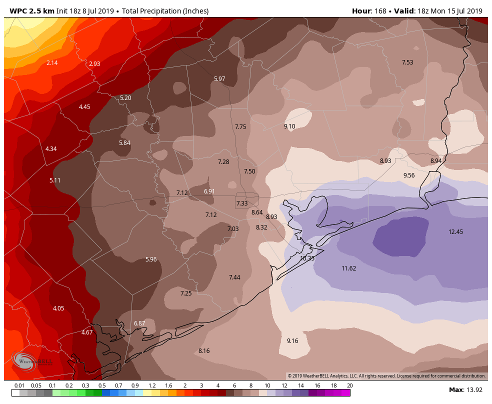
Thankfully, this storm should be moving steadily, so we do not believe it will linger down here for 5 days, though storm chances will remain in the forecast into next week. This rain forecast will be fine-tuned in the next few days, so expect some changes, but prepare as if we will be dealing with a heavy rain event in the area this weekend.

How strong will this storm get?
The reality is that we simply can’t answer that right now, but we can set some goal posts I think. Do I expect this to become a tropical depression? Yes. Do I expect a tropical storm? Yes. Do I expect a hurricane? No, but I would say your chances of potentially reaching category 1 intensity are better than 20 to 30 percent; still low, but clearly not inconsequential. This is my own opinion as a meteorologist and not an officially sanctioned forecast. Unless we see a pretty substantial farther south shift in the modeling for this system, I believe that’s the ceiling right now. It’s worth noting that solutions range from barely a depression on the GFS model to a solid Cat 1 hurricane (albeit keeping most serious impacts east of Houston) on the Euro. That being said, it doesn’t make sense to use explicit singular model solutions right now, which is why I am giving you a broader range of possibilities. It’s all we can do at this point.
Where will it go?
That’s the $1 billion question, right? Not entirely. Everyone looks for this answer, so here’s where we are right now. Like intensity, we don’t have the answer, but we have goalposts I think. I’m looking at a bunch of data, but one product I find useful at a very high level when explaining this is a “track density” plot from ensembles. Basically, this shows you what percentage of the 51 European ensemble model members has a system. This doesn’t tell you how strong or how wide-ranging the impacts will be; impacts will occur away from where the center of circulation tracks, so don’t focus on one singular point. But it helps to clarify the answer to the “track question.”
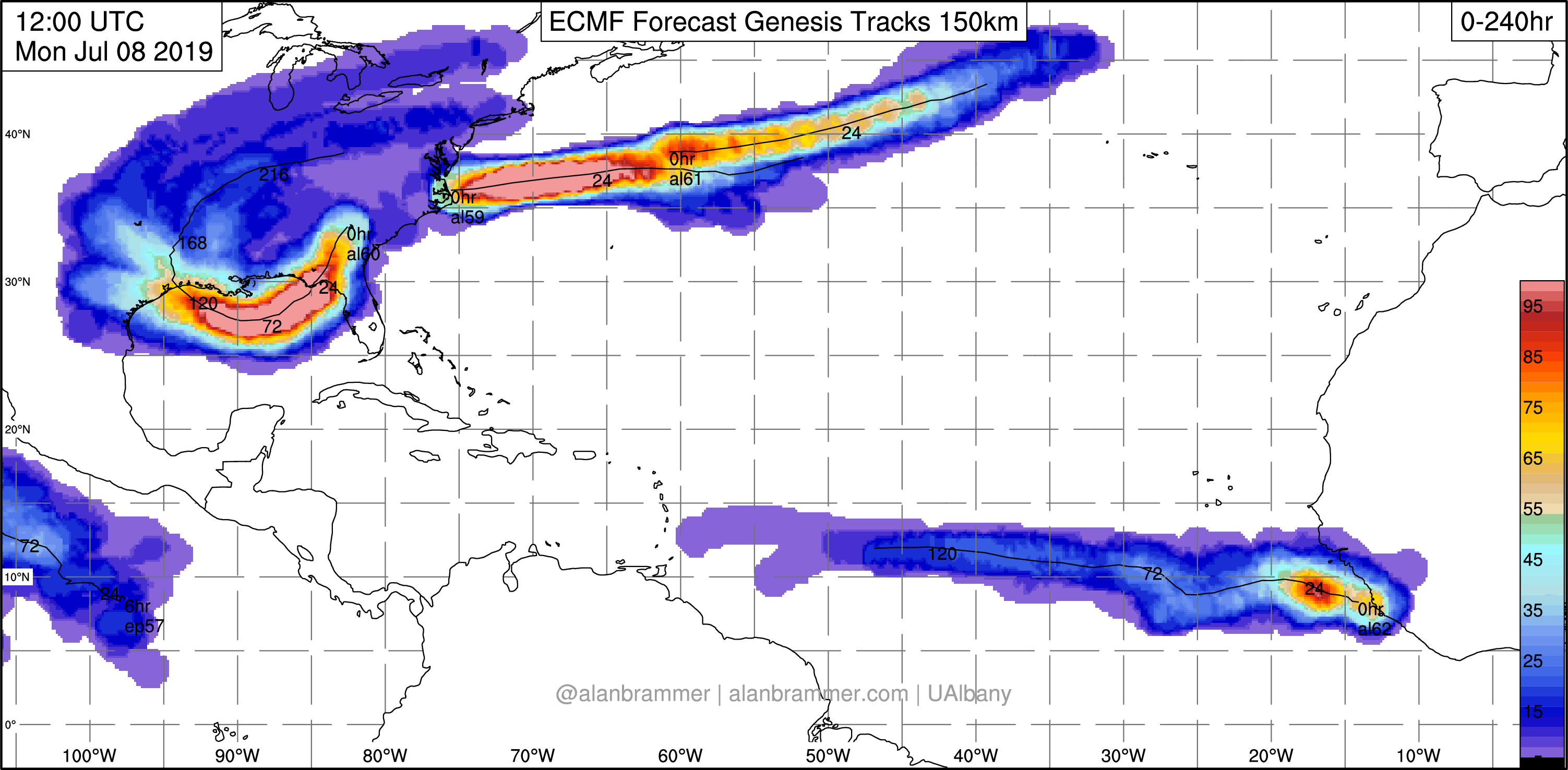
Using this, we can generally see that the system will track west off the Gulf Coast and eventually turn more to the northwest. Does that happen near eastern Louisiana or after it comes all the way west to the Coastal Bend. The takeaway for us is that the Houston area remains very much in play. This is a farther west shift relative to 24 hours ago, and I don’t want to rule out any coastal real estate for impacts at this time. The evolution of the disturbance and further model runs tonight and tomorrow will tell us a lot about where we can focus for landfall.
Here are some specific Twitter questions:
Equivalent storm tracks to the forecast range
— Jeff Henrichs (@heyjebbo) July 8, 2019
Is there any concern that this storm could blossom the way Harvey did once it gets into the gulf? I seem to remember most people saying the storm would be a weak hurricane at most, up until a day or so before it made landfall.
— Robert Green (@robertgreen500) July 8, 2019
As mentioned above, no, I don’t believe this to blossom like Harvey, but I struggle to ever proclaim something “isn’t possible.” Reality bites sometimes. But, the Harvey scenario happened over deeper, warm waters of the Gulf of Mexico. Harvey already had a distinct center of circulation coming off the Yucatan. Simply put, it had a head start over what this one will have. I think this one will also track just close enough to land much of the time to avoid that scenario. But history tells you a strong storm can happen.
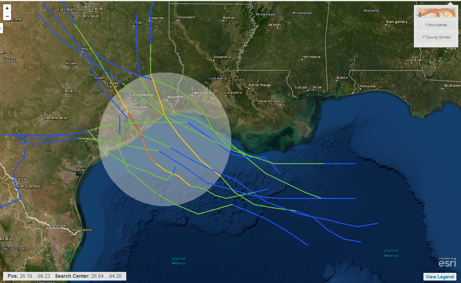
I went through our hurricane history back to the 1950s and I cherry picked storms that developed in the northern Gulf, south of Louisiana and moved generally due east to west and passed near Houston. I have about 10 decent analogs here. The only two that became hurricanes were Bonnie in 1986 in Jefferson County, TX (yellow line near Beaumont) and the big exception, Alicia in 1983 (red line). Alicia formed from a festering frontal boundary over the Gulf. Invest 92L or Barry will be via a complex of thunderstorms over the northern Gulf. The other eight were tropical storms. Not shown on the map is the 1943 “Surprise” Hurricane which came ashore as a category 2 storm near Bolivar. It’s tough to say that any of these are analogous one way or another to potential Barry. But this just shows you this isn’t as rare an event as you might think. So while a hurricane is not likely historically, it has happened in this manner before, so it remains wise to remain on guard.
What factors are influencing direction and intensity?
— Mumpsimus⚓️🇵🇹 (@WattsBack) July 8, 2019
What are the major factors that will influence where this system goes once it develops?
— Jared Colville (@jcolville12) July 8, 2019
There are a number of things to watch. First, the system hasn’t even formed a true center of circulation yet. That will be dependent on exactly how thunderstorms behave tonight and tomorrow in Georgia and Florida and how they maneuver offshore. So before we can get a decent answer on track, we have to watch things get going over the next 24 to 36 hours. Second, a trough and cold front dropping out of the Midwest and Plains could be enough to try and pull 92L north in time, perhaps keeping it closer to the coast and weaker, such as what the GFS model shows. It will still be a big ticket rain producer along the way, so don’t lose sight of that issue. Other factors include the strength and orientation of high pressure over the southern Rockies (which could steer 92L farther south toward the Coastal Bend) or how much wind shear will actually be present in the Gulf along the way. Change one of these variables or some others and your arithmetic can change considerably in terms of final outcome compared to where modeling shows things going today.
Give me some words of encouragement, please.
Absolutely! We live in Houston, and the reality is that tropical systems will impact us from time to time. In the last 15 years we’ve dealt with Ike and Harvey among some others. Ike and Harvey were unique, special storms. Not every storm will be like that, but it’s important to be prepared and knowledgeable about these things since we all live in a hurricane-prone place. The most important thing to do is make sure you have a stocked up hurricane kit, just in case. There is nothing in weather modeling right now to indicate that this will be a big ticket storm. But we always should be informed and prepared in the off-chance this does escalate. It is just simply part of life in our slice of the world. The more educated, aware, and prepared we are for the possibilities, the easier it is to deal with them. So hopefully you feel a little more informed now than you did a few hours ago. We’ll keep you informed throughout.
Just be glad we don’t live in California where earthquakes happen in an instant. Hurricanes and rain events are Houston (and SE Texas) bread and butter. Plan, execute and watch the forecast. Anything else is channel 11 level speculation.
Thanks guys! Really appreciate how you attempted to calm the masses with your logical explanations. For those of us who have grown up with these things, it helps to get some info on what-where-why-when. For those new to the area, it helps to get some information without all the hype and hoopla. So let me be the first…should Katy evacuate now or Thursday?
Wednesday at 10:18pm
Considering what happened to Katy during Hurricane Harvey, I truly hope this joke can finally be put to rest.
That was updated to 10:18:13.07
this is a great post, THANK YOU! and also LOL, on the encouragement of you live in Houston, storm will happen.
Thanks guys. Definitely an interesting setup. Can’t say I can recall a land based invest forming. What little I know. Thanks for Q&A and all of your knowledge.
Just a simple “THANK GOD FOR YOU GUYS!!!!”
I appreciate the plain speaking and lack of drama (apart from my abuse of exclamation points…) That’s is all:)
We moved away from Houston 2 years ago but I still follow your blog and appreciate your matter-of-fact, no-hype assessments. Sure wish we could find someone like you guys who would talk about the weather/wind/fire conditions in the Willamette Valley area of Oregon. I’ll be watching what happens in Houston this weekend and hoping for minimal issues in the Houston area.
Wonderful analysis. You guys rock!
Thanks guys for the update!
SPCWX FTW!
Much appreciation. I love spacecityweather.com!
Thank you for your explanations. We live in our RV on the coast in Galveston, is this something we should leave for? This our first time with tropical storms. Thank you!
We can’t really answer that for you unfortunately. You will want to heed the advice of local officials who are well-versed on those concerns and will know for sure what to do. Right now, just have a plan and keep following the forecast. But absolutely follow local officials too.
Heading to San Marcos thusday and returning Saturday. How will the traveling be returnig on Saturday coming back to the east side of Houston?
Well done with the Archer reference.
Eric and Matt, what happened to the Saharan dust? If it’s still in the gulf, will it keep this storm from turning into a big ticket storm?