Good morning. Let’s cover the next couple days, and then jump into the latest on the tropical system.
Today
It will be very hot once again today, with mid- to upper-90s likely across the region. Look for borderline heat advisory criteria once again, so be sure to take it easy if you must be outdoors. A stray downpour or slow moving storm is possible.
Thursday
Look for a more typical summertime afternoon tomorrow. We will likely hit the mid-90s before more numerous scattered storms pop up across the region. Some could produce heavy rainfall, though some parts of the area won’t see anything. Things should quiet down after sunset.
Friday, weekend, and future Barry
Let’s discuss the future of the Gulf disturbance, currently known as “Invest 92L,” or what should become Tropical Storm Barry tomorrow or Friday.
The one two sentence summary: Weather model data has shifted back a bit to the west with Barry, though the vast majority of output still keeps the center and worst impacts focused in Louisiana Friday through Sunday. Still, this would be close enough for at least some fringe impacts in Houston, and given that there is still some uncertainty, we cannot write off a further drift to the west, so be sure to check back in with us later today.
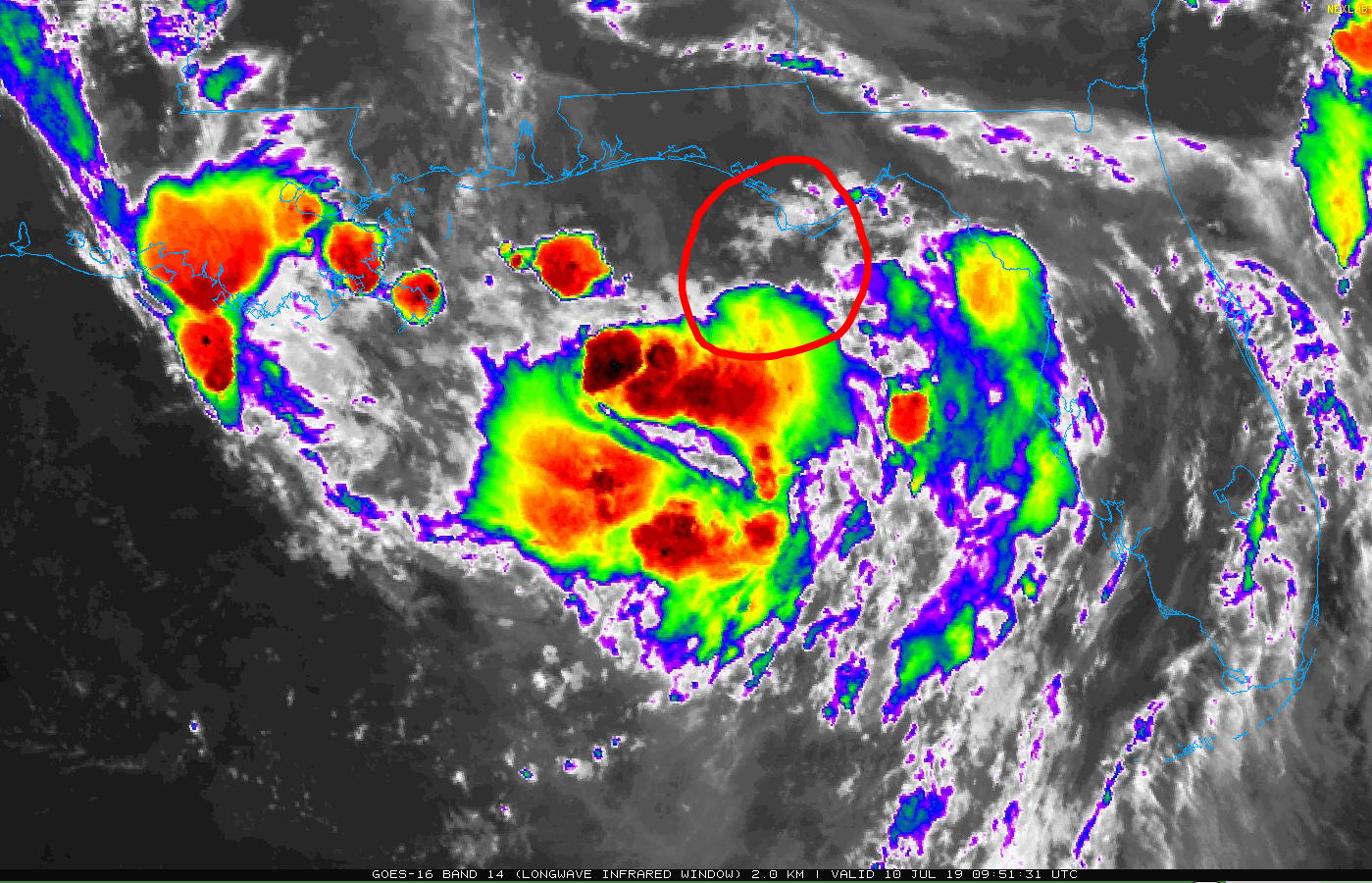
Now: The disturbance known as Invest 92L is over the Gulf, just south of Apalachicola, FL, or somewhere near the area I’ve circled in the satellite image below.
Over the course of today, 92L will likely slowly organize itself and drift to the south. Where exactly this occurs will have implications on both future track and intensity, so today is a critical day to watch observations and changes in modeling. It is possible, if not likely, that the National Hurricane Center will begin issuing advisories on this today or tonight, tagging it as a “potential tropical cyclone.”
Track: As of this morning, model data has shifted the track of 92L, as it develops into Tropical Storm Barry further west. Yesterday, model consensus pointed toward a track west and then a quicker lurch north into the Vermilion Bay area in Louisiana. This morning, that consensus has shifted about 50 to 75 miles further west toward Cameron, Louisiana. Here is a map of all the European ensemble tracks from the 51 ensemble members. What does this tell us? It’s basically the European model run 51 times with different initial conditions. This offers you a broader range of possibilities and includes some fringe ones you might not consider if you just use operational modeling.
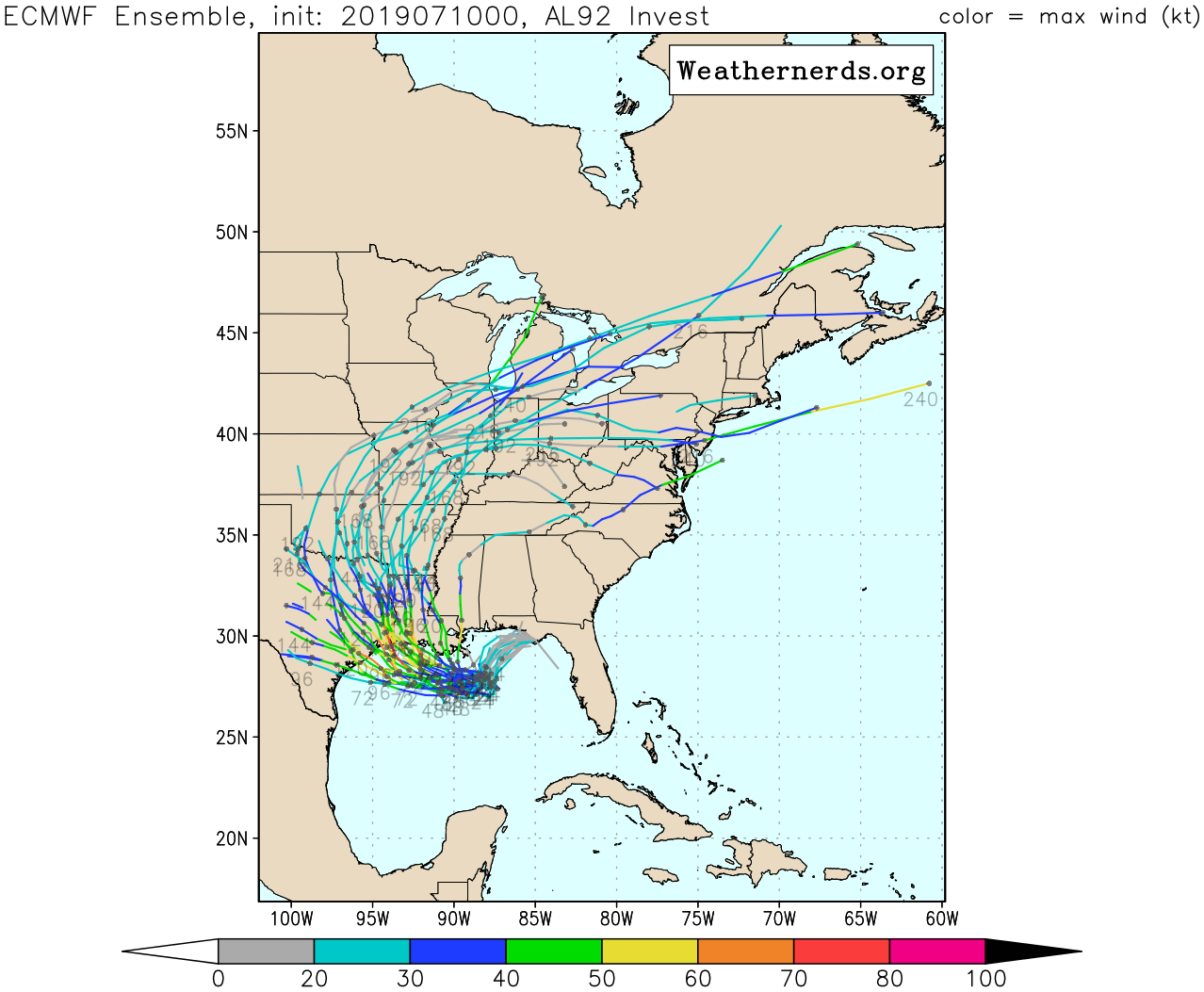
What we look for is trend and consensus. Yesterday, consensus was to the east of where it is today, so the trend is drifting back closer to us, meaning we need to remain aware of what this storm does. And there are still a handful of ensemble members that want to bring this even farther to the west and south. This is a very uncertain outlook at this time. Ultimately, the forecast track of future Barry is too close for comfort. Although we will hopefully gain more clarity on that later today, it will be important to make sure you have your plan and kit in place in case you need to act quickly beginning tomorrow. Hopefully this stays to our east and that’s that, but we cannot promise that and uncertainty remains annoyingly high, given recent trends.

Intensity: We will have a better idea on track before we do on intensity. As of now, the system is very disorganized and will only slowly get its act together today and tonight. How exactly that occurs will determine if this has a higher ceiling (hurricane) or a lower one (moderate tropical storm). The track will also partially influence this as well, given that the simple arithmetic is the more time spent over water, the higher the chance this has to become a hurricane. It would not be wise to speculate on exactly what intensity this will be when it comes ashore, but model consensus argues for a moderate tropical storm to a hurricane. Could it be a weak tropical storm? Yes. Could it be a Category 2 hurricane? While not a likely outcome, it’s still a possible one, so I don’t want to lie to you and tell you it couldn’t happen.
Again, while it’s frustrating to hear about this wide of a spread and high amount of uncertainty in track and intensity, it is literally the best we can offer at this time.
Timing: Direct impacts would likely begin to be felt beginning Friday afternoon or evening on the Louisiana coast or after midnight Friday night/Saturday on the upper Texas coast. Saturday would be the height of the storm, with improvement on Sunday.
Rainfall: The consensus outlook right now calls for the heaviest rain to be along and east of the track.The NWS is currently basing this outlook on a track between Cameron and Vermilion Bay in Louisiana. Thus, the heaviest rains are projected to be in central and eastern Louisiana.
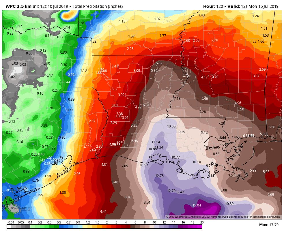
Total rainfall would be on the order of 5 to 15 inches in that corridor, with isolated pockets of higher amounts possible. If the storm track shifts farther to the west, that heavier rain will also come west. So much like track and intensity, there is considerable uncertainty on who will end up in the bullseye. With a fairly progressive, steady moving storm, that should keep rain totals from getting too far out of control, but anytime you’re talking a storm like this, flooding is possible (and if this does indeed happen in eastern Louisiana, it will be a big problem, given the very high river levels still in place there). So pay attention to how this changes in the coming days.
Best case for Houston: A track into central Louisiana, keeping almost all significant impacts east of the region, and leading to a mostly sunny, mostly dry, and very hot weekend.
Worst case for Houston: A track trend west that brings it into the upper Texas coast, leading to heavy rain, wind concerns, especially along the coast, and surge and tidal impacts. Details would be TBD.
Bottom line: There is still a high amount of uncertainty regarding 92L/Barry’s future. We still have a wide range of possible outcomes. Our hope is to get a little more clarity on things this afternoon, though it still will likely involve some amount of uncertainty. We likely won’t have some concrete answers until tomorrow. Eric or myself will update you again later today.
Reliant AC Giveaway
You have until 11:59 PM CT tonight to get your entry in for the first portion of Reliant’s air conditioning give away. The second round of entries will begin after that, lasting until August 13th. So if you haven’t entered and have an air conditioning system that is more than eight years old, check the rules and get your entry in. We will announce the winner probably after Barry is in the rear view mirror. Thank you again to Reliant for being our sponsor!
How strong do you think this will get? Will it move fast?
You should read the section he wrote on intensity.
Be nice. At least I didn’t ask about Katy.
Thank goodness! LOL
That WAS nice.
Assuming this continues a westward track and brings it into Houston or east Texas landfall, would you expect evacuation orders and when do you those would be issued?
Stated differently: what’s the odds evacuation for Galveston needs to come into play?
Sorry off topic — Matt, did you once write for Window Media? Houston Voice?
Is it too early to speculate on the the flood scale IF it centers on Houston? 5-15 inches (higher amounts possible) is a lot and we all know certain bayous and rivers can’t handle that much (not to mention Lake Conroe releasing and flooding everything downstream).
Flying out of Houston Hobby Saturday ~10:30 AM. Do you think in either best/worst case that the flight would be impacted?
Literally he wrote best case it will be a sunny day. Worst case it would be a bad storm. So… Worst case yes. Best case no. But even if the storm isn’t here in Houston it seems likely to impact at least some flights in and out of Houston to affected areas. You have at least some risk of a delay, regardless.
The GFS has it going into Louisiana, but the European model isn’t so sure, with some tracks as far south as Corpus. Today’s National Weather service rainfall estimates for the Houston area are much lower than their estimates from yesterday; are they trusting the GFS more than the Euro model?
https://www.weathernerds.org/tc_guidance/storm.html?tcid=AL92
How do we know where it’s going if we don’t know where it begins? Until a center forms, this all seems pointless to speculate.
actually i think I do see a center south of panama city, much much further south than most of these models said. Not sure that would change the path but might change the intensity.
If it is further south than the models predicted that could mean a more west landfall
Yep I see it, it’s definitely further south. They’re sending a recon aircraft so we’ll find out soon enough.
I have reservations for a beach house in Crystal Beach Friday – Thursday. I’m still planning on going. I’ve got plenty of “beverages” and pictionary!!
Matt, I live at 123 main st. I’m traveling to 456 2nd st. At what exact time will it rain and exactly how much? Can you please give me much more specific info. I’m an adult incapable of discerning information and applying it to myself.
Also, I’m in Katy. Will evacuations be necessary?
…and so it begins.
If you can’t detect sarcasm, then you should have your ability to be offended to be taken away.
Katy got flooded pretty badly during Harvey, so this joke is rather old and obsolete. Lots of people needed rescue from their homes there.
I know they did. I work there and used my boat and kayaks to assist many people. I opened my shop to help first responders repair tires etc. Relax. Katy proper wasn’t too bad. I’m sure plenty of people have a Katy address and had a bad time. Energy corridor and downstream from Addicks was pretty rough west of I-45…. other communities were worse than that.
It’s a long played out joke on this site. Learn to laugh. Many people ask the hard working Matt and Eric for oddly specific weather reports. They do this for basically free. The commenters deserve ridicule, and the Katy meme has history.
Some community had a bad time once upon a time. We should never make any joke referencing them again for all eternity. Lighten up Francis
I hate this time of year.
My sister-in-law is getting married in New Orleans Saturday night. We are planning on driving up on Friday. Is that a bad idea?
Keep an eye on it, but parts of the city are already flooding this morning
https://www.chron.com/news/texas/article/New-Orleans-states-along-Gulf-brace-for-14084730.php
Does my daughter at LSU (Baton Rouge) stay or quickly drive home to Clear Lake?
should katy evacuate?
Houston area still in the “cone of uncertainty” (not related to the cone of silence from Get Smart):
https://www.nhc.noaa.gov/refresh/graphics_at2+shtml/173249.shtml?gm_track#contents