The forecast is a mess. If you’re looking for light and sunshine, you’ve come to the wrong place.
As of 8am CT the radar over Houston is clear, but that is likely to change later today. A combination of daytime heating, an upper-level disturbance and a northward moving boundary between warmer and colder air should again create another rocking and rolling afternoon and evening.
TODAY
A boundary stretching from north of Corpus Christi to south of San Antonio is lifting north this morning, and should provide a focus for storms across parts of the Houston metro afternoon later this afternoon and evening.
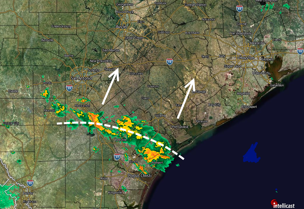
At this point it appears slow-moving storms may move into the Houston region by around noon, or shortly thereafter. It’s not possible to say where the most intense rains will fall, but this moist air mass is capable of producing locally heavy amounts. Yesterday, for example, areas near both Hobby Airport and Westbury received in excess of 5 inches of rain, whereas Baytown received almost no rain whatsoever. So some areas may see a lot of rain today, whereas others will get a chance to dry out. Intense thunderstorms and hail are possible again.
It seems likely that storms will weaken with the loss of daytime heating, after 8 or 9pm CT.
MONDAY
But the fun doesn’t stop there. The air mass remains very moist on Monday, and a pretty powerful upper level storm system looks set to move through, bringing a chance of heavy rain to the region. It’s not clear whether the strongest rains will come during the morning hours, or Monday afternoon. But there is the potential for the region to pick up another 1 to 4 inches of rain with this system. Isolated totals will probably be higher than this.
TUESDAY
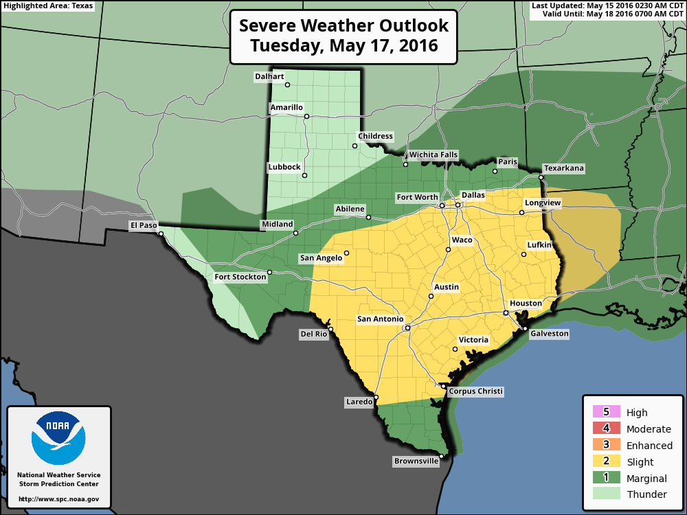
After hopefully a break following Monday’s storms, an approaching front will bring the potential for some more severe weather later on Tuesday, perhaps around sunset or thereafter (at this point the timing for these events is kind of a crapshoot). The chance of severe weather (thunderstorms, hail, damaging winds) is probably greater for inland areas than along the coast, but the entire Houston metro area is under a “slight” risk for severe weather from NOAA’s Storm Prediction Center.
WEDNESDAY through FRIDAY
More rain likely. The active storm pattern over Texas is unlikely to change much for the second half of the work week, which means we’ll have to continue to watch for the potential of heavy rains and severe weather through Friday at least. But there’s so much uncertainty about the timing of these storms during the latter half of the week it’s not worth saying much more at this point. Suffice it to say, the risk is there.
Posted at 8:30am CT on Sunday by Eric Berger
So, not BBQ weather then?
Unlikely.
Thanks for keeping us up-to-date, Eric.
Eric, is this round of rain an X-year event? Because it seems to me like normal Gulf Coast weather. Last night Meyerland came perilously close to house flooding. Another few days of that and houses will flood again.
All the more reason people in Houston need to start packing up their cars and leaving the area right now!
Seems like typical Houston weather – sorry the CoH let the developers go crazy with the impervious ground cover.
Drive North Eldridge now, water level is less than a foot from the road in the low spots. If it rains they will close the gates and the road will go under again.
What do you mean, by “inland areas,” Eric? Spots north of Houston?
I-10 and points north.
“pretty powerful” you said. As powerful as the April 18 rainmaker, Eric?