Most of the Houston area has remained shower-free this morning, but we’re becoming concerned about a boundary between warmer (to the south) and cooler air masses that has set up a bit to the north of Interstate 10 today. Its position at 11:45am CT is shown below.
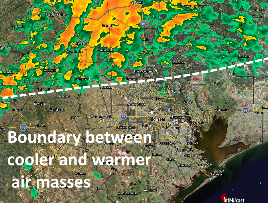
We’ve seen storms form north of this boundary today, including over already hard-hit areas of southwestern Montgomery County, and this should continue. That’s because there’s an ample flow of moisture and warmth coming from the south-southwest which is helping to feed storm development. As the day progresses we could see this boundary sag further south, bringing some heavier storms into the central Houston metropolitan area.
There is a lot of uncertainty in the forecast, but even a few more inches of rain across northern Harris, southern Montgomery, Waller and Grimes county would prove very troubling. And the prospect of heavier rains moving southward into the central Harris County area later this afternoon to start off the Memorial Day weekend isn’t particularly appealing either. We’ll be keeping a close eye on developments for you.
Posted by Eric Berger at 11:55am CT on Friday
thank you, Eric.
Hard rain just beginning again on the Austin/Colorado County line, near Industry.
Thanks for taking the time to update during the day.
Seeing a pattern of “surprising” developments over the last few weeks (both surprisingly wet or suprisingly dry)…. What gives? What is it about that conditions that is making our usually very trusted weather source … less so.
It’s always hard to pin down the details of severe rain events along the Gulf Coast of Texas. With that said, we have been talking about heavy rains on Thursday and Friday for a couple of days, especially to the north-northwest of Houston.
Thanks for keeping us up-to-date, Eric.
Eric, headed to IAH for an overseas business trip leaving about 4pm…not looking good for leaving on time??
May be some delays, but hopefully nothing too severe. I’d be more worried about the TSA lines!
So, what’s causing this? When I look at radar, the storms appear to be generating out of thin air. Almost has an assembly line look to it. Haven’t seen this in awhile (but I’m not a weather guy).
We’ll have an explainer in the next day or two, but first we need to get through this. Short answer is a LOT of moisture and lift.
And when does this end?
Should be around sunset-ish.
What about driving Houston to Dallas?
A mess right now, but fine once you get past Conroe.
Looks like I’m not going to College Station this afternoon…