November’s site sponsor: Innovo IT Solutions

A new month means a new sponsor for Space City Weather, and I’m pleased to announce that Innovo IT Solutions has returned to support the site in November.

Innovo IT Solutions
Innovo IT Solutions

Thanks to their generous support we can provide all of our weather content for free, and without advertisement, for the entire month of November. Here’s a little bit more about their business:

Innovo IT Solutions, LLC is a rapidly growing consulting firm providing professional technology services and Microsoft technology solutions. One of our main strategic objectives has always been to work closely with our customers and become a trusted advisor and a premiere supplier of highly specialized solutions and resources. We work collaboratively with our clients, enables them to leverage technological innovation and achieve maximum results by successful use of people and technology. Innovo’s engagement model includes offshore, off-site and on-site. To meet our client’s needs we have setup a dedicated offshore teams in Philippines and India and have a local technical manager to manage our relationship with our clients.

The advantage of the sponsorship model is that we are under no pressure to generate web traffic for the sake of web traffic—so there’s no hype, no click bait and no nonsense. All we’ll do is continue to make the best possible forecasts we can make. Thank you for considering them for all your IT needs. By doing so, you’ll be supporting this site!
Scattered storms today and Thursday in Houston, spectacular weekend ahead

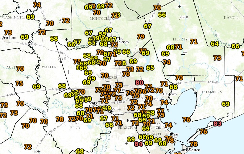
It’s a very warm morning for early November across the Houston area, with low temperatures ranging from 68 degrees north of Houston all the way up to 76 degrees down in Galveston, which likely will tie a record for a warm low temperature. We’ll continue to see these kinds of conditions, along with scattered storms, for a couple of more days before this warmth finally breaks.

Temperatures as of 6:20am CT. (National Weather Service)

Today and Thursday

The pattern remains more or less the same. With moisture streaming in off the Gulf of Mexico, expect to see more cloudy days, with scattered rain showers. Some areas of Houston, especially west of the city, saw brief, heavy storms on Tuesday, and that pattern should continue for the next couple of days. Meanwhile, high temperatures will reach about 80 degrees where there are heavy clouds, and could climb all the way into the mid-80s for areas that see a bit of sunshine. Overnight lows will remain anomalously warm.

Friday

A cool front will push into Houston late on Thursday or early Friday, but the cooler and drier air will lag somewhat. As I noted yesterday, we’re going to have to wait until Friday evening to really see dewpoints begin to fall and the air to dry out. So expect one more day with highs of around 80 degrees. Rain chances will be near zero.

See full post

How the jet stream is keeping Houston hot and dry

October ended as an usually hot and dry month. Eric covered this a bit yesterday, but weather data from Houston’s Bush Intercontinental Airport shows that 25 out of 31 days were warmer than average, with a measly 0.14 inches of rain recorded for the month. By the end of October, the heat and lack of rainfall produced drought conditions in the eastern third of Texas.

The jet stream

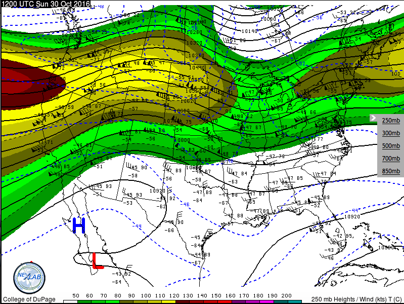
Figuring out why our weather has been so warm starts with analyzing the jet stream. The image below is an upper-air map, showing the state of the atmosphere at 250mb (about 30,000 feet above the ground, or a just above the peak of Mount Everest).

250 mb map showing the location of the jet stream on 30 October, 2016 (courtesy of The College of Dupage)

See full post

Just three more days before the end of Houston’s very warm streak

Houston’s high temperature peaked at 85 degrees on Halloween, but our run of very warm (for late fall) weather will soon come to an end—by this weekend. And after this week I think we can look for most days to only reach the 70s as we get deeper into November.

Today through Thursday

But the warm, muggy air is not ready to go yet. With air now flowing off the Gulf of Mexico and into the Houston area today, expect the next few days to see mostly cloudy skies, with highs in the low- to mid-80s, and some scattered showers. Rain chances will be greatest today the southwest of Houston, closer to Matagorda Bay, where moisture levels should be highest. More widespread rain is possible on Thursday across the Houston area as some instability moves in along with an approaching front. But I don’t think we’re going to see significant accumulations of more than a tenth of an inch of rain, or two. Nights won’t see much cool down through Thursday, with temperatures only falling to around 70 degrees for most areas.

Friday

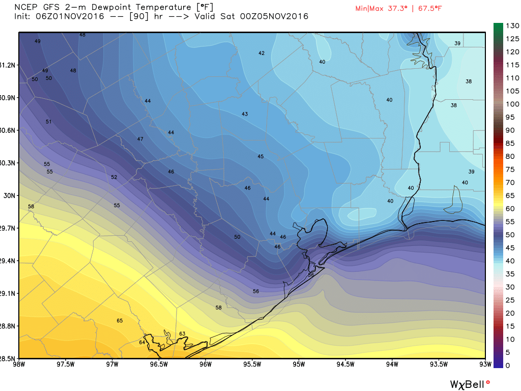
After a cool front limps into Houston later on Thursday, the region should being seeing some drier air on Friday, which will set us up for a pretty nice weekend. Under mostly sunny skies we should see a high of around 80 degrees, with a low of 60.

Although a cool front should arrive late Thursday, much drier air is unlikely to move in before Friday afternoon. (Weather Bell)
Although a cool front should arrive late Thursday, much drier air (noted by dewpoints) is unlikely to move in before Friday afternoon. (Weather Bell)

See full post