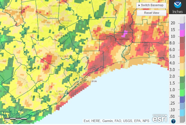
The end of what has been a wet week is near. The Houston region has generally received from 2 to 8 inches of rain during the last seven days. Although the rains did cause some isolated flooding and cancel some outdoor events, by and large they were beneficial—quelling what had been an emerging drought just as we’re entering the warmest months of the year. Here’s a look at accumulations during the last seven days.
Seven-day rainfall accumulations. (NOAA)
Today
The radar is largely clear this morning, and skies are partly to mostly sunny across the region. While atmospheric moisture levels have come down, they’re still high enough that we should see some scattered showers and thunderstorms develop later today into this evening. Accumulations should be slight, except possibly for a few isolated locations. Highs in the upper 80s.
Welcome to the beginning of the 2017 Atlantic hurricane season! This year I’m thrilled to announce that Space City Weather has teamed up with an Extreme Weather Partner, Reliant, for the entire six-month season. And that’s a good thing, because although we don’t put too much stock into seasonal forecasts, there are some reasons to believe this season may be fairly active across the Atlantic Ocean, Gulf of Mexico, and Caribbean Sea.
As part of our agreement, Matt and I will be writing a handful of posts during the next six months about extreme weather, and some of the options residents have to prepare for hurricanes, power outages, and other weather-related problems that can arise in Houston. Beginning with this one, these will clearly be marked as sponsored posts, but will be written by us, for you.
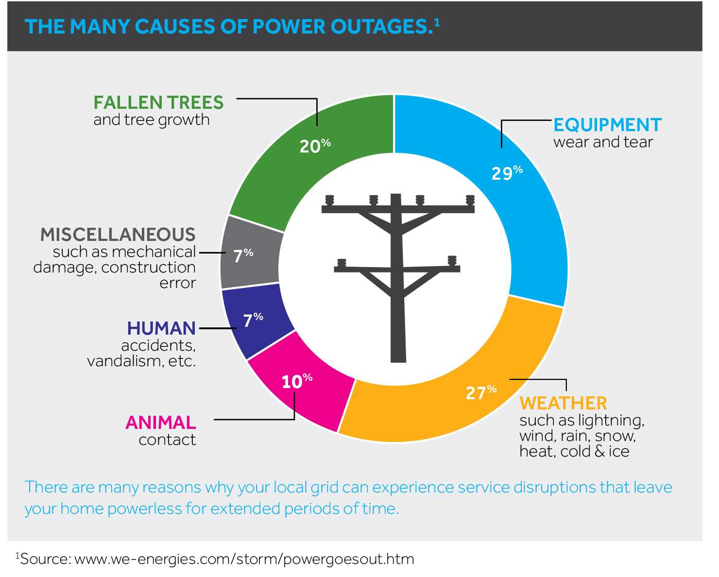
Outages
To kick off hurricane season, we’re going to delve into the topic of power outages and generators. Aside from life-threatening hazards and damage to one’s home or business, outages are among the most significant inconveniences during inclement weather. Anyone who lived in Houston during the aftermath of Hurricane Ike will know this well. Outages can be dangerous, too, as people sometimes attempt to operate gasoline-powered generators indoors, or take other extreme measures.
(We Energies)
When the power goes out, thanks to the Internet, it is now easy to report the outage and get an update on when service is most likely to be restored. For most of Houston, the “poles and wires” infrastructure that delivers power to customers is CenterPoint Energy. They are the conduit for power provided by retail electricity providers like Reliant.
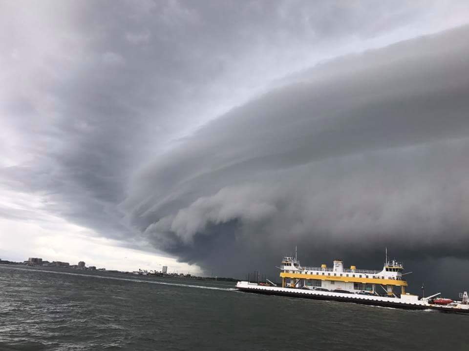
Sunday produced widespread, heavy rain across the Houston area, with generally 1 to 5 inches. Accumulations were greatest near Galveston, and just to the southeast of the Houston area. Some of the storms were quite ominous, such as the clouds depicted in this photo from the Galveston-Port Bolivar Ferry System. Others, such as a large system that moved through downtown during the afternoon hours, produced a lot of lightning.
Boats in the Galveston-Port Bolivar Ferry system sheltered briefly during Sunday’s storms. (Twitter)
The conditions that produced these storms, particularly a moist atmosphere and slow-moving upper-level low pressure system will remain in place today, so we can expect another wet day before we begin transitioning to drier weather later in the week.
Today
As the upper-level system slowly moves from west to east across the region, we’ll see another wet day—especially later this morning and into the afternoon hours as daytime temperatures move into the mid- to upper-80s. Some regions could see another 1 to 3 inches, with greater localized amounts, especially to the east-southeast of Houston, from Galveston to Baytown. Given the already wet soils, we’ll have to be more concerned about the potential for flash flooding today. We’ll keep an eye on things.
The National Weather Service has issued a flood advisory for much of the western half of the Houston area this afternoon. The warning comes as a large area of thunderstorms moves into the region from central Texas, and is in effect until 4:30pm CT. I’m especially concerned about the potential for lots of lightning.
Area of flood advisory through 4:30pm CT. (National Weather ServicF
The region’s moist atmosphere has already produced heavy rains and some flooding overnight near College Station, and this morning along the coast with some areas getting as much as 6 inches.
Would expect minor flooding from the system moving through on Sunday afternoon—rather than major flooding—but if you’re planning to be out and about this afternoon and evening in the Houston area, please take an umbrella and check the radar. Some parts of Houston may see 2 to 4 inches from these storms today and this evening.
Rain chances will remain on Monday and Tuesday before a cool front (yes, really) dries us out for the second half of the work week.