A decent chance for rain today as a “front” moves through Houston

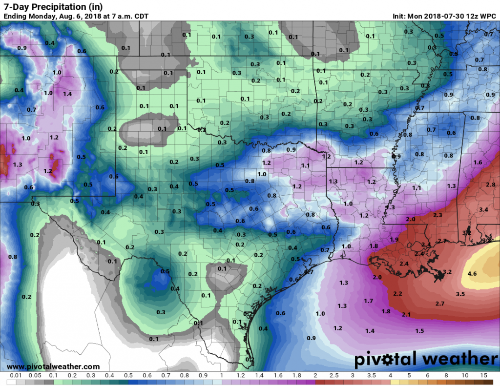
Parts of southern Houston saw some thunderstorms on Monday afternoon, and as a “cold” front slogs through the area we’ll see another healthy chance of showers later today. After the heat of this month, with an average temperature likely ending up as about the 10th warmest July on record, today’s slightly cooler weather will be a nice way to transition into August.

Tuesday

The front is still north of Houston this morning, but should gradually push through the city and to the coast throughout the day. The best chance for showers—and I’m sorry, but not everyone is likely to see rain today—will probably come between noon and 6pm today. Accumulations for those who do get rain will probably measure in the 0.25 to 0.75 inches, with higher isolated totals within thunderstorms. Depending on the extent of rain today, highs will probably range from about 90 to 95 degrees. After the front moves offshore, rain chances should end this evening.

Probability of a given area getting at least one quarter of an inch of rain on Tuesday. (Pivotal Weather)

Just a few words about the front. This is a cold front, but as we’re in the dead of summer, it is not going to bring any colder air into Houston. We will see some drier conditions, which could make mornings for the next day or two a little bit more pleasant, especially for inland areas. But the region is going to remain hot.

See full post

Rain chances finally return to Houston’s forecast

Houston’s high temperature has reached 100 degrees four times during the last eight days, which almost meets our “normal” quota for the total number of these days during a calendar year. Now, fortunately, we’ll take a slight step back this week with the heat, and also return some welcome rain chances to the forecast. Not everyone will get rain this week (sorry), but I expect most of the region to pick up between 0.25 and 0.75 inch of rain between now and next time this week. This should also help with African dust levels, as discussed below.

Rain chances this week are better for East Texas than the Houston region. (Pivotal Weather)

Monday

This will be another warm day for Houston, with high temperatures in the upper 90s, and clear skies this morning. However, some clouds should work their way into our skies this afternoon, and the eastern side of the city will see some moderate rain chances—perhaps 20 to 30 percent as some storms moved into the region from Louisiana. At the same time, a weak cold front will be moving down the north of the state, and this will bring some additional instability into the area, and portend better rain chances on Tuesday.

Tuesday

For the first time in what seems like weeks, skies should be mostly cloudy rather than mostly sunny. This, alone, should help keep high temperatures in the low 90s. Conditions aren’t perfect for rainfall, but the stalling front combined with surface moisture should be enough to generate some showers and thunderstorms for parts of the region. Again, accumulations won’t be too significant, but after a dry spell during the second half of July anything will be welcome.

See full post

Houston officially reaches the dog days of summer

Congratulations, everyone. We’ve reached the dog days of summer—the period of warmest temperatures during the year. Based upon temperatures from 1981 to 2010 at Bush Intercontinental Airport, the normal high temperature for July 27 kicks up to 95 degrees, from 94 degrees on July 26. The region’s normal high will remain 95, and the low 75, from now until August 21, when the high temperature drops back down to 94 degrees. Thus, while the temperature differential is admittedly slight, the next three-and-a-half weeks are in fact the historically warmest part of the year for Houston. The good news is that, in less than a month, we’ll begin (ever so slowly) sliding toward fall.

Friday

Hot and sunny conditions will persist today, with highs ticking up to near 100 degrees across most of the region except for the coast.

The heat will spread across Texas today. (Pivotal Weather)

Saturday

Some moisture will begin to work toward the area, and we could see some showers far to the southwest of Houston, such as Palacios, or to the east, such as Beaumont. Houston itself should remain dry, however, with mostly sunny skies and highs in the upper 90s.

Sunday

Slight rain chances will return to the forecast, as moisture levels begin to creep back up in Houston itself. The models are split at this point, but we can’t entirely rule out some scattered rain showers in the city. For the most part, however, expect sunny skies and highs in the upper 90s.

See full post

Yes, Houston, some relief from this heat really is on the way

Houston will enjoy one more morning with slightly cooler and drier weather—a few areas north of Houston, such as Conroe, will again briefly dip into the upper 60s—but overnight weather will gradually warm up over the next few days, and high temperatures will remain hot through the weekend. However, we remain confident in a reversion to somewhat cooler and wetter weather for the end of July and August.

Thursday

With high pressure in place, we can expect very hot weather, with highs near 100 degrees, sunny skies, and only the slightest gasp of a wind.

A full-on summer day for Houston on Thursday. (Pivotal Weather)

Friday, Saturday, and Sunday

The weekend may bring a few more clouds, which could act to hold temperatures back a few degrees. Still, I’d anticipate highs in the mid- to upper-90s with mostly sunny skies.

See full post