Houston ties record for warm morning, but a super weekend ahead

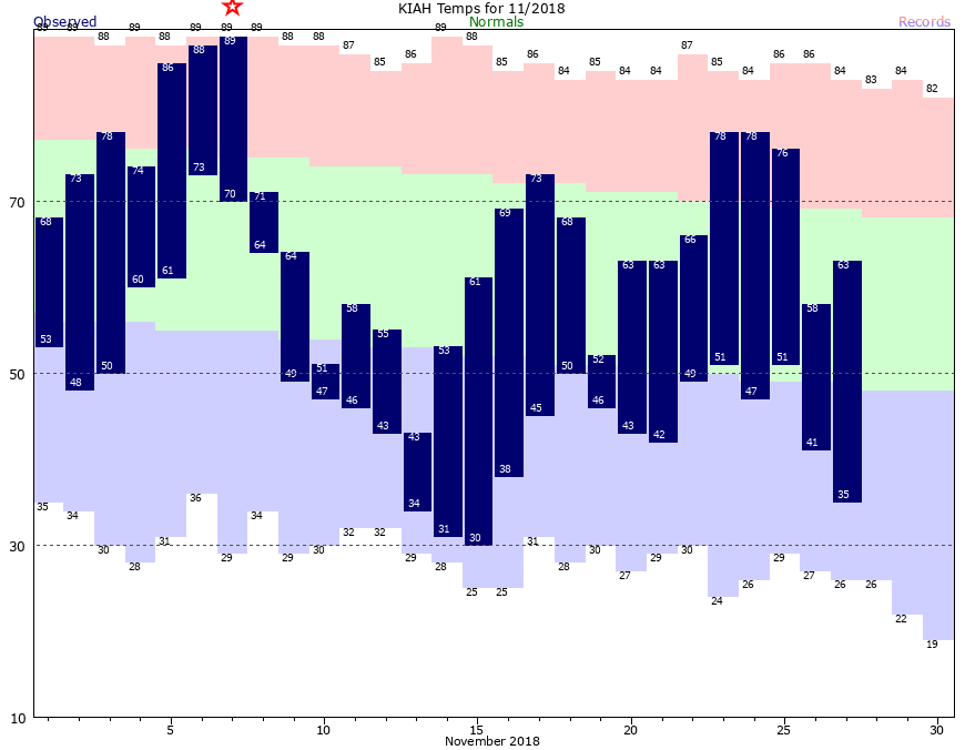
It’s quite warm out there for late November, with lows in the upper 60s. This is nearly 20 degrees warmer than normal for this time of year, and right now the “minimum” temperature of 69 degrees at Bush Intercontinental Airport this morning ties the record for “high minimum” temperature on Nov. 30 in Houston. A weak front, and then a stronger front, will soon bring an end to these warmer conditions, however.

Friday

Friday will be a lot like Thursday, which is to say mostly cloudy, with muggy conditions, and highs likely in the upper 70s. The region will also likely see some scattered showers today and this evening, but these should be nothing too serious. It will be another warm night, but a cool front should move through during the overnight hours, bringing some drier air with it. Can’t rule out some showers with the frontal passage, but at most I expect a broken line of storms to move through the area.

Any rain accumulation Friday and Friday night should be moderate. (National Weather Service)

Saturday

A really nice day. In the wake of Friday night’s front, drier air will flow in from the west, and this will push humidity levels down during the daytime. Highs will generally be in the upper 70s, but some areas may briefly touch 80 degrees under mostly sunny afternoon skies. Temperatures will fall fairly quickly as the sun sinks toward the horizon, and overnight lows will be in the 50s for most of Houston, except the coast, which should be a little warmer.

See full post

Terrific weather alert: Saturday may be one of the five nicest days this year

The onshore flow has taken over the region’s weather, and we’re now set up for a pair of gray, on-and-off rainy days with muggy air. The clouds should keep highs in the 70s, but conversely nighttime temperatures aren’t falling much below 70 for most of Houston. A weak front arrives early Saturday, and a stronger one later on Sunday or Monday to bring us back into a late-fall, or early-winter like pattern of cooler weather.

Thursday and Friday

The name of the game for the next two days will be gray skies with scattered showers. Lows this morning are generally in the low- to mid-60s, and with dewpoints at just about the same level, relative humidity is near 100 percent.

Severe weather potential for Friday, Nov. 29. (NOAA)

Rainfall on Thursday will generally be light, while there is the slight possibility of some thunderstorms on Friday. This is because a fairly strong storm system will be moving across the lower plains, and bringing severe weather, including the potential for damaging winds and a few tornadoes. However, the region where the atmosphere is more disturbed should remain north of Houston, running from Lufkin through Texarkana and into surrounding areas shown in the map above.

See full post

A chilly November will end on a warm note for Houston

This November has provided some significantly cooler weather than we’re accustomed to, with an average monthly temperature nearly 5 degrees below normal. (A warm start will keep this month out of the top-10 coldest Novembers). However, we’ll now end the month with a string of warmer days and nights that will last into early December before a stronger cold front arrives next week.

Houston went from a record high of 89 degrees on November 7 to a freeze a week later. (National Weather Service)

Wednesday

A few outlying areas are seeing lows in the upper 30s this morning, but for the most part the city has remained in the 40s or (near the coast) 50s. Winds have already shifted to come from the south, and this will bring us a steady stream of warmer, and more humid air. Highs today will reach into the low 70s, although as clouds build later this afternoon I wouldn’t expect highs to go above that. Lows tonight are unlikely to fall below 60 for most of the area.

See full post

Houston to warm up, with another nice weekend likely on tap

Conditions are quite cold across the region this morning—with near freezing temperatures in most of Houston, and a light freeze over northern areas such as Conroe and Huntsville—as we grapple with our latest strong front. The good news is that we’ll see a warming trend this week, and as of now, the weekend looks pretty nice.

Before jumping into the forecast, I just want to say a truly heartfelt thank you to all of our readers who have contributed to this year’s fundraiser for Space City Weather. We’ve had a tremendous response so far—inspiring, really. With less than 24 hours remaining, we’re on pace to top last year. Again, buying a t-shirt or umbrella, or donating, is entirely optional. We’re committed to keeping the site free, regardless. But we really do appreciate the help.

Tuesday

With high pressure dominating our weather, we’ll see mostly sunny skies today, and we should see a warm-up into the low 60s. Temperatures will be warmer tonight, as the onshore flow kicks in. I’d expect lows to be about 10 degrees above lows on Tuesday morning, so we’re done with the freezing temperatures for now.

Low temperatures on Wednesday morning won’t be quite so chilly. (National Weather Service)

Wednesday

This will be something of a transition day, as atmospheric moisture begins to flow back into the region. I’d expect partly sunny skies, with a high in the low 70s, and returning humidity. By Wednesday night clouds should be back in force, and this will keep most of the city at around 60 degrees for lows.

See full post