A nice, slightly warmer weekend ahead, so when is Houston’s next front?

After a truly delightful stretch of autumn weather the last week or so, the weather pattern will change this weekend, ushering in slightly warmer temperatures (especially in the mornings) and noticeably higher humidity. Overall, it should still be pretty nice though!

Today

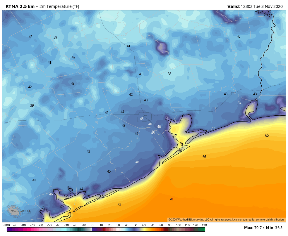
Look for abundant sunshine today. We’ll manage to warm into the low-80s this afternoon after a cool start in the 50s for most.

Weekend

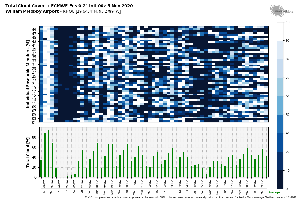
We should continue with partly to mostly sunny skies this weekend, although I think we’ll probably see at least a few more clouds on Sunday. Shower chances should be very low and mainly off to our east. They won’t be zero though, so don’t be shocked to see some sprinkles or a passing shower, especially east of I-45 on Sunday.

Sunday morning should feature low temperatures back up into the 60s in most places as humidity returns. (NWS forecast via WeatherBell)

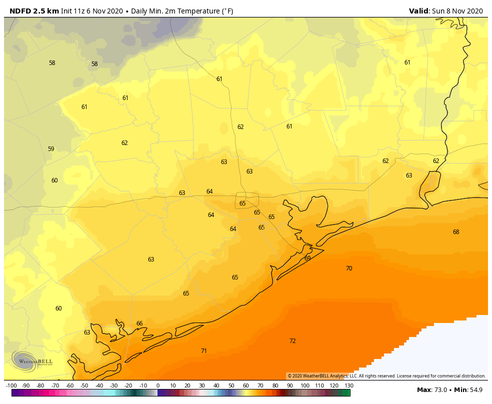
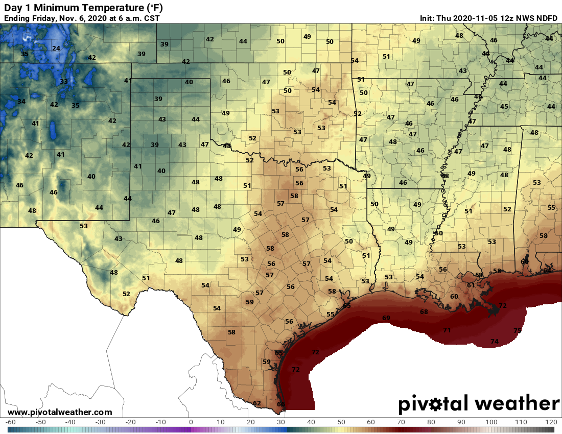
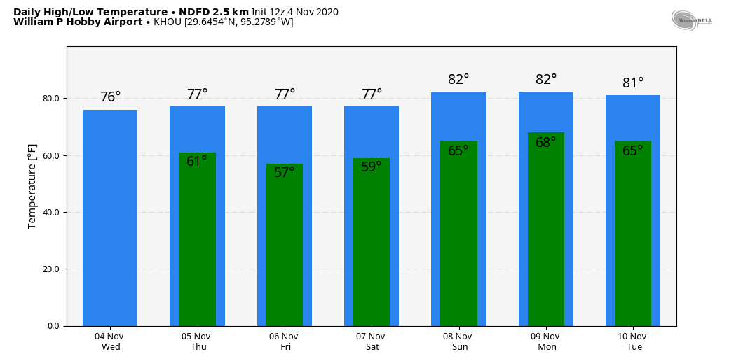
While daytime highs should be basically in the low-80s each day, morning lows will build from the upper-50s tomorrow, about 5 or 6 degrees warmer than today, to the mid-60s on Sunday morning.

Next week

We will continue to see temperatures and humidity build a bit on Monday. There should be a good amount of morning low clouds around, followed by some gradual clearing. That said, an isolated shower is possible. Highs should again be in the 80s after starting the day in the mid- to upper-60s. Tuesday sees a cold front approach the College Station area. We will again be warm with highs in the 80s and lows in the 60s, if not low-70s.

The question then becomes: Does that front get to Houston? Right now, the answer is probably not. At least not right away. Expect that front to flirt with us or areas to our west into later next week before perhaps getting a kick through by next weekend. We should see a mix of sun and clouds in the lead up to that. Temperatures will still be warm, but they might be a few degrees cooler than early in the week, however. More on this for you Monday.

We could use some rain

Since Tropical Storm Beta back in late September, the Houston area (officially) has had less than 1 inch of rainfall. Some places have seen some more, others less. While Harris County is not in drought, we are starting to see pockets of drought flare up in surrounding counties.

Drought is slowly expanding in the counties surrounding Houston. (UNL Drought Monitor)

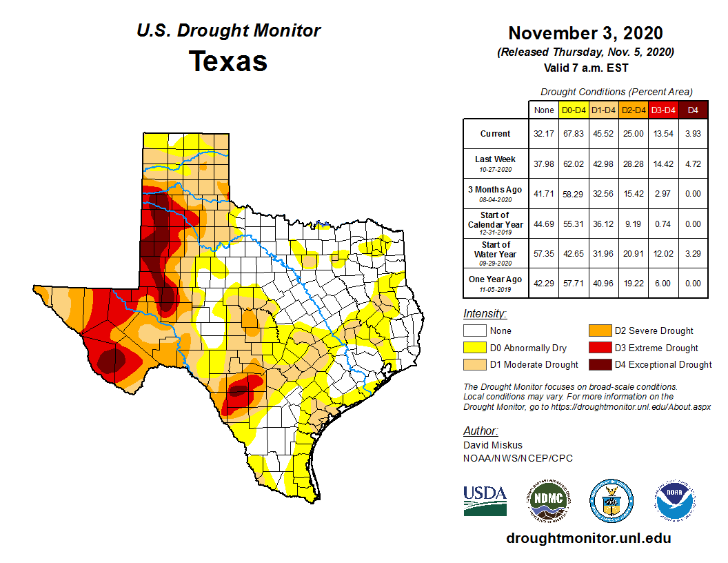
We could use a bit of rainfall. While the chance of showers isn’t zero over the next week, we aren’t expecting any meaningful rain. Perhaps with next weekend’s cold front push. We’ll see.

Tropics

Tropical Depression Eta is expected to return to tropical storm strength this afternoon or tonight. It will then take a very convoluted track over Cuba, possibly east of Florida, then back west into the Gulf.

Eta is expected to become a tropical storm again before taking a really abnormal track around Cuba and Florida over the next 5 to 7 days. (NOAA NHC)

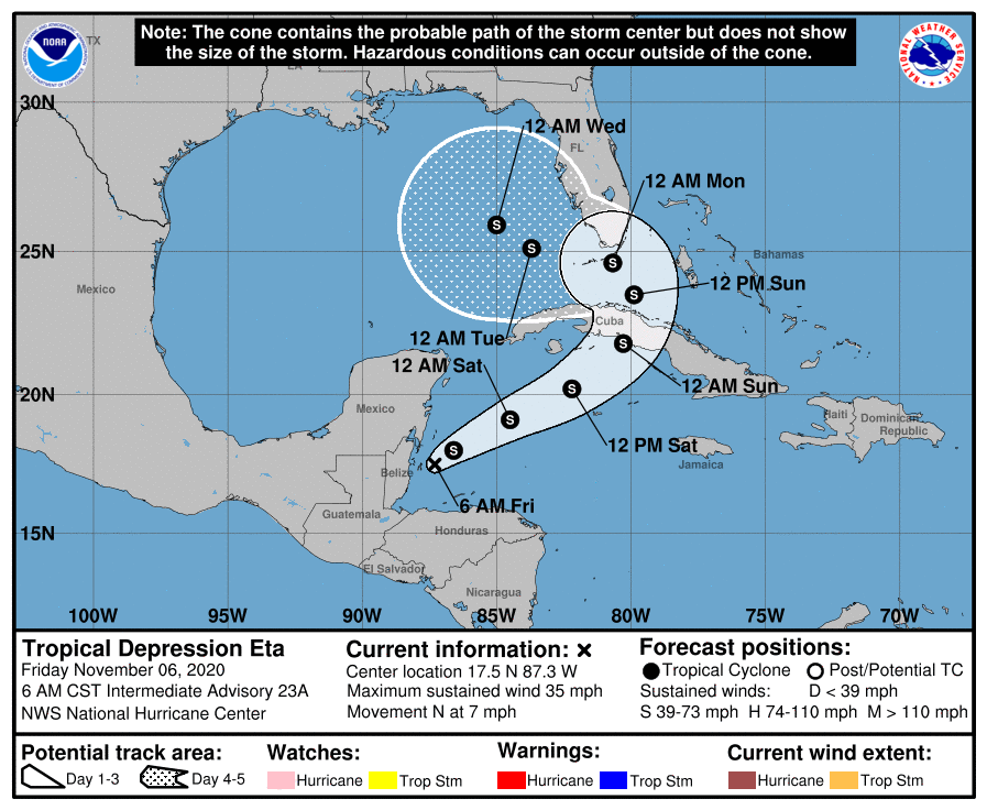
We don’t expect Eta to intensify significantly, but nevertheless it will be a tropical storm, capable of doing tropical storm things for Cuba and South Florida. The end game here should see Eta picked up and lifted north into the eastern Gulf Coast later next week as our cold front slides that way, probably still as a tropical storm.

After a bit more drier air, a warmer, more humid weekend looms

Good morning. If you’ve signed up for email updates from Space City Weather, we know that some of you have been experiencing formatting issues on both your mobile phones and desktops. We’re not sure exactly what is causing this problem, but are aware of it, and are troubleshooting. In the meantime, you can always just click the headline in the email to go to the website. In terms of our weather, not much has changed—we’re still expecting lots of sunshine, and warmer temperatures this weekend.

Thursday

It’s much warmer across the region this morning, with lows in the low 60s in the city and partly cloudy skies. Expect high temperatures to reach around 80 degrees later today, under mostly sunny skies. Although it is fairly humid outside, a pocket of drier air should move into the area later today, and this should allow for a slightly cooler nights. I think most of Houston, except for the coast, will probably dip into the 50s under partly cloudy skies tonight.

Houston will enjoy a pleasant fall night on Thursday. (Pivotal Weather)

Friday

This should be a pretty glorious day with highs in the upper 70s to 80 degrees, sunny skies, and reasonably dry air. Lows Friday night should be a degree or two warmer than Thursday night.

Saturday and Sunday

By this weekend we’re going to see a more pronounced onshore flow, and this will begin to ramp up humidity levels. I think daytime temperatures are still going to remain around 80 degrees, but nights will be warmer—in the mid- to upper-60s. I still expect skies to remain partly to mostly sunny, although the coast may see a few stray showers.

Houston will have full sunshine on Friday, and partly sunny weather thereafter. (Weather Bell)

Next week

The start of next week looks warm, with highs pushing into the mid-80s and more clouds. We start to see some slightly better rain chances on Monday and Tuesday in advance of a front, but right now I would not expect more than light showers. The front will cool us off, but it remains to be seen how much cooling will take place, and how long it will last. A stronger front may be in the cards for Friday or Saturday of next week.

Tropics

Hurricane Eta has wrought devastation in Nicaragua and Honduras. The storm’s center, now over Honduras, barely exists now, but it should move into the Caribbean Sea on Friday, and will pose a rainfall threat to Cuba and South Florida by Sunday. After that? The eastern half of the Gulf of Mexico will need to pay attention to the storm, which may be out at sea for another week or so before finally coming ashore.

Houston’s weather will be rather boring for awhile, and that’s not bad

Good morning. We stick to weather on this site—and so there are no politics here. But we would like to thank everyone in Houston, Texas, and the rest of the country who spent Tuesday working at poll locations, counting ballots late into the night and even today, and otherwise ensuring our nation’s free and fair elections. We should be proud of our ability to conduct an election in the midst of a pandemic, with record turnout.

Wednesday

The Houston region will warm up some today as high pressure that has provided us with clear and cool weather moves east. This will allow for a more pronounced flow of moisture into the metro region today, leading to moderately warmer nights and somewhat more humidity. As a result, we can expect highs today to reach into the upper 70s to 80 degrees beneath mostly sunny skies, and for lows to be about 10 degrees warmer than recent nights for most locations. Winds will be out of the southeast at 5 to 10 mph.

Thursday and Friday

The weather to end this week will basically remain in a stasis pattern as an upper-level low pressure system develops over the northwestern Gulf of Mexico. This will lead to the formation of some clouds on Thursday morning, and should help to arrest and possibly reverse the region’s warming trend. Highs both days will rise into the upper 70s to 80 degrees, but nighttime lows may drop back into the 50s for most of the region on Thursday and Friday nights. Despite the proximity of the upper-level low, however, I don’t think we’ll see much in the way of rain chances.

Temperature forecast for central Houston over the next week. (Weather Bell)

Saturday and Sunday

By this weekend I think it will be “game on” for the warming trend, and this will lead to considerably more humidity, with daytime highs in the upper 70s to low 80s, and nights warming into the mid- to upper-60s in Houston. Skies should remain mostly sunny.

Next week

When I look to the forecast for next week I can’t help but groan as it’s really not becoming all that much more clear. At this point some kind of front is likely to reach the coast on Tuesday, and bring a reasonable chance of light to moderate rain with it. But I can’t say with much confidence how much cool air will be arriving with the front, or how long it will stick—maybe a day or two? Then there is some evidence, which is far from overwhelming, for a stronger front toward the weekend. Weather forecasting isn’t perfect, folks, but I think it’s safe to say we do better than polls most days.

Tropics

Eta made landfall as a major hurricane on Tuesday, bringing life-threatening storm surge into Nicaragua, and lashing Central America with extremely heavy rainfall. The storm will meander across Honduras, and likely Guatemala, before turning northeast and moving back into the Caribbean Sea. I have not been able to find reliable reports of the devastation so far caused in Central America.

Eta’s track by Sunday becomes highly uncertain. (National Hurricane Center)

If you liked the uncertainty in our forecast for next week’s weather in Houston, you’ll love it for the future of Eta in about a week’s time. I think it is safe to say the storm will move toward Cuba this weekend, and then probably approach southern Florida.

We have real questions about how strong the storm will be at that time, and whether it begins to loop around in absence of any pronounced steering currents—perhaps somewhere in the southeastern Gulf of Mexico. Eta is definitely something for Florida and the southeastern United States to watch, but not something we need concern ourselves with in Texas.

Houston experiencing its coldest morning for awhile today

Good morning. Today is an important day for our republic, the one day a year when two halves come together to create something great. This tradition dates to the 1700s, and people often take time off from work to partake in this custom, walking up to a counter and making their choice around lunchtime. I am speaking, of course, of National Sandwich Day. Also, please do make sure you go vote in our election today, as the weather will provide no excuses.

Election Day

Temperatures this morning in Houston, in the low 40s for inland areas and upper 40s in the city, will probably be the region’s coolest for the next week. We’ll warm up fairly quickly, however, and the weather today will be, in a word, perfect. Highs will reach into the mid-70s, under mostly sunny skies. Winds will be light out of the east. Overnight lows on Tuesday night should be a few degrees warmer.

Tuesday morning lows are quite cool across the region. (Weather Bell)

Wednesday, Thursday, and Friday

These will be pleasant days, under the influence of a light east and southeasterly flow. In general, we expect mostly sunny skies, highs in the upper 70s to 80, and lows of around 60 in Houston—cooler inland, and warmer along the coast.

Saturday and Sunday

By this weekend a more pronounced southerly flow will raise humidity levels. Ultimately, high temperatures should hang around 80 degrees, but both Saturday and Sunday nights should be warmer, probably in the mid- or upper-60s.

Next week

This warming trend should continue until around Tuesday or Wednesday of next week, when some sort of front will trundle into the area. I still don’t have confidence in its timing or strength, but there is some hope it will bring us our first real chance of rainfall in quite some time.

A very powerful Hurricane Eta nears landfall on Tuesday morning. (NOAA)

Tropics

If you have not been paying attention to Hurricane Eta, it absolutely exploded in terms of intensity on Monday, and it will come ashore into Nicaragua today with Category-4 or -5 intensity winds. In addition, the storm will deliver devastating flooding in Nicaragua and Honduras. The storm is eerily similar in intensity to Hurricane Mitch, in 1998, which caused more than 11,000 fatalities.

By this weekend, after wreaking carnage in Central America, Eta should reemerge into the northwest Caribbean Sea, after which time it may threaten Cuba, Florida, or possibly the eastern Gulf of Mexico. It’s just too early to say much more.