Significant flash flooding ongoing in Houston this morning

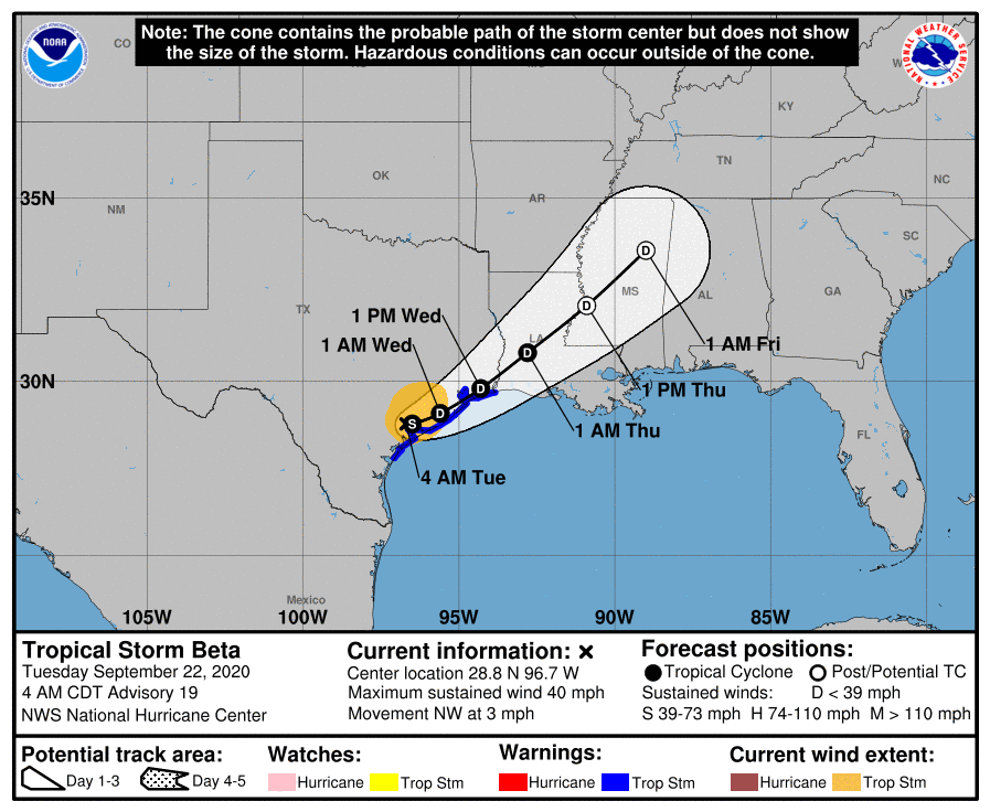
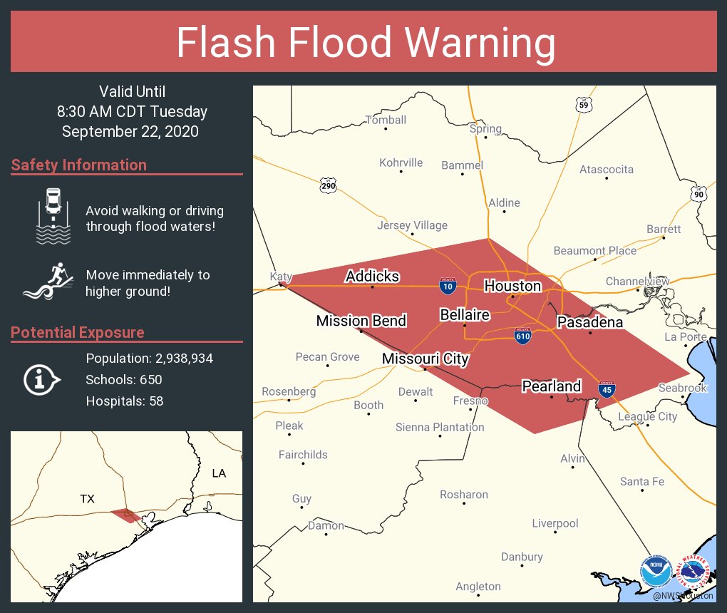
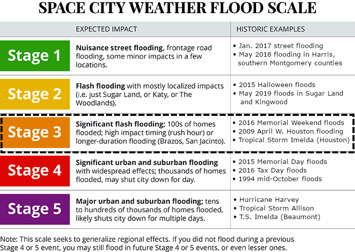
8:10 am CT Tuesday: Effective immediately, we are elevating our Flood Scale alert to Stage 3 for parts of the Houston metro area along, and south of Interstate 10. This is where the heaviest rain should again fall today and perhaps tonight as Tropical Storm Beta continues to pump moisture into the region. For areas further inland, we are maintaining a Stage 1 flood alert.

Space City Weather Flood Scale.

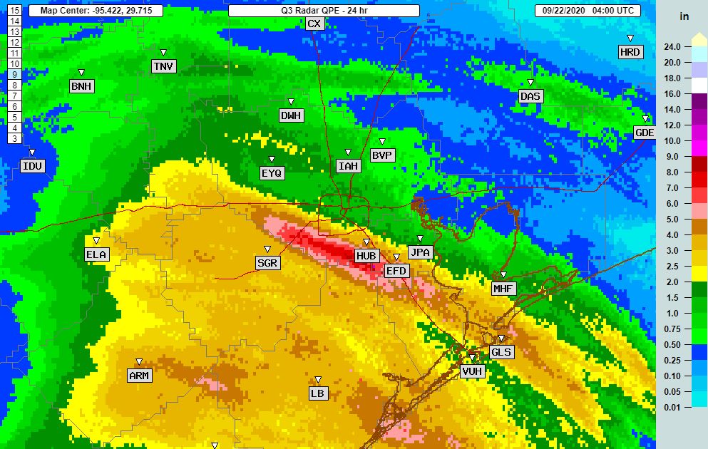
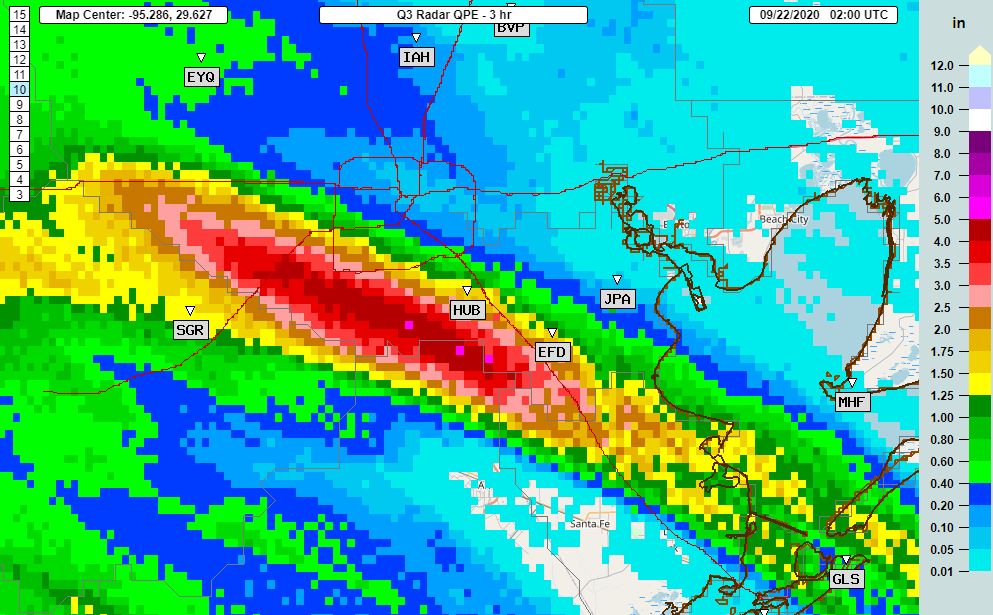
Why did we elevate the risk? For one, Beta produced more rains on Monday and Monday night than we generally anticipated, up to 10 to 12 inches in some locations. While this is not a catastrophic storm yet, it has produced widespread street flooding in central and southern parts of the Houston area. Many roads, including much of Highway 288, are impassable at this time. Residents are strongly encouraged to stay home today. Finally, many bayous in hard hit areas are at or near bankfull, meaning that we could see some home flooding today if heavy rains continue. The best web site to track the water level of your nearest bayou or creek is Harris County’s Flood Warning System.

Houston radar snapshot as of 7:55 am CT. (RadarScope)

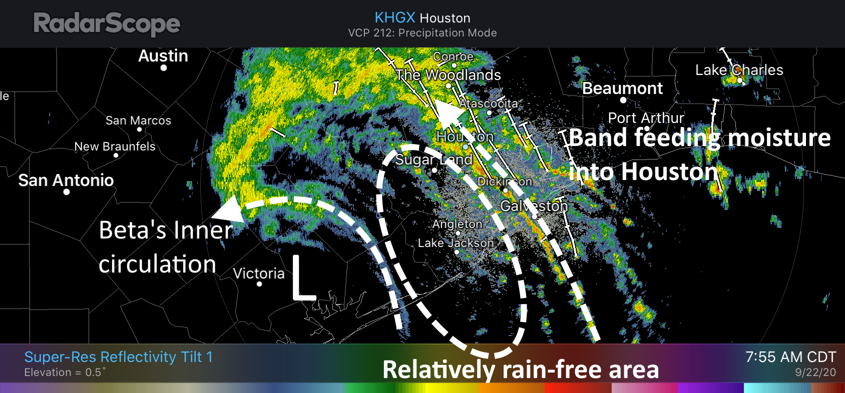
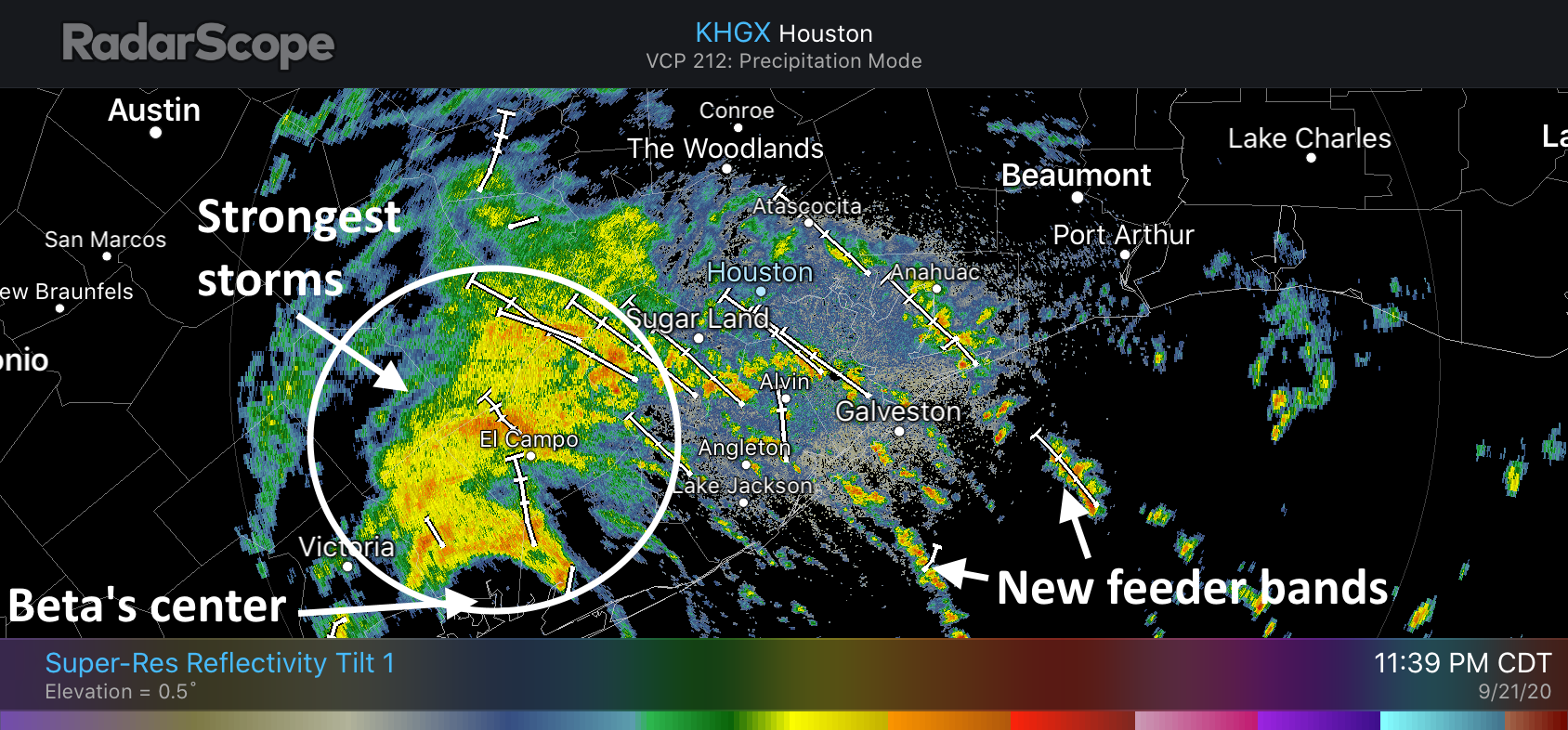
One of Beta’s strongest bands has again established itself along roughly the Interstate 45 corridor this morning, and this is dragging showers capable of producing 1 to 1.5 inches of rainfall an hour into the city, affecting some already hard-hit areas. This band appears to be lifting slowly north, and behind it there is an area largely free of rain. It’s possible this area of more stable air may move into Houston, providing a bit of a reprieve later this morning. But I’m making no promises on that.

Right now, I would generally expect 2 to 4 inches of additional rainfall across the Houston metro area today, but we cannot rule out higher bullseyes.

Our next update will come no later than 11 am CT.

Beta’s bands continue to impact Houston roadways and bayous

5:45am CT Tuesday: Good morning. We are continuing to closely monitor heavy rainfall in and around the Houston metro area due tropical moisture. Some areas south of Interstate 10 have received 5 to 10 inches of rainfall during the last 24 hours and more is in store today.

Tropical Storm Beta may or may not be a tropical storm any longer—the official forecast pegs it at 40 mph sustained winds, with fairly low confidence—but this matters little to the ongoing forecast. Its center has continued moving slowly inland this morning, and is probably located some few dozen miles northeast of Victoria Texas, along the Highway 59 corridor. The storm has drifted a little bit further inland than forecasters anticipated, and it should wobble around there for about 24 hours. After this time it should start to lift to the northeast, and pull away from the Houston metro area by later on Wednesday.

4am CT Tuesday track forecast for Tropical Storm Beta. (National Hurricane Center)

The biggest threat from this slow-moving tropical system remains rainfall. After widespread rainfall on Monday, the grounds and bayous south of, and along Interstate 10 are now saturated. Minor flooding is now occurring at some locations along Clear Creek and a high tide (at 5:43 am Tuesday) in concert with Beta’s lingering surge is not helping matters. Several other waterways, including Buffalo Bayou and lower South Mayde Creek are also experiencing some issues in West Houston.

Because areas of south and central Houston have received an additional 2 to 5 inches from Beta since midnight, the National Weather Service has issued a Flash Flood Warning until 8:30 am CT. If possible, please stay off roadways this morning in this warned area.

Flash Flood warning in effect until Tuesday at 8:30 am CT. (National Weather Service)

The overall pattern today should be similar to Monday, with bands of rainfall moving in to the Houston area. It is not clear where the strongest of these bands will set up, but radar trends this morning indicate they could be slightly more narrow than those seen on Monday. The likely effect of this is intermittently moderate to heavy rainfall. The good news, if we can find some, is that the heaviest of these storms are generally only dropping 1 to 1.5 inches of rain per hour. This is heavy rain, but not the sort of 2+ inches per hour rates that can quickly back up bayous and roadways. However the constancy of the rainfall adds up.

Right now I do not think Tuesday night will be quite as bad as Monday night, but our overall confidence in rainfall totals at this point is low. Worst case scenario, some areas could see an additional 5 to 10 inches of rainfall today and tonight. Most areas will probably see less.

Our next update will come by or before 9 am CT.

Storms over Houston metro area ease off a bit, but they’ll likely be back

11:55 pm Monday: Congratulations, everyone. We survived Monday—although for the southern half of Houston it was a rainy mess. Rainfall estimates show that some areas near the border between Harris County and Fort Bend and Brazoria counties received 6 to 8 inches of rain during the preceding 24 hours, and it has brought some waterways to bankfull. It did not help that the heavy rains on Monday night came just as a high tide was pushing into Galveston Bay, making it more difficult for area bayous to drain. Otherwise, as expected, areas north of Interstate 10 generally received 2 inches of rain or less.

Radar estimates of rainfall for Monday. Note the swath near Southern Harris County. (NOAA)

So far, even in the hardest hit areas, this has been a mostly street flooding event. But what happens next? We think the next 24 hours will produce plenty of precipitation as well. This is because although Tropical Storm Beta made landfall at 10 pm CT Monday on the southern end of Matagorda Bay, it’s center should now remain nearly stationary for the next 24 hours or so. This means the Houston region will lay within the storm’s northeast quadrant.

We’re most concerned about the areas that have already received 5 or more inches of rain during the preceding day (pink and reddish hues on the map above). As hoped, showers now moving into this area near midnight are lighter and a bit more scattered than earlier on Monday. The storm’s heaviest rains are now more tightly clustered near its center, further to the southwest of the Houston metro area.

Overview of Houston area radar at 11:40pm CT Monday. (RadarScope)

Some of our mesoscale models suggest this clumping of heavier rains could gradually build northeast toward Sugar Land (in a few hours) and Houston and the Interstate 45 corridor by around sunrise on Tuesday. I don’t have great confidence in these models, but it seems as plausible scenario as any. We may also see more feeder bands develop offshore and move inland into metro region during the overnight hours. Additional rainfall amounts of 3 to 6 inches for parts of Houston cannot be ruled out through Tuesday morning.

Our next update will come no later than 7 am CT on Tuesday.

Heavy rains have fallen this evening south and southwest of Houston

Good evening. Training bands of moderate-to-heavy rainfall from Tropical Storm Beta are continuing to move across the greater Houston area this evening. The heaviest rains from 6 to 9 pm fell generally to the south-southwest of Houston, from Friendswood and Pearland through Sugar Land. A few locations received 4 to 5 inches during this three-hour period and it is starting to back up bayous. Other parts of Houston have largely been spared.

Three hour rainfall estimates for 6 to 9pm CT Monday. (NOAA)

These southern areas appear to have won the Beta lottery this evening with a nearly stationary banding feature that is continuing to feed off moisture from the Gulf of Mexico. The National Weather Service has issued a flood advisory for this general region, suggesting an additional 1 to 2 inches of rainfall may occur over the next several hours. So far, the vast majority of area bayous and creeks remain within their banks. According to Harris County Jeff Lindner, here are the waterways of most concern at the moment:

  • Lower Keegans Bayou: overbanks at Roark…flooding is ongoing
  • Willow Waterhole: near bankfull at Westbury
  • Brays Bayou: water levels are within 2-5 feet of bankfull from Gressner Dr to Rice Blvd
  • Clear Creek: Near bankfull along the entire channel and overbanks near I-45
  • Turkey Creek: Within 3 ft of bankfull at FM 1959

Waterways aside, these heavy rains have created a dangerous situation on some area roadways. Tonight is not a great night to be out and about.

My read on the radar is that this prolonged banding feature that has been running up the Gulf Freeway for much of today and this evening, and ultimately bending into Sugar Land and now west Houston, is running out of steam. Offshore, the next band appears to be developing slightly to the north and east, and if this happens it should give some of the region’s aforementioned, hardest hit areas a reprieve in an hour or two.

Our next post will come by or before midnight to see whether I have read the radar correctly.