5:45am CT Tuesday: Good morning. We are continuing to closely monitor heavy rainfall in and around the Houston metro area due tropical moisture. Some areas south of Interstate 10 have received 5 to 10 inches of rainfall during the last 24 hours and more is in store today.
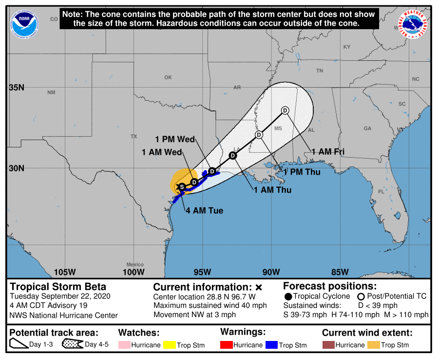
Tropical Storm Beta may or may not be a tropical storm any longer—the official forecast pegs it at 40 mph sustained winds, with fairly low confidence—but this matters little to the ongoing forecast. Its center has continued moving slowly inland this morning, and is probably located some few dozen miles northeast of Victoria Texas, along the Highway 59 corridor. The storm has drifted a little bit further inland than forecasters anticipated, and it should wobble around there for about 24 hours. After this time it should start to lift to the northeast, and pull away from the Houston metro area by later on Wednesday.
The biggest threat from this slow-moving tropical system remains rainfall. After widespread rainfall on Monday, the grounds and bayous south of, and along Interstate 10 are now saturated. Minor flooding is now occurring at some locations along Clear Creek and a high tide (at 5:43 am Tuesday) in concert with Beta’s lingering surge is not helping matters. Several other waterways, including Buffalo Bayou and lower South Mayde Creek are also experiencing some issues in West Houston.
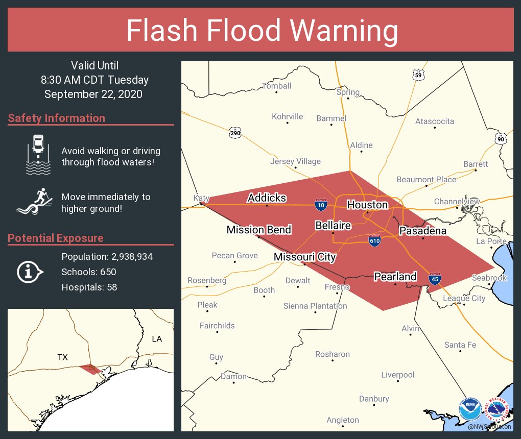
Because areas of south and central Houston have received an additional 2 to 5 inches from Beta since midnight, the National Weather Service has issued a Flash Flood Warning until 8:30 am CT. If possible, please stay off roadways this morning in this warned area.
The overall pattern today should be similar to Monday, with bands of rainfall moving in to the Houston area. It is not clear where the strongest of these bands will set up, but radar trends this morning indicate they could be slightly more narrow than those seen on Monday. The likely effect of this is intermittently moderate to heavy rainfall. The good news, if we can find some, is that the heaviest of these storms are generally only dropping 1 to 1.5 inches of rain per hour. This is heavy rain, but not the sort of 2+ inches per hour rates that can quickly back up bayous and roadways. However the constancy of the rainfall adds up.
Right now I do not think Tuesday night will be quite as bad as Monday night, but our overall confidence in rainfall totals at this point is low. Worst case scenario, some areas could see an additional 5 to 10 inches of rainfall today and tonight. Most areas will probably see less.
Our next update will come by or before 9 am CT.

Thank you for the reports. Interesting that a year or two ago the forecasters were calling for a 5 – 7 year drought. Nice to have you reporting the facts and not hyping.
You have been hard at it, and I really appreciate your efforts. Usually we talk about Beta Testing a new product — but you’re the one being tested by Beta this time.
My backyard weather station has registered a little over 10 inches of rain in the past 24hours. The streets are flooded, as we are sitting in our own “private island”
Vanessa J, which watershed are you in?
Thank you so much for your hard work. We appreciate you so much!
What causes the rain gap south and east of the center of the storm?
Any more details about what we could expect along Clear Creek from Friendswood to League City in terms of rainfall and creek levels? Thanks
A little over 5″ in the last 12 hours near Ellington. A quick walk around the subdivision this morning showed the drainage ditch is handling it just fine, though I didn’t appreciate the rain waking me up at 4:48.
FYI, at 4:45 am this morning I observed that Braes Bayou at Stella Link was already overflowing its banks at a reported 39 feet (41 feet is the official minimal flooding level). South Braeswood at Stella Link was already impassable and Braes Bayou has continued to rise. However, once inside the Texas Medical Center, the roads were not flooded.
According to the stream elevation chart on the Harris County Flood Warning System web site, flooding is possible at 45.30′ and likely at 48.40′. The stream level exceeded 41′ at around 9:35 last night. The highest the gauge has recorded is 43.94′. I live one block south of that intersection. I have observed no flooding.
Do you have info on flooding conditions in Montrose area of Houston?
Montrose barely got 4” of rain so far it’s not flooded
For the many people asking about local flooding, https://www.harriscountyfws.org/ is a good resource. The default view shows rainfall amounts, but click on the “Channel Status” checkbox for real-time bayou levels across the area. Hover your mouse over a meter icon for more detailed info for an area.
I live off of clear creek and I wouldn’t say the flooding we are experiencing is minor. Not major either but somewhere in between. It’s definitely more than I was prepared for. Hoping things dry out today.
7 ½ inches so far here in Sienna Plantation.
Any way you could add in the historical, like Harvey, levels of bayous along with what they are currently? That way people might not compare every rain event to those historic levels. Unfortunately, as expected, the HCFCD website doesn’t easily provide this comparative data and of course no major network will promote anything less than pandemonium to sell ad space.
This is the link where I check Clear Creek by my house. It shows historic crests so you can compare current levels to other major events. Just find the location you want to inspect.
https://water.weather.gov/ahps2/hydrograph.php?wfo=HGX&gage=hcct2
Will there be flooding on Wednesday?
Good morning. Thanks for the updates. I am in the Beaumont area. What do you guys predict for us from this system?
10.88 inches in the last 24 hours. Beamer and El Dorado. 5.88 over night.
This seems to be causing more flooding than was predicted.
Indeed it is.
5 inches in Cypress as alfar as Tuesday morning
6.5″ since Sunday here in Dickinson. No real flooding though, which is good.