June heat continues before rain chances return Saturday or Sunday

Our hot and sunny weather will continue for a few more days before high pressure moves away, and the pattern begins to—slowly, probably—change this weekend. Any widespread rainfall will likely have to wait until next week, however.

Wednesday

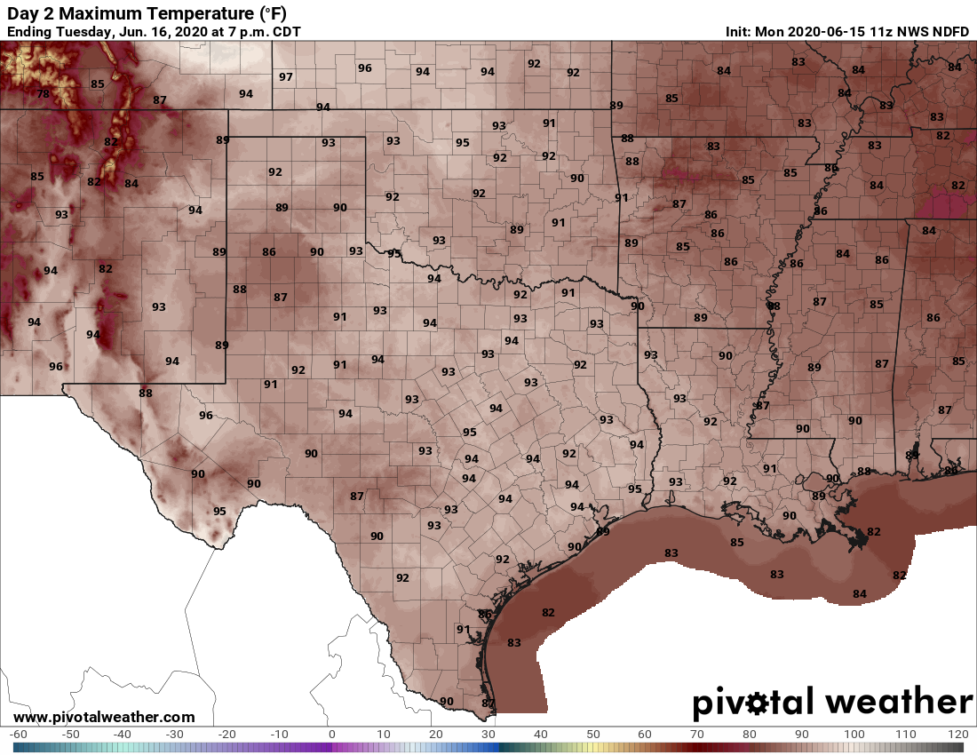
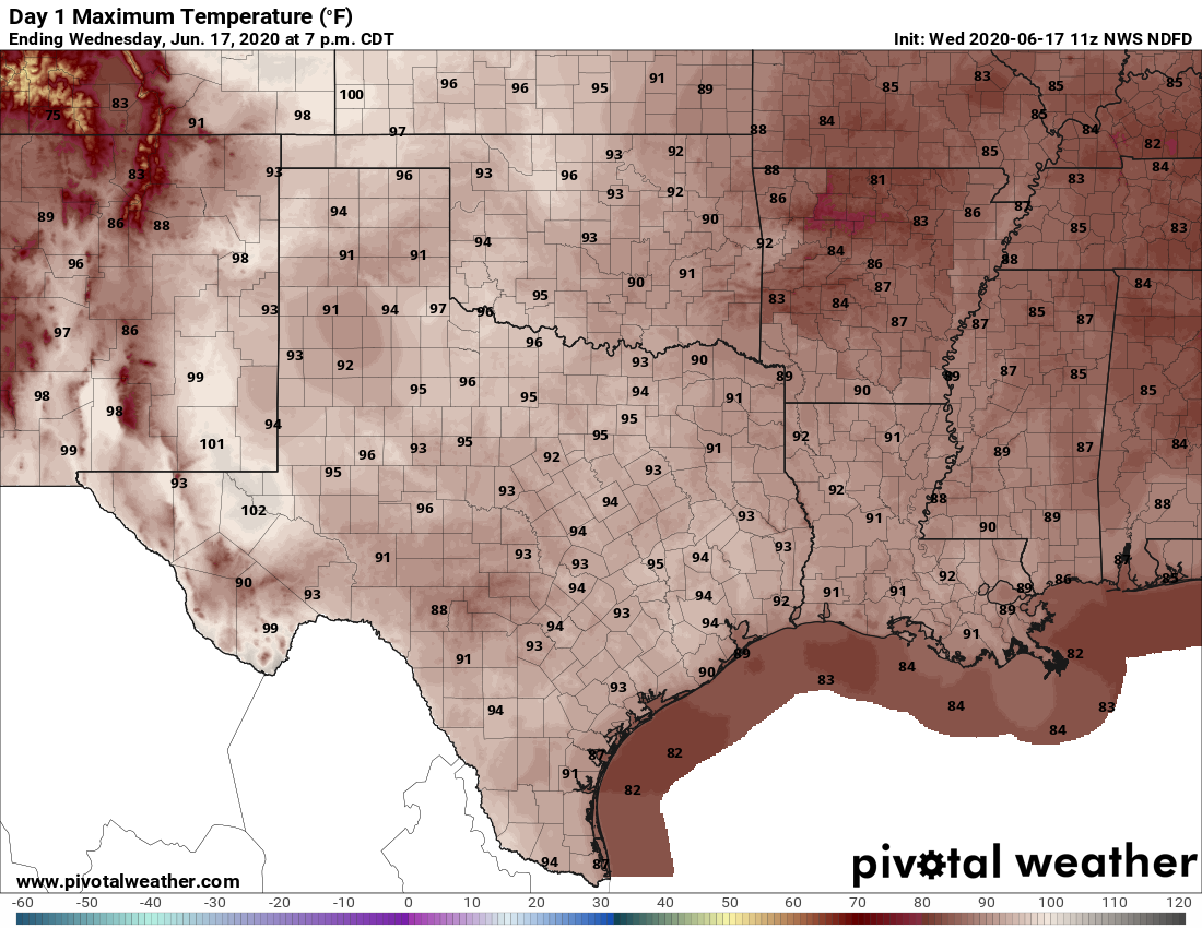
With sinking air, we will see lots of blue skies today. Although a few isolated showers may develop east of the city, rain chances are near zero over Houston, and highs are going to rise into the low to mid-90s. This is the type of pattern that, were we in August, highs would push up near 100 degrees. Winds will be generally light, out of the south at 5 to 10mph. Overnight low temperatures will unlikely fall below the mid-70s.

Expect hot conditions today across Texas. (Pivotal Weather)

Thursday and Friday

More of the same.

Saturday

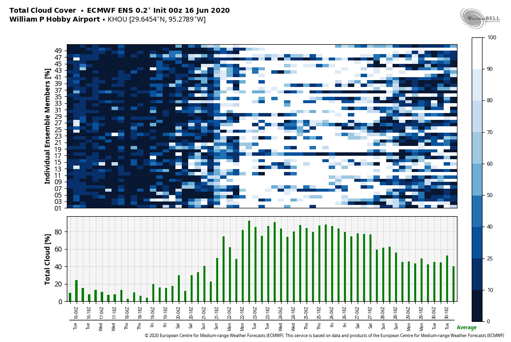
By this weekend, the ridge of high pressure that has dominated our weather for more than a week should begin to weaken, and this will allow a more pronounced flow of moisture off the Gulf of Mexico. This will eventually lead to development of some clouds and rain showers. But it’s not clear how much of that will happen on Saturday. So for now, expect a partly to mostly sunny day, with highs in low 90s, and perhaps a 20 or 30 percent chance of rain.

See full post

Houston will see plenty of sunshine until Saturday or Sunday

As I type this, it is 5:55am and already beginning to get light outside. Some readers will surely disagree, but such early sunrises in June always play havoc with my sleep schedule. Fortunately (for me, at least), we have already passed the earliest sunrise of the year, and beginning Thursday the sunrise time for Houston will move from 6:20am to 6:21am, and grow about 20 seconds later every day.

Tuesday

With decent atmospheric moisture levels in place, we may again see some scattered activity fire up on the radar this afternoon along the sea breeze. Most of the modeling indicates any storms should be fairly short-lived, with better chances to the east and northeast of Houston. The bottom line is that although rain chances are low today—probably around 20 percent or less—they are higher than most of the rest of the week. Highs should reach the low- to mid-90s with mostly sunny skies.

Houston should see mostly sunny skies through Friday or Saturday. (Weather Bell)

Wednesday, Thursday, and Friday

Not much to say about these days with mostly sunny skies, highs in the low- to mid-90s and lows in the 70s. High pressure will probably prevent any showers from popping up.

Saturday and Sunday

This pattern begins to change this weekend as the high pressure system over our region finally begins to weaken, allowing for the development of some scattered clouds on Saturday, and perhaps more widespread clouds on Sunday. This may also lead to some better rain chances in the 30 to 40 percent range, although accumulations looks modest. Highs will remain in the low 90s.

Next week

Both the European and GFS model are indicating the possibility of more rainfall next week, perhaps somewhere in the Tuesday through Thursday time frame. It’s possible that we may see some heavy rainfall, but the details are sketchy at this point.

High pressure holds sway until rain chances return this weekend

Good morning. High pressure will dominate our weather this week, but it won’t be completely oppressive. Summertime highs typically peak in the upper 90s and lows in the upper 70s to 80 degrees in August. But this week, we should see more June-like weather with highs in the low- to mid-90s, with overnight temperatures in the low- to mid-70s. Oh, and if you’ve stepped outside this morning, you’ve already noticed that the humidity is baaack. That should be a constant companion for at least the next three months. Speaking of heat and humidity, if you have not yet signed up for Reliant’s AC Sweepstakes, you’re missing out on a chance to win a free AC System.

Monday

Some isolated showers developed to the southwest and northeast of Houston on Sunday, and we should see a similar pattern today as some higher atmospheric moisture levels help a few showers to form. While we will probably see these fast-moving showers this afternoon, most of us will just be sunny. Look for highs in the low 90s with light southeast winds. Overnight lows should fall below 75 degrees for most areas except the coast.

Texas will be in the 90s on Tuesday. At least it’s not the 100s yet. (Pivotal Weather)

Tuesday

A similar day to Monday, with a chance of isolated showers popping up during the afternoon hours. Highs should reach the low- to mid-90s. Winds will be calm, to very slight from the southeast. Between the lack of wind, and the high humidity, it will feel very warm during the afternoon hours.

See full post

Nothing but sunshine ahead for Houston

Since Wednesday’s cold front, Houston has had 50 consecutive hours of dewpoints below 60°, which continue as of 7 AM Friday. Recall, dewpoint is a much better gauge of “comfort” in summer than relative humidity, and for Houston anything below 65° generally feels really nice this time of year. Anything in the 50s is very comfortable. To put in context how rare an event this is in Houston in summer. We have only done 40 consecutive hours of dewpoints in the 50s in June, July, or August two other times since Bush Airport was established as the official reporting station for Houston in 1969:

  • June 8-9, 1996 (43 consecutive hours)
  • June 24-28, 1974 (110 (!) consecutive hours)

It appears that this one will place firmly 2nd on the list. This air mass would be a first ballot inductee to the Hall of Fame of Comfort for Houston summers. And it continues.

We do have a couple things to monitor. This dry weather is going to have an impact on soil moisture in much of Texas. We’ll discuss that more in-depth next week. In addition to that, this dry, offshore breeze is certainly aggravating for allergy sufferers (raises hand). But other than that, we have little to talk about.

So in lieu of much text today, our forecast will be shared primarily in gif form.

Today & weekend

It will be tough to let go of the current weather pattern. Thankfully, this weekend won’t be too bad!

It’s my birthday weekend, and the humidity will remain low. This is how I’m feeling.

Expect highs in the 90s and lows in the 60s or low 70s this weekend, with continued low humidity for June. Sunshine and nil rain chances.

Full sun, a week out from the solstice? Load up on sunscreen this weekend.

Next week

Onshore winds resume Monday, and that means our friendly neighborhood Houston humidity will be on the rise.

Humidity begins to return next week…

But it won’t be that bad of a week.

“Won’t be so bad” is a relative phrase.

Alright, yeah, it will end up being a pretty hot week. Look for mid-90s at least, with lows in the 70s.

By the middle of next week, it’s likely to feel like summer in all its glory here.

The next chance of any meaningful rain at all, outside of a localized downpour? Maybe next weekend?

The 90s and “No Rain:” A Blind Melon forecast.

We’ll check back in with you on Monday with more. Enjoy the weekend!