Good morning. Although rain chances will never be too far away this week, neither will we have rain every day. Instead, we’ll see a mix of sunshine and clouds, with highs generally in the low 90s. When you combine this with a lack of tropical activity, I count that as a “win” for Houston’s weather in mid-July when things can sometimes get nasty hot or floody.
Monday
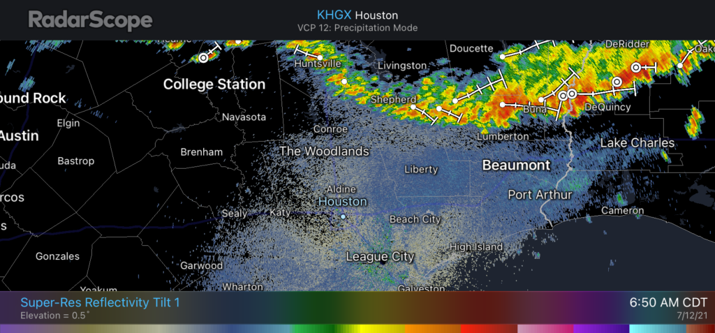
With that said, some storms will be possible today, especially north of Interstate 10 as a slow moving line of showers sags southward. Most modeling guidance suggests these storms will weaken as they move into Liberty and Montgomery counties, and progress toward Houston this morning. Otherwise, expect partly sunny skies with highs in the low 90s with light winds. Lows tonight should be in the mid- to upper-70s for most areas, with rain chances falling back to zero.
Storms north of Houston should sag south today, and weaken. (RadarScope)
Tuesday and Wednesday
These will be a pair of mostly sunny days for Houston, with highs generally in the low 90s. Winds will be relatively light at the surface, but a southeasterly flow in the mid-levels of the atmosphere will ensure there is plenty of moisture. This means that we may seem scattered showers during the afternoon hours, triggered by the sea breeze moving inland from the Gulf of Mexico. Any developing storms should be fairly short lived.
Thursday and Friday
For now I expect the overall pattern of days in the low 90s to continue, with a smattering of afternoon showers. There are some hints in the models that we may see some slightly better storm chances on Friday afternoon and evening, but this is not something I feel overly confident in predicting, so we’ll watch it for you.
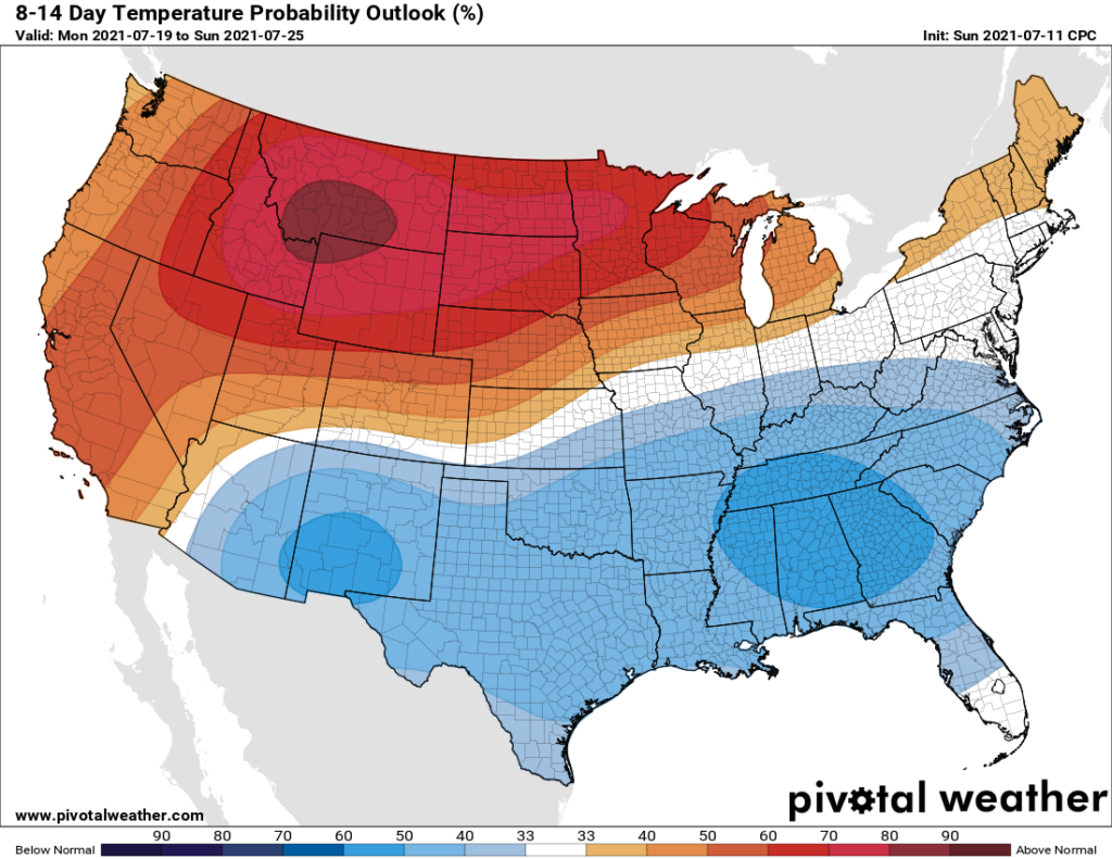
Cooler than normal temperatures for the second half of July? We’ll take it. (Pivotal Weather)
Saturday and Sunday
We’ll carry highs in the low to mid-90s over into the weekend, with more afternoon shower chances due to the sea breeze. The weekend forecast is subject to change, of course, but right now it should bring fairly typical summertime weather to Houston. By now you know the drill for what that means—heat, humidity, and mosquitoes.
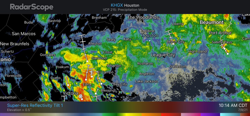
Hi all, just a quick update to say that this morning’s storms are winding down over the Houston metro area as anticipated. Although we still expect intermittent moderate to heavy rainfall throughout the early afternoon hours, the general trend toward less coverage and less intense rainfall rates should continue. Area roadways and bayous are generally handling this precipitation just fine. Even better: rain chances will fall back significantly this evening and through the weekend.
Houston’s radar signature at 10:14am CT shows weakening storms over Houston. (RadarScope)
Unfortunately the same cannot be said right now for the Coastal Bend area, from Rockport to Matagorda Bay, where heavy rains are continuing this morning and may do so for the next several hours. But that area, too, should finally see a reprieve later this afternoon and evening as a low pressure system in South Texas continues to move away from the region.
Have a great weekend, everyone, and enjoy the sunshine when it returns.
Well, the rains of last night didn’t get going until very late in any organized capacity. So the significant flooding feared last night southwest of Houston never materialized. That’s good news for sure. But that has changed this morning.
This morning
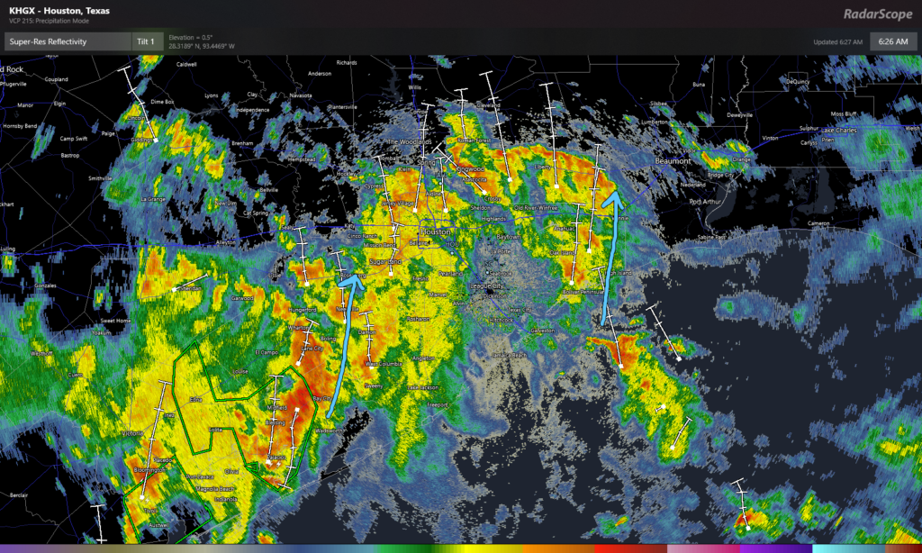
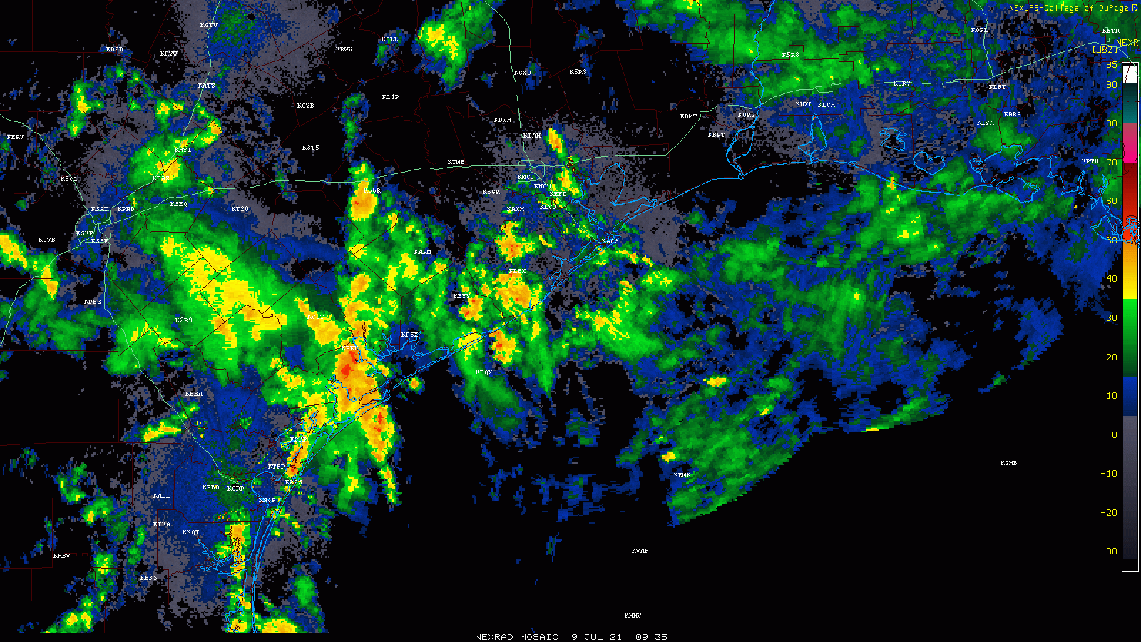
We have a pretty healthy area of rainfall this morning that extends from The Woodlands south to the coast. This started south of the area and has migrated north, and flood advisories are posted for Brazoria County, Brazos Bend State Park, and just east of Bay City in Matagorda County, as of 6:30 A.M. A new flood advisory was just hoisted for most of Houston inside the Beltway, Sugar Land, Kingwood, and Baytown as well. Also, a Flash Flood Warning is in effect for Jackson and Matagorda Counties (west of Bay City) through at least 9:30 AM.
As of 6:30 A.M., areas of heavy rain are lifting north across much of the area, most heavily concentrated southwest of the city. (RadarScope)
Rainfall is occurring right now at the rate of 2 to 3 inches an hour at its worst. Things are moving enough to keep the heaviest rain from falling over the same area for long enough to cause serious problems, but with wide areas of heavy rainfall around, it would seem that some street flooding is going to be likely in spots this morning, especially in the western half of the metro area. Additionally, heavy rain is clobbering western Matagorda County this morning, so folks down there and into Wharton County should expect areas of flooding over the next few hours. That particular area of rain may also get into Fort Bend County later this morning as well, so please be on the lookout for areas of street flooding.
The rain is all lifting generally due north, with some “noise” within the overall rain. This should prevent the heaviest rain from settling over any one area for too, too long. Still, it will likely be enough for some street flooding in spots. (College of DuPage)
Everything is moving generally due north. Again, this setup should prevent any one area from seeing so much rain at one time to cause serious problems. We are going to refrain from invoking the Space City Weather Flood Scale this morning for that reason (and given a few radar trends here late). This is a ripe street flooding setup for scattered areas, but it shouldn’t be too out of the ordinary for us. Just please use caution and give yourself extra time if you are commuting or you must be out and about this morning.
Eric or I will have another update on the rainfall situation before Noon today.
Rest of today
Look for this mess to gradually begin to wind down. The rain may actually not so much exit as “thin out” in place today. Coverage of showers will probably diminish beginning early to mid-afternoon and by evening, just some isolated downpours should be expected. Highs will likely be in the 80s for most spots.
Total rainfall between now and evening will be 1 to 3 inches on average, with some smaller, highly localized areas perhaps seeing as much as 4 to 6 inches, especially southwest of Houston and Sugar Land. Areas east of Houston and down toward Galveston may see a bit less total rain.
Saturday
The good news is that the weekend should see things begin to finally unwind a bit over Texas. This doesn’t mean bone dry every day, but this does mean that showers will ease back appreciably and we should return to some element of “normal summer.” We will go from widespread showers and storms like we’ve been having to more scattered showers and storms tomorrow. Look for highs near 90° after morning lows in the 70s.
Sunday
There is a chance that the vast majority of the area stays dry on Sunday. It will probably be sunny and hot and humid, with highs back up into the low-90s. Sea breeze showers may be the only game in town and those may even be a bit spotty. The best chance for anything organized will likely be north of Huntsville as yet another front drops into Texas Sunday afternoon.
Next week
Sunday’s cold front will try to nudge closer to our area Monday, which means we should see more numerous showers and storms. This will be especially true north of I-10 I think. So be prepared for a wet start to the week. Fortunately, that front pretty much washes out over the state to our north by Tuesday, meaning we can resume “typical summer” for most of next week. I would expect sun, clouds, low-90s by day, mid to upper-70s by night, and the requisite 20 to 40 percent coverage of showers each afternoon with daytime heating and the sea breeze. Days with less rain coverage could be a little hotter, days with more a little cooler.
The tropics look quiet Gulf and Atlantic-wide for the next 7 to 10 days. Our first real Saharan dust event of the season may occur Monday and Tuesday, so be on the lookout for that. Additional dust may arrive late next week. We’ll update you more on Tuesday when our weekly Eye on the Tropics series resumes.
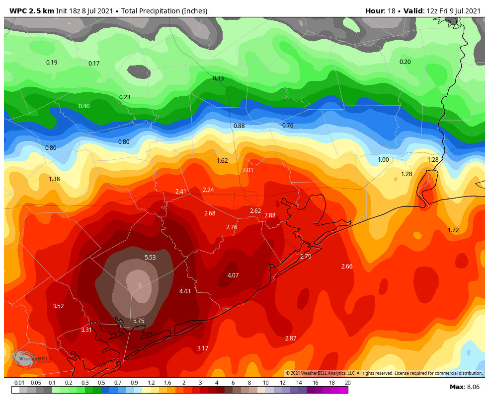
Eric and I just want to provide a quick update on the situation that is expected to evolve tonight southwest of the Houston metro area. There have been a few things that have come together today to lead us to think a significant thump of rain is possible in the Matagorda Bay area, extending into Wharton and possibly southern Fort Bend and Brazoria Counties at times. For the vast majority of the Houston metro area, periods of rain are expected, some of which could be heavy, especially in the southern half of the metro area. But serious, widespread flooding is not a concern for us at this time.
How much rain is expected?
As of right now, the thinking is that a general 4 to 8 inches of rain will fall between this evening and tomorrow morning for those areas in Matagorda, Wharton, and Jackson Counties.
Rainfall expected between this evening and Friday morning will be significant in the Matagorda Bay area. (Weather Bell)
There are a couple models we utilize for higher resolution in these types of events that are spitting out some pretty hefty totals, in excess of 10 to 15 inches. So in a worst case scenario, we could be talking about some pretty big rain totals down there. Some of the heavier rains could extend into southern Fort Bend, Brazoria, or Colorado Counties. Galveston County could be on the fringe of heavier rain at times also.
Why is this a problem?
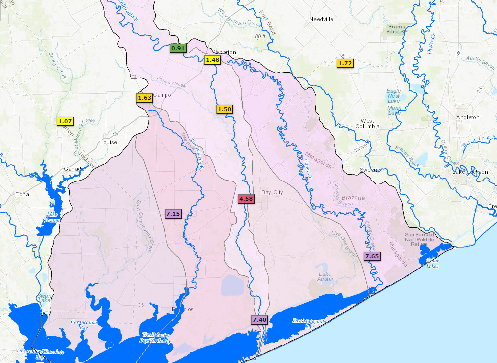
Besides the obvious reason that 8 to 10 inches or more is a lot of rain, the area just southwest of the Houston metro is especially vulnerable right now to flash flooding. Gauge data from the Lower Colorado River Authority (LCRA) shows that once you get close to Bay City, 72 hour rainfall totals have been up over 4 to 7 inches.
LCRA rain totals in excess of 7 inches have been reported in the Matagorda Bay area over the last 3 days. (LCRA)
Basically, an area that has seen this much rain already cannot handle 8 to 10 inches or more of it, so flash flooding is very likely to begin quickly as heavy rain falls.
Could the rain forecast change?
Absolutely. Models are pretty locked in on the region of greatest impact tonight (southwest of Houston), but their performance has struggled at times this week. We are dealing with a slow moving non-tropical system that is behaving like a tropical system. There’s inherent uncertainty on the finer details of the forecast, but for the most part we know that heavy rain is likely in spots, primarily southwest of Houston, and that heavy rain should be enough to cause flash flooding down that way.
Is there a chance this shifts to the Houston area?
As noted above, forecasts can change of course. But right now we feel pretty confident that the risk of serious flooding will not expand into the Houston metro area. Modeling is in good agreement on this, the meteorological variables are best aligned for heavy rain to the southwest, and those areas have had much more rain than the Houston metro has over the last 3 days. That doesn’t mean there won’t be periods of heavy rain in spots tonight. That also doesn’t mean that we won’t have any street flooding issues to contend with. Those are possible, as they always are when heavy downpours are forecast. But we do not expect serious, widespread flooding in Houston.
Why no flood scale alert?
This is a little trickier to answer, but basically since we don’t expect more than some nuisance street flooding in the Houston metro area right now, we are holding back the flood scale. At best it would be a Stage 1 for Houston. But for Matagorda, this would be higher than that, so we don’t want to confuse people southwest of Houston, needlessly panic the bulk of our readers in the Houston metro area, or send any kind of mixed message in general.
The bottom line is: Heavy rain is possible anywhere tonight. Street flooding is always a possibility, though we don’t believe it will be a huge deal in Houston. Significant, potentially widespread flooding is possible in Wharton, Jackson, and Matagorda Counties.
How does Friday look?
Without getting into too much detail: Expect scattered showers and thunderstorms, but the overall coverage of the rain should begin to decrease again tomorrow, as previously expected. We will have the latest for you on that in the morning.