August doing as August does: heat, humidity, and tropics acting up

For those of you who have lived through August a time or two in Houston, you’ll know there’s really not much escaping the heat. Fortunately, we’re not going to fall under a classic heat dome this week, so highs should remain below the triple digits. But there will be enough high pressure to keep rain chances fairly low. The bottom line is that it’s an easy forecast: hot, humid, with scattered afternoon rain chances. The tropics are more interesting, so we’ll discuss them below as well.

Monday

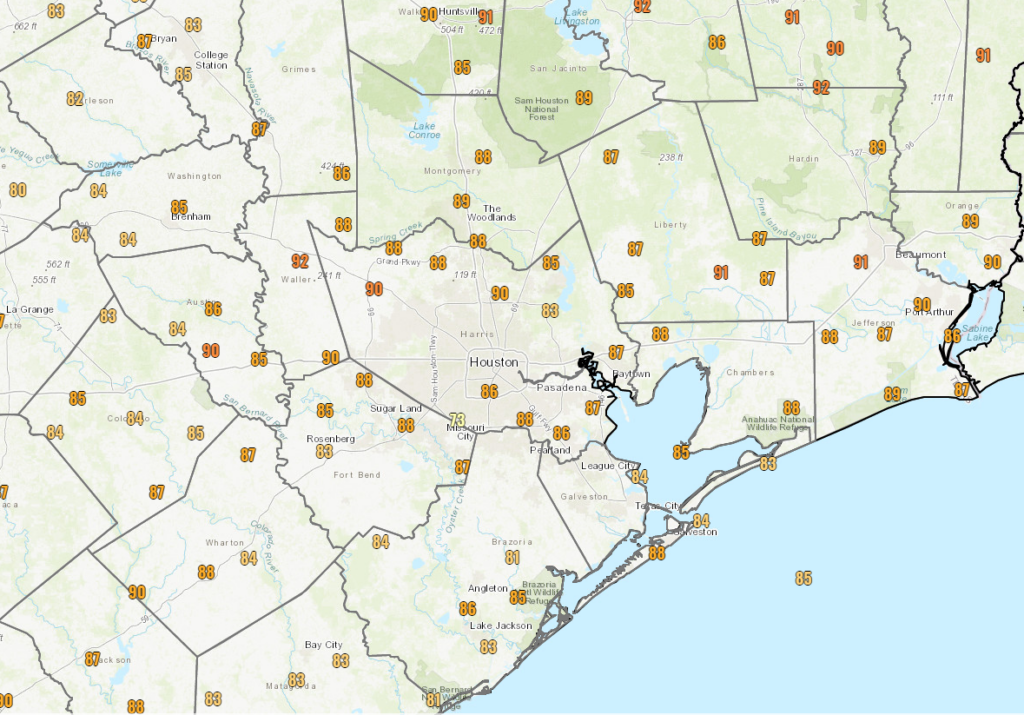
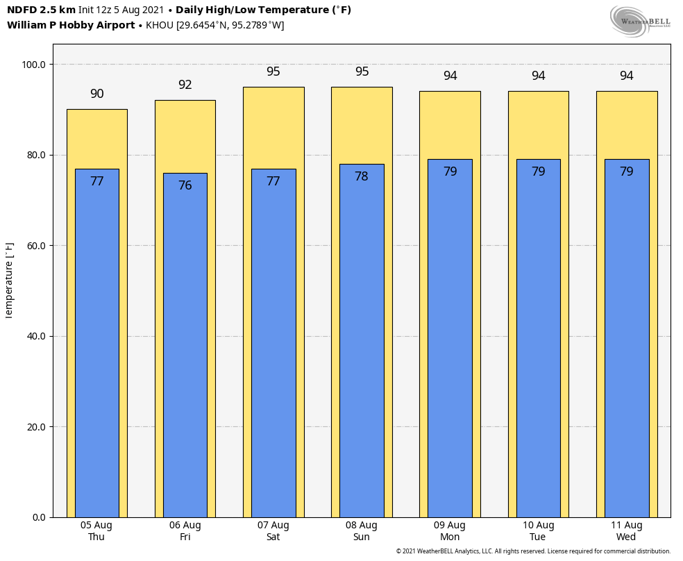
Did you like Sunday’s weather? Because that is what in the cards for today, with highs in the mid-90s and partly to mostly sunny skies. Most of the area has about a one-in-four chance of seeing a brief shower later this afternoon as the sea breeze gets fired up. Winds will be out of the south, gusting up to 20 mph later this afternoon. Overnight lows may briefly drop below 80 degrees overnight, but will remain warm and sticky.

High temperature forecast for Monday. (Weather Bell)

Tuesday through Friday

Right now we just don’t see much variability in the forecast through Friday. So for now, expect Groundhog Day-like weather, except for the odd shower that pops up during the afternoon hours.

Saturday and Sunday

Maybe this pattern changes by the weekend, but more likely it probably won’t. So expect to see more partly sunny skies this weekend, with highs in the mid 90s, and a few stray showers. We are in the middle of August, and this is the real Houston weather we all know and hate. Love! I mean love. This is the real Houston weather we all know and love. Yeah. That’s what I mean.

Tropics

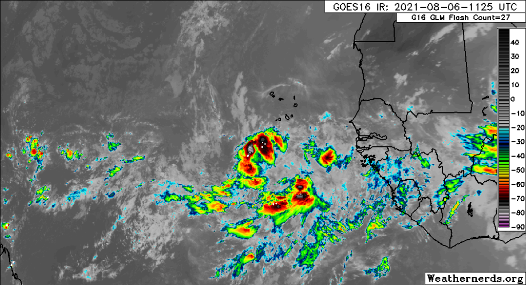
It has been exactly one month since the demise of Hurricane Elsa, and it sure has been a nice break in the Atlantic tropics. But alas, all good things must come to an end and now the tropics are very much coming to life. There are a couple of blobs on the National Hurricane Center’s five-day forecast.

Tropics outlook at 7 am CT Monday. (National Hurricane Center)

94L

We’ll start with the system that has a better chance of developing sooner. This system has about a 70 percent chance of becoming a tropical depression or storm within the next two days as it moves across the Caribbean islands. It should affect Puerto Rico, Hispaniola, Cuba, with rains, if not strong winds as well.

Invest 94L is going to bring rains and winds to the Caribbean Islands this week. (NCAR)

The jury is really out on whether 94L will strengthen much beyond a tropical storm as it must not only interact with these islands, and the overall pattern is not not ideal for intensification. But with that said the models have been under-selling 94L and it would not surprise me to see a strong tropical storm or modest hurricane near Cuba or South Florida by Saturday of this week.

After that? Perhaps it will ride up the Florida peninsula or track a bit further westward into the Gulf of Mexico before turning north. Regardless, at this time, direct effects for Texas seem a low probability. We’ll keep watching regardless.

93L

This system is far less organized, and will likely remain so for a while. However, as the tropical wave moves westward into the Caribbean Sea this weekend, it may eventually find more favorable conditions under which to organize. (Or it could very simply fade away). Regardless, it’s something to continue to watch if its holds together this week. Why? Because in Texas we never really want to see low pressure systems in the Caribbean Sea of Gulf of Mexico this time of year.

Turning back up the heat a bit this weekend in Houston

There was nothing inherently special about yesterday. We had some sun, some clouds, some haze from passing wildfire smoke. But we only managed to hit 89° officially at Bush Airport with dew point temperatures in the 60s for the majority of the day.

Thursday’s high temperatures ranged from the 80s to the low-90s, which really isn’t bad at all for August. (NOAA)

For August, that is almost as good as it gets around here. We are going to see changes this weekend, and a return to more typical summer weather should be expected over the next few days.

Friday

Today looks like a bit of a transition day. We bring back some humidity. We bring back some temperatures. And we bring back at least a smattering of hit or miss showers, downpours, or thunderstorms. Not everyone will get wet today, but about 30 to 40 percent of the region should see at least something. The highest odds for showers should be south and west of Houston initially, but some areas north and east may see some showers by afternoon. Highs will top off in the low-90s.

Weekend

We’ve had a lot of high clouds and passing moisture overhead this week that’s blocked out the sun at times. We should lose that for the weekend. Expect a return to mainly sunshine, high humidity, and highs in the low to mid-90s and lows in the 70s to near 80 degrees. It will feel like 105° or a bit hotter at times this weekend when you factor in the humidity.

The combination of temperature and humidity will make it feel closer to 105-106° in much of the area, with a few higher values possible. Saturday afternoon is shown here. It will feel like typical August this weekend. (Weather Bell)

Showers will again be possible both days, but coverage should slack off some, maybe peaking at 20 to 30 percent chances. In other words, if you see some rain, consider yourself lucky. There should be a slight breeze each afternoon but nothing too special.

Next week

There’s nothing particularly interesting about the weather next week as it stands right now. That’s good news in August and September, right? Expect daily chances of thunderstorms to perhaps increase a little each afternoon. But some areas will get drenched while others just hear the distant booms of atmospheric acoustics. Otherwise, expect sun and clouds with highs in the low to mid-90s each day and lows in the 70s, fairly typical for August.

Tropics

It’s tough to make much out of what’s happening in the Atlantic right now. There are a number of possible options for development over the next 5 to 7 days, and maybe one area that’s more clear cut than others (which is assigned a 60 percent chance to develop this morning according to the NHC). We’ll have an update on this Monday and Tuesday. But as of right now, there’s not any model or group of models that’s especially bullish on any one outcome, let alone one that brings it to the Gulf. So we have some time to watch.

The eastern Atlantic is sloppy this morning with a lot of clouds and showers but little organization and not a whole lot of model agreement on any one scenario panning out over the next few days. Worth watching, but nothing we’re overly concerned with at this time. (Weathernerds.org)

Following up on Eric’s post yesterday about NOAA’s seasonal forecast update, Colorado State followed suit on Thursday. They actually reduced their forecast a smidge, though they’re still calling for a season that ends up fairly active in the end. They also released a “subseasonal” outlook, which looks out at the next 2 weeks or so, and it unsurprisingly is calling for a period of above average activity in the Atlantic, something we’ve talked about for a little while now. So we’ll see. The setup in the Atlantic reminds me a bit of what we sometimes see in the western Caribbean or over Central America with what we call a “gyre.” You get a lot of storminess, models hinting at development, but little agreement on which portion of the broader mess becomes dominant. The good news is that it all continues to look mostly sloppy and disorganized for at least several more days.

Enjoy the low 90s, as the mercury rises this weekend

On Thursday NOAA released an updated version of its Atlantic season hurricane forecast and some media coverage framed it in a fairly intimidating way—suggesting the forecast had gotten “worse” or more dangerous in some way. The reality is that the forecast increased from an estimate of 13-20 named storms for this season to 15 to 21 named storms, and 6-10 hurricanes to 7 to 10 hurricanes.

(NOAA)

This “increase” simply reflects the fact that the early season was a little more active than anticipated, and that overall nothing has changed with regard to tropical activity for the remainder of the 2021 Atlantic hurricane season. Frankly, we already knew this was going to be an active season. And as Matt wrote on Tuesday, the tropics are now heating up on schedule, with the next six to eight weeks are the time of greatest concern for Texas. Fortunately, there are no immediate threats to the Gulf of Mexico and we’ll continue to take it day by day.

Thursday

A cluster of showers near Galveston Island is likely to remain confined near the coast this morning, as drier air remains aloft further inland. As high pressure over our region slides east of the region later today, we could see the development of scattered showers this afternoon, generally along and to the west of Interstate 45, but we don’t anticipate anything too organized. Skies will otherwise be partly to even mostly cloudy today, suppressing highs into the lower 90s. Rain chances should end overnight, with lows generally dropping into the upper 70s.

Friday

As the onshore flow begins to return on Friday there may be enough moisture to produce rain across about 30 to 40 percent of the area, but for the most part these should be short lived, light showers. Skies otherwise should be partly to mostly sunny, with highs in the low- to mid-90s.

Saturday and Sunday

Rain chances fall back to around 20 percent over the weekend, or less, as fairly typical August weather moves into the area. We can probably expect highs in the mid-90s with lots of sunshine, so plan your outdoor activities accordingly.

Houston is heading back to the mid-90s soon. (Weather Bell)

Next week

The forecast for next week looks fairly uneventful. We can probably expect days with highs in the low- to mid-90s, with spotty afternoon showers driven by the sea-breeze. Honestly, any time we’re not experiencing weather that’s extreme in August, I count it as a win.

We’ll have two “August nice” days before full-on summer returns

The August cool front has effectively moved down to the coast, and it has shoved most of the moisture offshore. As a result we should see a pair of pretty fine days—for August, of course—before the front washes out. Rain chances will increase somewhat by Friday but overall I still expect the weekend to be mostly sunny for most of us.

Wednesday

Light northerly winds are helping to bring moderately drier air into the region today, and this will help to limit rain chances. For inland areas, north of Interstate 10, rain chances are probably 10 percent or less. But closer to the coast, especially for areas such as Fort Bend, Brazoria, and Wharton counties, we could see storms pulse up this afternoon with daytime heating. Otherwise, highs today should be around 90 degrees for much of the area, with partly sunny skies. Overnight lows will probably be the lowest of the week, with some far inland areas perhaps seeing the upper 60s to low 70s. It will be a good evening for a walk or to otherwise get outdoors.

Thursday morning lows will be pleasant for August! (Weather Bell)

Thursday

This should be another reasonably nice August day, with mostly sunny skies and highs in the low 90s. Rain chances should be below 20 percent for the entire region.

Friday

As the onshore flow returns, so too will humidity and possibly some better rain coverage. Highs Friday will be in the mid-90s with mostly sunny skies. There probably is about a 40 percent chance of afternoon showers flaring up.

NOAA rain accumulation forecast for now through Friday. (Weather Bell)

Saturday and Sunday

There are still some questions about the weekend forecast, but my best guess at this point is hot and sunny weather, with highs in the mid-90s. Depending on the overall setup of the atmosphere we might see about a one-in-three chance of afternoon showers, or it could be lower than that. I hope to have that better nailed down for you tomorrow.

Next week

As we get deeper into August, it looks as though we’ll see fairly typical August-like weather next week. This means highs generally in the mid-90s, lots of sunshine, and the potential for scattered afternoon showers along the sea breeze.