On Thursday NOAA released an updated version of its Atlantic season hurricane forecast and some media coverage framed it in a fairly intimidating way—suggesting the forecast had gotten “worse” or more dangerous in some way. The reality is that the forecast increased from an estimate of 13-20 named storms for this season to 15 to 21 named storms, and 6-10 hurricanes to 7 to 10 hurricanes.
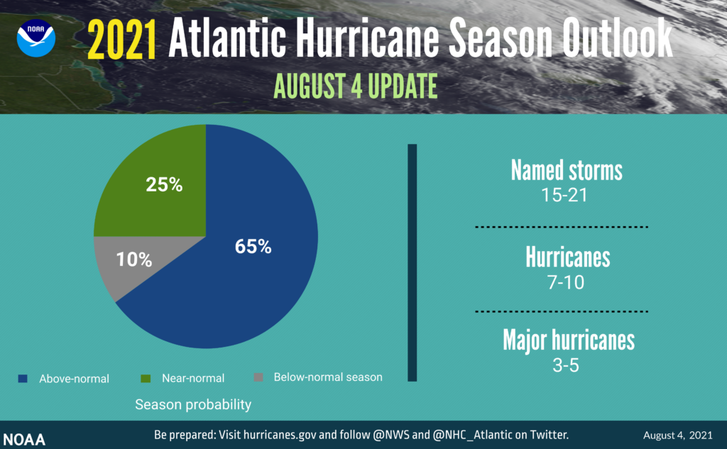
This “increase” simply reflects the fact that the early season was a little more active than anticipated, and that overall nothing has changed with regard to tropical activity for the remainder of the 2021 Atlantic hurricane season. Frankly, we already knew this was going to be an active season. And as Matt wrote on Tuesday, the tropics are now heating up on schedule, with the next six to eight weeks are the time of greatest concern for Texas. Fortunately, there are no immediate threats to the Gulf of Mexico and we’ll continue to take it day by day.
Thursday
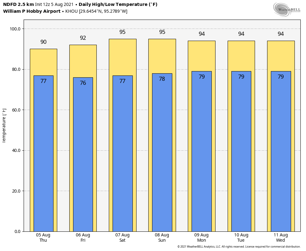
A cluster of showers near Galveston Island is likely to remain confined near the coast this morning, as drier air remains aloft further inland. As high pressure over our region slides east of the region later today, we could see the development of scattered showers this afternoon, generally along and to the west of Interstate 45, but we don’t anticipate anything too organized. Skies will otherwise be partly to even mostly cloudy today, suppressing highs into the lower 90s. Rain chances should end overnight, with lows generally dropping into the upper 70s.
Friday
As the onshore flow begins to return on Friday there may be enough moisture to produce rain across about 30 to 40 percent of the area, but for the most part these should be short lived, light showers. Skies otherwise should be partly to mostly sunny, with highs in the low- to mid-90s.
Saturday and Sunday
Rain chances fall back to around 20 percent over the weekend, or less, as fairly typical August weather moves into the area. We can probably expect highs in the mid-90s with lots of sunshine, so plan your outdoor activities accordingly.
Next week
The forecast for next week looks fairly uneventful. We can probably expect days with highs in the low- to mid-90s, with spotty afternoon showers driven by the sea-breeze. Honestly, any time we’re not experiencing weather that’s extreme in August, I count it as a win.
I love you guys!!!
I really like and appreciate your honest, common sense way of reporting on the weather. I’m worn out with the hysterical and many times dishonest way of reporting weather that we see on many channels. Thank you so much. Yours is our go to weather forecast.
Uneventful has always been my favorite kind of weather!
…Leave it to the media to try and create fear out of basically nothing (that never happens….right?!?!).
Thanks for the honest reporting and accurate portrayal of forecasts – you guys are the best!
Please include wind speeds in your forcast. 101 degrees with 10 mph wind is better than 98 with no air movement. To those of us working outside there’s a big difference.