Heavy rain potential lingers into Saturday for the Houston region

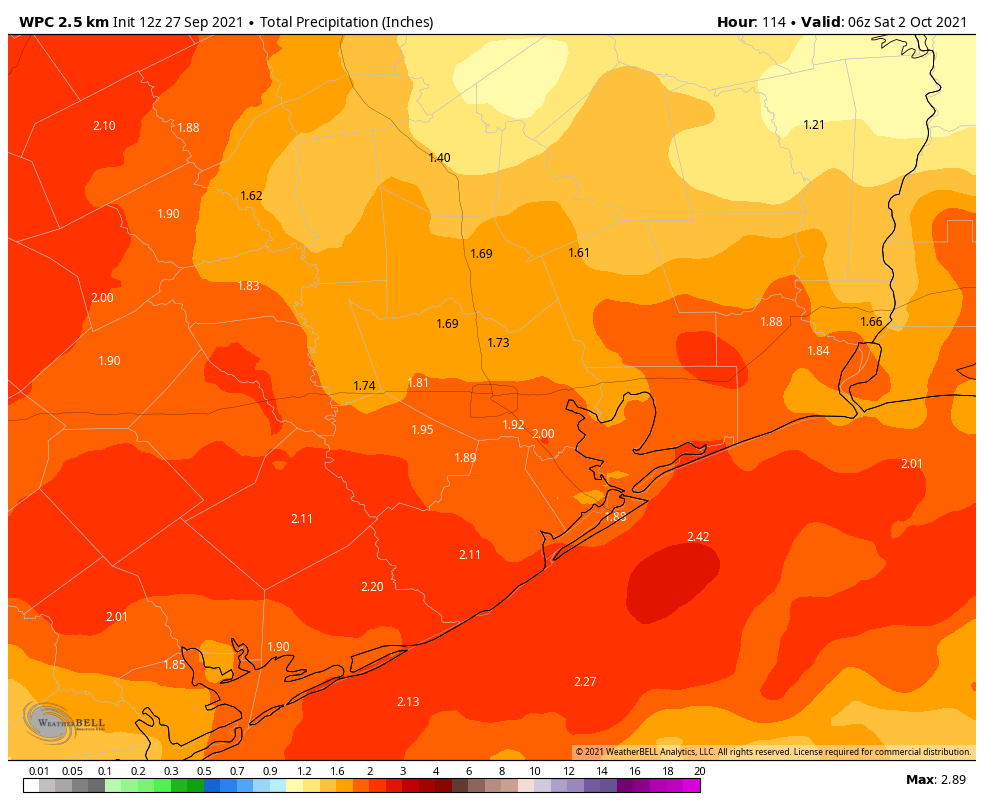
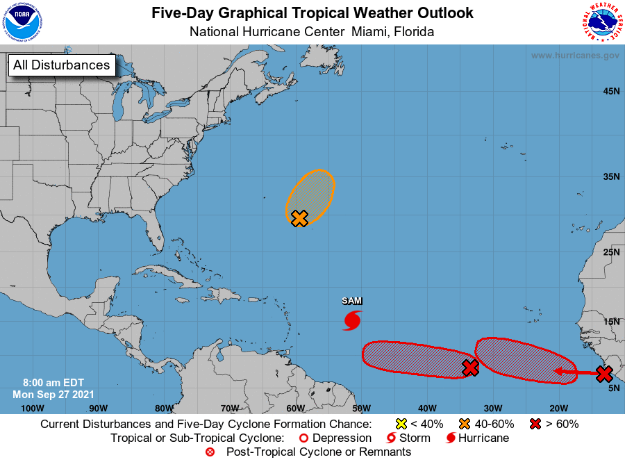
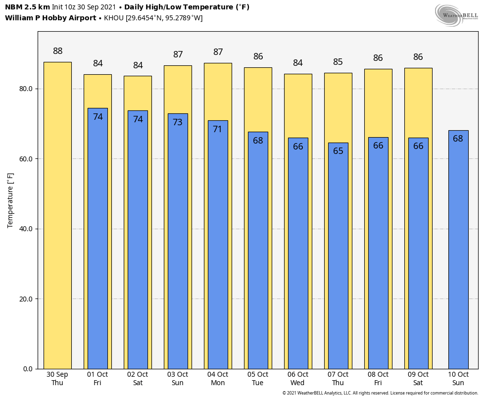
Good morning. Houston faces a couple of more wet days, with the potential for heavy rainfall, before drier and slightly cooler weather arrives early next week.

Thursday

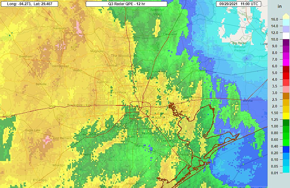
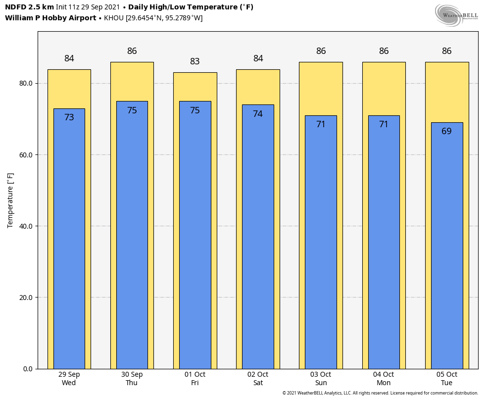
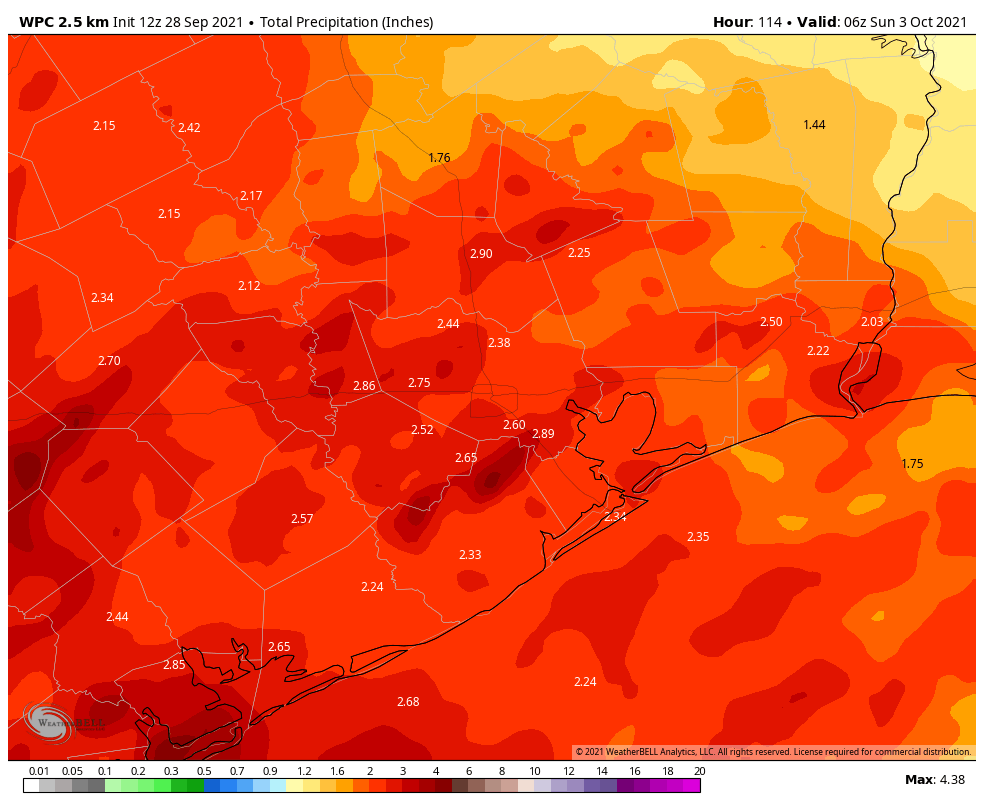
After a quiet night, in terms of rainfall, we’ll see activity increase this morning along the coast and migrate inland during the day. These storms should move along at a decent clip, so we don’t expect major impacts, but some locations could pick up a quick half inch of rainfall. Rain chances are probably greater than 50 percent south of Interstate 10, and less than that for inland areas. With mostly cloudy skies, high temperatures likely will remain confined to the mid-80s for much of the area. Rain chances should slacken late this afternoon, or during the evening.

Friday

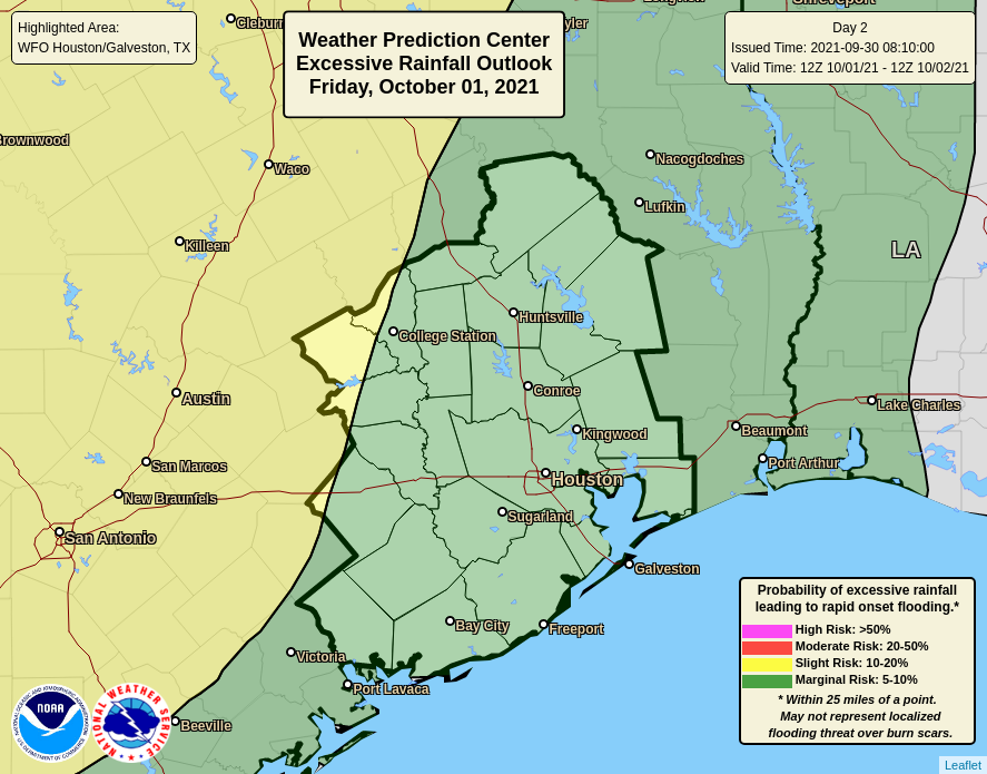
This should be a similar day, as our atmosphere remains moist and open to upper-level disturbances moving through. Rain chances are probably 60 to 70 percent during the daytime, with briefly heavy rain and thunderstorms possible. While there is the potential for heavy rainfall on Friday, conditions are more favorable for this to happen closer to Austin than Houston. Storms should weaken during the late afternoon hours, and likely wind down after sunset. Highs will again be in the mid-80s.

Heavy rainfall risk for Friday and Friday night. (NOAA)

Saturday

The first half of the weekend is far enough out that I don’t feel too confident in the specifics, but with elevated moisture levels it does seem possible that we could continue to see the potential for widespread showers, and some heavy rainfall on Saturday—maybe during the morning hours? The bottom line, I think, is that any outdoor plans on Saturday should come with an asterisk. Highs will probably reach the mid-80s with more cloudy skies.

Sunday

The pattern begins to change on Sunday, with atmospheric moisture levels dropping in advance of a frontal passage. As a result, skies should turn partly sunny on Sunday, with rain chances falling during the day. Highs will be in the mid- to upper-80s. The front itself, which is fairly weak, should push into Houston during the late evening hours or so, and move off the coast over night or early on Monday.

Drier days and cooler nights are in the cards for next week. (Weather Bell)

Next week

Next week should be sunny, in the wake of the front, with highs in the 80s and lows in the 60s. The cooldown won’t be too dramatic, but rain will go away for several days, and the air will be noticeably drier. I’ll take it.

Overnight storms should calm things down a bit for Wednesday

A fairly robust line of thunderstorms rumbled through Houston during the wee hours this morning. Several locations recorded wind gusts in excess of 40 mph, but power outages were fairly scattered with only about 20,000 customers affected in the metro area as of sunrise.

The storms generally brought 1 to 2 inches of rainfall, and this was manageable by the area’s flood system. Transtar is reporting no major flood-related issues on area roadways. We’ll see continued rain chances into the weekend, but this morning’s action was probably the most significant we’re going to see for awhile.

Radar estimated rain totals from 6pm CT Tuesday to 6am CT Wednesday. (NOAA)

Wednesday

The squall line with the strongest storms has moved well east of the Houston region, but light showers will likely continue into mid-morning for much of the area. By or before noon, even this light rain should end and we should start to see some partly sunny skies. As a result, high temperatures should push into the upper 80s away from the coast. A few scattered showers will be possible later this evening or during the overnight hours, but for the most part things should be a lot quieter than Tuesday night. Lows will be sticky, likely only falling into the mid-70s.

Thursday

This should be another day with a mix of clouds and sunshine, and temperatures in the mid- to upper-80s. Rain chances are probably about 50 percent, but we shouldn’t see any kind of organized storms like we saw Tuesday night into Wednesday morning.

Friday and Saturday

Healthy rain chances will continue on Friday and Saturday, with both days likely seeing partly to mostly cloudy skies. It’s certainly not going to be wall-to-wall rain, but there should be enough activity that you’ll want to have a contingency plan for any outdoor activities. Highs both days will probably be in the mid-80s. I would guess that most areas see an additional 1 inch of rainfall, or less, from Wednesday afternoon through Saturday.

The front’s effects are expected to be subtle early next week. (Weather Bell)

Sunday and beyond

Will it or won’t it? That’s the question with a cold front approaching our region by Sunday, and possibly pushing through Houston and off the coast. I think there will be enough dry air moving into our region that Sunday should be partly sunny, with diminished rain chances. Temperatures should therefore be a bit cooler to start next week, with models now indicating that a second push of colder air could arrive by mid-week. By Wednesday or Thursday, then, it probably will start to feel more fall-like.

Widespread showers expected today, and for the remainder of the work week

Beginning this morning, Houston has entered a distinctly wetter pattern that should bring 2 to 4 inches of rainfall to much of the region, with higher isolated totals. While area soils are plenty dry and able to handle such rain, the potential for briefly heavy rainfall could lead to a few flooded streets in low-lying areas at some point this week. The wet period may continue into Saturday morning.

It’s a particularly muggy morning, with highs about 5 to 15 degrees warmer than on Monday. (Weather Bell)

Tuesday

So what has changed? After high pressure moved away from the region, much richer moisture has pushed into Texas from the Gulf of Mexico. Additionally, the atmosphere is becoming more unstable as small disturbances begin to move overhead, promoting rising air. As a result of all this we’re going to see fairly widespread showers today across much of the region. With mostly cloudy skies, high temperatures should reach the mid- to upper-80s to go along with light, southeasterly winds. Rain chances become lower by around sunset, but may begin to increase again during the wee hours of Wednesday.

Wednesday

This will be another day with fairly widespread rain showers—about a 60 percent chance—and mostly cloudy skies. Look for highs in the mid-80s. The evening should again provide a bit of a reprieve from shower activity.

Thursday and Friday

At this point it looks like rain chances will peak on Thursday and Friday, with 70 or 80 percent of the area seeing rainfall each day. Highs, accordingly, will be in the mid-80s without much of a cooldown over night.

NOAA rain accumulation forecast for now through Saturday. (Weather Bell)

Saturday, Sunday, and beyond

Beginning on Saturday skies may turn a little more sunny, but we’ll still have a chance for at least some scattered showers. Sunday should be at least partly sunny as well, with highs nudging back into the upper 80s. After that time we’ll be watching to see if a cold front moving down through Texas makes it all the way through Houston and off the coast early next week . Either way, right now, the front looks to be a fairly weak one, with only moderate effects on temperatures and dewpoints. Your sweaters are safe in their closets, for now.

After sunny days, clouds return with high rain chances later this week

After five sunny and splendid days, Houston’s weather will turn warmer and muggier in the days ahead, with increasing rain chances by Tuesday running through the end of the week. Much of the area should see 1 to 3 inches of rainfall this week, which is fine as it has now been nearly two weeks since Hurricane Nicholas made landfall.

Monday

Today will be somewhat of a transition day after high pressure has departed the region. Yes, atmospheric moisture is returning, but levels should not be high enough to generate much in the way of shower activity. Area-wide, rain chances will be only about 10 percent. There should be enough afternoon sunshine to allow temperatures to approach 90 degrees for much of the region, and lows will only drop into the mid-70s.

Tuesday

Conditions turn more favorable for showers on Tuesday, with rain chances increasing to about 40 percent. Additional cloud cover should shave a degree or two off peak temperatures during the afternoon. Storms will be scattered, and should move fairly quickly from south to north.

NOAA rain accumulation forecast for now through Friday. (Weather Bell)

Wednesday and Thursday

Rain chances will peak on these days, as an energetic atmospheric feature known as a “jet streak” moves overhead and helps air at the surface to rise. As a result, both of these days should be mostly cloudy, with on and off shower activity. Highs will be in the mid- to upper 80s. Rain will be possible during the overnight hours as well.

Friday

Models suggest rain chances will start to diminish on Friday, perhaps to around 50 percent, but this should still be a mostly cloudy day, with highs slotting somewhere in the mid-80s.

Saturday, Sunday, and beyond

The forecast for next weekend remains fairly fuzzy. It now seems unlikely that a front will make it through the area, but we may fall further under the influence of high pressure by Saturday or so, and this should bring sunnier weather back to the region. For now, I’d predict partly sunny skies this weekend, with highs in the upper 80s. But the forecast is written in pencil, rather than pen. The arrival of our next front now looks to be delayed until Tuesday or Wednesday of next week.

Tropical outlook for Monday morning. (National Hurricane Center)

Tropics

The Atlantic tropics remain active, with major hurricane Sam and a couple of more areas likely to develop later this week. However, Sam will probably steer east of Bermuda and avoid any landmasses, and there is no reason to believe any of the other storms in the Atlantic will track far enough west to reach the Gulf of Mexico.