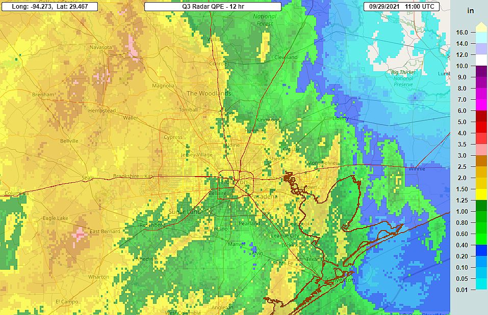
A fairly robust line of thunderstorms rumbled through Houston during the wee hours this morning. Several locations recorded wind gusts in excess of 40 mph, but power outages were fairly scattered with only about 20,000 customers affected in the metro area as of sunrise.
The storms generally brought 1 to 2 inches of rainfall, and this was manageable by the area’s flood system. Transtar is reporting no major flood-related issues on area roadways. We’ll see continued rain chances into the weekend, but this morning’s action was probably the most significant we’re going to see for awhile.
Wednesday
The squall line with the strongest storms has moved well east of the Houston region, but light showers will likely continue into mid-morning for much of the area. By or before noon, even this light rain should end and we should start to see some partly sunny skies. As a result, high temperatures should push into the upper 80s away from the coast. A few scattered showers will be possible later this evening or during the overnight hours, but for the most part things should be a lot quieter than Tuesday night. Lows will be sticky, likely only falling into the mid-70s.
Thursday
This should be another day with a mix of clouds and sunshine, and temperatures in the mid- to upper-80s. Rain chances are probably about 50 percent, but we shouldn’t see any kind of organized storms like we saw Tuesday night into Wednesday morning.
Friday and Saturday
Healthy rain chances will continue on Friday and Saturday, with both days likely seeing partly to mostly cloudy skies. It’s certainly not going to be wall-to-wall rain, but there should be enough activity that you’ll want to have a contingency plan for any outdoor activities. Highs both days will probably be in the mid-80s. I would guess that most areas see an additional 1 inch of rainfall, or less, from Wednesday afternoon through Saturday.
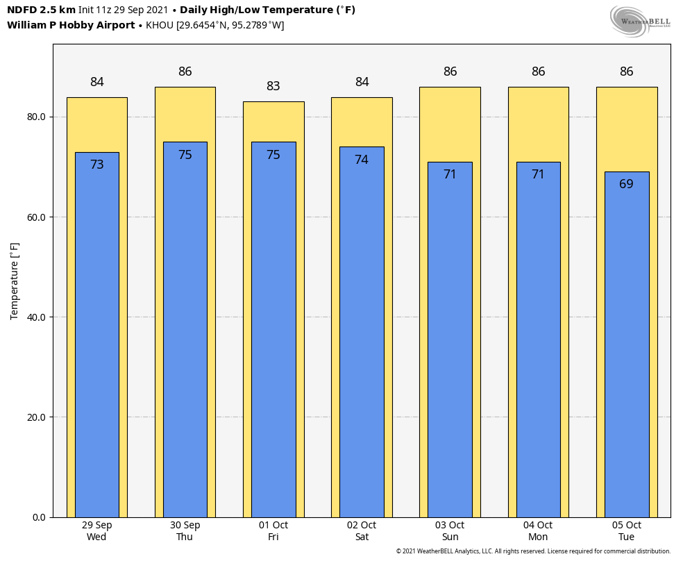
Sunday and beyond
Will it or won’t it? That’s the question with a cold front approaching our region by Sunday, and possibly pushing through Houston and off the coast. I think there will be enough dry air moving into our region that Sunday should be partly sunny, with diminished rain chances. Temperatures should therefore be a bit cooler to start next week, with models now indicating that a second push of colder air could arrive by mid-week. By Wednesday or Thursday, then, it probably will start to feel more fall-like.
Nicholas flashbacks overnight/early morning as I was awoken to loud pounding rain and wind.
You are a great weather forecaster. Thank you for giving us an updated more accurate picture than we know who. 🤗
It’s a little thing, I know, but when we talk about “customers” without power is that “meters”? Because a meter could be four or five people (or a business that isn’t open yet). It’s not on you, but is on CP to help us better define these outages. And, again, it’s weather and I think CP has performed admirably during Nicholas and the occasional high wind/rain event.
Customer=meter.
As Mark H observed, CP generally does a credible job. However, given the frequency with which the area expedience wide spread power outages due to lines down, would it not be reasonable for them to pursue more underground lines rather than overhead power poles. While there would be expenses up front to convert to underground lines, over the long haul there would seem to be less cost with no pole replacement or line damage due to weather incidents. Just a thought.
As always, SCW does an awesome job!
Curious that in yesterdays post, you mentioned that Thursday would be “peak” for rain chances. Now that is diminished. What is the reason/mechanism that this changed so aburptly?
Keep up the great work,thank y’all
My office in Freeport has been flooded since Monday. Roof issues. I understand we are in Groundhog Day until Saturday. Wondering why only one report today.