After a messy front, Houston looks set for another splendid fall weekend

Good morning. The overall forecast remains on track with a front moving in Wednesday night and cooler weather beyond. After a messy period of widespread rainfall, the weekend outlook once again looks absolutely gorgeous.

Tuesday

Patchy fog has formed across the area, as temperatures in some locations have dropped to dewpoint temperatures. This should burn off in fairly short order as air temperatures rise, with mostly sunny skies this afternoon and highs near 80 degrees. Tonight will be mild, with partly cloudy skies and lows dropping to around 60 degrees in the city of Houston, with slightly cooler conditions inland and warmer along the coast. This will be the warmest night of the week, with light southeasterly winds.

Wednesday

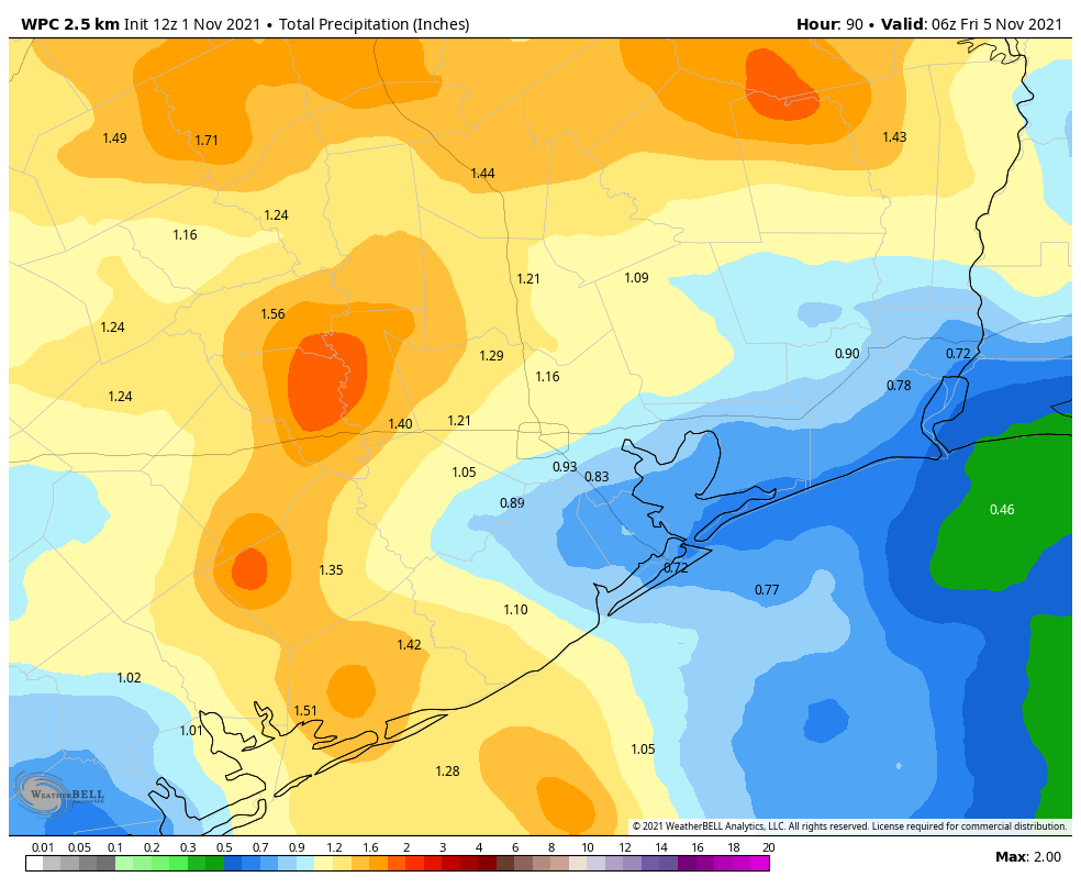
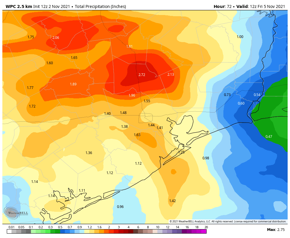
Clouds will start to form ahead of the front, so this should help to moderate highs a bit on Wednesday, perhaps to the upper 70s. It does not appear as though there will be a discrete line of showers with the front, but rather the rains on Wednesday and Wednesday night should be more spread out, and last a little bit longer. Overall, I think most of the area will see 0.5 to 2.5 inches of rain from Wednesday afternoon through early Thursday. (This will be something to keep in mind going to and from the ballpark if there’s a Game 7 of the World Series). The front itself pushes through the region later on Wednesday and early Thursday. Overnight lows should drop into the 50s.

NOAA accumulation forecast for now through Thursday. (Weather Bell)

Thursday

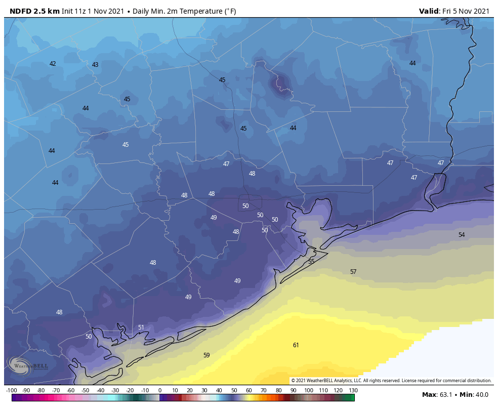
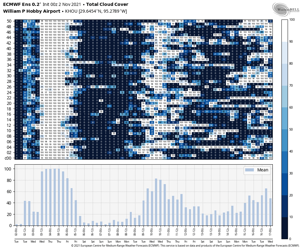
I’m expecting rain showers to end by around sunrise, or perhaps a little later, from northwest to southeast. In the front’s wake we’ll see mostly cloudy skies and cooler weather, with highs likely ranging from the upper 50s north of Houston to mid-60s right along the coast. With moderate northerly winds of 10 to 15 mph, this will be a chilly day. As skies clear later Thursday or overnight, temperatures will drop to around 50 degrees in Houston, with 40s outside of the city.

Friday, Saturday, and Sunday

This will be a splendid stretch of fall-like weather, with sunny skies and cooler weather. Highs will climb from the mid-60s on Friday to lower 70s on Sunday. Overnight lows will remain fairly cool as well, likely in the 50s for most, but colder in outlying areas.

A solid block of sunny skies (darker colors indicate fewer clouds) are pretty much guaranteed from Friday through the weekend. (Weather Bell)

Next week

We’ll see a gradual warm up next week, with highs likely reaching about 80 degrees by Wednesday or Thursday. After that point you can probably pencil in another front ahead of next weekend. Dare we dream of three lovely fall weekends in a row? Yes, we can dream of such.

Houston will fall more deeply into fall this week—we’re talking real sweater weather

Houston has enjoyed a handful of cold fronts so far this fall, but after a few days we’ve always warmed back up into the upper 80s or low 90s. But this week, after a stunning weekend, we’ll barely warm up to 80 degrees before a strong front arrives on Wednesday. And after that front we’ll be in the 60s and 70s for awhile.

I also wanted to spare a few words for the Houston Astros, who found themselves in a challenging spot after a grand slam in the first inning on Sunday night. And still, they battled back, clawing even with the Braves, and then ultimately winning. Now the hometown team returns to Houston for two more games, needing to win both. Minute Maid Park has a roof, so weather won’t be a concern on the field. However it’s possible that the timing of the next front coincides with the aftermath of Game 7 on Wednesday, assuming there’s a Game 7. (And we are). More on this below.

Monday

Today will bring more great weather to Houston. Highs will get into the upper 70s to 80 degrees, with mostly sunny skies. Dewpoints will creep up, so conditions will feel a bit more humid than we experienced over the weekend, but the air won’t be uncomfortable by any means. Winds will be light, generally out of the southeast. Overnight lows tonight will generally fall to around 60 degrees in the city, with slightly cooler conditions for outlying areas, and warmer along the coast.

Tuesday

Some patchy fog will be possible on Tuesday morning, but that should burn off rather quickly, leaving us with another mostly sunny day and highs near 80 degrees. Overnight lows will again fall about 60 in Houston.

NOAA rainfall forecast for now through Thursday. (Weather Bell)

Wednesday

We’ll start to see some cloud cover on Wednesday, and with the onshore flow this day will feel a little bit more humid with highs likely ranging from 75 to 80 degrees. The front’s timing remains somewhat uncertain, but I’d expect it to come through some time between Wednesday evening or early Thursday morning. We probably will see some briefly moderate to heavy rain with the front—hence my concern about the aftermath of a potential Game 7—but I’m not sure exactly when this is coming. Most areas probably will receive about 1 inch of rain with the front. Hopefully we’ll be able to firm up the front’s timing in tomorrow’s post.

Thursday

Today’s a sweater day! Clouds should persist for much of Thursday, and this will help to confine high temperatures into the low to mid-60s for the city, with possibly the 50s for inland areas. With moderate northerly winds (nothing like last week), this will be a chilly day and lows Thursday night may drop into the 40s for all areas but the coast.

Friday morning’s lows may end up being a few degrees cooler than this forecast, even. (Weather Bell)

Friday

Friday should start out clear and cold, and despite sunny skies I’d expect highs to only reach the mid-60s. Winds should be fairly light out of the north. Expect another chilly night, with much of the area reaching the 40s.

Saturday, Sunday, and beyond

The weekend looks amazing, with highs of around 70 degrees and lots of sunshine. Rain chances are bascially zero. Plan your outdoor activities with confidence. The early part of next week should bring highs in the 70s with partly to mostly sunny skies and nicely dry air.