Summer lite settles in over Houston this weekend

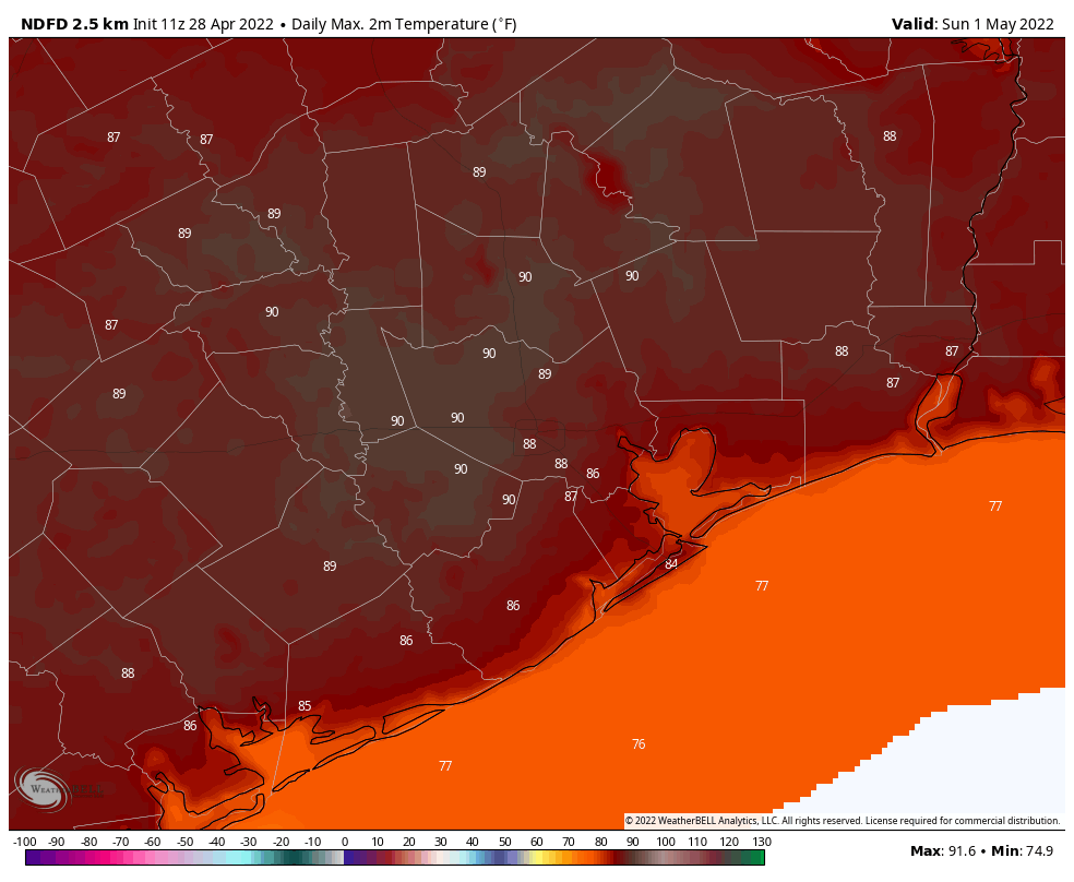
As we prepare to flip the calendar to May, the weather will fast forward a few weeks, as forecast highs near 90 degrees, more commonplace for late May, become a feature in the days ahead.

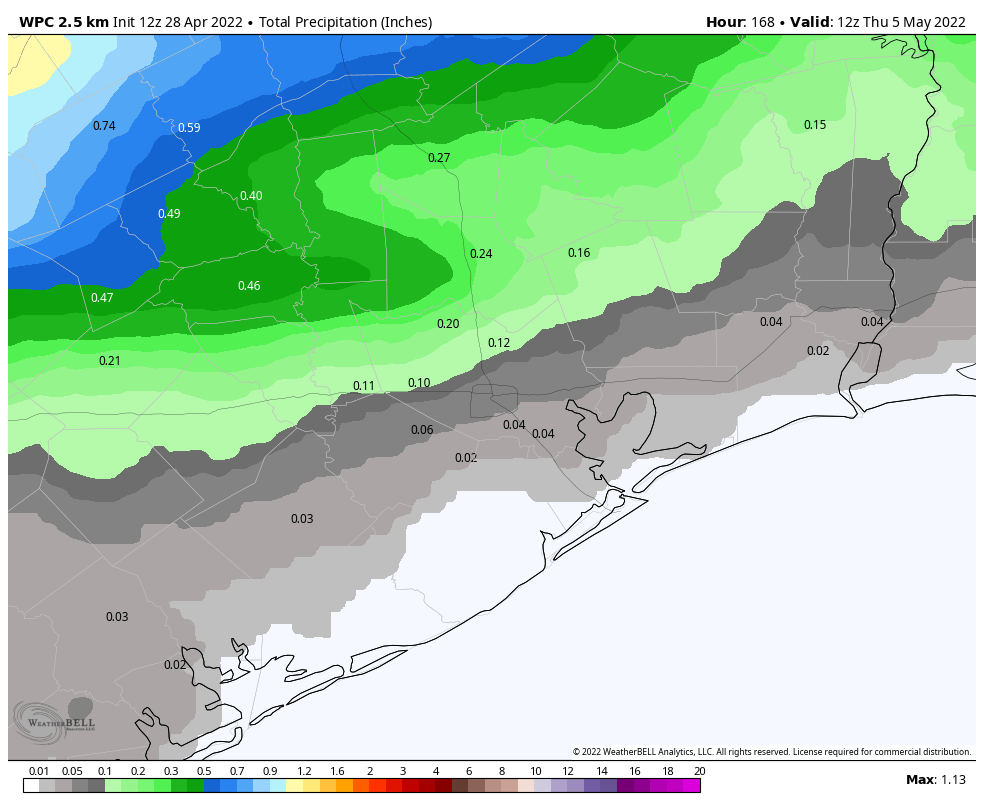
We’ll start today with a drought update. You probably assumed that this week’s impressive rains acted to relieve the drought some in our area, and you would be correct. Coverage of drought in the Houston area dropped about 15 percent versus a week ago. We’ll need another couple rounds of storms in the next couple weeks to keep that improvement going.

Drought coverage remains widespread south of I-10, but it has mostly disappeared for now north of I-10. (US Drought Monitor)

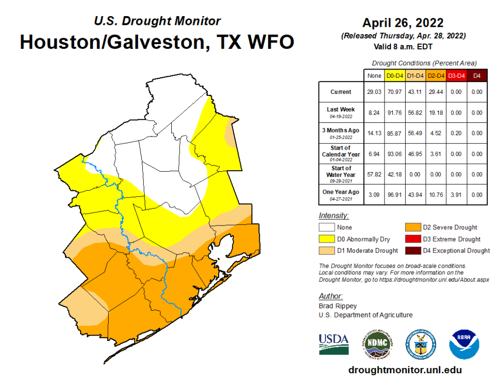
Will we get that? I’m not sure, truthfully. The pattern will support active weather near our region, but it may miss us to the north and east more often than not, so we’ll have to see. This could be a situation where things don’t change much north of Houston but perhaps they get worse south of Houston. That brings us to the forecast.

Today

Sun and clouds will mix for us today, and we’ll see temperatures and humidity both nudge higher versus yesterday. We should do mid to upper-80s for highs this afternoon.

Weekend

This weekend will see a cold front drop south into the extreme northern fringe of our region tomorrow. We expect it will stall out north of Huntsville, but it may come close enough to deliver at least a few showers into the northern third of the Houston area tomorrow afternoon. The best chance would be outside the Beltway to the north; think Conroe, Cleveland, Magnolia.

An additional slight chance of showers would be in play on Sunday as well, again mostly north or perhaps east of the area. We don’t believe you’ll need to alter any weekend plans, but just be prepared in case a stray shower or downpour passes by.

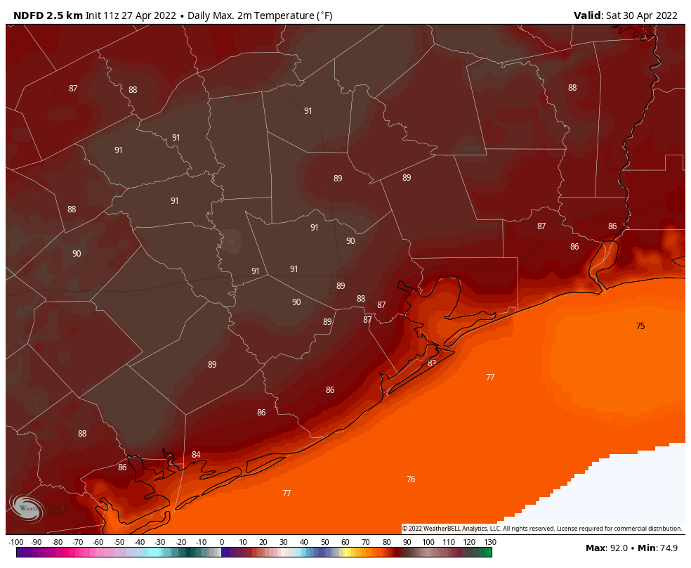
It will be firmly like mid-May this weekend with lows in the 70s and highs in the mid to upper-80s.

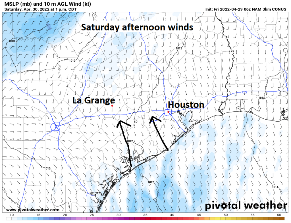
For those of you riding in the MS 150 this weekend, day 1 will feature those hot temperatures but also a south wind. It will be consistent along the length of the ride from Houston through La Grange, sustained around 5 to 10 mph, with periodic gusts closer to 20 mph.

Saturday’s leg of the MS 150 will feature south or south-southeasterly winds at 5 to 10 mph with higher gusts at times. (Pivotal Weather)

Day 2 will be a little breezier. While temperatures and humidity should be about on par with Saturday, the wind will shift to more of a southeasterly breeze. It will be more like 10 to 15 mph, with more frequent 20 mph gusts.

The second leg of the MS 150 will be breezier with southeast winds of 10 to 15 mph, gusting to 20 mph or a bit stronger at times.

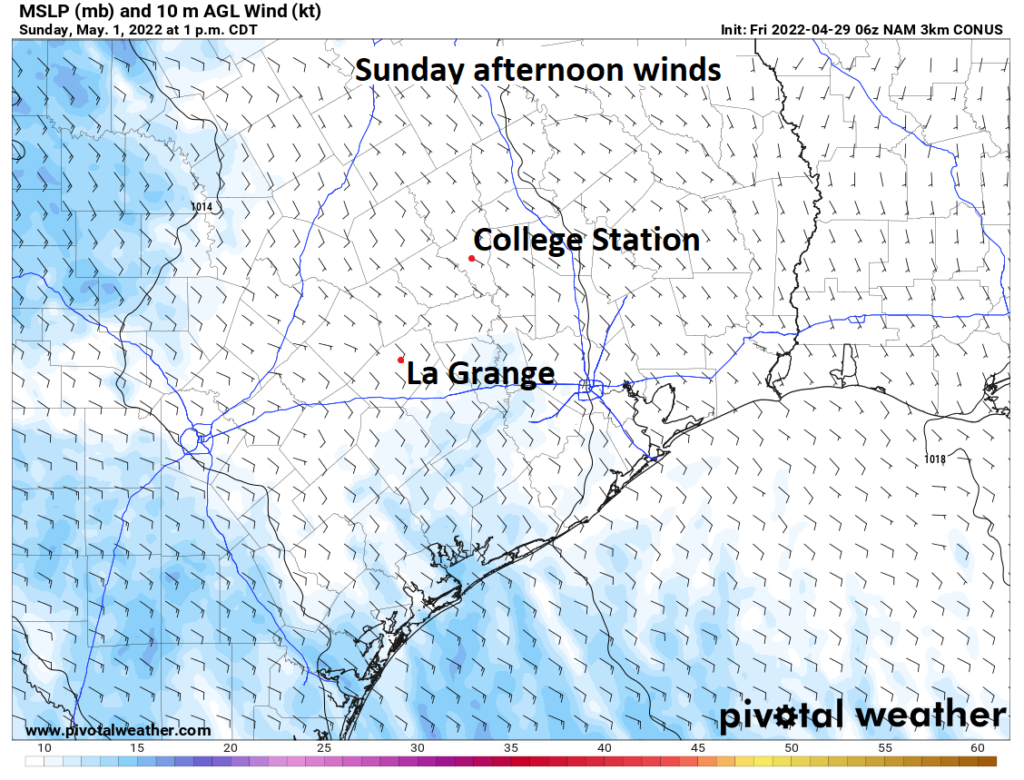
It should never be a headwind, but it may be a bit annoying at times. Keep an eye out for a few showers, especially on day 2, but it should hopefully be nothing that causes any problems. Whatever the case, good luck to all those participating!

Early next week

The first part of next week should be fairly similar to the weekend: Clouds, sun, hot temperatures, high humidity, and a very slight chance of a few showers. Expect lows in the 70s and highs well into the 80s, with an outside shot at 90 degrees in spots, along with a noticeable south or southeast wind, gusting to 20 mph or so.

Later next week

The late week question revolves around whether or not we get a cold front into our area. Right now, that seems to be a low probability thought. The front should probably hold out until the weekend, and even if it gets here, any relief would be brief. Outside of that, we will keep hot temperatures, high humidity, and a low-end rain chance each day heading toward next weekend. We’ll refine this more on Monday.

After our spring fling, warmer, more humid weather is on the way

Good morning. After our spectacular weather on Wednesday, the story of the next several days will be that of warming weather to the point where it almost feels like summer in Houston, but not quite. I expect we’ll see several days of low 90s next week.

Thursday

Today will bring something of a transition day, as southerly winds start to pick up to around 10 to 15 mph. This increase in atmospheric moisture will help generate a few clouds and nudge high temperatures into the low- to mid-80s. We’ll also see dewpoints rise into the mid-60s, which will start to bring more humidity in, but won’t feel oppressively so. Overnight low temperatures on Thursday likely won’t drop much below 70 degrees for most of the area.

Friday

By Friday we’ll be well into the upper 80s, with southerly winds gusting to about 20 mph, and a mixture of sunshine and clouds. Lows Friday night probably will drop to only about 70 degrees.

By Sunday much of the region will likely see highs of 90 degrees. (Weather Bell)

Saturday

The first half of the weekend will see a cold front push into Texas, but probably not into the Houston metro area. In response to the approaching front our winds from the south may veer a bit more southwesterly, and this is likely to boost temperatures. I expect much of the region away from the coast to reach 90 degrees. For areas north of Interstate 10 there is perhaps a 10 or 15 percent chance of rain later on Saturday or Saturday night.

Sunday

Sunday should bring more of the same, with partly sunny skies and highs near or at 90 degrees. There will again be a slight chance of rain but the vast majority of us will remain dry. Southerly winds, at times gusting to 15 or 20 mph, should be a constant companion. With dewpoints rising into the low 70s, expect it to feel sticky outside for sure.

NOAA rain accumulation forecast for now through next Wednesday. There won’t be much. (Weather Bell)

Next week

High pressure will begin building over the weekend, and we’ll feel its effects at least through the middle of next week and possibly beyond. This will manifest itself in highs near 90 degrees, or just above, with partly sunny days and warm, humid nights. When might this change? Maybe next weekend, around Friday or Saturday, or thereafter, some kind of weak front might make it through. No promises whatsoever, I’m afraid. Fall, winter, and spring have had a good run … but now we’ve got to face up to about five months of summer.

Today’s the day, y’all. I’m not guaranteeing this will be the last day of “spring,” but it might well be

Good morning. Houston will enjoy a spectacular spring-like day today before we start our rise toward weather I like to call “summer lite.” While the next 10 days won’t feel like the truly sultry conditions we get here in August, after winter and spring the near-90 degree weather with ample humidity won’t feel far off. Bottom line: Enjoy the dry air today, because it will be gone tomorrow.

Also, I want to announce that I’ve started a Space City Weather TikTok page. For many of you, this will be an announcement of no consequence. But my 14-year-old daughter convinced me to experiment with it, so that’s what I’ll be doing. It will be a mix of weather, nerdy humor, and no doubt for me, a modicum of embarrassment.

Temperatures just before sunrise on Wednesday morning. (Weather Bell)

Wednesday

Today’s the day, folks. We may see one or two more weak fronts this spring in Houston, but looking out over the next 10 days there are absolutely no guarantees of that. So enjoy today if you can. We’ll see reasonably dry air—with dewpoints in the 50s—and sunny skies as highs climb to around 80 degrees. Winds will be out of the east at 10 to 15 mph. Temperatures tonight will only be a few degrees warmer than Tuesday night, but the air will already start to feel a bit more humid.

Thursday

This is kind of a transition day from spring to summer lite, as we’ll only probably see temperatures in the low 80s. But there will be some clouds, and we will start to see some gusty southerly winds at 20 to 25 mph. Lows Thursday night may not drop below 70 degrees in some parts of Houston.

Friday

Expect partly sunny skies, with highs in the upper 80s and more southerly breezes, perhaps gusting to 25 or even 30 mph.

By Saturday, temperatures will be pushing 90 degrees in our region.

Saturday and Sunday

You guessed it: More heat and humidity. Highs this weekend will push the upper 80s to possibly 90 degrees, with a mix of sunshine and clouds. We can’t rule out a few scattered showers on each afternoon, but the chance is only probably 10 or 15 percent each day. Expect ongoing southerly breezes. If you’re riding in the Bike MS: Texas MS 150, be sure and drink plenty of water.

Next week

Not a whole lot changes to start next week, with daily rain chances of 10 to 20 percent. However it looks like, by the middle of next week, high pressure may start to exert more influence. That would shut down any potential for rain, and drive highs into the low 90s. So, yeah.

Enjoy two drier days before humidity and heat return

The Houston region received some much needed rainfall on Monday. The 0.25 to 3 inches of rainfall picked up will not erase our emerging drought, especially for areas south of Interstate 10, but for many parts of the area this was the first meaningful rainfall in all of April. Our next decent chance of rain will come next Sunday or Monday, but it is by no means a slam dunk.

Radar-estimated rainfall totals for Monday and Monday night in the Houston region. (NOAA)

Tuesday

The rains have ended for now, and northerly winds are bringing drier air into the region. Highs today will probably reach about 80 degrees beneath partially clearing skies this afternoon, as winds continue at 10 to 15 mph from the north. This evening should be quite pleasant, as winds relax and we see some of the last dry air of this spring. Overnight low temperatures will drop into the 50s for areas well inland, with 60s closer to the coast.

Lows on Wednesday morning will be reasonably chilly for late April. (Weather Bell)

Wednesday

This should be a great day, with highs of around 80 degrees, sunny skies, dry air, and light winds. Really, if you can spend a little time out doors morning, midday, or evening, you should.

Thursday and Friday

As the southerly flow reestablishes itself, our humidity and temperatures are going to go up. These will be partly sunny days with highs in the low to mid-80s on Thursday, and mid- to upper-80s on Friday. Nighttime lows will bounce back up to the low 70s.

Saturday, Sunday, and beyond

Saturday will almost feel summer-like, as temperatures reach near 90 degrees, with lots of sunshine and plenty of humidity. Sunday may see a few more clouds, and there probably will be a 20 percent chance of rain, or so, as the atmosphere is perturbed by an advancing cold front that will wash out well north of Houston. Some modest rain chances will remain for the first part of next week, with daily highs in the upper 80s to 90 degrees.

There is a decent chance of a cool front around the end of the first week of May, perhaps in the Thursday or Friday time frame of next week. But it is far, far from a lock at this point.