Eye on the Tropics: Let’s get this party started

Welcome to our first edition of Eye on the Tropics for the 2022 hurricane season. Each Tuesday, Eric or myself will get you caught up on the big picture in the Atlantic basin. From now into August, it gives us a space to expand on some tropical thoughts a bit more expansively than we can in our morning posts. Usually by mid-August there’s enough happening each day to include in our regular emails. Until that time, though, we’ll cover the bases on Tuesday.

Tropical outlook in a sentence

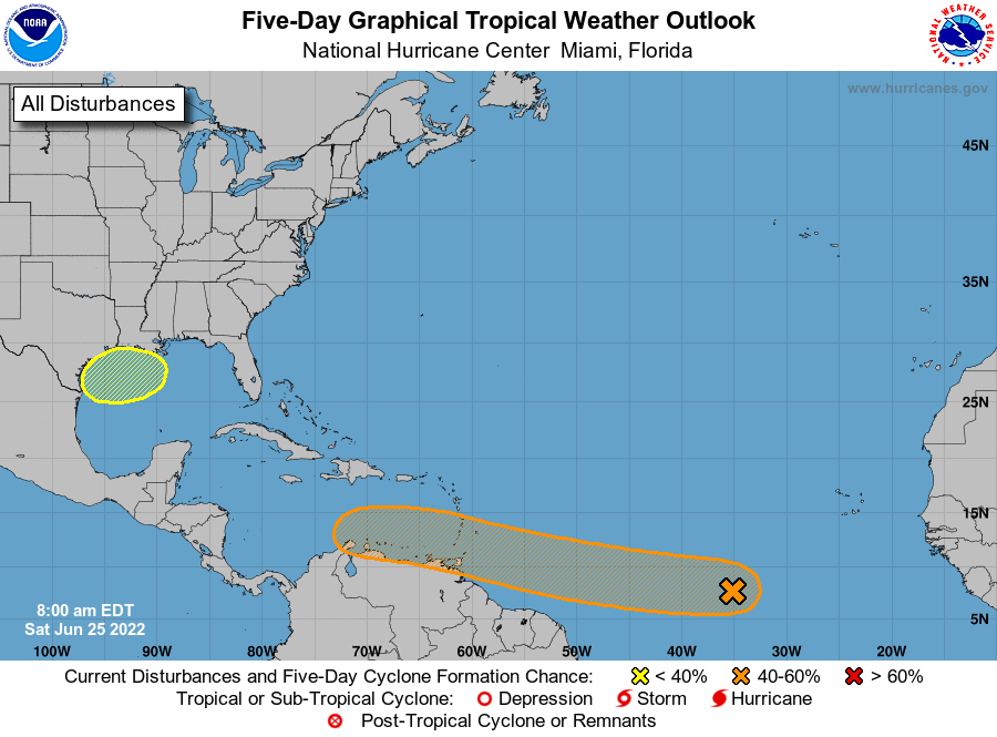
We have a fairly active Atlantic basin, especially for late June, and although no storm is expected to be significant we have something to watch close to home with Invest 95L in the Gulf of Mexico.

2022 to date

Through this morning, we have had one named storm this season. We were up to the “D” storm by this point in the season in both 2021 and 2020. Good omen? Perhaps, but this is really just normal for June. It’s typically not that active of a month. We normally see storm two in mid-July. So instead of being a month or more ahead of schedule this year, we’re only about two or three weeks fast. Progress!

Gulf system (Invest 95L)

Eric had a very thorough and fine write-up on this system and how much rain it could bring to Texas this morning. I won’t reinvent the wheel here, and I encourage you to read his post for the latest.

Potential Tropical Cyclone 2

Elsewhere, we have nothing to worry about in the tropics, but things are active. A common question we get this time of year involves people planning trips to various tropical paradises. They want to know if they have to worry about “that thing out there.” That’s why we’re here!
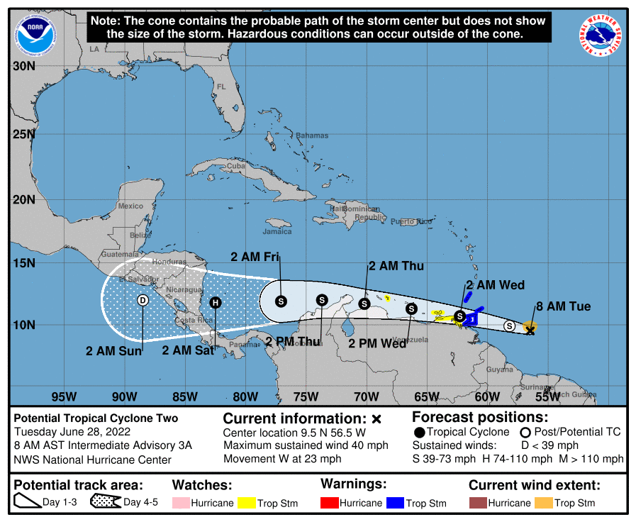
Potential Tropical Cyclone #2 will approach Trinidad later today and it should scrape the coast of Venezuela on its way toward Central America. (NOAA)

Potential Tropical Cyclone Number Two is located just east of Trinidad and Tobago. That’s a mouthful, but in simple language: It’s a system that meets tropical storm criteria (winds of 39 mph or higher) near land, but lacks a defined center just yet. It’s moving steadily westward, potentially on a collision course with <checks notes> Venezuela. Not a lot of history of storms in June and July this far south. In fact, if PTC 2 can develop into an actual tropical storm, it would be one of the farthest south this early on record.
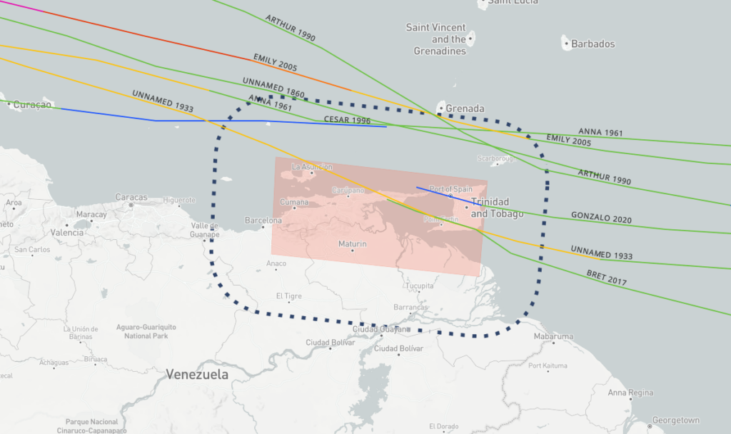
A map of all known June and July storms traveling within 60 nautical miles of where PTC 2 is expected to go near Trinidad and Venezuela later this week. It’s not many. (NOAA)

The good news is that track forecast confidence is very high with this storm now. We have very little serious deviation between models or ensemble members, which gives us good support for a predictable outcome. In this case, it involves PTC 2 hauling due west, with maybe just a slight northward component. But ultimately, it’s likely on a collision course with Nicaragua or perhaps Honduras. As confident as we are on track, the opposite is true about intensity. Given its historically hostile location (the eastern Caribbean), the time of year, its proximity to land, and the fact that it’s moving around 20 mph or faster, there are a lot of extraneous factors that could impact the storm’s intensity negatively. Yes, this has a chance to become a hurricane as it approaches Central America, but it probably has equal chances of not being one too.

If your travels take you to the islands or Mexico, you probably have no issues to worry about. Elsewhere in Central America, it’s worth continuing to watch. The good news is that this thing is moving fast enough that it will probably emerge into the Pacific Ocean fairly quickly. So hopefully that leads to minimal flooding issues in Central America.

To note: The next name on the list after Alex is Bonnie. So if PTC 2 can develop, it will get that name. Sadly, the “C” storm is not Clyde, it’s Colin.

Other Atlantic items

The National Hurricane Center is offering 20 percent odds that another tropical wave can develop in the Atlantic over the next 2 to 5 days.
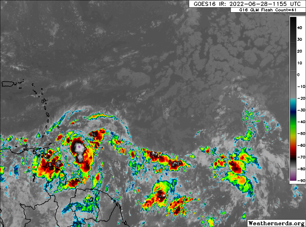
PTC 2 at left and the 20 percent chance wave at right in the Atlantic earlier this morning. (Weathernerds.org)

At this point, model support is pretty mediocre on this one, unlike PTC 2, which had pretty robust model support. So, while we’ll continue to watch this wave, honestly, there’s nothing intelligible we can say about its future at this time. Unlikely to develop, but there’s a small chance. We’ll see where we are next week.

Beyond that, there’s nothing on our radar for the next 10 days or so. Hopefully we can enjoy another July lull this year after a fairly busy start to the month. More next week!

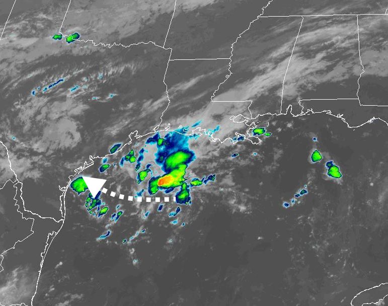
Rain is coming to Houston later this week, but how much?

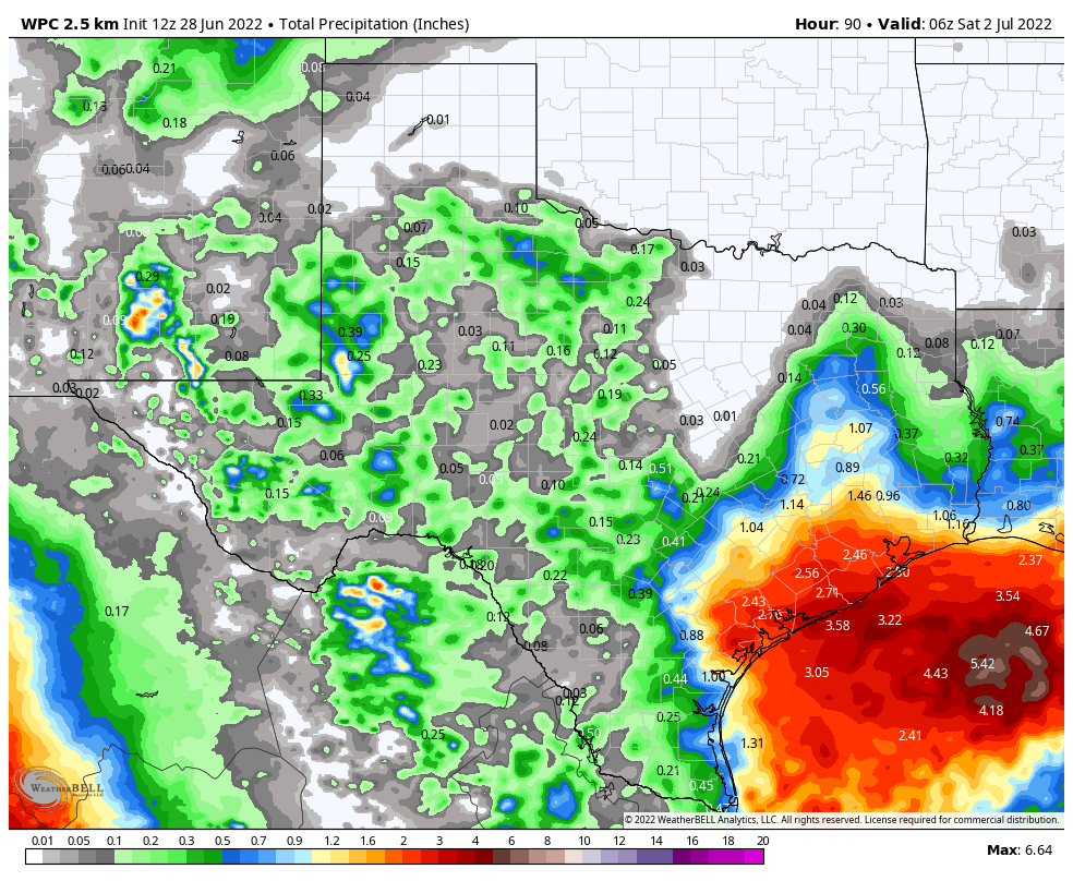
Good morning. Houston remains on track for a decidedly cooler and wetter week, with the major question facing us being how much rain the region will receive. For now, I’d expect most locations in the Houston metro area to pick up 1 to 3 inches between now and Friday. The higher end totals, generally, will come near the coast, with lower-end accumulations for inland areas north of Interstate 10.

But there remains a lot of uncertainty as a broad area of low pressure moves westward across the Gulf of Mexico, toward the Texas coast. Given this, the region could see quite a bit more rain, or rain totals could underperform. If you’re wondering about the holiday weekend, sunnier and hotter weather should return by Saturday or Sunday, ahead of the Fourth of July.

As of Tuesday morning the bulk of the tropical low’s storms are offshore. That will change as it moves closer to Texas this week. (NOAA)

Tuesday

The cool front that moved through on Monday and generated showers and thunderstorms for parts of the metro area has moved offshore, and that’s where the bulk of the rain will fall today. I expect inland rain chances of only about 10 to 20 percent, with slightly higher chances right along the coast. Skies will be partly to mostly cloudy today with highs in the low- to mid-90s, and light northeast winds.

Wednesday

Rain chances start to tick upwards on Tuesday night into Wednesday as the aforementioned low-pressure system in the Gulf of Mexico starts to slowly approach the Texas coast. Still, I’d only peg rain chances at about 50 percent for the coast, with diminishing chances for inland areas on Wednesday. Again, the bulk of the rainfall should remain offshore. Look for high temperatures in the low 90s and mostly cloudy skies, with light northeasterly winds turning easterly.

Thursday and Friday

This is when the potential for heavy rainfall will peak. The key questions are where the tropical low pressure system goes, and whether it gets organized into a tropical depression. The low itself is likely bound for the south or central Texas coast. If it organizes sufficiently, this would tend to bring the heaviest bands of rainfall closer to the center of the storm, and south of Houston. If the low remains disorganized, the potential for heavy rainfall would cover much of the Texas coast, including the Houston metro region. As of this morning, the National Hurricane Center is giving the system a 30 percent chance of developing into a tropical depression or storm. Regardless of what happens, we do expect to see at least some precipitation as the upper Texas coast will fall on the eastern, or “wetter” side of the storm. The question, again, is how much.

NOAA rain accumulation forecast for now through Friday. Subject to significant change. (Weather Bell)

High temperatures will depend on the extent of rain, so look for anything from the mid-80s to 90 degrees on both days, with mostly cloudy skies.

Saturday and Sunday

For now it appears as though the low and its attendant rainfall will be largely gone by the weekend, setting up a pair of partly to mostly sunny days with highs in the low- to mid-90s. I’m not ready to rule out rainfall, given the uncertainty over the next couple of days, but chances are probably in the 20 percent range, especially after Saturday morning.

Next week

By the Fourth of July, on Monday, I am reasonably confident that we’ll see mostly sunny skies and highs in the mid-90s. This is fairly typical weather for early July. Such conditions should prevail for most of next week.

Tropics

Beyond the Gulf of Mexico there is a lot going on in the tropics for late June, but none of this is a direct threat to Texas. Matt will have a full rundown for you in a tropics update later today.

After a month of heat, Houston’s pattern finally turns cooler and wetter this week

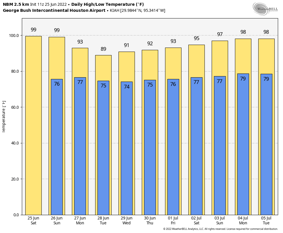
Good morning. Houston has been exceptionally hot and dry—in terms of rainfall, not humidity—for the last four weeks. Our weather has largely been dominated by more or less intense ridges of high pressure. This week there will be two features driving up our rain chances, and bringing temperatures more in line with the “early summer” period.

The first feature is a cool front that will move down to the coast and stall today. Then, by the middle of this week a low pressure system over the gulf of Mexico should approach the Texas coast. This will bring a fair amount of rain to coastal areas of the state, but it remains to be seen whether the bulk of that rainfall drops over the Houston metro area, or further down the coast.

Finally, a quick note to App users: We have fixed a bug that did not display the latest posts. Please download the latest version to fix this, and thank you for your patience.

Rain accumulation forecast for now through Friday. This is definitely subject to change. (NOAA)

Monday

For a change, skies today will be partly to mostly cloudy, and this should hold high temperatures to the mid-90s. The front will bring scattered showers to areas primarily north of Interstate 10 later this morning and during the afternoon, with the focus shifting to the coast this afternoon and evening. Stronger storms, generally, will be more likely near the coast. I think about 40 percent of the area will see rainfall, with a few isolated areas picking up an inch or so, and most of the rest a tenth of an inch or two. Winds will be out of the west this morning, turning to the northeast after the front’s passage. Lows tonight will drop into the mid-70s.

Tuesday

Skies will be partly sunny on Tuesday, with highs likely only reaching about 90 degrees. Rain chances look pretty low for inland areas, but for locations south of Interstate 10 I think there’s perhaps a 20 or 30 percent chance of rain. Light northeast winds will shift to come from the east.

It is possible we’ll see highs in the 80s by Thursday. (Weather Bell)

Wednesday, Thursday, and Friday

As noted in the introduction, our weather during the second half of the work week will largely be determined by the movement and strength of a low-pressure system over the Gulf of Mexico. There remains only a small chance this system, presently south of Louisiana, will develop into a tropical depression, so the primary weather we’re going to see from it is rainfall. At this time Matagorda Bay seems a more likely bet for the heaviest rainfall than Galveston Bay, but this system will be bringing a lot of atmospheric moisture to the coast, so we will see.

What we can say is that Wednesday, Thursday, and Friday all have the potential for moderate to heavy rainfall, and that chances of this are significantly higher if you live near south of Interstate 10, and even better the closer you live to the coast. I’d guess areas south of Interstate 10 end up seeing 1 to 4 inches of rain this week, and areas north 0.5 to 2 inches. However, this is a dynamic situation and forecasts will change. Highs will range from the mid-80s to 90 degrees depending on cloud cover and rainfall.

Saturday, Sunday, and July 4th

The weekend looks warmer and sunnier, with highs perhaps in the low- to-mid-90s and diminishing rain chances. At this point the Fourth of July holiday looks to be hot and mostly sunny, but there are no guarantees this far out.

There’s a lot of action in the tropics for late June. (NOAA)

Tropics

Beyond the weak Gulf system, there are two other tropical waves worth watching. The area in red, Invest 94L, looks to be bound for Central America. The other wave’s track is less certain, but at this time I don’t think it’s a threat to the Gulf of Mexico either. For now, therefore, our focus will remain closer to home.

Low pressure system likely to increase rain chances next week

We’ve been mentioning the possibility of some elevated rain chances beginning on Monday of next week, and now the forecast is coming into slightly better focus.

A surface cold front will move off the northern Gulf coast into the Gulf of Mexico this weekend, and once there it may find favorable conditions for some kind of development. We think it probably will remain a low pressure system, but there is a chance it could become a tropical depression or even less likely, a tropical storm.

The National Hurricane Center gives the Gulf blob a 20 percent chance of becoming a tropical depression or storm.

Given the steering flow at present in the Gulf of Mexico, and retreating high pressure over Texas, this low-pressure system will most likely track westward across the Gulf. This would bring increasing rain chances to the upper Texas coast, including Houston, beginning later on Monday and through Wednesday. I must stress that at this time these rains look nothing but beneficial for our parched region.

Accumulations are nearly impossible to forecast given the uncertainty at this point, but I’d guess most of the Houston region will receive 0.5 to 3 inches of rain, with a greater likelihood of rain near the coast. By Tuesday the increasing cloud cover should also drive daily temperatures back to around 90 degrees for a couple of days. Eventually this system should move west, clearing our area by later on Wednesday or Thursday.

Houston will see two more days of excessive heat before things start to cool off slightly. (Weather Bell)

As ever, tropical systems are dynamic, so we’ll be watching this closely. If the situation changes, we’ll update you on Sunday. If not, look for our regular post on Monday morning.

App note

We’re aware of an issue with the Space City Weather app in which it is not displaying the most current posts on some devices. Our developer has identified the bug and is working to push out an update soon. Please accept our apologies for the issue.