We’ve been mentioning the possibility of some elevated rain chances beginning on Monday of next week, and now the forecast is coming into slightly better focus.
A surface cold front will move off the northern Gulf coast into the Gulf of Mexico this weekend, and once there it may find favorable conditions for some kind of development. We think it probably will remain a low pressure system, but there is a chance it could become a tropical depression or even less likely, a tropical storm.
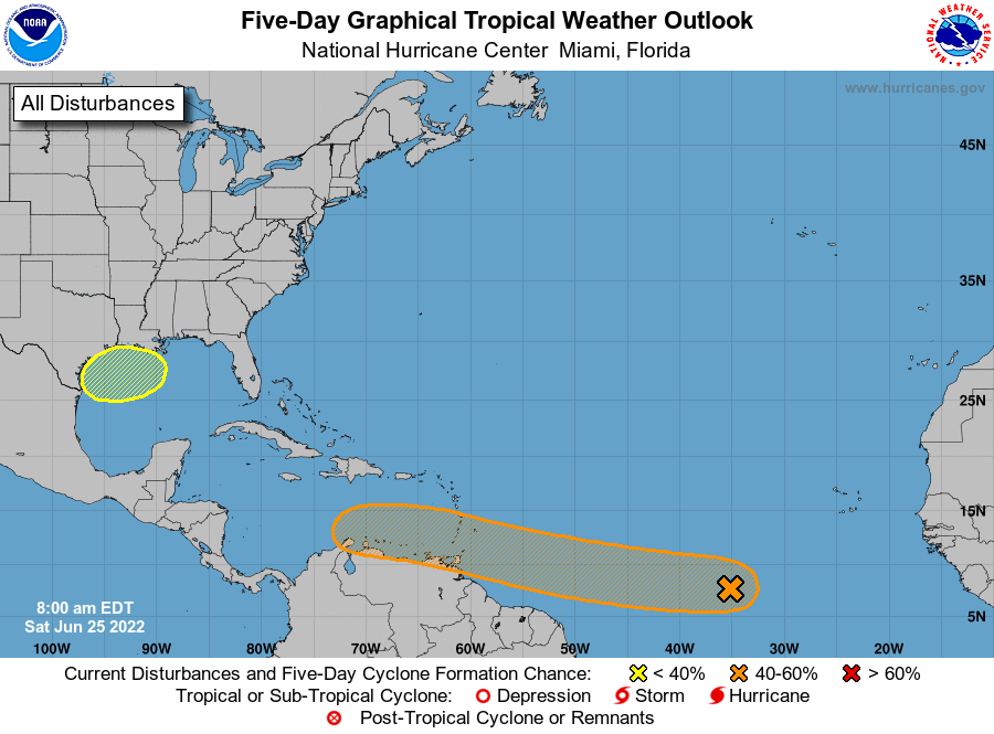
Given the steering flow at present in the Gulf of Mexico, and retreating high pressure over Texas, this low-pressure system will most likely track westward across the Gulf. This would bring increasing rain chances to the upper Texas coast, including Houston, beginning later on Monday and through Wednesday. I must stress that at this time these rains look nothing but beneficial for our parched region.
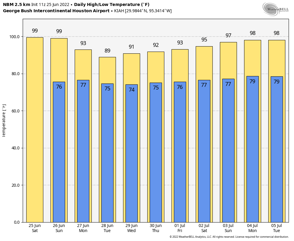
Accumulations are nearly impossible to forecast given the uncertainty at this point, but I’d guess most of the Houston region will receive 0.5 to 3 inches of rain, with a greater likelihood of rain near the coast. By Tuesday the increasing cloud cover should also drive daily temperatures back to around 90 degrees for a couple of days. Eventually this system should move west, clearing our area by later on Wednesday or Thursday.
As ever, tropical systems are dynamic, so we’ll be watching this closely. If the situation changes, we’ll update you on Sunday. If not, look for our regular post on Monday morning.
App note
We’re aware of an issue with the Space City Weather app in which it is not displaying the most current posts on some devices. Our developer has identified the bug and is working to push out an update soon. Please accept our apologies for the issue.
Work around for the app is to slide the page down so that it refreshes. Just like a regular browser window.
This works for some devices, but not others. It’s a persistent bug. There’s a solution but it will take a little time to deploy it.
Not a big deal if it take a little while. That’s why I get the emails and have the site bookmarked.
Thanks for the update!
I’m not at all cheering for a hurricane, but this post is 99% good news.
We desperately need the rain and this is the kind of system that can help with that.
Much appreciation. As I do every day or two, I checked TropicalTidbits and saw this exact potential scenario. Knew to wait until this morning to look into it after seeing that; glad you addressed it so well.
I’m a Channel 11 guy and, since they weren’t sounding overly worried last night, I knew to wait these 12 hours (and 2 model runs) to find out what you thought… and will check into it again tonight and tomorrow as forecast certainty will increase with each successive forecast. (it’s amazing what a few thousand extra data points on water temp, barometric pressure, and air temp do for the computers and the forecasters using them)
No problem out here in Richmond. Love this daily update, Eric & all. Great Houston area weather report! Tweeting . . .
100% good news!
Great news. Thank you for the update. Glad to know the app issue is not just me! I wasn’t sure how to report it.
https://www.cnn.com/2022/06/25/health/weather-forecasting-future-scn/index.html
Thanks for the weekend post Eric! I notice that this afternoon, the National Weather Service increased the probability of rain for the Houston area for next week Thursday and Friday to 40-50%, up from 20-30% earlier today. Hopefully this means the rain will hang around all week and give us a soaking without too much wind, or a deluge.
We live in Cypress, you don’t have our area on your app. Tomball is the closest but was hoping Cypress was an option. Love your site!
Thank you!
An update on the old-post issues with the Space City Weather app: Our developer pushed out a new version on Saturday (6/25) that should fix the problem. Please update your Android or iOS app ASAP. Thanks.