A warming trend through Sunday before uncertainty early next week

Good morning. The forecast for the Houston area remains more or less on track, with a warming trend through the weekend followed by some sort of front, and maybe some rain, on Monday or Tuesday of next week. I don’t want to make too much about the rain chances early next week—as some recent rain events have underperformed—but I am cautiously optimistic about what’s ahead.

Thursday

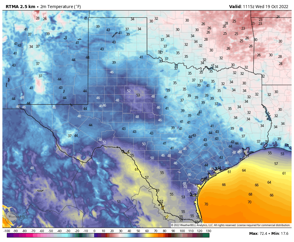
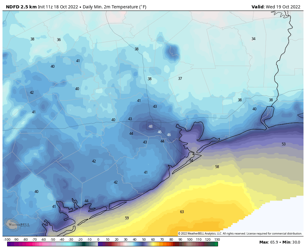
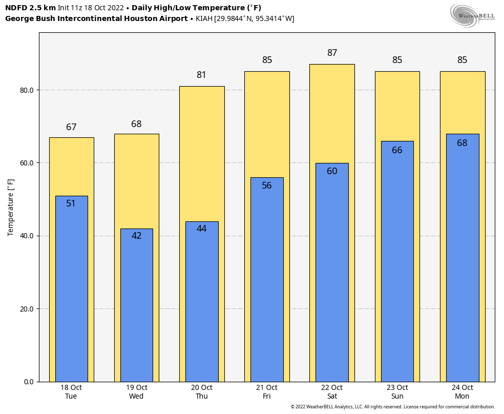
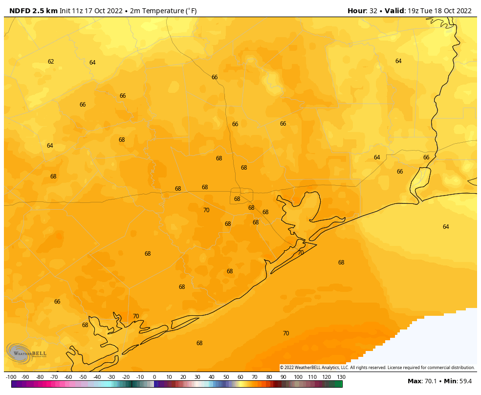
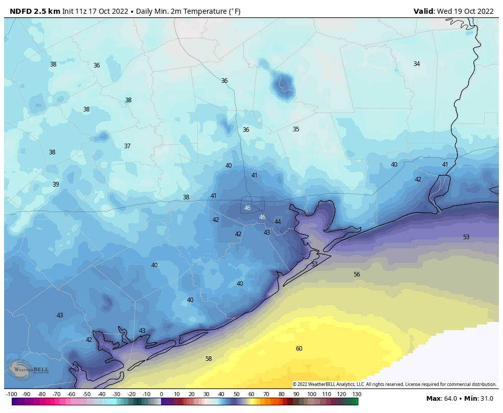
This will be our last cold morning of the week, with most of the area in the 40s. However change is afoot as high pressure moves off to the southeast, and our northerly breezes are replaced by a southwesterly flow. As a result highs today will be quite a bit warmer, reaching the low 80s, beneath mostly sunny skies. Winds will be out of the southwest at 5 to 10 mph. Lows tonight will drop to around 60 degrees in the city of Houston, with cooler conditions further inland.

Lows on Friday morning will be quite a bit warmer than 24 hours earlier. (Weather Bell)

Friday

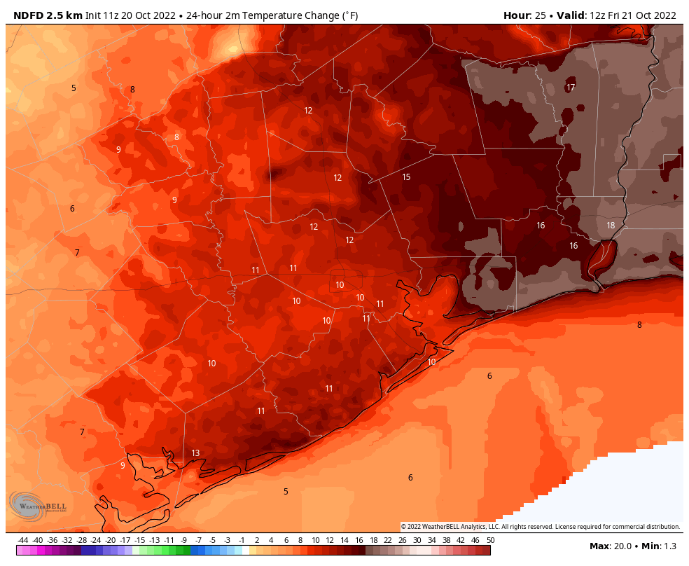
A warmer day still, with highs in the mid-80s beneath mostly sunny skies. Overnight lows will only drop into the mid-60s. There will still be a modicum of drier air, but it will gradually be blown away.

Saturday and Sunday

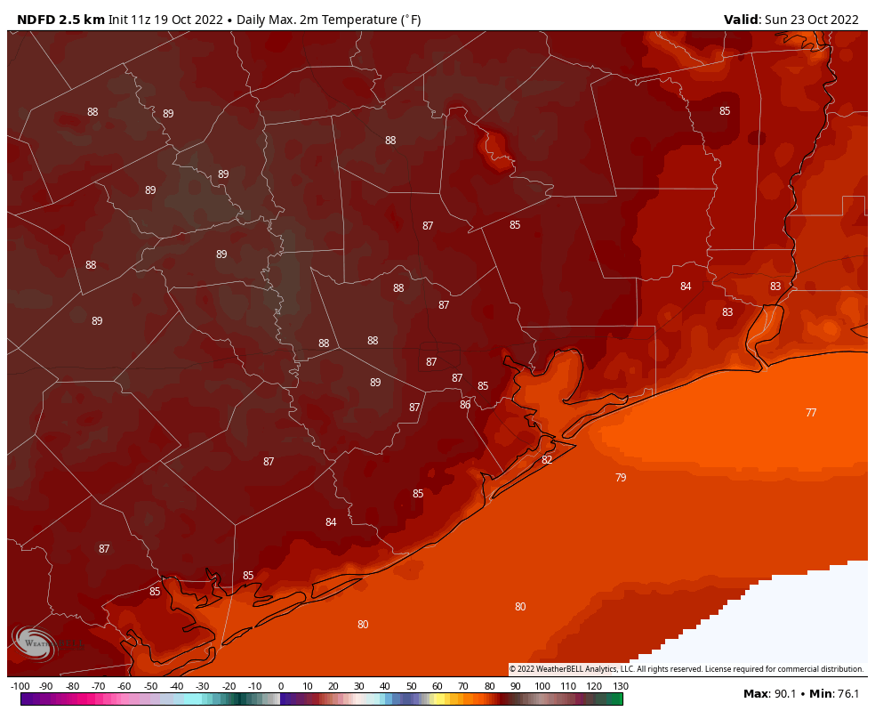
The weekend still looks warm, with highs in the mid-80s, and for some inland locations possibly the upper 80s, to go along with partly to mostly sunny skies. Humidity levels will be on the rise, but we’re not going back to summertime humidity. Overnight lows are unlikely to drop out of the 70s. Rain chances are not zero this weekend, but they’re probably on the order of 10 percent. So near enough for most purposes.

Next week

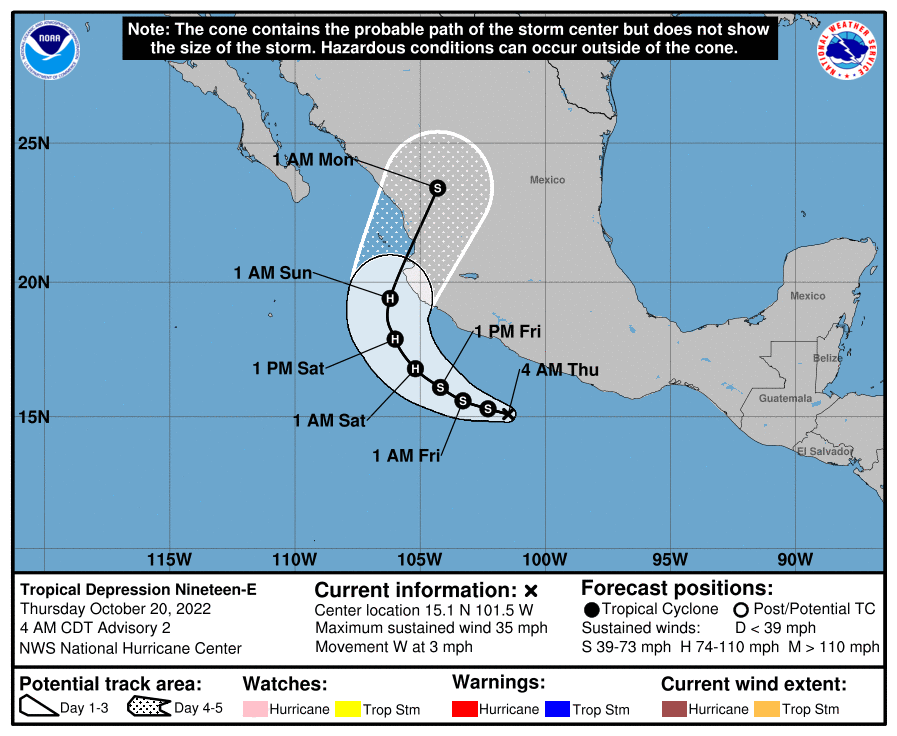
The big uncertainty in the forecast concerns the details of what happens next week. There remains a pretty large discrepancy in terms of the timing of the front, and that is important for determining our rain chances. Essentially, a Pacific Hurricane will be moving into Mexico this weekend, and it will push a large amount of moisture into Texas on Monday. If the front makes it through on Monday night or early Tuesday, it will synch up with this moisture and produce a decent amount of rainfall, perhaps 1 to 2 inches.

A Pacific tropical system will bring atmospheric moisture to Texas early next week. (National Hurricane Center)

However, if the front is later on Tuesday or Tuesday night, it might miss this slug of moisture, and our rain chances and potential accumulations will be less.

Broadly speaking, most of next week and weekend do look cooler as not only are we getting some sort of initial front, but a secondary push of cooler air is expected later next week. So probably we’re looking at an extended period of highs in the 70s and lows in the 50s and 60s. It should be rather fall-like and nice if it all comes together.

One more cool day before conditions start to warm up

Good morning. Temperatures have generally fallen into the low to mid-40s across much of Houston this morning, with a few colder spots such as the interior of Montgomery County—upper 30s—and a few warmer ones along the coast where lows remain in the low 50s. This will be the coldest morning of the week, but we’ll have one more chilly night before we warm up for the weekend. Next week’s forecast still looks a bit messy, but my expectation is for another front with some rainfall.

Texas temperatures as of 6:15 am CT on Wednesday morning.

Wednesday

Today will be sunny again, with highs in the upper 60s. Winds will be out of the north at 5 to 10 mph, before turning more southerly later today or tonight. Expect one more chilly night, with lows a couple of degrees warmer than Tuesday night. So again, most of the area should drop into the 40s away from the coast.

Thursday and Friday

As the onshore flow gets going, we’ll start to see a gradual rise in humidity levels, but Thursday should still see pretty dry air. Look for sunny skies and highs in the low 80s, with moderate southerly winds. Lows Thursday night will drop to around 60 degrees. Friday will be warmer, with sunny skies and highs in the mid-80s.

Saturday and Sunday

The weekend looks pretty warm, and it will feel especially so after the cooler weather preceding it. Look for mostly sunny skies and highs in the mid- to upper-80s. Overnight lows will generally drop into the upper 60s. Humidity will be back, it it won’t be full-on summertime humidity. Days will be fairly breezy, with southerly winds likely gusting to 15 to 20 mph.

Highs this weekend will push back into the mid- to upper-80s. (Weather Bell)

Next week

We’ll be watching a few things next week including a large trough of low pressure in the atmosphere moving across the plains along with a cold front, and a hurricane in the Pacific Ocean that could transport atmospheric moisture across Mexico and into Texas. While the big picture seems clear the details of the interaction between these weather systems over our area, as of yet, are not.

The bottom line is that I think we can expect to start to see more clouds by Sunday night or Monday, and an increase in rain chances on Monday or Monday night. The front itself will probably arrive on Tuesday or Tuesday night. Alas, how much rain we get, and how much colder and drier air moves in behind the front, remains very much uncertain. My general expectation would be on the order of half an inch of rain and nights in the 50s, but I don’t feel overly confident in that. Sometimes with these kinds of fall-like patterns we see quite a bit of rain, but so far there’s no big signal for that in the models. We shall see.

How low will temperatures go tonight?

Temperatures have generally fallen into the low-50s across much of Houston this morning, with plenty of dry air. Brisk northerly winds bringing in more dry and cool air today will set the stage for the region’s coldest night in at least six months, and maybe seven. The forecast low at Bush Intercontinental Airport for Wednesday morning is 43 degrees. The last time it got that cold here was:

  • April 9: 44 degrees
  • March 25: 43 degrees
  • March 13: 32 degrees

So we are guaranteed to have our coldest night since at least April 9 tonight, and there’s a good chance it will be our coldest night since late March or even earlier. There is no chance, of course, that we’re going to see freezing temperatures tonight anywhere near the Houston metro area.

Low temperature forecast for Wednesday morning. (Weather Bell)

Tuesday

It will be slow to warm today, with winds out of the north at 10 to 15 mph providing a chilly breeze all day. Skies will be sunny, with highs generally in the upper 60s. As the sun sets tonight, temperatures will drop accordingly. Most of the metro area will be in the 40s, with the immediate coast in the low 50s, and some far inland areas north and east of Houston dropping into the upper 30s.

Wednesday

A day a lot like Tuesday, albeit with slightly lower winds shifting to come out of the northeast. Lows on Wednesday night should be a degree or three warmer than Tuesday night.

Thursday and Friday

As winds shift to come from a more southerly direction, we’ll see a warming trend with sunny skies and highs in the low 80s. Overnight temperatures may drop into the 50s on Thursday night, but by Friday night they’ll probably remain in the low 60s.

Temperatures will be on the upswing for this weekend. (Weather Bell)

Saturday and Sunday

The weekend looks sunny and warm, with highs in the mid-80s, and nights in the 60s. While humidity returns, I think dewpoints will be under control enough such that it won’t be summer-sticky out there.

Next week

There is a fair amount of uncertainty about our weather next week. By late Sunday or Monday it’s possible that an atmospheric disturbance could spark some showers, or we could continue to see mostly sunny skies and warm weather. Then, by the middle of next week, there is a fair amount of model support for a strong-ish cold front to move in, with some pretty decent rain chances. But that is far enough into the future for our confidence to be fairly low. So … stay tuned. Maybe we’ll have a little bit more clarity by tomorrow.

Houston this week: Temperatures plunge from the 90s to the 40s

I’m not going to lie: for mid-October this weekend’s temperatures and humidity felt pretty gross outside. I know there are some people living here who love summer, and can’t get enough. God bless you. But y’all have had more than five months now. And after a high of 91 degrees on Saturday, and 92 on Sunday, it’s time for a change. Fortunately that is just what is coming with today’s front. In fact, a lot of the region in the 90s this week will be in the 40s (or possibly even upper 30s) by Wednesday morning.

Monday

The front has slogged to the coast already, but it will take some time for drier and cooler air to work its way down into Houston. Accordingly we’re seeing shower activity this morning across much of the northern half of the region, and this should shift closer to the coast later today. Overall rain chances are about 50 percent, with accumulations for those areas that do see rain on the order of one-quarter to one-half inch. High temperatures should remain in the 70s today, with winds out of north and northeast. Low temperatures tonight will drop into the 50s for most of the area, away from the coast.

Temperatures on Tuesday afternoon will be … in the upper 60s?!? You bet. (Weather Bell)

Tuesday

This will be a chilly day, with highs in the upper 60s to 70 degrees, to go along with mostly sunny skies. Houston will not have had a day as cool as this since March, about seven months ago. Breezy conditions out of the north, with gusts up to 20 mph, will add to the chill. This influx of colder and drier air will set the stage for a cold night, with lows likely in the low- to mid-40s for much of the metro area, and even chillier still further inland. Even Galveston Island should get down into the 50s.

Those Wednesday morning lows will be downright cold. (Weather Bell)

Wednesday

This will be another sunny and cool day, with a high near 70 degrees. Lows Wednesday night will be chilly again, but likely a few degrees warmer than Tuesday night.

Thursday and Friday

A warming trend begins toward the end of the work week as high pressure shifts to our east, and the onshore flow returns. Look for highs in the low 80s both days to go along with sunny skies.

Saturday, Sunday, and beyond

This weekend should see highs in the mid-80s with partly to mostly sunny skies. There is some question about whether another front will push through early next week, bringing some rainfall with it. Quite frankly there is broad disagreement in the models. For now my expectation would be a continuation of warmish weather, in the 80s and low-ish rain chances. We’ll see.