I’m not going to lie: for mid-October this weekend’s temperatures and humidity felt pretty gross outside. I know there are some people living here who love summer, and can’t get enough. God bless you. But y’all have had more than five months now. And after a high of 91 degrees on Saturday, and 92 on Sunday, it’s time for a change. Fortunately that is just what is coming with today’s front. In fact, a lot of the region in the 90s this week will be in the 40s (or possibly even upper 30s) by Wednesday morning.
Monday
The front has slogged to the coast already, but it will take some time for drier and cooler air to work its way down into Houston. Accordingly we’re seeing shower activity this morning across much of the northern half of the region, and this should shift closer to the coast later today. Overall rain chances are about 50 percent, with accumulations for those areas that do see rain on the order of one-quarter to one-half inch. High temperatures should remain in the 70s today, with winds out of north and northeast. Low temperatures tonight will drop into the 50s for most of the area, away from the coast.
Tuesday
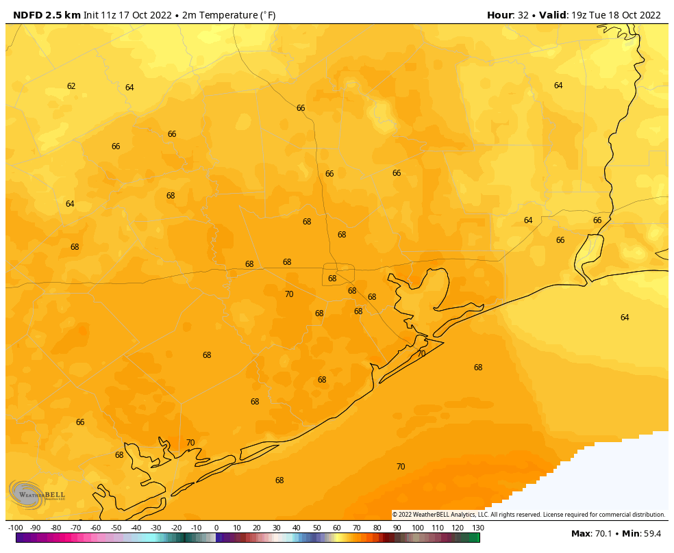
This will be a chilly day, with highs in the upper 60s to 70 degrees, to go along with mostly sunny skies. Houston will not have had a day as cool as this since March, about seven months ago. Breezy conditions out of the north, with gusts up to 20 mph, will add to the chill. This influx of colder and drier air will set the stage for a cold night, with lows likely in the low- to mid-40s for much of the metro area, and even chillier still further inland. Even Galveston Island should get down into the 50s.
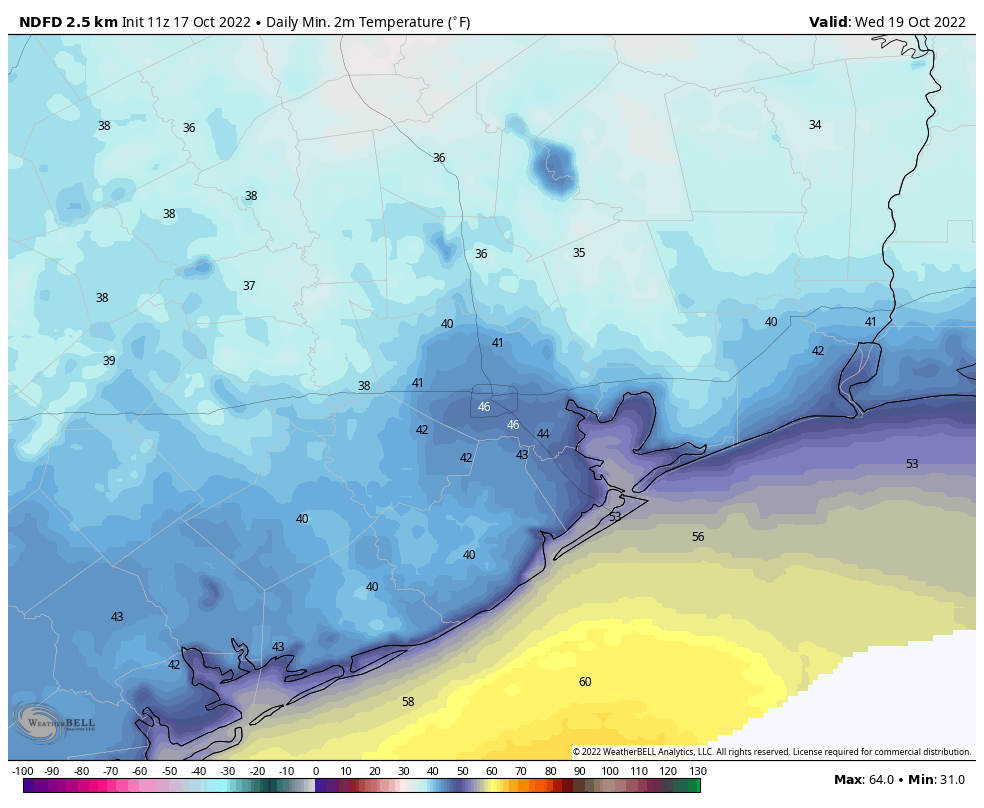
Wednesday
This will be another sunny and cool day, with a high near 70 degrees. Lows Wednesday night will be chilly again, but likely a few degrees warmer than Tuesday night.
Thursday and Friday
A warming trend begins toward the end of the work week as high pressure shifts to our east, and the onshore flow returns. Look for highs in the low 80s both days to go along with sunny skies.
Saturday, Sunday, and beyond
This weekend should see highs in the mid-80s with partly to mostly sunny skies. There is some question about whether another front will push through early next week, bringing some rainfall with it. Quite frankly there is broad disagreement in the models. For now my expectation would be a continuation of warmish weather, in the 80s and low-ish rain chances. We’ll see.


Was hoping for way more rain with this front. Seems like we need an entire week of rain just to catch up.
Thank you for mentioning Galveston.
BRING IT ON!!!
Well dang! Sounds like it’s time for a wardrobe change. The shorts will be put away and the long pants will be brought out!
Only til the weekend though
My heavily pregnant self is so happy; I cannot wait to open windows and let the cool fall air in—no A/C for a change. It’s divine.
And, another week of long-sleeve t-shirts and shorts. Hooray. For those who are already complaining that it warms back to the 80s with overnight lows in the upper 60s to low 70s, we don’t get lasting cool weather “for real” until Halloween (or later). But, I’ll count my blessings. This is another refreshing shot of cool air. I’m here for it!
You 100 degree lovers are sick.
I feel we were misled about the rain last week.
No you weren’t misled. models were trending towards more rain last week, but as it got closer to the front coming, weather patterns were different than the models were expecting hence less rain. Rain was expected but no guarantee it was going to be a drought busting amounts.
Trying to predict weather more than 48 hours in the future is like throwing darts randomly at a map (where it lands is anybody’s guess).
Absolutely cheated on the rain chance, again. There ought to be a law against it, somewhere.
We got an easy 2 inches+ this morning in North Tomball/ South Magnolia.
Most of the country would snicker to see “upper 60s to 70 degrees” described as “chilly”.
And on the flip side, we snicker when they call low 90’s “hot”.
Heck, I’ve been in the presence of people who called mid-80s hot, and I did indeed snicker.
A brief dose of late fall and then back to normal fall. I see the dew points rising later in the week up past 70 (the balmy humidity marker) and 85 and muggy still isn’t great, but at least it’s not 95 AND muggy.
they should have scheduled fall day for today. Damp and cool, dark, dank, with a side of mildew. That feels like fall.
the rain seems to be dissapearing before it gets here…
As usual
NOT ENOUGH RAIN. Not even 1in.
It’s not Halloween setup if I’m not sweating and swatting off mosquitoes.
So far, this October looks to be between 2.5 to 3 degrees F warmer than average, and the next three days are unlikely to make a significant difference to those numbers. There may be disagreement in the modeling, but most of the weather sites appear to lean towards highs in the mid to upper 80s (which translate to upper 80s to low 90s for inland areas) for the remainder of the month, so don’t plan on putting away the shorts and swim suits just yet
I remember when cold fronts lasted longer than 36hrs. Those were the days…