Late autumn chill arrives in Houston later today, and it should stay awhile

Happy Friday, and happy Veterans Day. Thank you to all those who have served so people like us can yap about weather. One-third of November is in the books now, and it’s the 10th warmest start to a November on record in Houston. The middle-third of the month will not be quite like that. In fact it looks downright chilly at times for next week. The change in seasons begins tonight.

Today

If you have any plans this morning, you should be fine. No real rain is expected, and other than a couple sprinkles on radar this morning, it’s quiet out there. By afternoon, things do begin to change. It will not rain everywhere, but we do expect scattered showers and storms to begin to pop up. Basically, if you have any plans after 2 or 3 PM, you do run the risk of running into showers.

The entire area is under a marginal (1/5) risk for severe weather today, with slightly higher odds in the Matagorda Bay and Corpus Christi areas. (NOAA)

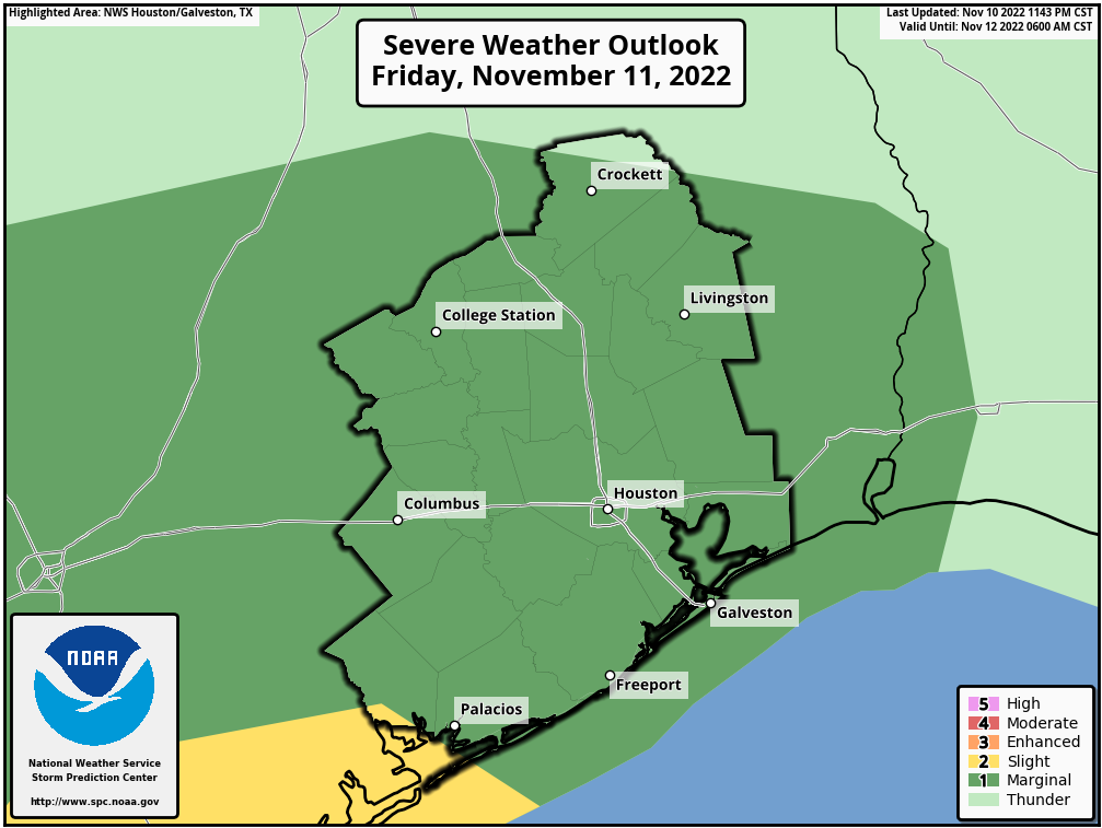
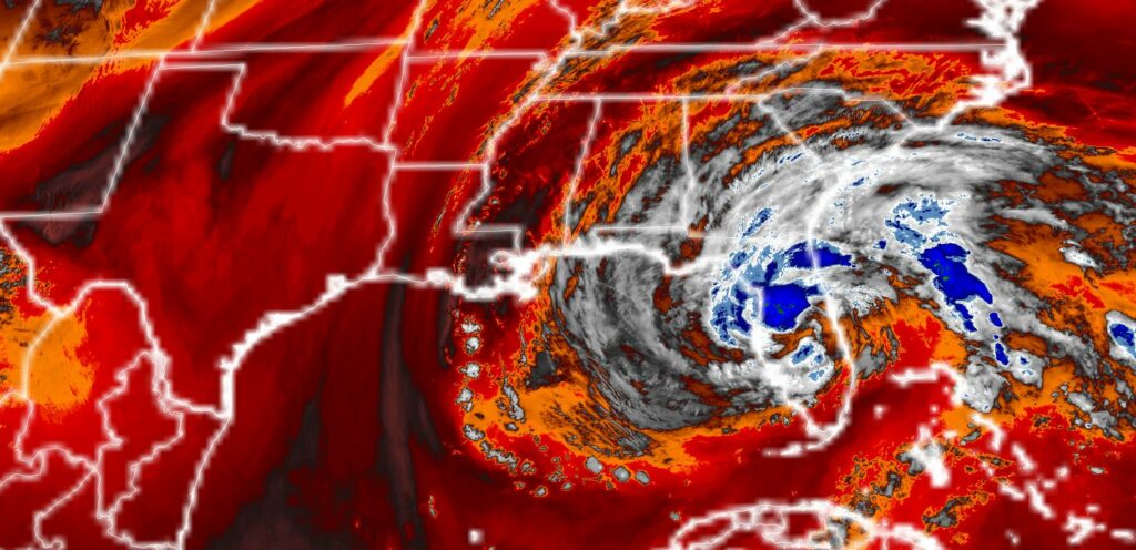
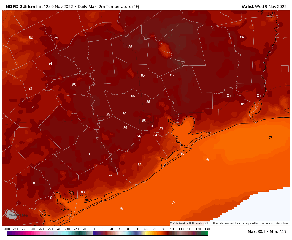
The Storm Prediction Center has placed us in a marginal risk (level 1 of 5) for severe storms today, with a slight risk (2/5) toward Matagorda Bay and Corpus Christi. Basically, any storms that develop this afternoon and evening could have gusty winds, frequent lightning, and the typical heavy downpours we see. Expect coverage of storms to slowly but steadily increase as we head toward evening. High temperatures should get to about 80 or so.

Tonight

The actual front itself will probably swing through the Houston area between 4 PM and 8 PM tonight (lean toward the earlier end of that range on the west side of town and later end of that range on the east side). Off and on rain showers or downpours with thunder should continue through midnight. It will turn breezy and quite chilly overnight.

Almost everyone will see lows in the 40s tonight and Saturday morning. (Pivotal Weather)

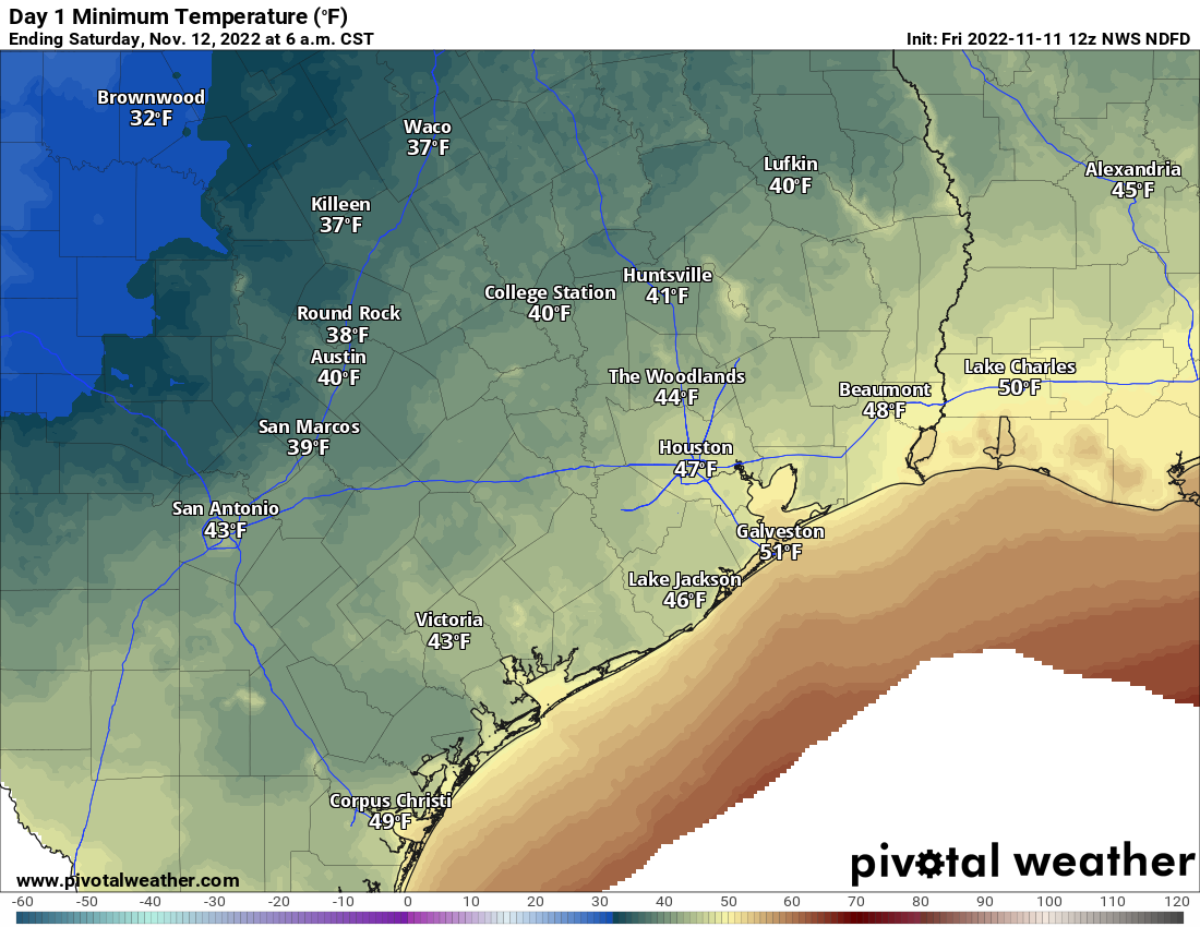
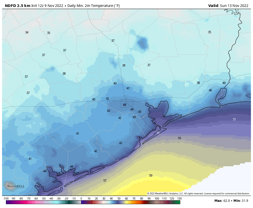
Look for lows in the 40s in most spots. With that, a gusty breeze will make it feel even a bit chillier. Be ready tomorrow morning!

Weekend

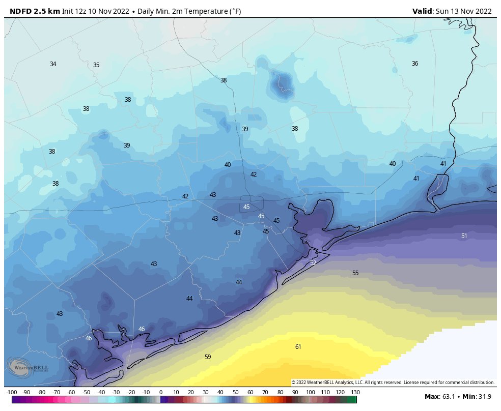
The weekend days both look fine. Tomorrow will have that somewhat annoying breeze in addition to temperatures in the 50s most of the day. Winds will be 15 to 25 mph. Sunday looks similar but less windy. Expect highs near 60 on Sunday afternoon after another morning of 40s.

Monday and Tuesday

Increasing clouds will build in for Monday with showers or rain likely developing as the day wears on. By evening, I would expect widespread showers or steady rain in most of the area. We’ll try to nudge back into the low-60s on Monday afternoon. Another cold front will push through on the back side of the rain Monday night, knocking us back into the 40s for Tuesday morning. Clouds may stay with us on Tuesday morning before clearing by afternoon, with highs in the 50s and a breeze.

Rainfall between Friday’s system and Monday’s system should add up to about an inch, maybe more across most of the area. (Pivotal Weather)

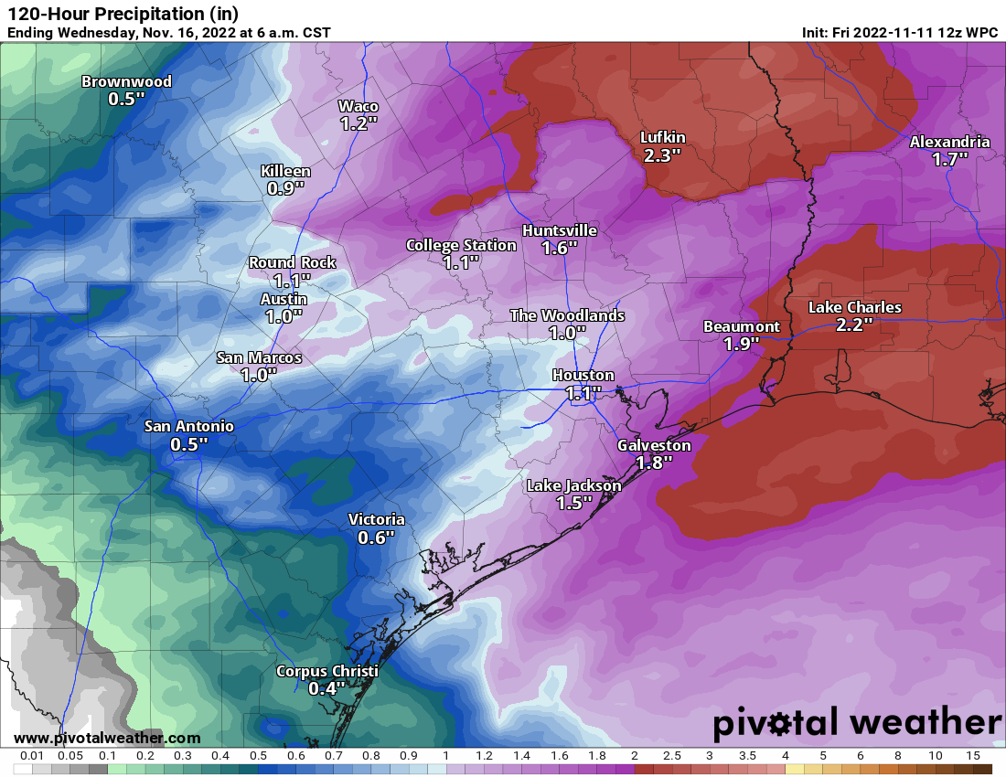
By the time we get to Tuesday, we will hopefully have all seen close to an inch or more of rain between today and Monday.

Rest of next week

The rest of the week will keep us in autumn mode with 50s by day and 40s or even 30s by night in spots. Freezing temperatures may be possible in outlying areas by Thursday or Friday morning. It still seems unlikely within the city, but we’ll see how things trend this weekend. At this point, further rain chances beyond Tuesday seem low.

Fundraiser

Like Eric, I want to extend our appreciation for all those who have either contributed or purchased swag during our annual fundraiser so far! You’ve still got time to purchase or donate to directly support our work. You can click here to do that. If you don’t wish to purchase merchandise and just make a contribution, click an item, click “buy/donate,” and check the box that says “I’d like to make a donation only.” Again, a sincere thank you for your support, and thanks as always for reading!

Winter is coming—no really, it is

The Houston area is seeing moderately drier and cooler air this morning, with lows in the mid-60s. We will continue a slight downward trend in temperatures until the arrival of a strong cold front on Friday that ushers in much colder air for the weekend, and beyond. It still looks as though inland parts of the area will drop down into the upper 30s by Sunday morning, so this should be our first real taste of what passes for winter-like weather in Houston, since March.

Thursday

Western parts of the area are again seeing some patchy fog, but this will burn off within an hour or two of sunrise as air temperatures warm. Highs today will likely be in the low 80s, with mostly sunny skies, and light easterly winds. Those winds will be transporting moderately drier air as a result of the overall circulation of Hurricane Nicole, which struck the eastern coast of Florida early this morning. Low temperatures Thursday night will drop into the mid-60s.

In this water vapor image, dry air is seen wrapping around the circulation of Nicole, and making its way into east Texas today. (NOAA)

Friday

Veteran’s Day will start out a lot like Thursday, and if you are attending any ceremonies during the morning hours the chance of rain is low. We will see the potential for at least some scattered showers during the afternoon hours, however, with the best chances during the evening hours before midnight. The front itself should move into the area, from northwest to southeast, during the late morning to late afternoon hours. As a result, highs on Friday will probably reach the upper 70s, with mostly cloudy skies. Temperatures will plunge overnight, into the 40s.

Saturday

Skies will be mostly sunny on Saturday, with highs topping out at about 60 degrees. Winds will be brisk, gusting out of the north at up to 20 or 25 mph, although these will start to ease off during the the afternoon and evening hours. Temperatures will bottom out on Saturday night, likely in the low 40s in central Houston, with cooler conditions further inland.

Low temperature forecast for Sunday morning in Houston. (Weather Bell)

Sunday

Skies should be partly to mostly sunny on Sunday, with high temperatures around 60 degrees. Lows on Sunday night will be about 5 degrees warmer that Saturday night as our air moderates somewhat.

Next week

Houston’s air will start to warm up, and become more humid on Monday in response to a more southerly flow. A low pressure system in the Gulf of Mexico is likely to bring a healthy chance of rain on Monday, as highs get into the mid- to upper-60s. But just as you think warm weather might be coming back, a reinforcing cold front will arrive later on Monday to bring winter-like conditions back. Most of the rest of next week will likely see partly cloudy days, with highs in the upper 50s to lower 60s, and nighttime lows in the 40s.

Fundraiser

On Tuesday Space City Weather kicked off our annual fundraiser, and we really appreciate the support so far. Head over here to our fundraiser page to choose from a selection of merchandise, or to simply donate money (select “make a donation only”). This is your one chance during the year to directly support the work we do!

Parts of Houston could drop into the 30s this weekend for the first time since March

Good morning! Houston will see one more day in the mid-80s today, with slightly cooler and drier weather to end the work week. And then, straight from the blue white north, a cold front will arrive and smack the region into late fall or early winter-like conditions, potentially driving low temperatures into the upper 30s for inland areas by Sunday morning. After that, we’re unlikely to see daily highs warmer than the 60s for at least the next week.

On Tuesday Space City Weather kicked off our annual fundraiser, and the support so far has been tremendous. Head over here to choose from a selection of merchandise, or to simply donate money (select “make a donation only”). Some sharp eyed readers noticed a minor error on the Four Seasons of Houston t-shirt. Thank you for letting us know. Rest assured that will be corrected before the shirts are printed and shipped.

High temperature forecast for Wednesday. (Weather Bell)

Wednesday

With dewpoints nearly matching air temperatures, some parts of the region are seeing fog this morning. This will quickly burn away as temperatures rise. We are going to see another mostly sunny day, with highs likely reaching the mid-80s. Overall, today should pretty much be a carbon copy of Tuesday. Overnight lows might be a degree cooler, but again much of the area will drop into the mid-60s. Of note: Today’s high will probably be the warmest temperatures we see for the remainder of 2022.

Thursday

Some slightly drier air will begin to work its way into the Houston area from the east, and this should help bring temperatures and humidity down slightly. Look for highs of around 80 degrees, with sunny skies. Overnight lows should drop into the low 60s.

Friday

A cold front will arrive on Friday, Veteran’s Day. If you are planning to attend ceremonies that day, I think conditions will be alright. Some scattered showers are possible during the daytime hours, but this does not look to be an in-your-face frontal passage. The bulk of the drier air will be delayed, and unlikely to move into Houston until later on Friday night, when surface winds will kick up. The bottom line is that we can expect scattered daytime showers, with highs probably in the upper 70s. Rain chances increase during the evening hours, with drier and colder air moving in after dark, and rains ending overnight. Much of the area will probably see between 0 and 0.5 inch of rain before sunrise on Saturday.

How low will Sunday morning go? (Weather Bell)

Saturday and Sunday

We’ll wake up to temperatures in the upper 40s to 50 degrees on Saturday morning. Skies should start to clear out some by the afternoon. Highs will probably reach about 60 degrees, but it will still be chilly out with a northerly breeze gusting to 20 or 25 mph. These winds should die down over night, and with clearing skies lows will drop into the upper 30s for inland areas, and low- to mid-40s for most of the rest of the region. This probably will be out coldest night since mid-March. Sunday should be partly to mostly sunny, with a high of around 60 degrees. Sunday night will be a few degrees warmer than Saturday night.

Next week

Most of next week will feel fairly winter-like for Houston, with highs around 60 degrees, partly to mostly cloudy skies, and lows in the 40s or perhaps low 50s. Some scattered rain chances will be sprinkled throughout the week. Looking even further ahead I’d love to be able to offer you some early guidance about what to expect for Thanksgiving, but it’s just too early to have any confidence, and I’d be a turkey if I told you otherwise.

Just how cold will it get this weekend? And our annual fundraiser begins today!

Good morning. In today’s post we’re going to discuss the four warmish days Houston will experience before a significant cooldown on Friday that will bring us much colder, fall-like weather for awhile. For those who have been pining away for a sustained stretch of sweater-and-hot-chocolate weather, your time is at hand.

This morning Matt and I also want to announce the opening of our annual fundraiser. Every November, for three weeks, we sell t-shirts, baseball caps, umbrellas, and more—as well as accepting donations only—to support the operation of the site. Your purchases and donations help pay for our server costs, fund the continued development of our weather app, and compensate everyone here at Space City Weather for our time. Every word we write is free, for all, thanks to your generous support.

This year we’re offering three different t-shirts and sweatshirts, as well as other merchandise. It all can found here on our 2022 fundraiser page. These items include:

You may also simply donate funds by going to any product page, clicking “buy/donate,” and then ticking the “donate only” box. Thank you so much!

This is one of our three t-shirt designs for this year’s fundraiser!

Tuesday

Houston faces a few more days of warmth before cooler air arrives. Today should be the sultriest, with mostly sunny skies, high temperatures in the mid-80s, and plenty of humidity. Winds will be light, out of the southeast, at 5 to 10 mph. We cannot entirely rule out a few isolated showers this afternoon, particularly southwest of Houston, but overall chances are probably on the order of 10 percent. Lows tonight will be a degree or two cooler than Monday night, dropping into the upper 60s for much of the region.

Wednesday

Houston starts trending toward slightly drier air on Wednesday, when we should see highs in the low- to mid-80s, light southeast winds, and mostly sunny skies. Temperatures Wednesday night should drop into the mid-60s.

Thursday

More modestly drier air will start to move into the area from the northeast by Wednesday night, and this will help bring down humidity levels a smidge. Look for highs around 80 degrees, with sunny skies, and overnight lows dropping into the low- to mid-60s.

Friday

Much more significant change is on the way Friday, with the arrival of a strong cold front. It’s not clear whether this will arrive during the daytime on Friday, or the evening hours, but it will bring a surge of significantly drier air into the region. Highs Friday will depend on the timing of the front, but upper 70s to 80 degrees seems like a decent bet. Right now I don’t anticipate too much in the way of showers or storms with the frontal passage, but it’s too early to say much with confidence. I’ll call it a 40 percent chance of rain, for now. Temperatures drop pretty quickly after the front passes, with gusty northerly winds.

Forecast low temperatures for Sunday morning. (Weather Bell)

Saturday and Sunday

Cold! This weekend will feel more like winter than fall. Both days will see a mix of clouds and sunshine, and high temperatures likely will peak in the upper 50s. Saturday will be a bit blustery, but winds should die down during the afternoon or evening hours. Lows on Saturday night should be the coldest of the week, possibly hitting 40 degrees just north of Houston. Sunday night should be almost as cold.

Next week

Something of a warming trend begins on Monday, but I think we’re going to stay in the 60s for high temperatures, for much of next week. It looks like the overall pattern may favor some mid-week showers followed by a reinforcing blast of colder and drier air. Did someone order winter? Because Mother Nature is door-dashing it to your home.