Good afternoon. As we get closer to Fall Day on Sunday, I wanted to share a final update on what you can expect if—excuse me, I mean when—you show up. Matt and I will be on hand, along with our webmaster Lee Hutchinson and web guru Dwight Silverman. Reliant has put a lot of work into making this a fun event for all, and they’re offering some great giveaways:
4 Houston Rockets tickets
4 Houston Texans Tickets
a Lance McCullers autographed baseball
a Michael Brantley autographed jersey
In addition, the first 20 people who show up can get a free, personalized paperback copy of my book on the origins of SpaceX, Liftoff. All you have to do is ask (and show up at 4 pm or shortly after).
We’re also going to have several activities for children, including face painting, and an assortment of fall-inspired fare that can be purchased separately:
Chaider (chai & apple cider)
Dirty Pumpkin Chai
Lemonade
Hot cocoa
Flavored Syrups (pumpkin, hazelnut, vanilla, caramel, sf vanilla)
Chocolate croissant
Pumpkin Muffin
As for the weather, it still looks warm-ish, but based on the latest data I anticipate temperatures in the low- to mid-80s in the Hermann Park area, with partly to mostly cloudy skies. Finally, there will be reserved parking available near the McGovern Centennial Gardens, so please be sure and look for the signs.
Look, it’s late October now, and it’s decidedly autumn. The weather and calendar this weekend are somewhat out of sync, but, you know, that’s to be expected this year. Anyway, the weather looks warm to hot in the coming days, but that will not stop us from celebrating the end of the extreme heat we all endured this summer. Please do join us on Sunday at the lovely McGovern Gardens in Hermann Park. It should be a good time. You can pregame with us before the Astros game 6 at 7 PM! Ain’t no party like a Scranton Space City Weather party!
Today
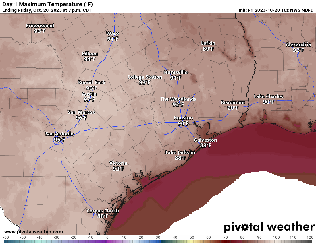
Friday will be one of those days where the right combination of ingredients comes together to potentially allow us to test records. Our official record high in Houston is 93° from 2004, and we currently have a forecast of 91° at IAH, where official readings are taken. Why? We’ll have a combination of an offshore wind, decreasing humidity, sunshine, and a relatively hot air mass in place. Drier air heats up more efficiently than more humid air, and thus we should easily make 90 or better today. Even though it’s cool this morning, you will want shorts this afternoon.
Today’s high temps make a map more becoming of September than late in October. (Pivotal Weather)
One other note: Today is also an ozone action day, meaning poor air quality so those of you that need to take precautions on those days should be exercising them today.
Weekend
Both weekend days should be fine with sun and clouds. Sunday may have more clouds than sun as the day progresses. Otherwise, look for a pleasant start to Saturday with 50s and 60s and generally low humidity. We’ll warm to 90 degrees or a touch hotter again. With clouds and increasing humidity on Sunday, look for a warmer morning with mid-60s or warmer, followed by a slightly less hot afternoon (mid to upper 80s). Saturday should see mostly light winds with a bit of a breeze out of the south on Sunday.
Next week
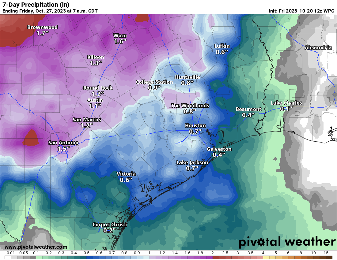
The forecast for next week will be dominated by a stalled out front over the Central U.S. and moisture being funneled up from the Pacific. The combination should produce locally heavy rain in interior Texas up through the Plains next week with several inches. Locally, the forecast is a bit trickier. With most forcing for storms off to our north and west, those areas may hog the majority of the moisture for most of the week, leaving us partly sunny and very warm and humid with just some scattered showers.
Rain totals over the next 7 days are not terribly impressive locally, with the majority of rain off to our north and west, but still some spots could end up taking in a half-inch to an inch of rain. (Pivotal Weather)
Basically, I would say to expect a couple periods of showers or storms next week, with the highest odds off to the north and west of the Houston area. But places like Abilene, Wichita Falls, and probably the DFW Metroplex would be more likely to see heavier, more organized rains next week. We’ll have more for you Monday!
Good morning. Warmer weather lies ahead for our region, with some 90-degree days for inland areas. But the hotter temperatures on Friday and Saturday (that’s the high weather) will be tempered by lower humidity and cooler mornings and evenings (and that’s the dry). We’ll also see mostly sunny skies for awhile, but eventually some better rain chances will return next week. See below for information on our Fall Day celebration Sunday.
Location of cool front before sunrise on Thursday morning. (Weather Bell)
Thursday
There’s a modest cool front draped across Central Texas this morning, roughly along the I-35 corridor. That will eventually bring us some drier air, but for today most of the Houston region will see somewhat muggy conditions to go along with sunny skies and highs in the mid- to upper-80s. The front will reach at least the northwest part of the Houston metro area this evening, bringing some drier conditions overnight. Inland areas will drop into the upper 50s, whereas areas closer to the coast are likely to remain in the low-60s.
Friday
After a cool start, temperatures will warm efficiently with dry air spreading into the entire region. Highs are likely to reach 90 degrees, or just above, for all areas except the coast, which will be a bit cooler. Skies will be sunny, and with lower dewpoints it will not really feel humid at all outside. Winds will be light, from the southwest. Overnight lows drop to around 60 degrees in Houston, with cooler conditions further inland.
Friday’s temperatures will be dry and high. (Weather Bell)
Saturday
The first half of the weekend will see sunny skies and highs around 90 degrees. Winds, again, will be light from the southwest. As the front washes out, we’ll start to see humidity levels rise some, and this increased atmospheric moisture will lead to a warmer night. Lows on Saturday night will probably only drop into the upper 60s for most.
Sunday
Increased cloud cover will help to moderate high temperatures on Sunday, which likely will reach the mid- to upper-80s. With dewpoints in the 60s, it will be a bit humid, but not oppressively so. By late afternoon conditions should be fairly mild outside, and I do hope you’ll join us for Fall Day from 4 to 6 pm at McGovern Centennial Gardens. I’m looking forward to hearing about your experiences during this torrid summer, and any forecasts that you think we particularly messed up on this year! Lows on Sunday night will drop to about 70 degrees.
Next week
The pattern for next week will basically be that of a warm, southerly flow. This means highs generally in the mid-80s, with partly cloudy skies, and mild nights with lows of about 70 degrees. We’ll see increasing rain chances by Tuesday or so, with decent accumulations likely by week’s end of perhaps 1 to 2 inches. As for the next real cold front, it does not appear likely to reach our region until some time next weekend.
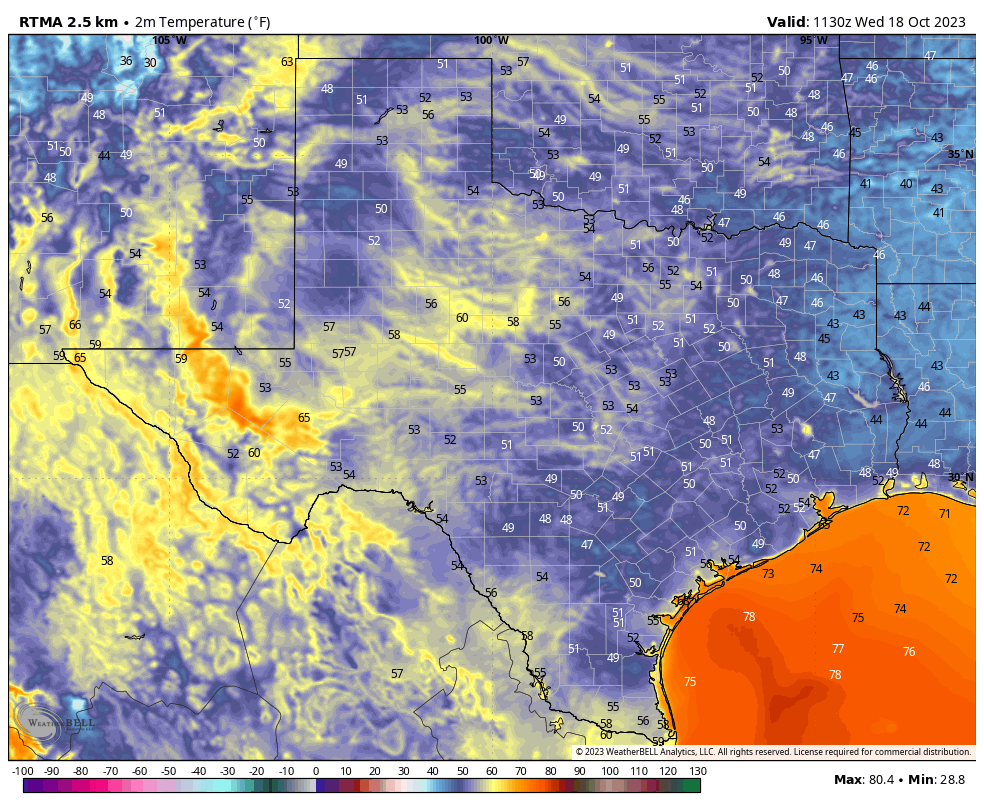
Good morning. Temperatures are generally in the 50s across the Houston region this morning, and this will be the last time we’re this chilly for about 10 days as our weather turns warmer and, eventually, a bit wetter. If you’ve enjoyed the cooler weather, take heart. It does look like we’ll return to much more fall-like pattern before the end of October.
As a reminder, despite the brief return to warmer weather, we’re excited to be celebrating Fall Day on Sunday. We’re gathering at McGovern Centennial Gardens, at the northern end of Hermann Park, any time from 4 and 6 pm for a festive meet-and-greet and fall activities for all ages—face painting, photo opportunities, seasonal treats and more! Admission is free. It’s not mandatory, but if you’d like to tell us you’re coming, please do so here. It will help with planning.
Much of Texas is in the 50s this morning. But the Houston area will now say goodbye to chilly air for awhile. (Weather Bell)
Wednesday
Winds have turned to come from the south, and this will allow us to warm to about 80 degrees today. Skies will be sunny, and those winds should remain light, in the vicinity of 5 to 10 mph. As dewpoints recover some, we’ll start to feel a little bit more humidity this afternoon and evening. Overnight lows probably will be about 10 degrees warmer than Tuesday night, dropping into the 60s.
Thursday and Friday
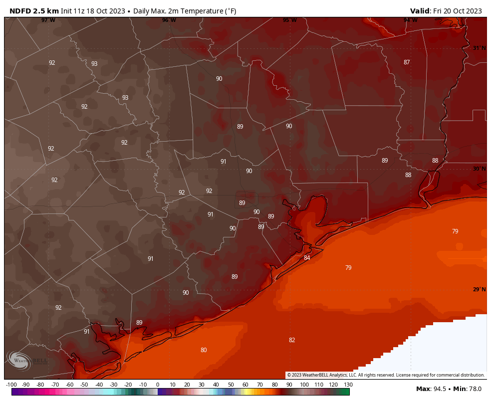
Our pattern turns decidedly warmer to end the work week, with an atmospheric flow generally from the southwest, which will help nudge temperatures into the upper 80s for much of the region on Thursday. A weak front will slowly slog through the area overnight Thursday, and this infusion of slightly drier air will help push temperatures a bit higher on Friday. Some inland areas will likely hit 90 degrees, although humidity will be lower.
Friday should be the region’s hottest day with a warmer southwesterly flow. (Weather Bell)
Saturday and Sunday
Lows will drop into the low- to mid-60s on Saturday morning, with drier air. However, the front’s influence will fade pretty quickly and we’ll see a more southerly flow. Look for a few clouds on Saturday, with highs in the upper 80s for the most part, with a few areas possibly touching 90 degrees. Some clouds will be possible on Sunday, with highs likely in the mid- to upper-80s for most of the area.
Next week
Our pattern will generally be warm and wet next week, although as usual we have some questions as to how wet conditions will get. Generally, days should be partly cloudy, with highs in the mid-80s. Rain chances will start to increase on Tuesday, and much of the area could see 0.5 to 2 inches of precipitation next week, give or take, as atmospheric moisture levels rise. The air will be fairly muggy. If you’re wondering where fall is, there is a fairly strong signal for a robust front by around next Friday or Saturday. That’s far enough in the future for it to be uncertain, but at this point I definitely think it’s likely.