Back to a slightly less harsh, rather brief dose of winter in Houston before next week’s rain

Summary: A hard freeze is likely north of Houston tonight, while much of the area sees 20s for lows. A light freeze is possible tomorrow night before we warm up. Next week’s rain chances are coming into better focus, with Monday and perhaps Wednesday seeing the most rain, but chances persisting all week long. Localized flooding is something we’ll be watching for, but we’re hopeful the rain is spread out over a long enough period to avoid anything too serious. We’ll have another update on this by Sunday.

Today & Saturday

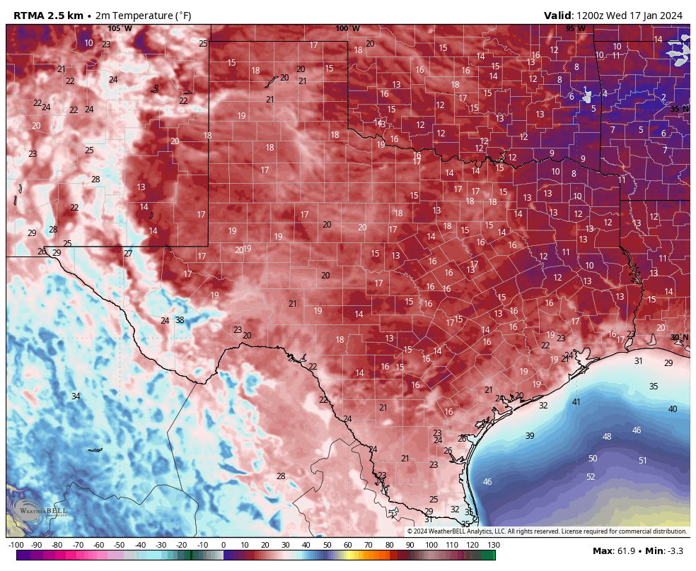
We’re back at it today, with gusty winds and chilly temperatures, as a second plunge of cold air descends on Texas. This one is much more moderate than the one we saw earlier this week, but still after yesterday’s mid-60s, today’s blustery 40s will feel cold. But, we have the sun, so that counts for something. Winds will be 15 to 25 mph, with gusts to 30 mph, stronger over the water.

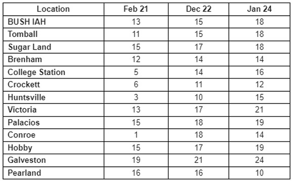
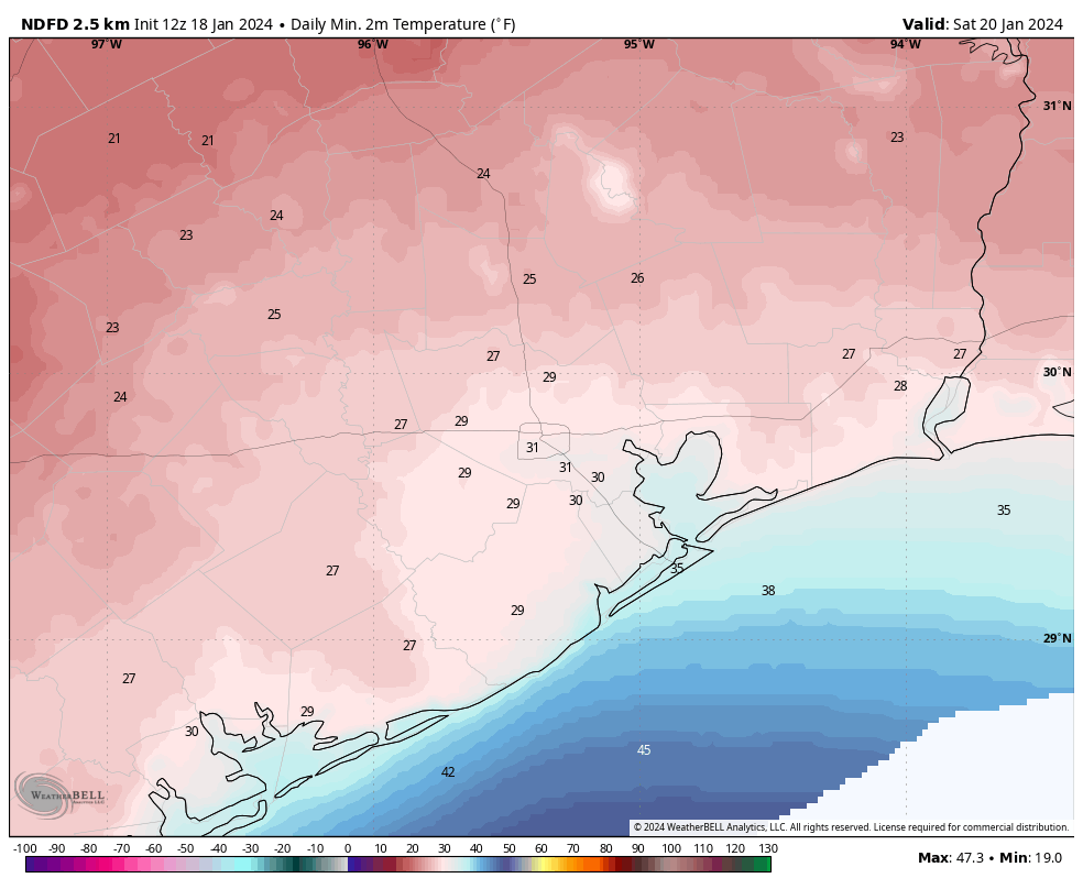
In terms of tonight’s freeze, as winds settle and skies remain clear, temps should drop efficiently into the 20s virtually everywhere away from the coast. For the city of Houston and most areas south or east, this will be a light freeze. Northern and western outlying areas are at risk for a brief hard freeze tonight, with lows expected in the mid-20s for The Woodlands, Conroe*, and Brenham. (*Conroe is always an interesting case given that they consistently record the coldest temps in the region, likely due to the location of the airport. So it’s possible they dip into the upper teens tonight)

Overnight lows will be in the 20s away from the coast, with low to mid-20s north and a hard freeze likely up that way. (Pivotal Weather)

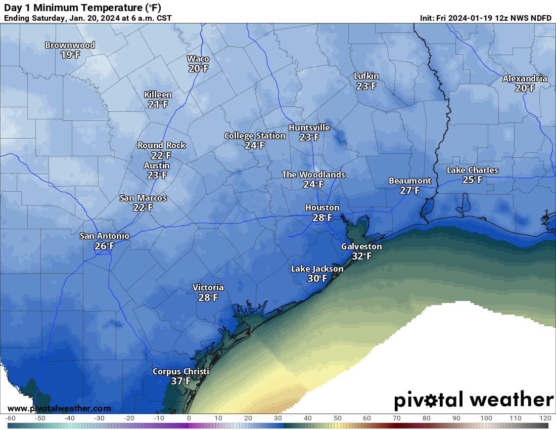
This will still be about 6 to 10 degrees milder than the hard freeze earlier this week but certainly still capable of hazards to exposed plants (and pets).

Saturday will be breezy and chilly but a little less harsh than Friday. We should see highs in the mid to upper-40s with breezes of 10 to 15 mph or a bit gustier at times. Expect sunshine as well.

Sunday

Expect one more risk of a freeze Sunday morning, mainly north and northeast of Houston. A hard freeze is unlikely anywhere in our area. We will see increasing clouds with a chance of a few showers as early as Sunday afternoon, as high temperatures slow-climb into the low-50s (40s again north).

Next week

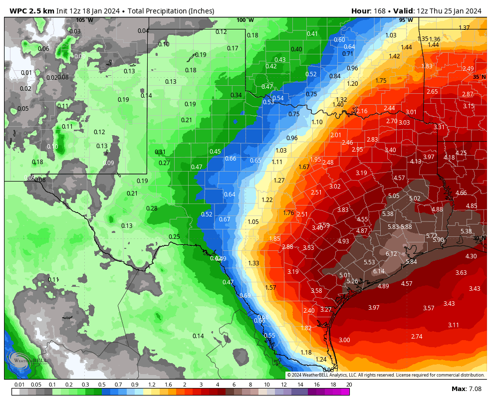
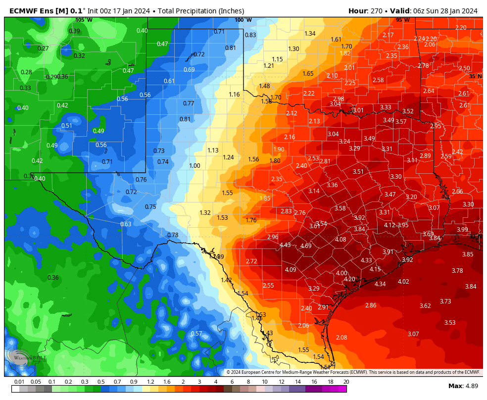
The rain we expect next week continues to show up in the forecast rather substantially. We’re starting to hone in on when the worst of it may be now. It looks like we have one pretty strong disturbance that moves through the area on Monday, which should mean numerous to widespread showers and thunderstorms.

The entire region between Victoria and Matagorda through Lake Charles is highlighted under a slight (level 2/3) risk of excessive rainfall on Monday. (NOAA)

This could deliver us anywhere from 1 to 4 inches of rain, and locally higher amounts can’t be ruled out. I would probably say the highest totals may fall to the south and east of Houston, but that is a very low confidence forecast call right now.

Tuesday should see isolated to scattered showers and storms. Rainfall should be a bit more erratic here, with some places seeing a quarter-inch or less and others another 1 to 2 inches perhaps. Then Wednesday may see another strong disturbance with the potential for at least another 1 to 2 inches over a broad area, with higher amounts.

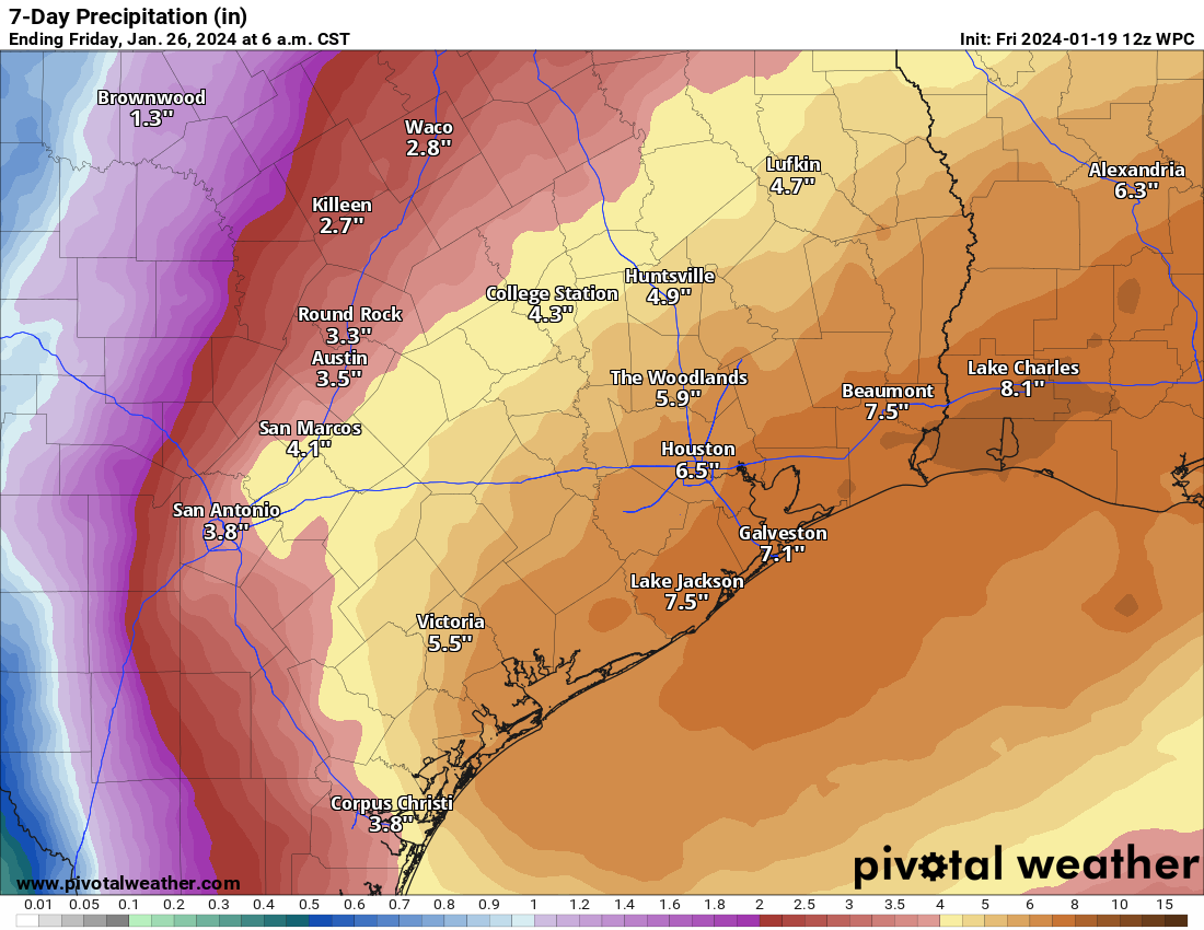
Additional shower chances will follow Thursday and Friday, but it’s tough to say what those look like right now. When all is said and done, the rainfall amounts will tally 3 to 8 inches by Thursday, with higher amounts possible.

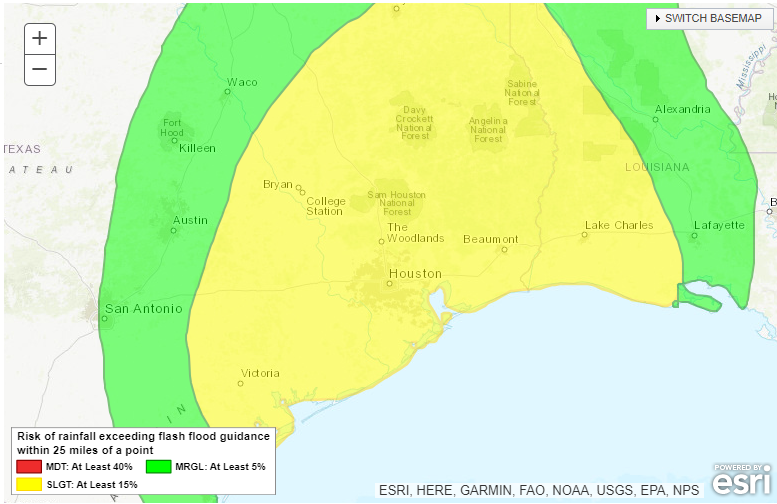
Does this mean flooding? It may. With the ground rather firm after this week’s freeze and the subsequent one this weekend, a lot of this water will be quick to run off, which means ponding and street flooding are a good bet in the usual trouble spots. The hope is that the total rainfall will be spread out over a long enough period with enough breaks in between that we avoid any more serious flooding, but it’s something we’ll continue to monitor this weekend. We’re going to especially watch to see how watersheds like Cypress Creek, Spring Creek, the San Jacinto River, and other slower responding basins handle this. This will also impact the Beaumont and Lake Charles areas to some extent. Which location wins the rainfall derby is still TBD.

After a cold weekend, a very mild week is in store. (Weather Bell)

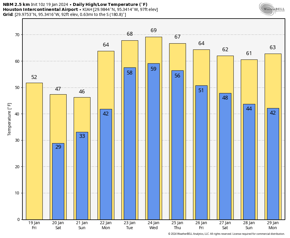
What about temperatures, you ask? We should see high temperatures well into the 60s most of next week with lows generally in the 50s to low-60s. This may also lead to periods of sea fog on Galveston Island, Bolivar, and along the bays. Maybe some cooler weather resumes by next weekend.

We will have another update for you by Sunday regarding Monday and next week’s rainfall, and I expect we will be implementing our flood scale then as well.

Recapping the hard freeze and looking ahead to heavy rainfall next week. Also, enjoy today outside!

Summary: The hard freezes are over, and Houston will have a pleasant, mild, and partly sunny day today. But after that? We’re going to cool back down again for the weekend, and then next week we’ll see widespread rain showers with the threat of heavy rainfall.

Recapping this week’s cold weather

Very hard freezes are supposed to be rather uncommon in Southeast Texas, but our region has now experienced three during the last four winters, in February 2021, December 2022, and January 2024. The worst of these was in 2021, when the cold was its sharpest, and most prolonged, with a winter storm on top of it. But the other two cold snaps, including this week, were significant. Here, via Harris County Flood Control District’s Jeff Linder, is a comparison of the coldest temperatures during each freeze:

Comparison of minimum temperatures during the last three hard freezes. (Jeff Lindner, Harris County Flood Control District)

Thursday

The combination of light winds and temperatures matching dewpoints has led to foggy conditions across much of the metro area this morning. This should dissipate by around 9 am, but until then please exercise some caution on roadways. Some very light drizzle is also possible this morning.

Winds will increase later this morning, and this southerly flow will help push temperatures into the upper 60s. Skies should be partly sunny, making for a rather nice afternoon. However a fairly robust cold front will sweep into Houston tonight, likely after midnight, to bring a new round of chilly air. Lows drop to around 40 degrees by Friday morning.

Friday

This will be a sunny, breezy, and cool day. Look for highs to reach the lower 50s. Winds will peak during the morning hours, with gusts up to about 30 mph possible as the front blows in. These should subside somewhat during the afternoon, with mostly sunny skies. We’ll see ideal conditions for cooling overnight, and much of the metro area could see a light freeze.

Low temperature forecast for Saturday morning in Houston. (Weather Bell)

Saturday

This will be a chilly day, with highs in the 40s and partly sunny skies. Lows on Saturday night will probably be a touch warmer than Friday night, but a light freeze will again be possible in parts of the area.

Sunday

Clouds return by Sunday, and they’re going to stay awhile. This will be another chilly day, although highs should get into the low 50s. Some light rain showers will be possible later in the day, but for now I think they’ll hold off until overnight when temperatures drop into the 40s.

NOAA rainfall accumulation forecast for now through next Thursday morning. (Weather Bell)

Next week

Most of next week looks warm and wet, with highs in the vicinity of 70 degrees, and nights perhaps in the upper 50s. As a series of disturbances cross Texas and meet with a favorably moist atmosphere, we’re going to see a fair amount of rainfall. I still don’t feel overly confident in totals, but I think much of the area probably will see on the order of 2 to 8 inches through Friday. Whether all of this comes in bunches, and we have to worry about flooding, is another matter. In any case, prepare for a significant pattern change that will bring a new round of concerns beginning next Monday or so.

Following the freeze, our focus turns to the potential for widespread rain showers next week

Summary: After a very cold night, Houston will emerge from the icebox over the next couple of days. Another front arrives Thursday night to cool us down for the weekend, when a light freeze will be possible. And after that? It will be warmer next week, with the likelihood of widespread showers. It’s too early to be too concerned about heavy rainfall, but something wet this way comes.

It’s another cold start to the day across Texas. (Weather Bell)

Wednesday

It’s really cold this morning. (Fun fact: Tuesday’s average temperature of 26 degrees was 28 degrees below normal. Alright, maybe that fact wasn’t that much fun). Temperatures across the metro area range from the mid-teens up in the middle of Montgomery County down to the upper 20s right on the coast.

Fortunately, this is as cold as it’s going to get. As soon as the Sun comes over the horizon, we’re going to see temperatures start climbing. Most of the region should be above freezing by 10 or 11 am CT this morning, on our way to highs in the mid-40s with sunny skies. As high pressure shifts to the east, we’ll see winds turning from the north to come from the southeast. As a result, lows tonight will only drop to around 40 degrees, with cloudy skies.

Thursday

This will be the warmest day of the week. Skies will start out cloudy, but we should see lots of sunshine during the afternoon hours. Look for highs to rise into the upper 60s to 70 degrees. Winds will be a bit gusty from the south, but it should feel pleasantly warm outside. But don’t get too attached as a front will come through on Thursday night, bringing an additional shot of colder air. The front’s passage should be a dry one, with lows dropping into the 40s overnight.

Enjoy your one ‘warm’ day this week, Houston! (Weather Bell)

Friday

It will be sunny and cold on Friday, with highs perhaps only reaching 50 degrees. It’s also going to be rather windy, with gusts up to 30 mph from the north. Friday night should see a light freeze descend upon Houston again, with a hard freeze possible for far inland areas. Still, this night looks nothing like the cold were presently experiencing.

Saturday

Saturday should start out brisk and sunny. Highs are likely to only reach the mid-40s, and we’ll probably see some clouds developing during the afternoon hours. (If you’re wondering about weather in Baltimore on Saturday afternoon for the Texans game, it looks blustery and cold. Game-time temperatures should be in the low 20s, with gusty winds up to 30 mph. The wind chill will be about 10 degrees. No chance of snow, however. In CJ we trust, right?) Back in Houston, temperatures will again flirt with a freeze on Saturday night, but I wouldn’t be surprised if the urban core of Houston stays above freezing.

Sunday

I expect the sunshine to be largely gone on Sunday, with highs perhaps in the low 50s, give or take. Rain is definitely coming, but at this point I expect it to hold off until Sunday evening or the overnight hours.

Next week

It’s a bit too early for confidence in the details, but we’re going to see some distinct changes next week. Instead of very dry air, our atmosphere will turn more humid, indicative of much more moisture. Temperatures are going up, with daytime highs around 70 degrees, and nights likely somewhere in the 50s. And we’re going to see a series of disturbances move in from the west that will increase our rain chances.

European model ensemble forecast for rainfall next week, through Saturday. This is broadly indicative of the favorable conditions for widespread, and possibly heavy rainfall. (Weather Bell)

Alongside this favorable setup, there is a pretty strong signal for rain showers during the period of Monday through Thursday across the models we look at. As a very preliminary guess, I’d say we’re probably looking at accumulations on the order of 2 to 6 inches. In the winter months rains pile up more quickly, because the evaporation rate is slower. So we’ll be keeping a tab on the potential for street flooding and other impacts. It’s not something to worry overmuch about right now, but if you have outdoor plans next week, well, good luck.

Hold on Houston, we’re almost through with the hard freezes

Summary: Houston faces one more very cold night before we break the back of this Arctic outbreak. Then we’ll warm up for a few days before another front arrives with some slightly less cold air to keep us on the chilly side for the weekend.

Much of the region has warmed above freezing temperatures this afternoon—if only just. Temperatures will peak over the next hour or so before they start dropping by around 4 pm CT. After that we’ll fall quickly this evening as the Sun sets and we see ideal conditions for radiational cooling. Much of the region is likely to be in hard freeze territory, which is to say temperatures below 25 degrees, by midnight. And then, we’re not going to drop much further. I think most of Houston will fall to about the same level they reached on Monday night, basically 17 to 23 degrees across most of our region. The immediate coast, including Galveston, will likely see another light freeze tonight.

Forecast for temperatures at 6 am CT on Wednesday. (Weather Bell)

The good news—and there is some—is that with light winds we’re not going to see quite the same chill tonight. But it will still be very cold by Houston standards. We’ll also warm up much more quickly on Wednesday than today, with the region rising above freezing by 10 am or so in the morning as the Sun comes up. Highs tomorrow are likely going toward the mid- to upper-40s. So not warm, but warm enough after what we’ve experienced.

Overnight lows on Thursday night look fine, in the 40s.

The vast majority of our area roads are looking good, so there are few concerns there. The electricity grid is in good shape as well. So let’s get through this night and then take a breath before the next front on Thursday night. That will probably bring a light freeze back to Houston by Saturday morning.

With this Arctic air heading to the exits after tonight, we’ll resume our once-a-day posting schedule on Wednesday morning. Thank you, as always, for reading and sharing our work.