After a windy day and a nice Saturday, cold arrives in Houston on Sunday followed by a chance of light icing on Monday

One front is through the region, and now we wait for the big dog front later in the weekend. First, we do have some wind to get through today.

Today

With the front to our east now, changes will be afoot today. We barely dropped below 70 (!) overnight, but we just crept into the 60s as I write this, and by the time you read it, it may be in the 50s. It will be a chilly one by mid to late morning. We’ll hold near or just above 50 for the majority of the afternoon. But it will be the wind that’s the real story today. Wind Advisories are posted, and we can expect wind gusts of 30 to 35 mph in Houston, and into the 40s over the bays and along the coast.

A reasonable estimate of what would be more like peak wind gusts today across the region, showing lots of 30-40 mph gusts and some stronger ones as well. (Pivotal Weather)

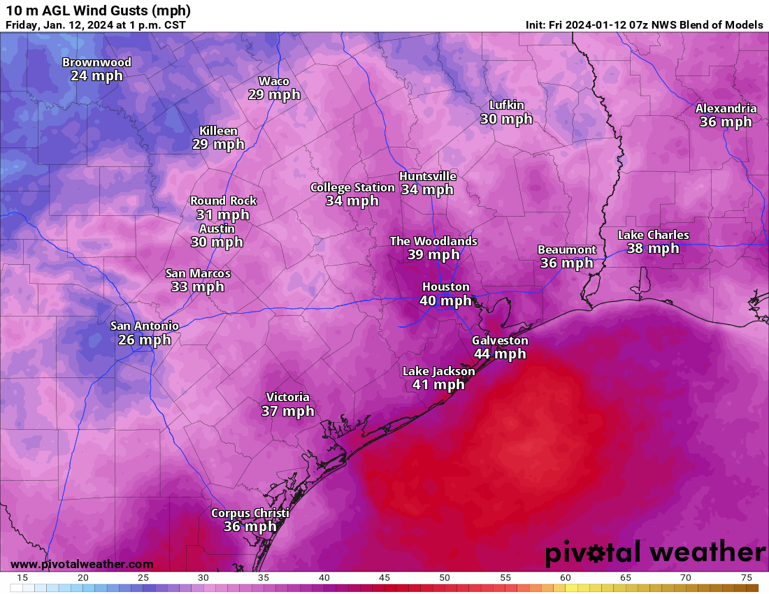
Winds will subside toward sunset, with a quieter night ahead. Look for lows tonight in the 30s in much of the area away from the coast. A light freeze will be possible north of the city and in some of the more sheltered areas south, west, or east as well. Temps should not be any colder than we’ve already seen this winter.

Saturday

A fine day. Highs should be around 60 or in the lower-60s. A great day to finish your winterization preparations. And go Texans!

User’s guide to the Arctic cold

With our two posts per day now, we are aiming to update with each main cycle of model data that we are able to see. So there should be fewer big changes with each post. I’m going to change up this post a bit to sort of hit on the key points rather than give a chronological forecast. Here’s what we know.

Key messages

  • Front hits Sunday morning ushering in cold (most areas well above freezing)
  • Temps in the 30s to near 40 with an east or northeast 10 to 15 mph wind for the Houston Marathon.
  • Light precipitation likely Monday and light icing on area roads is possible, especially north and west of Houston. Tuesday AM commute may be impacted in spots.
  • Temperatures may stay at or below freezing much of the time Monday morning through Wednesday morning.
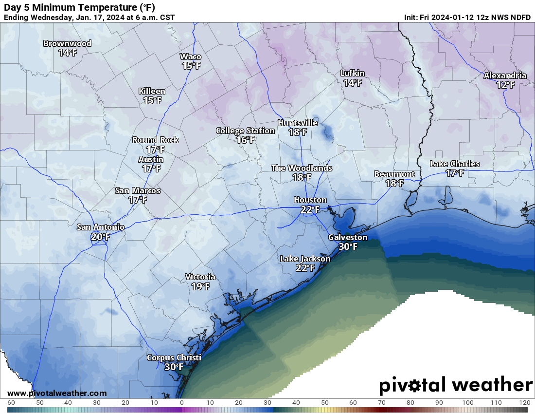
  • Hard freeze temperatures (less than 25 degrees) would likely last 8 to 10 hours at a time in Houston on Monday night and Tuesday night.
  • Wind chills will be as cold as 10 degrees or lower on Tuesday and in the teens much of Tuesday and Wednesday morning.
  • We warm well above freezing on Wednesday, with highs near 60 by Thursday.

When does it start?

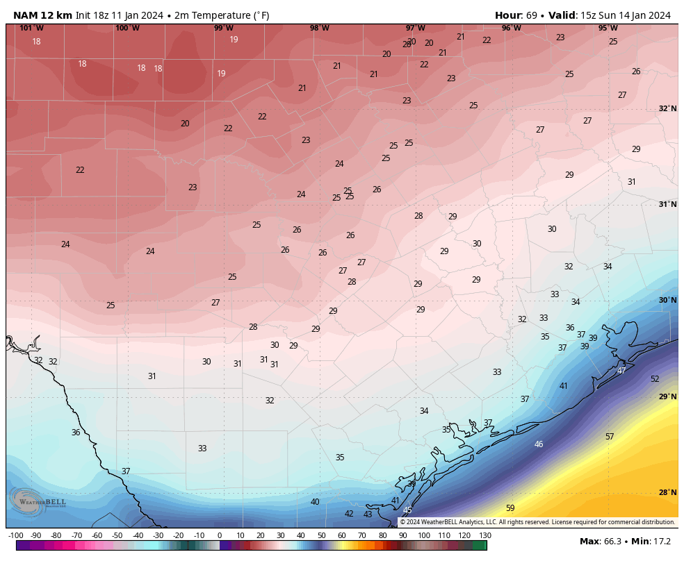
We need to think of this in two ways: When does it get generically cold and when do we see freezing temperatures? The answer to “when does it get generically cold” is coming into focus. The front looks to hit probably Sunday right around sunrise now. Temperatures in the 40s will probably drop back into the 30s as the front hits, with a light freeze possible north of about The Woodlands on Sunday morning.

A reasonable model forecast of temperatures at about 9 AM on Sunday: Cold but most places comfortably above freezing, except perhaps the College Station area and up toward Huntsville and Madisonville. (Pivotal Weather)

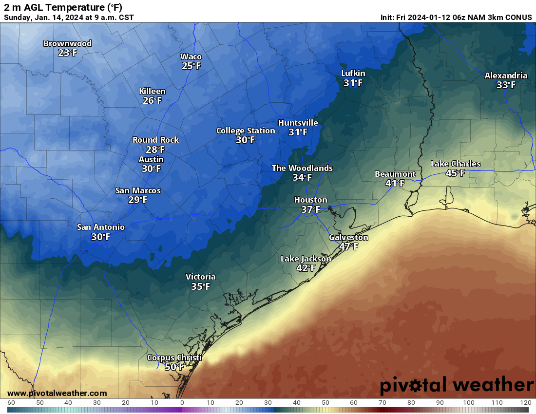
The rest of Sunday would be cold but dry with temps in the 30s. A widespread light to moderate freeze is possible Sunday night into Monday morning. A more consequential freeze is possible Monday night into Tuesday morning, with temperatures in the 20s probably everywhere but at the coast, struggling to get above freezing on Tuesday afternoon. And then the coldest on Tuesday night into Wednesday morning. Thankfully, we should bounce back well into the 40s on Wednesday afternoon.

The current NWS forecast for Bush Airport. It will be slightly colder than this to the north of there and slightly warmer than this in the city of Houston and south toward the coast. (Weather Bell)

This obviously brings up a couple additional questions.

How bad is the Houston Marathon going to be?

The answer to that question depends on your preference I suppose. I would expect temperatures perhaps dropping as runners are in motion. We may start in the 40s and drop into the 30s or start in the 30s and hold steady throughout. The wind? It doesn’t look horrific, but it doesn’t look great either. We expect northeast to east winds of 10 to 15 mph or so. There will certainly be some gusts near 20 mph at times in there as well. The more meaningful wind should thankfully hold off until Monday or Tuesday.

How cold will it get and for how long?

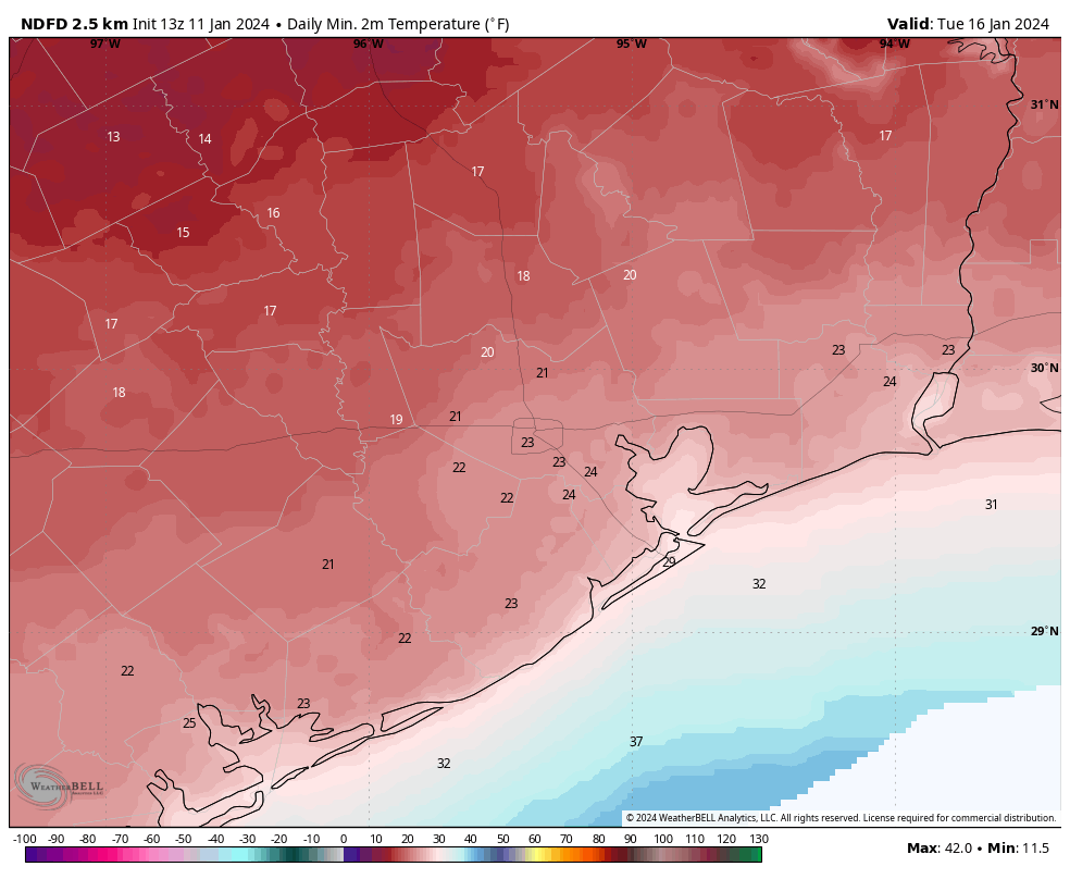
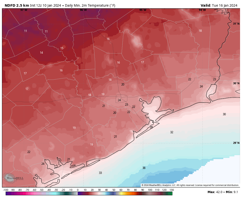
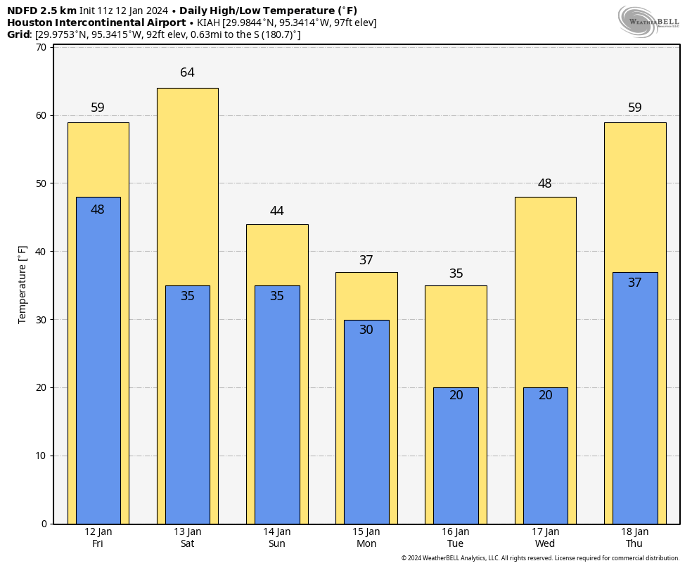
You can see the chart above for IAH. Let’s answer a few different questions. In Houston, the absolute worst case scenario right now would be temperatures dropping below freezing on Monday morning and staying there through Wednesday morning. Bear in mind that these would be temperatures more in the low-30s Monday (instead of the low to mid-20s like we saw during the February 2021 freeze). A more reasonable scenario is that we poke above freezing for a bit on Monday, then drop back Monday night and stay there into Wednesday morning. The coldest stretches (temperatures of 25 degrees or colder) will probably be limited to 8 to 10 hours at a time Tuesday and Wednesday mornings.

Wednesday morning should be the coldest morning of this event, and it’ll feel it for sure. (Pivotal Weather)

With gusty winds likely on Monday and especially Tuesday, look for wind chill values to drop into the teens much of the time, and at least for a time perhaps in the single digits. This is dangerous cold for pets and people outside, so please make sure to bring in the pets and check on anyone vulnerable to cold exposure.

Will there be wintry precipitation?

A disturbance passing over top of the cold air looks likely on Monday now. This will likely produce 12 to 24 hours of light precipitation across the area. With temperatures hovering near freezing, yes, that means we could see some freezing drizzle or light freezing rain as that precipitation moves through. There’s good news and bad news here. The good news is that amounts look light. So this isn’t going to be an all-out ice storm with lots of power outages due to ice buildup.

The bad news is that any amount of ice can make travel difficult. Monday is a holiday so there will be fewer people on the road already. That’s good news, but if for whatever reason you have to go out on Monday, please check on area roads before you leave. DriveTexas.org is a good resource to have. The Houston TranStar website will show you areas of ice. While there is still uncertainty on exactly how cold it will be Monday, it will be close enough to freezing to think that at least patchy ice will be possible on area roads, especially north and west of Houston and on freeway flyovers.

We don’t want to get into the prediction of traffic or school closures, but yes, you will want to pay attention to how things evolve this weekend for going to back to school or work on Tuesday, as Monday’s conditions could directly impact Tuesday’s commute too.

Will my flight be impacted?

We don’t predict airline behavior here, but yes, probably at some point Bush and Hobby will have some issues, but hopefully nothing major.

When does it end?

As you can see from the temperature forecast above, once we get above freezing on Wednesday morning, we are probably going to stay there into Thursday, with temperatures even near 60 degrees possible! Colder weather should come back next weekend, but it will likely be milder than we will see early next week. We will have more, including a broader look at Texas during this freeze event later today.

Afternoon update on the Arctic front: Here are the three main things we’re watching

As promised, we’re providing a p.m update on the cold weather we’re anticipating that will arrive in Houston, beginning Sunday. We’ll be doing twice-a-day updates through the weekend to keep you abreast of what’s happening—this is a fairly dynamic situation, and the forecast is changing as a result.

This afternoon we want to try and provide some clarity on what we think are the three biggest issues: timing of the cold weather onset, chances for wintry precipitation (i.e. freezing rain), and how cold it is going to get early next week. What about electricity? At this time we don’t think there will be widespread power outages with this cold outbreak. While that it is possible, it is beyond our ability to forecast. But given that the Texas power grid held up during the 2022 freeze, there is no credible reason to think it will buckle with this cold weather outbreak.

NAM model forecast for temperatures at 9 am CT on Sunday. (Weather Bell)

When will the front arrive

The majority of model data now supports a faster arrival, with the cold front initially reaching the Houston area on Sunday morning. If this ultimately happens, it has implications for the Houston marathon, both the runners and wonderful volunteers. This forecast is still uncertain, but it seems likely that race time temperatures will be in the upper 30s to low 40s. Right now I’d lean toward 30s.

Fortunately, the passage of this front is likely to be dry. There also is no indication, at present, of strong northerly winds. So while there may be gusts on the order of 15 to 20 mph, I don’t see much evidence of crazy strong winds we sometimes get with “blue norther” fronts. So expect partly sunny and cold on Sunday, with daytime temperatures perhaps in the upper 30s. We should have more confidence in these temperatures in a day or so. But confidence is high that it’s going to be cold.

The very coldest air is going to be delayed, so my expectation for Sunday night is that much of the region will probably experience, at most, a light freeze. This really should not raise too much of a concern. Daytime temperatures on Monday should be above freezing for most of the region.

Chances for wintry precipitation

Sunday looks dry, as does Sunday night. After that? Well, quite frankly it’s too early to say too much. There appears to be a chance of freezing rain during the afternoon or evening hours on Monday. My best guess is, at this point, that the freezing stuff stays north of the metro area. It could be an issue for areas along and north of Texas State Highway 105. It could surprise us and come further south.

So I would say this: We need to consider the possibility of icy roads on Monday evening and during the overnight hours into Tuesday morning. I think it’s a fairly low concern within the Houston metro area, that is for The Woodlands and points south. But with that said, it’s far too early to issue any kind of guarantees. We’ll be watching this closely in the coming days, of course.

Low temperature forecast for Tuesday morning in Houston. Subject to change. (Weather Bell)

How cold things will get

Our real concern for cold will come starting Monday night. Temperatures will bottom out in the morning hours on Tuesday and Wednesday. The forecast remains fuzzy because there are a lot of factors that will go into how low things get, from clouds to winds, to the amount of Arctic air that spills into Texas. But a good guess is that both nights will see lows in the upper teens to low-20s north of Interstate 10, and low-20s south of Interstate 10. The coast may avoid a hard freeze.

Daytime temperatures on Tuesday probably will briefly get above freezing for most of the metro area, but my confidence in that is fairly low. Houston should then warm comfortably above freezing on Wednesday.

We’ll have a comprehensive update for you on Friday morning.

Arctic air is coming to Texas, possibly as early as Sunday morning

Good morning. There are some changes in the forecast for our upcoming cold spell, which looks to arrive earlier than anticipated. There is also a slight chance of some wintry precipitation on Sunday night into Monday morning, but the overall odds remain against this for now. The key point is this: There remains a lot of uncertainty about the details of this Arctic outbreak, but they should come into better focus over the next 24 to 36 hours. So please be patient. Matt and I will be here all along the way to tell you what we know, and what we don’t. For now, any preparations you make for the cold should be completed by the end of Saturday.

Thursday

As expected there is fog, some of it dense, across much of the metro region this morning. As it clears we’ll see partly sunny skies and warm temperatures today, with highs pushing into the mid-70s. Southerly winds, gusting at times to 20 or even 25 mph, will be possible. Conditions change tonight as a fast-moving front drops through the area. Expect it to arrive near Katy and The Woodlands a couple of hours after midnight, push into Houston during the wee hours, and move offshore before sunrise. A broken line of showers, and possibly a few thunderstorms, may accompany the front. Overall rain chances are fairly low, however, as I expect a capping inversion to hold sway.

Highs will be in the 70s today … for the last time in quite a while. (Weather Bell)

Friday

This will be a cold, blustery day. Skies will be sunny, but winds will be strong out of the north, gusting to 35 mph or so at times. If you’re like me and just finished picking up limbs from winds earlier this week, prepare for round two. Highs will reach the upper 50s, but may stop there. Winds will drop off pretty significantly during the afternoon and evening hours, and this will allow for ideal cooling conditions overnight. I expect lows in most of the Houston metro areas to remain above freezing, but a light freeze is possible for inland areas.

Saturday

After the cold start this will be the last warm-ish day before the Arctic front arrives. We’re looking at partly sunny skies, with high temperatures in the low 60s. Winds will be light. Lows on Saturday night will drop into the low- to mid-40s.

Sunday

Alright, here’s where the uncertainty kicks in. We’re just coming into range of some of the higher-resolution models, which tend to do a better job handling the timing of colder air masses like this. As we see additional model runs today, we should continue to get a better focus on the timing of the front. So I want you to understand that my confidence is low here, and we’re going to need to write the forecast in pencil for a little while.

With that said, the high resolution modeling is indicating that the front could reach Houston by around sunrise on Sunday. Yes, you read that right. If this is the case, temperatures on Sunday morning could be in the 30s for Houston marathon, with northerly winds. (I don’t expect precipitation at this time). This obviously is a significant change from previous forecasts, and something we’ll need to fine-tune. Again, it depends on the timing of the front.

A widespread freeze looks likely for Sunday night, with areas inland of Interstate 10 possibly seeing lows in the mid-20s.

As to the question of freezing precipitation, there are hints of it in the models but nothing concrete. We really need to see more data from the high-resolution outputs before I have any confidence. For now I’d rate the chance of seeing any wintry precipitation, either in the form of sleet or freezing rain, at about 25 percent. I still don’t think it will be significant issue for roadways, but obviously it’s something we’re going to be watching closely.

Current forecast low temperatures for Tuesday morning. (Weather Bell)

Monday

This will be a cold day, with highs likely in the mid-30s for most of the metro area. As part of this Arctic front, lows will bottom out on Monday and Tuesday nights. Again, with these temperatures, there is some considerable uncertainty. For areas south of Interstate 10 we are probably looking at lows in the low to mid-20s, whereas areas further inland will be upper teens to low 20s. We will see.

We’ll have another update this afternoon to see where we are with the frontal timing, and lows early next week.

Setting expectations for next week’s freeze: Prepare, but don’t panic

Good morning. As you have probably heard by now, Houston faces the prospect of a hard freeze next week as an Arctic front moves through much of the continental United States. This will be serious cold for the Houston region, and will warrant some preparation. However, this is unlikely to be a disaster on the level of the February 2021 event that sapped the power grid and caused widespread pipe failures. It should be more akin to the February 2022 freeze, which the power grid (and most residences) tolerated much better.

Current forecast for low temperatures on Tuesday morning. This is far from locked in. (Weather Bell)

In terms of air temperatures, we are going to see some seriously cold (for Houston) weather next Monday night and Tuesday night. While there is still considerable uncertainty in how far the mercury will drop, lows are likely to drop into the upper teens to mid-20s for much of the Houston metro area. Here are some suggestions for preparing for this event:

Plants: Bring potted plants inside your garage or home. Apply a thick layer of mulch around ground-based plants, and water them. Cover sensitive plants with a sheet.

Pipes: Cover or insulate exposed pipes, including those under raised homes. Turn off and drain water sprinkling systems. Indoors, open sink cabinets to expose pipes to inner warmth.

Pets: Bring pets indoors and ensure adequate warmth for livestock.

People: Check on your family and neighbors to ensure their homes are winterized, or see if they need a warm place to stay.

Wednesday

Winds have already shifted to come from the south this morning, so after a chilly start in the upper 30s we are going to see highs push into the mid- to upper-60s beneath sunny skies. Winds will at times turn a bit gusty. Lows tonight will only drop into the mid-50s. The combination of light winds, warm air, and cool ground will lead to the likely development of fog tonight.

Thursday

That fog will be thickest on Thursday morning, and you’ll probably want to leave some extra time for the morning commute or getting to school. It could linger into the mid-morning hours. Skies will then turn partly sunny, with high temperatures likely reaching the mid-70s. A robust cold front will approach and move through the Houston region on Thursday night. This could result in a broken line of showers and thunderstorms, but at this point accumulations look slight. We can’t entirely rule out some damaging winds or hail with the front, but overall severe storm chances seem fairly low.

Severe storm outlook for Thursday and Thursday night. (NOAA)

Friday

This will be a sunny and chilly day, with high temperatures of about 60 degrees. Winds will be very gusty, perhaps up to 35 or 40 mph during the afternoon hours. Winds should slacken somewhat on Friday night, with clear skies allowing temperatures to drop to near, or just above freezing in the Houston metro area.

Saturday

This should be a pleasant, sunny and winterlike day in Houston. Look for highs of around 60 degrees. Lows on Saturday night will drop into the mid-40s.

Sunday

Skies will be partly to mostly sunny. If you’re running the marathon, after the chilly start in the 40s, we can expect temperatures to reach about 60 degrees by noon, and then a bit warmer during the afternoon. The air will feel reasonably dry. Winds during the run will be out of the south at 10 to 15 mph.

The Arctic front will be arriving later on Sunday in the Houston metro area, likely during the evening hours. There may be a bit of precipitation with the front, but it looks like this will end before temperatures drop below freezing—so at this point I would bet against snow, sleet, or freezing rain. Lows on Sunday night should drop to around freezing in Houston.

Next week

As we start the week, M.L.K. Day is going to be cold. High temperatures may not climb out of the 30s, with a mix of sunshine and clouds. So, brrrr. Temperatures bottom out on Monday and Tuesday nights, with lows likely dropping into the upper teens to lower 20s for much of the Houston metro area. We’re far enough out that some uncertainty remains in how far temperatures will drop (on the lower end, mid-teens are possible, and on the upper end most of the region could stay above 25 degrees). Expect highs to rebound into the 50s on Wednesday, with nights likely staying above freezing after that—but still cold.