Summary: The forecast remains on track, with a warmer and wetter period for the next few days ahead of a cold front on Sunday. That will bring sunnier, cooler, and drier weather back into Houston for a few days. If you’ve been wondering about the vague rumors about another polar vortex outbreak at the end of the month, Matt addressed them yesterday.
Thursday
It’s quite a bit warmer this morning across the region, with lows only dropping into the low 60s with a southerly flow in place. Skies will be cloudy today, with a light to moderate wind from the south, and highs pushing into the low- to mid-70s. The question is whether it will rain, and for the most part the answer is no. A few areas will see some light showers, but I expect them to be isolated with almost unmeasurable accumulations. Lows tonight should drop into the low 60s, with the possible development of some light fog.
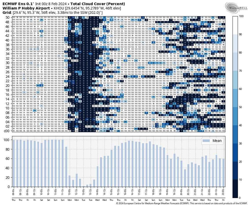
This cloud cover forecast from the European ensemble model tells the tale: But for a brief period of sunshine on Monday and Tuesday, there’s a lot of cloud cover ahead. (Weather Bell)
Friday
This day will be quite similar to Thursday, with the exception of a bit gustier southerly winds. Friday night will be warm again, with a slight chance of showers.
Saturday
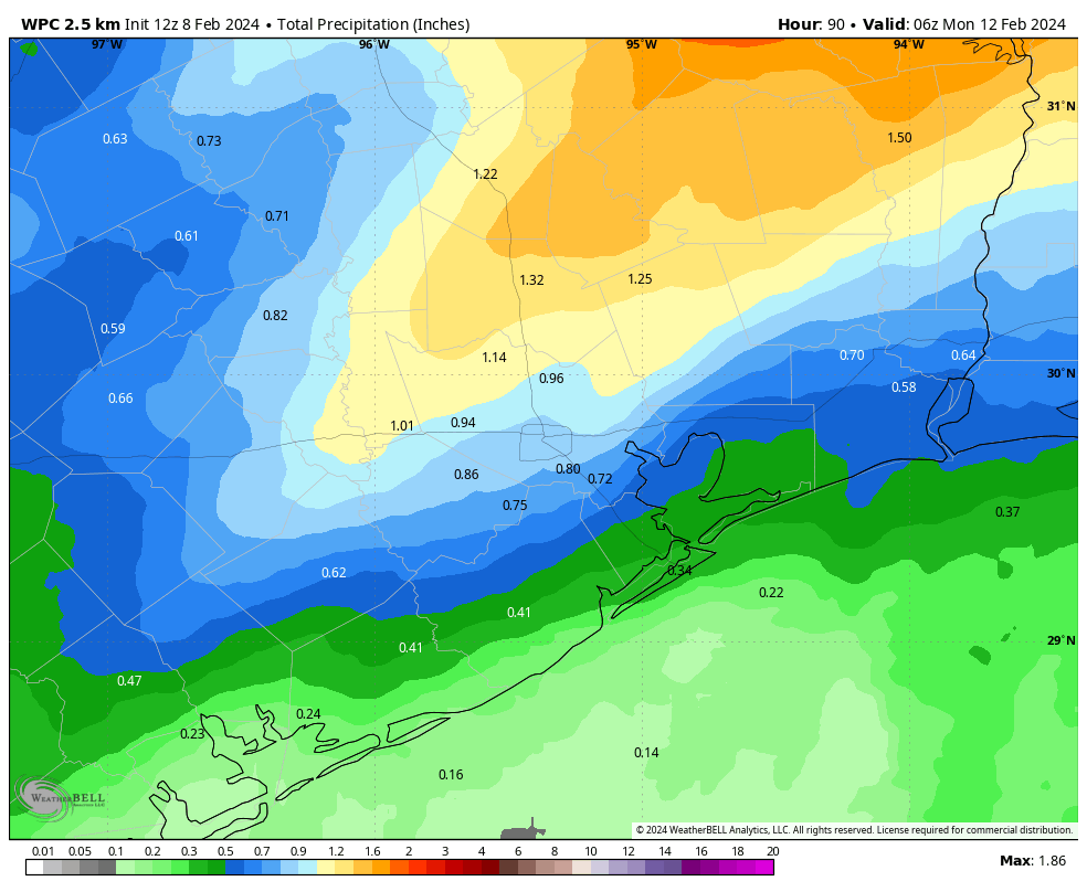
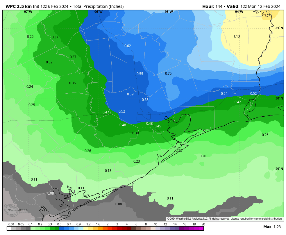
The weekend, alas, looks wetter. An increasingly perturbed atmosphere and an approaching front will produce widespread showers starting Saturday morning. Accumulations don’t look crazy. I expect most of the area to pick up between 0.25 and 1 inch of rain this weekend, with higher totals possible to the north of the metro area. This is not a flooding issue, but it will be a concern for any outdoor activities. Highs will likely be in the low 70s with cloudy skies.
NOAA rain accumulation forecast for now through Sunday. (Weather Bell)
Sunday
Sunday morning should bring more of the same before the front arrives, likely sometime during the afternoon hours. This may start to clear out our skies during the late afternoon or evening hours, ending the rain. Lows on Sunday night should drop into the 40s in Houston.
Monday and beyond
This looks to be a sunny, breezy, and colder day as we see the additional influx of northerly air. Highs may only reach the upper 50s, with northerly gusts up to 30 mph. Monday night looks to be rather chilly, with lows dropping into the upper 30s in Houston, possibly.
We’ll then see a gradual warming trend, but I’m not sure highs will climb out of the 60s. Additionally, after a couple of sunnier days, clouds return, and we could see several days of rain beginning on Thursday or Friday. I hate to make a prediction for another wet weekend, but yes, it’s possible.
At least 422* times per winter (*approximately), the question of whether “the polar vortex is coming” seems to come up. The sources are many: Rogue social mediarologists who want engagement, well-intentioned meteorologists who are just trying to explain something but the wrong takeaway gets amplified, not-well-intentioned meteorologists who can’t help themselves, and weather enthusiasts who are misinterpreting model guidance.
“An image of a map featuring an abominable snowman devouring Texas, Oklahoma, Arkansas, and Louisiana.” (ChatGPT)
We are in one of those phases now, so is the polar vortex coming for us again like it (sort of) did in January?
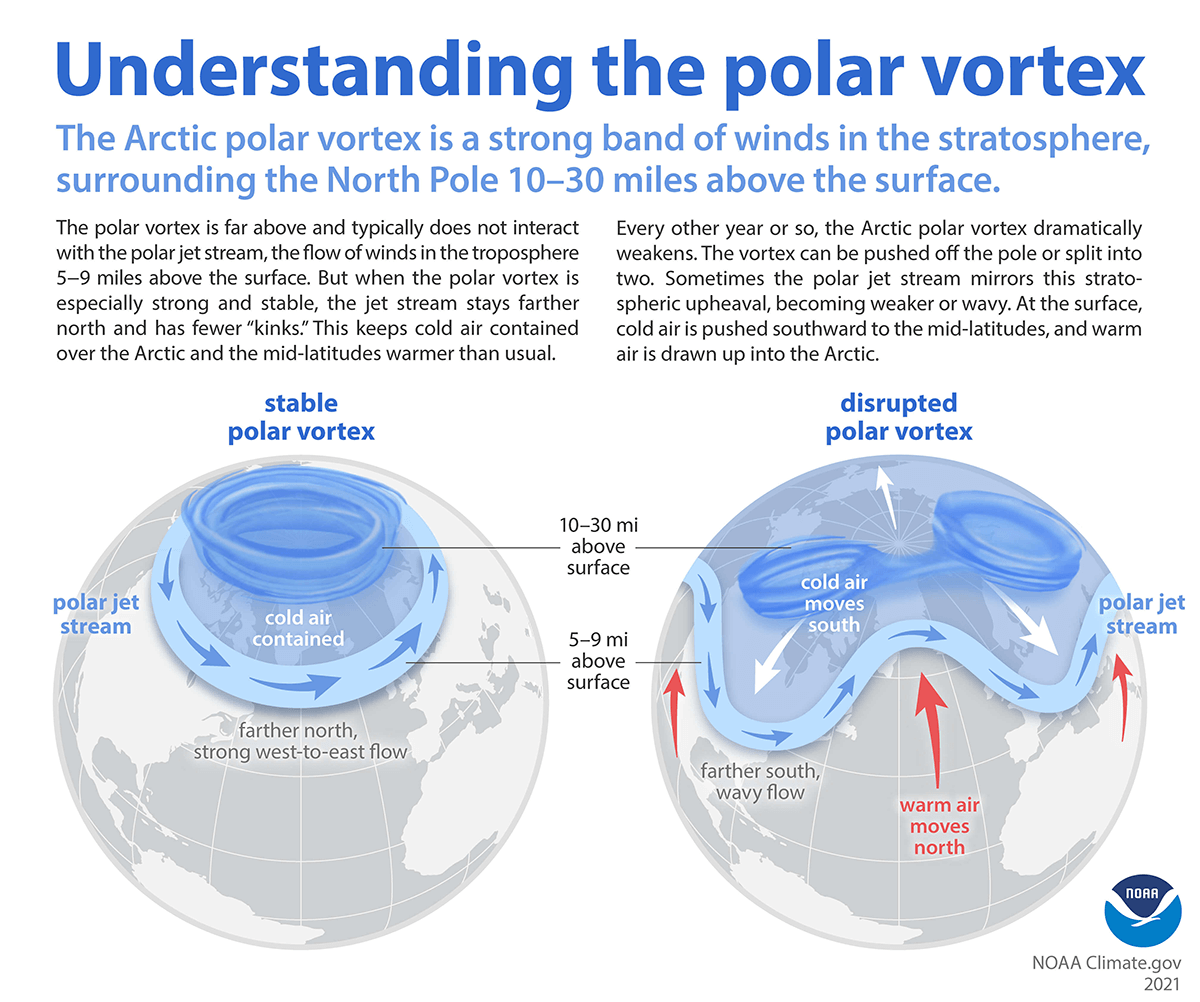
Just to get the science lesson quickly out of the way: Recall that the polar vortex is always there. It’s a permanent feature that typically sits over the North Pole, keeping the hemisphere’s coldest air in the polar region. When we refer to the “polar vortex,” what we’re really referring to is the stratospheric polar vortex, which sits miles above the North Pole but keeps the cold locked in. During the wintertime, every so often something will happen where that cold can be dislodged and dumped into the mid-latitudes leading to cold air outbreaks over the North America, Europe, or Asia. How does that happen? Periodically, you’ll get a warming event in the stratosphere that eventually works downward, first displacing or splitting the polar vortex and then leading to high latitude atmospheric blocking that warms the Arctic and sends cold south. This is what can unleash some of that more noteworthy cold air.
A visual representation of the polar vortex when it’s stable (left) and disrupted (right). (NOAA)
The process is really complicated and fairly often, stratospheric warming does not lead to significant polar vortex disruption. But almost every time there is a warming event, you now hear about it because of what I noted in the opening paragraph.
So what is happening now?
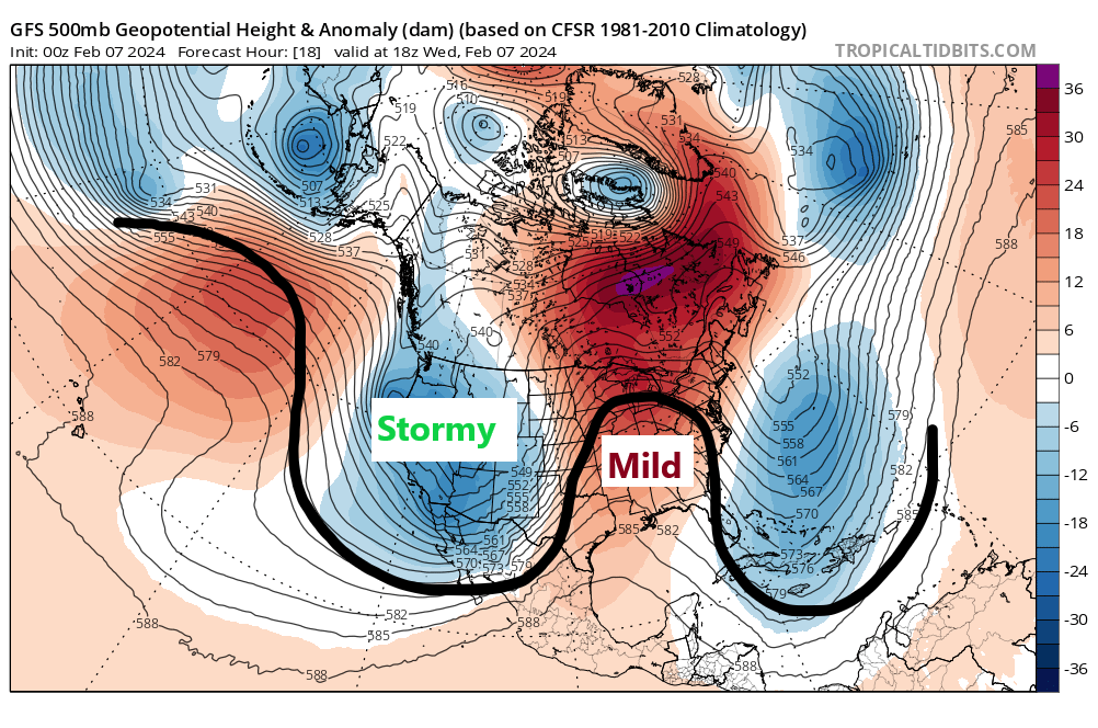
If you look at the forecast weather map today, you can see a pretty anti-winter look in the Eastern half of the country, with very mild air from Hudson Bay south to the Gulf. The West is stormy. Most of the cold is up near Alaska or Siberia and over Scandinavia.
Today’s upper air map showing the pattern at 20,000 feet with a large ridge of high pressure stretching from Hudson Bay south to the Gulf, keeping any cold in the West and any strong cold over higher latitudes. (Tropical Tidbits)
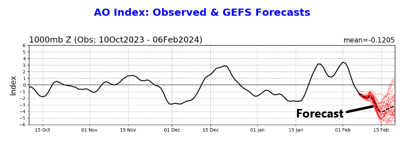
Over the next 10 days or so, this pattern is going to change rather dramatically. The ridging in place from Hudson Bay to the Gulf will weaken. The pretty neutral pattern from Alaska through the Arctic to Greenland is going to block up and warm. This will allow cold to displace back southward into lower latitudes in North America. The real serious cold is probably going to go on the other side of the globe, dumping into Russia and portions of Central Asia. One way to proxy this is to look at the Arctic Oscillation (AO). In a nutshell, the AO is a barometer for high latitude blocking over the Arctic. It’s far more complicated than just using one index to determine the fate of the weather. But in situations like this, it can help.
A forecast (and this winter’s history) of the Arctic Oscillation, projected to turn sharply negative over the next two weeks. (NOAA)
What does it tell us? When the AO is positive, it generally indicates that the Arctic will be cold. It can be assumed most of the time that the polar vortex is sort of in place, in its home over the North Pole. When the AO turns negative, it tends to mean that something has happened in the Arctic that leads to milder conditions and a weaker polar vortex, allowing cold to meander away from the North Pole and toward the populous mid-latitudes. Notice on the chart above that back in mid-January, we had a negative AO, which led to the cold outbreak. Also notice that not every negative AO produces excessive cold! We had a pretty strong bout of negative Arctic Oscillation conditions back in early December, which coincided with Houston’s most recent 80 degree day. We did turn colder after that day, but not excessively so.
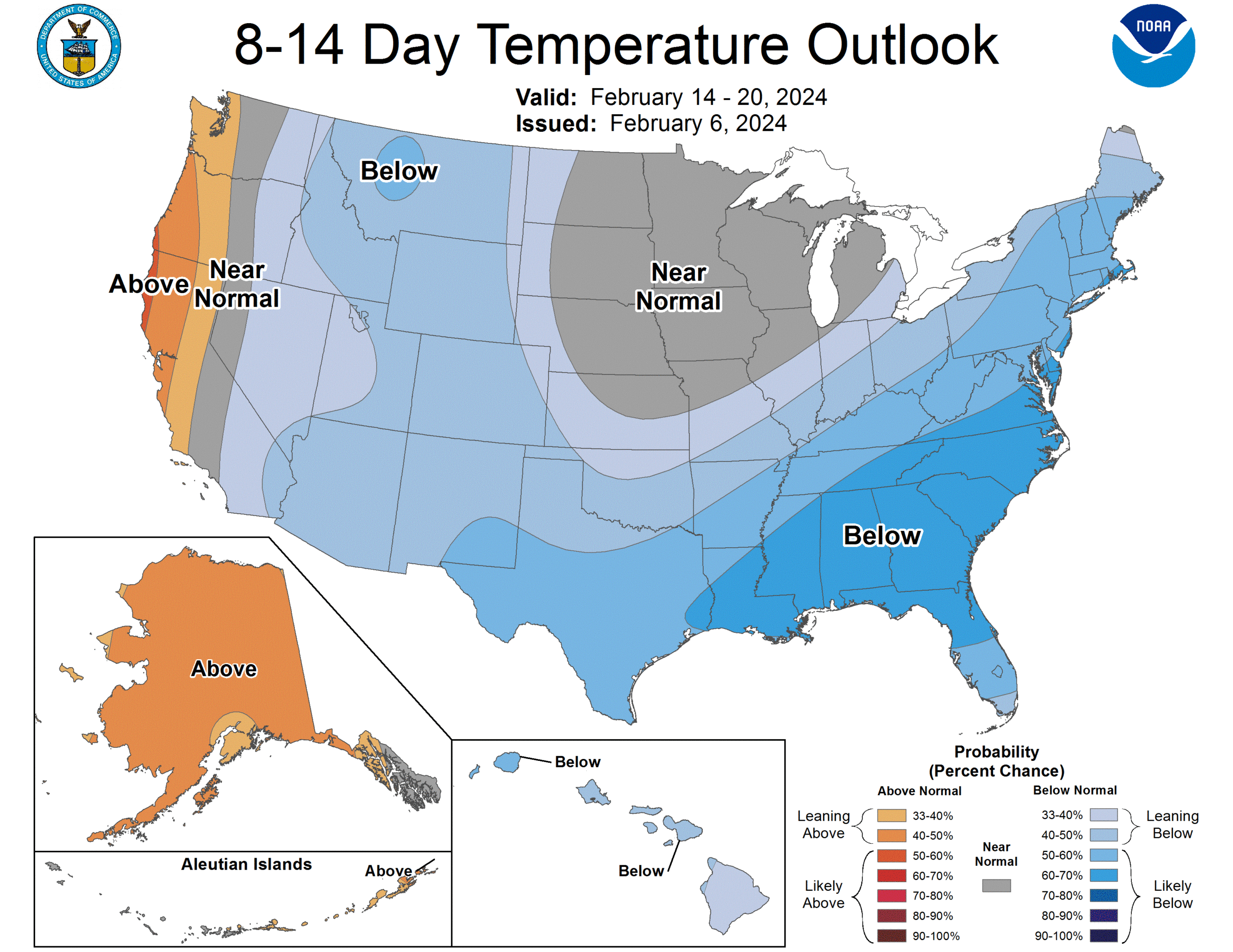
Anyway, the AO is forecast to go negative, strongly so around mid-February. This gets a lot of meteorologists’ attention, and justifiably so. It’s a strong signal for strong blocking in the polar region. And indeed, if you look at the Climate Prediction Center’s outlook for days 8 through 14, it shows colder than normal temps forecast over a broad portion of the Lower 48.
The 8 to 14 day outlook calls for moderate confidence that below normal temperatures will extend from the East Coast back across Texas and into the Rockies. (NOAA CPC)
Now, this map is plenty cold for sure. But it’s also moderate confidence. In other words, we’re not super confident in major cold right now. This meteorologist would say we are moderately confident in moderate cold. Frankly, modeling has been a little underwhelming with respect to the cold in mid-February. Some of the modeling that picked up on the ferocity of the January cold early on is not exactly doing so now, though it is forecasting cold. So at this point at least, a repeat of a January 2024-like cold outbreak in Texas seems like a longshot. But it’s going to be cold, and no, we cannot rule out a another (modest) freeze before winter ends.
This setup may be more interesting for the Southeast, particularly with a lot of moisture getting pumped in from California again. If you could perhaps combine some of that moisture into a well-timed low pressure system in the Southeast with some meaningful cold air, we could see some wintry weather in the South or Mid-Atlantic somewhere through late month.
Summary: Houston’s temperatures are in the 40s this morning, but this will be the last time until Monday as a decidedly warmer pattern sets in. It will also eventually become wetter, with some decent rain chances on Saturday and Sunday ahead of the front. Our highs will be the in the 70s before conditions turn colder on Sunday night.
Also, as a programming note, we wanted to answer a question that a lot of people have been asking about the ‘polar vortex.’ There has been a lot of chatter online about whether we’re going to experience another outbreak of Arctic air in Texas at the end of this month. Look for a post later this morning by Matt to address these concerns. The short answer is that we don’t see a particularly hard freeze coming at this time.
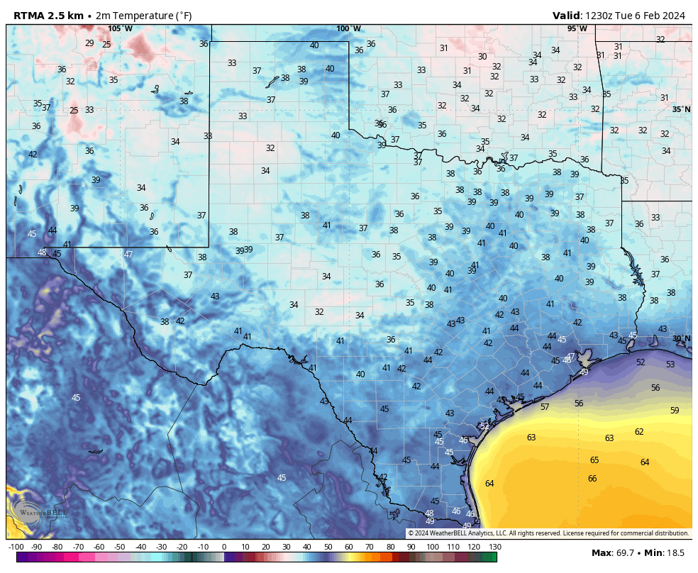
Most of Houston is in the 40s this morning, but this will be the last time until at least next Monday. (Weather Bell)
Wednesday
Temperatures this morning are generally in the 40s, with the usual few outliers. Conroe is in the upper 30s, and it looks like Galveston will remain at about 50 degrees. However, with winds from the southeast we’re already seeing the beginnings of an onshore flow that will bring warmth and humidity into the region. Those winds will turn fairly gusty later today, blowing at times up to 25 or 30 mph.
Skies should be clear this morning, but with increasing atmospheric moisture I think we’ll see partly to mostly cloudy skies this afternoon. We’ll be saying goodbye to the sunshine for awhile. Expect highs in the low 70s, with temperatures on Wednesday night only dropping into the low 60s. Some very light showers may be possible after midnight.
Thursday
This will be a gray and warmish day, with highs in the low 70s. Winds will be from the south, perhaps gusting up to about 20 mph. Some light rain showers will be possible, but any accumulations are likely to be on the order of a few hundredths of an inch. I’d put chances at about 20 or 30 percent, so pretty scattered. Thursday night will be cloudy and mild, in the low- to mid-60s.
Friday
This will be another day a lot like Thursday—gray and warm with low chance of light rain.
Saturday
As the atmosphere turns more turbulent this weekend we’re likely to see an uptick in rain chances. You probably have a greater than 50 percent chance of showers, especially for areas north of Interstate 10, and to the northeast of Houston, including locations such as Kingwood. In terms of accumulations most areas will see a few tenths of an inch of rain, but a few areas may see higher totals. Temperatures, otherwise, will be in the low 70s.
NOAA rain accumulation forecast for now through Sunday. (Weather Bell)
Sunday
This day also looks fairly warm, in the low 70s. Our weather, ultimately, will depend on the rate at which the front slogs through the area. I don’t have great confidence in those details yet, but my sense is that we’ll once again see fairly widespread showers before some cooler air starts to arrive Sunday evening or overnight. Lows on Sunday night may drop to about 50 degrees. We’ll see.
Next week
We’ll see clear skies and colder weather to start next week, with highs in the 60s and lows in the 40s through Wednesday. At this point Tuesday morning looks like the coldest day, with lows possibly dropping into the upper 30s. Some rain chances return later next week, and it’s not clear to me whether we’re going to warm above the 60s. So if 70s and humidity are your jam, enjoy the next few days before somewhat colder air returns.
Summary: Houston gets about 10 or 15 days of A+ weather a year when there is absolutely nothing to complain about. Today, in my opinion, is one of those days. We’ll still see some sunshine on Wednesday before we transition to cloudier and muggier weather. The weekend should see the return of rain showers, although not something we’re concerned about in the sense of flooding.
This early February morning is starting out chilly across much of the state. (Weather Bell)
Tuesday
For me, at least, it doesn’t get any better than this. After a chilly start, today will bring sunny skies, a high temperature of around 70 degrees, dry air, and a very light northerly wind. It won’t last in Houston. It never does. In fact we’ll see the return of a southeasterly flow tonight, which will spell the beginning of the end of our dry air. Lows will still drop into the upper 40s before a warming trend begins.
Wednesday
With the southerly flow in place, we’ll start to see the formation of clouds on Wednesday. I think there is a chance that the morning skies will be reasonably clear, but at some point tomorrow we’re going to flip the switch to mostly cloudy skies. Highs will get into the low 70s, and lows on Wednesday night will only drop to around 60 degrees. Southeast winds may gust to around 20 mph, helping to usher drier air out of the region.
Thursday and Friday
These will be a pair of mostly cloudy days, with somewhat humid air, and highs in the mid-70s. Winds will be persistently from the south, but only at 10 to 15 mph. The only real question for each day is whether we’ll see any rain. I think there’s about a 20 percent chance of very light precipitation each day.
Saturday and Sunday
The weekend’s weather will be a little more dynamic, unfortunately. For those of you a tad upset about nice weekdays and rainy weekends, I’m afraid I’ve got some bad news for you. Saturday and Sunday will both see a healthy chance of light to moderate rain showers before a front arrives sometime on Sunday to clear things out. We’re looking at highs in the mid-70s on Saturday and, depending on the timing of the front Sunday, upper 60s to 70s on Sunday.
NOAA rain accumulation forecast for now through Sunday. (Weather Bell)
The weekend doesn’t look to be a total washout, but I think there’s probably a 50 percent chance of showers each day, with accumulations of 0.25 to 0.75 inches for most, and a risk of higher isolated totals. So we don’t have any real flooding concerns, but these showers may definitely put a damper on outdoor activities. Lows on Sunday night will probably drop into the upper 40s.
Next week
The first half of next week should bring at least partly to mostly sunny skies, and we’ll see highs in the 60s with lows in the 40s. As the southerly flow returns mid-week Houston will return to warmer conditions, and there’s a signal for some rainfall by next Thursday or Friday. But at that point the crystal ball is starting to get pretty foggy.
Anyway, have a great day everyone. I hope you can steal some time outside. Also, I was just kidding about finding something to complain about. I have no doubt on y’all’s ability there.