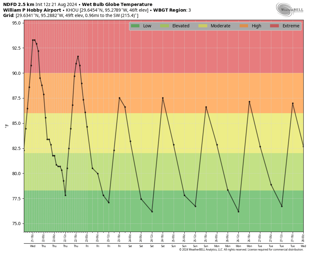
In brief: After a week straight of 100s, we’re now on the downtrend, albeit slowly. Look for increasing rain chances heading toward next week and less hot (but not quite cool) weather. Each day will provide us at least a non-zero chance for a cooling downpour or thunderstorm.
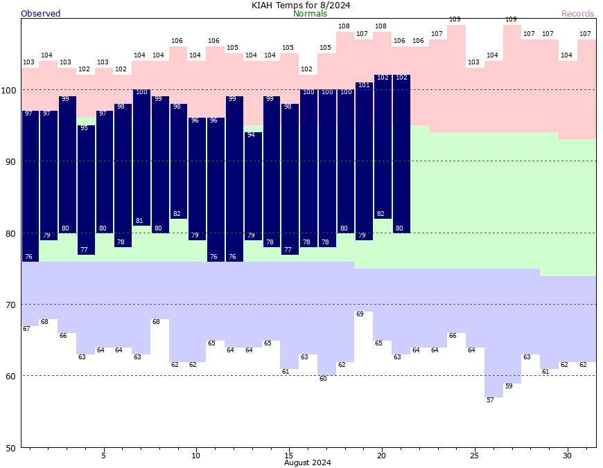
Yesterday was Houston’s seventh consecutive 100 degree day. And while we may make light of this summer’s heat after last summer, did you know that this was only the 14th time since the 1890s that Houston has strung together a week straight of 100 degree weather? It’s true. Of the 14 instances of a week of 100s, eight have occurred since the year 2000. Only one occurred prior to 1962. The average temperature over the last week has been 90.2°, which only ranks tied for 94th hottest seven-day stretch all-time. So there you go. The good news is that the worst is over, and we can introduce the word “rain” again a little more frequently.
Today
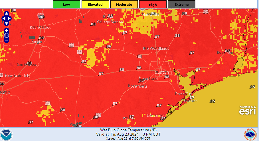
We have some storms this morning drifting south and west out of Fort Bend County and into Matagorda County. So be on the lookout for that. Otherwise, we may get through today without a heat advisory.
Mostly moderate to high and not much extreme heat levels are to be found around the Houston area this afternoon thanks to a slightly cooler air mass and some scattered showers. (NOAA)
We’ve got a slightly cooler air mass, slightly more humidity, and slightly higher rain chances today than we had yesterday. Some people did see rain and hear thunder on Thursday, including Sugar Land and Missouri City, as well as southeastern Brazoria County. Today, a few more of us should see raindrops besides those seeing them this morning. Expect scattered activity to pop up later, but rain chances are only around 20 percent. Where it rains later, look for temps in the 90s falling into the 70s or 80s for a time, then heating back up after it stops. Where it doesn’t rain, look for mid to upper-90s.
Weekend
The forecast for this weekend is straightforward but also tricky. In general, it will be sun, clouds, 90s, and a chance of a shower or storm with the sea breeze each afternoon. However, based on the model guidance I’m seeing this morning, I would lean toward Saturday being a quieter day overall and Sunday being more active, with a greater coverage of showers and storms. The European model and its AI model seem to support this idea, but I would have the umbrella and a plan to scoot inside on either weekend day.
Next week
We get to watch two things next week. The first will be this disturbance in the Gulf that pivots onshore on Sunday night and Monday. It will not develop into a tropical system, but it will continue rain chances into Monday, Tuesday, and Wednesday for us. The second item may be a piece of another tropical wave over Hispaniola today that moves into the Gulf next week and adds another little bump in moisture levels toward next weekend. No development is expected. That said, it may peel off to our east into Louisiana before arriving.
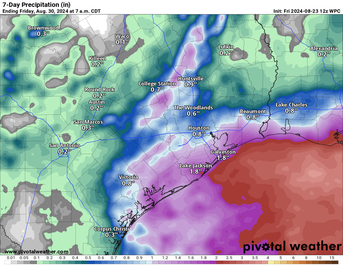
Rain totals over the next week will be most concentrated and highest south of I-10 and along the coast, while most areas should see at least some rain. (Pivotal Weather)
We are looking at some modest rainfall overall, especially south of I-10. Locally heavier rain is likely in a few spots that are TBD right now. Basically, there will be a chance of rain every day next week, with some day to day variation in coverage and specific locations of highest rain chances. This should not be a major rain setup for Houston, but it will certainly be a change from this week. Highs will be in the low or mid-90s, so not exactly cool but with periodic rains and more clouds, it will be more tolerable overall.
The tropics remain quiet. More on that at The Eyewall later this morning.
In brief: Thursday is still going to feel very hot across Houston, but by this weekend we’ll return to temperatures in the mid-90s with a slight chance of rain. Next week we’re going to see partly cloudy days, with highs in the low- to mid-90s, and widespread showers. And then, all of a sudden, we’re into September.
Past peak summer?
Golly, I sure hate to write that we’re probably done with the worst of summer, because one never wants to tempt Mother Nature. However, we just experienced a stretch of six 100-degree days (we may add one more today, although I wouldn’t bet on that). High temperatures peaked on Tuesday and Wednesday, reaching 102 degrees at Bush Intercontinental Airport. It’s going to be difficult to top that.
The last week has not been any fun, in terms of hot temperatures. (National Weather Service)
We know for sure that Houston highs are on a clear down slope for the rest of this month. Although we certainly can hit 100 degrees in September, at this point the odds are fairly low that we see another sustained stretch of brutally hot weather. I’m not ready to say we’re done with triple digits, but I really do believe we’re past the worst of the summer of 2024 in terms of heat.
Thursday
Today is still going to be really hot, of course. High temperatures will reach the upper 90s today, and some inland locations may hit 100 degrees. But we should be slightly cooler than on Wednesday. There is, perhaps, a 10 percent chance of showers this afternoon. Winds will be light, increasing to 5 to 10 mph from the southeast this afternoon. Lows tonight will drop to around 80 degrees.
Friday
Skies will again be mostly sunny, but for most of Houston highs will likely peak in the mid- to upper-90s. Some scattered showers will also be possible starting in the morning hours, and persisting into the afternoon with daytime heating. Overall rain chances will be about 20 degrees.
Saturday and Sunday
Overall skies should be mostly sunny this weekend, but there likely will be a few clouds during the afternoon. Most locations should see highs in the vicinity of the mid-90s. Rain chances will be on the order of 20 to 30 percent daily, mostly driven by the sea breeze. Lows will remain warm, but should start dropping into the upper 70s.
We’ll have one more very hot day before temperatures start to feel more comfortable. (Weather Bell)
Next week
As high pressure backs off further, we’ll see our region open up to moisture from the Gulf of Mexico next week. This will lead to healthy, daily rain chances on the order of 50 percent. Generally, next week, we can expect high temperatures in the low- to mid-90s, with partly cloudy skies, and periodic passing showers with embedded downpours. The likelihood of rain will be greater near the coast, but everyone should have a chance of seeing some showers. We will likely remain in this pattern through most of next week, and possibly into the weekend.
Tropics
The Atlantic tropics are quiet. In case you missed it, we published a long post from Matt yesterday on why that is, and how long it will last.
In brief: Has the 2024 Atlantic hurricane season been a bust? In short, no. However, we are enjoying a rare period of quietude in late August, and with temperatures incredibly warm in the Gulf of Mexico at present we’ll take it. To get a better idea of what’s going on, and to understand why September is likely to be active, we are sharing this post which was originally published by The Eyewall this morning.
Forecasts called for an incredibly active season
Coming into this hurricane season, there were breathless forecasts calling for anywhere from 20 to even 30 named storms from some folks. Government forecasts were more conservative but even they were the most active we’ve ever seen from NOAA. Colorado State, too. So, as we sit here on August 21st with next to nothing showing up in modeling for the next 7 to 10 days, it’s reasonable for the general public to ask questions about those forecasts.
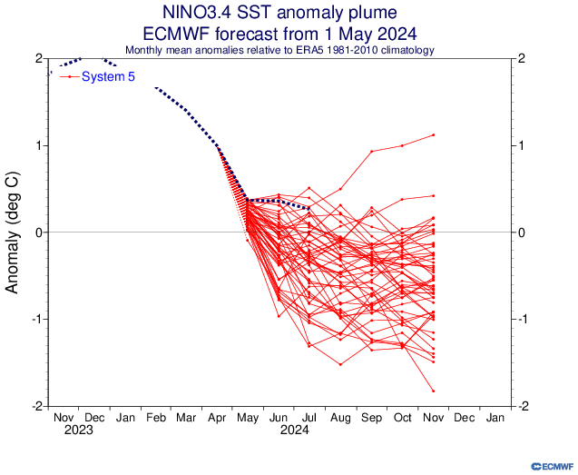
One of our potential fail modes was if La Niña developed too slowly. Indeed, the pace of the La Niña development this season, while uneven, has generally lagged the strongest projections. At least officially. Here’s a look at the May 1st European model ensemble outlook for the ENSO 3.4 region, the box of temperatures we look at to basically designate La Niña or El Niño.
The spring forecasts for La Niña have (to this point) turned out a little too aggressive. But directionally, they’ve been fairly correct. (ECMWF)
We should begin closing in on an official La Niña designation in the next month or two, but we aren’t quite there yet. Keep in mind, this is by no means a perfect representation of things, and sometimes the atmosphere can behave more Niña-like even if we aren’t officially there yet. But this has not developed as aggressively as some modeling showed in developing in spring.
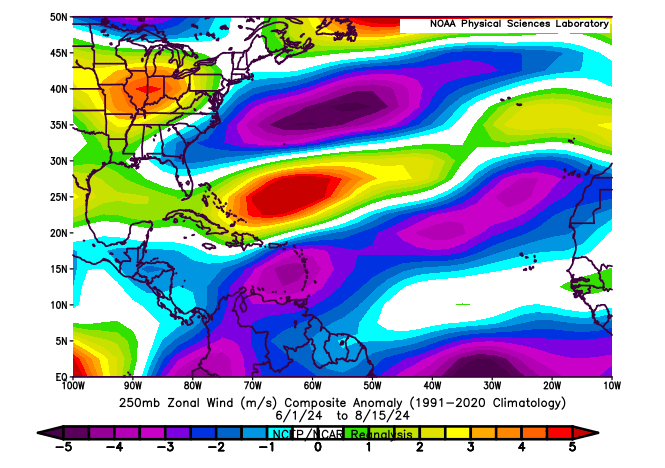
So, at a very, very distant level, perhaps that has something to do with it. Michael Lowry, in his excellent daily newsletter pointed out yesterday that wind shear has become almost too extremely reversed this month. Typically, during a La Niña, there is more of an easterly component from the wind that counteracts or reduces the usual west to east winds that can cause shear in the Atlantic, detrimental to hurricane development. In a twist of fate, there’s so much of an easterly component to the upper level winds this year that it’s actually causing easterly shear. Otherwise, we might be a good bit busier at the moment. If you look at the basin as a whole since June 1st, winds have been generally lighter than usual in the Caribbean and much of the Atlantic and a bit stronger than usual in the southwest Atlantic and in the Gulf.
Upper-level winds have been generally below average this summer in some key tropical development areas. As such, we’ve accumulated some bang for our buck this season so far. (NOAA PSL)
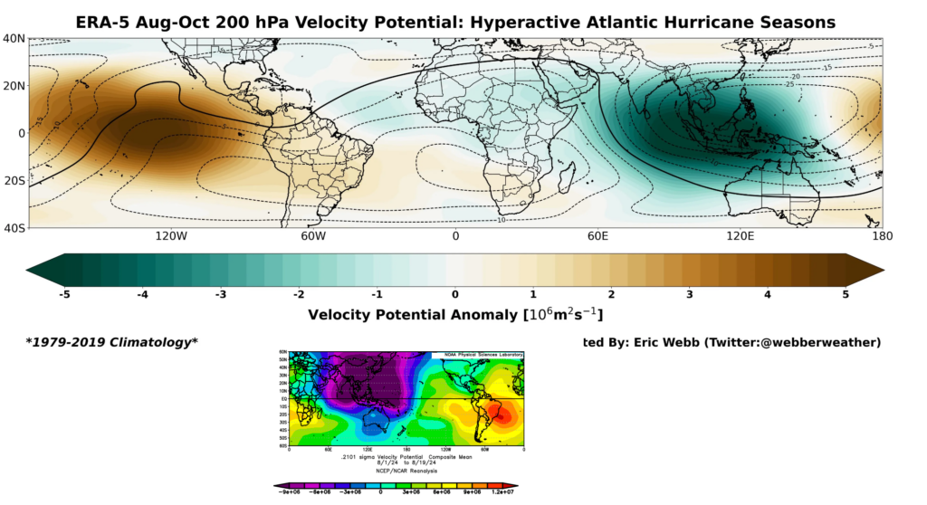
Let’s dig a little deeper. One thing that’s legitimately fascinating to me right now is what’s happening in terms of upper level background support in the atmosphere. Using a variable known as velocity potential, we can see that in historically active hurricane seasons, you would expect to see a significant area of rising air in the Indian Ocean, bleeding a bit into Africa (green on the top map below). Opposite to that, there would be a significant area of sinking air in the Eastern Pacific Ocean (brown colors below). Why is this important? In order to generate an active outbreak of storms in the Atlantic, you need disturbances tracking across Africa, which tend to get supported by rising air over and just east of there. You also prefer to see the Pacific undergoing sinking air, as a way to keep it from ‘robbing’ the favorable conditions for storminess. Sinking air suppresses thunderstorm development and tends to dry out the air a bit.
So what’s going on right now? So far this August, we’ve actually *had* what we would expect from a hyperactive season in the Indian Ocean. Click to enlarge the image below.
A comparison of velocity potential in hyperactive seasons (top) vs so far this August (bottom). While we have what we’d expect for a period of high activity, something is out of phase inhibiting things. (Eric Webb/NOAA)
We have a ton of rising air in the Indian Ocean this month (purple & blue on the bottom map above). We have that extending into Africa. This is what you’d expect for a busy season. Where it differs, however is exactly where the sinking air (red/orange in the bottom panel above) is located. In a typical hyperactive season, this is focused over the Eastern Pacific. This year, it’s focused on the eastern side of South America. This is Matt speculating wildly here, but: I suspect that we’re seeing the right ingredients in place, but I think we are seeing them out of phase. The rising air in the Indian Ocean extends deeper into the Pacific, and there is more of a neutral Eastern Pacific signal right now. This is helping boost activity in the Pacific.
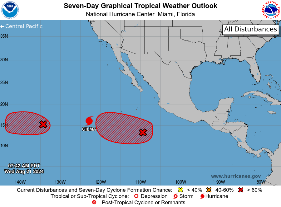
Today’s 7 day outlook in the Pacific includes Hurricane Gilma and two other disturbances that are likely to organize. (NOAA NHC)
What is in the west will come east
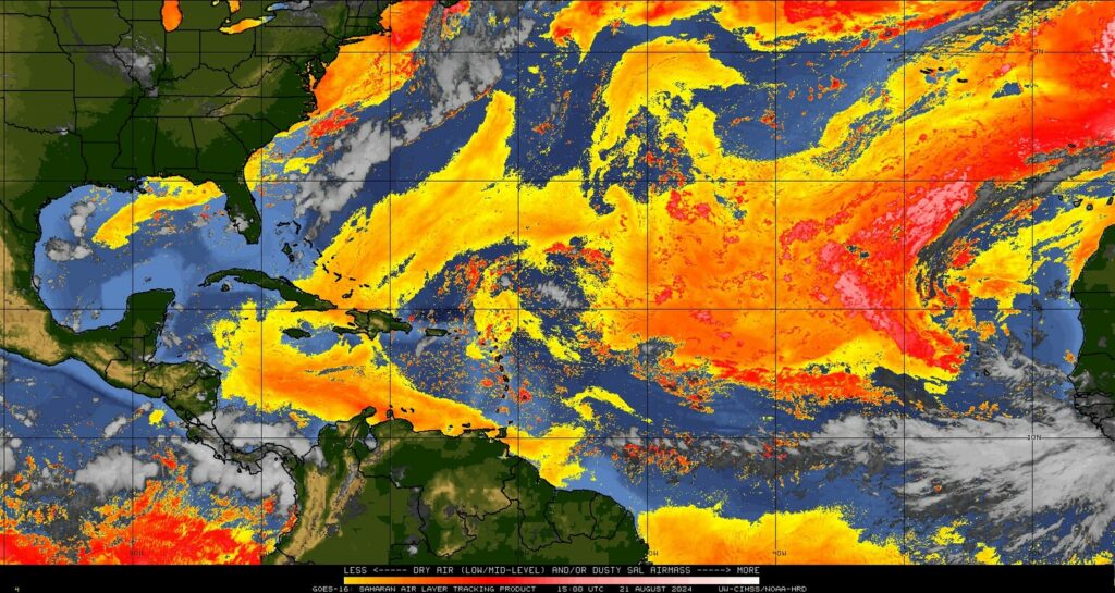
The problem with the tropics is that support like this generally moves from west to east, and eventually this will change. So the quiet now may change in a very, very quick way come September when this (presumably) shifts. For now, the Atlantic is still seeing rampant dust and a slightly displaced intertropical convergence zone (ITCZ) which is sending disturbances off Africa too far north and into dust. So they die off earlier. This too will change.
Widespread Saharan dust (pink, red, orange) extends across much of the Atlantic, and as disturbances are coming off farther north than usual, they’re hitting the dust head on. (University of Wisconsin CIMSS)
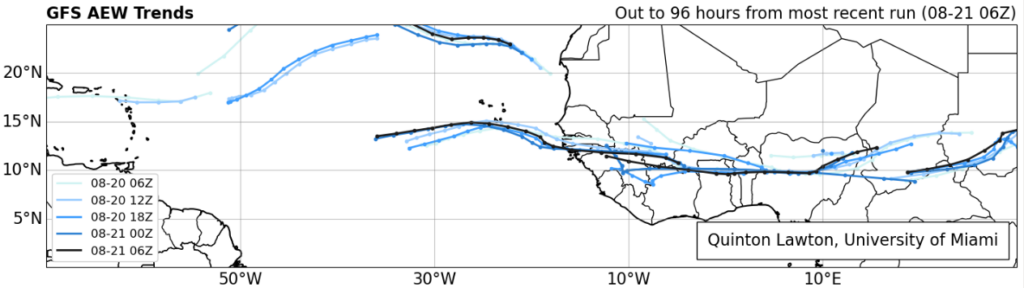
In fact, if you look at the forecast of African Easterly Waves (AEWs) from the latest GFS model, you can see this southward shift approaching heading into the next week or two. The waves lined up over Africa are about 5 to 10 degrees farther south in latitude about 4 days from now, which means they will emerge farther south and in more of a traditional area less exposed to Saharan dust in late August and September.
Tropical waves are going to begin emerging off Africa farther south than they have been recently, which should ultimately lead to a boost in activity heading into September. (Quinton Lawton, University of Miami)
So, yes, things are almost certainly going to pick up soon.
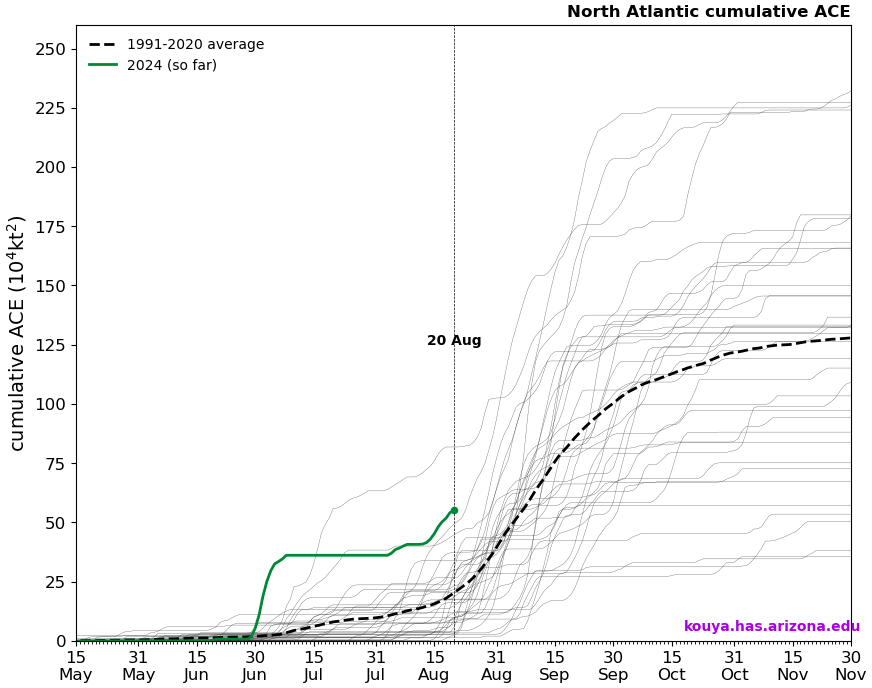
Despite perception, this season’s current accumulated cyclone energy is running nearly 3 times higher than usual! We’ve amassed as much ACE so far this season as we’d typically see by the peak day of hurricane season (September 10th). We’ve done this on the backs of only five storms so far, three of which have been hurricanes, and one of which (Beryl) smashed early season records in the Caribbean and Atlantic.
Accumulated cyclone energy (ACE) this season has been historically high despite the perceived slow start to the season. (Kim Wood/University of Arizona)
So despite the perception that this season has been slow to start, it actually has not been. In fact, 2024 is in rarefied air in terms of ACE to date. This perception might have to do with storm inflation, or the idea that we are naming more storms today than we did, say, 20 or 30 years ago. In 2020, basically the benchmark for recent historically active seasons, today marked the formation date for Hurricane Laura, the 12th named storm of the season. Here we are in 2024 sitting at five, and it’s no wonder the perception is skewed. Despite having more than twice as many storms to this point in 2020, we only had half the ACE (26 vs. 55 this year). 2020 kept churning out mostly sloppy storms until Laura, and then things got nasty. We’ve had three legitimate hurricanes this year and only about one “throwaway” storm (Chris). The takeaway message here is that: We can make up ground in September very, very fast. Very fast.
In summary
So, no, this season’s extremely active hurricane seasons have not been a bust so far, and they probably won’t end up being a bust overall. We’ve had a “bang for our buck” season so far with quality storms over quantity as, say, in 2020. And while we are in a lull now, the setup is probably going to change in 7 to 10 days to allow things to crank up in September. Never call it a bust. If it is one, we can discuss why in November. For now, use this quiet time to review your hurricane preparedness plans and supply kits. And stay tuned here for the latest.
In brief: We’re nearing the end of peak summer in Houston, but today is still going to be excessively hot with temperatures in the low 100s. By Thursday we’ll see the start of a slow cooling trend, which will eventually bring us cloudier skies and improved rain chances by early next week.
Wednesday
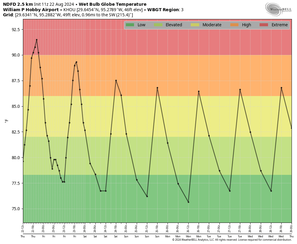
High temperatures on Tuesday officially reached 102 degrees at Bush Intercontinental Airport, the warmest temperature recorded so far this year. Conditions today will be similar, with mostly sunny skies and very hot temperatures. Winds will be light, from the southeast. Lows tonight will provide scant relief, likely falling only to about 80 degrees. The good news is that today will probably be the hottest day for the rest of 2024. I cannot guarantee that, of course. But probably.
One more day of excessive heat. (Weather Bell)
Thursday
High pressure that’s been situated over West Texas will finally start to back away, and this will slowly start to moderate our conditions. It won’t happen right away, of course, as highs on Thursday could still reach 100 degrees in some locations. But it’s a start. I think there also will be a chance of some isolated showers and thunderstorms, although overall chances will remain quite low, on the order of maybe 10 percent.
Friday
Expect sunny and hot weather, with highs in the upper 90s. Rain chances will be about 20 percent, with isolated to scattered showers possible along the sea breeze.
Saturday and Sunday
Highs this weekend will be in the mid- to upper-90s and precise temperatures at your location will depend on the extent of cloud cover and whether any showers pop up during the afternoon hours. The bottom line is that it will be hot, but not excessively so. Low temperatures should fall back into the upper 70s.
More seasonable weather returns by Friday for late August, in Houston. (Weather Bell)
Next week
As high pressure moves further away, our weather will become increasingly influenced by the Gulf of Mexico. This means we should see partly cloudy days next week, with high temperatures likely in the vicinity of the mid-90s. Daily rain chances will increase throughout the week, starting in perhaps the 40 percent range on Monday, and rising to likely by the second half of the week. We’re not looking at a total washout by any means, but hopefully we’ll see some cooling rains that bring needed moisture to our soils. As I was discussing with a friend yesterday, it really does not get a whole lot better than that in Houston, in August.
Tropics
Nothing is happening. Later this morning we’ll have a post from Matt to explain why that is—during a season which seasonal hurricane forecasters predicted a hyperactive year in the Atlantic.