Houston in the midst of its hottest stretch of 2024, but modest relief is on the way

In brief: Temperatures in our region will likely reach their highest levels of the year this week, with most locations pushing into the low-100s. However, this is probably the worst of it for the year, with somewhat cooler weather arriving by this weekend, and healthy rain chances next week.

Peak heating

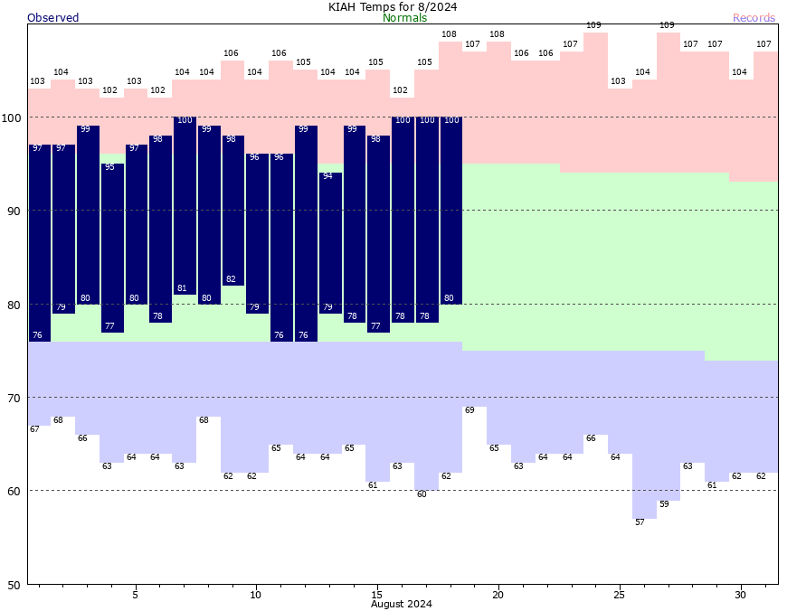
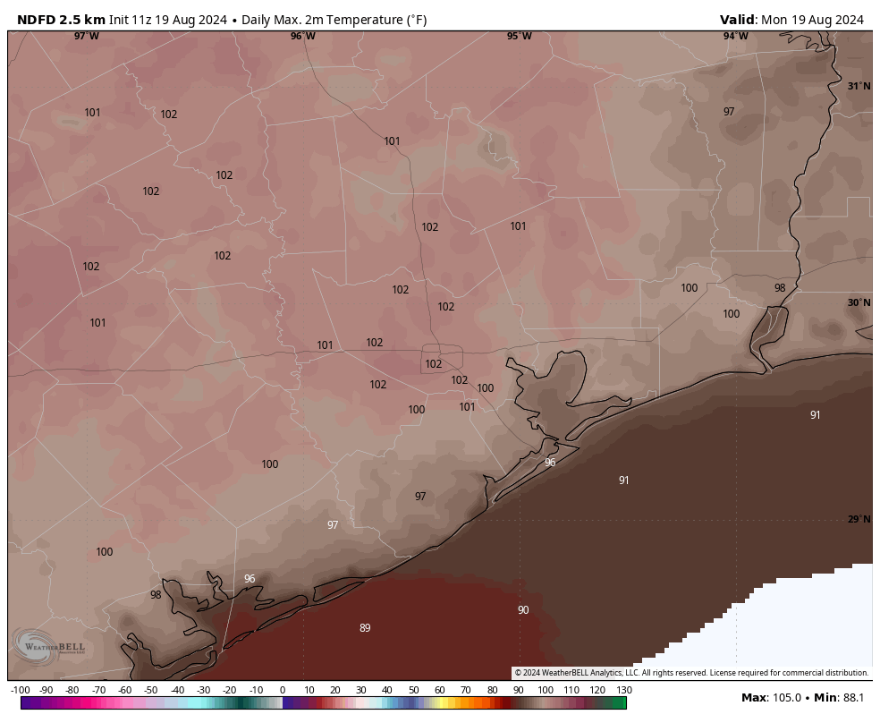
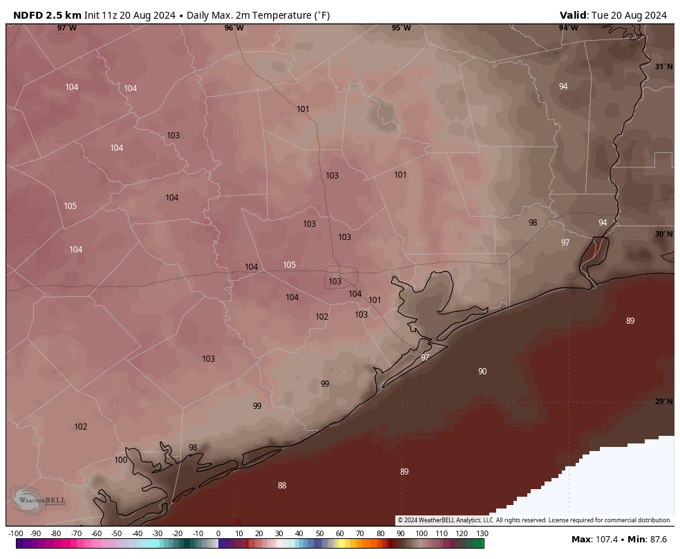
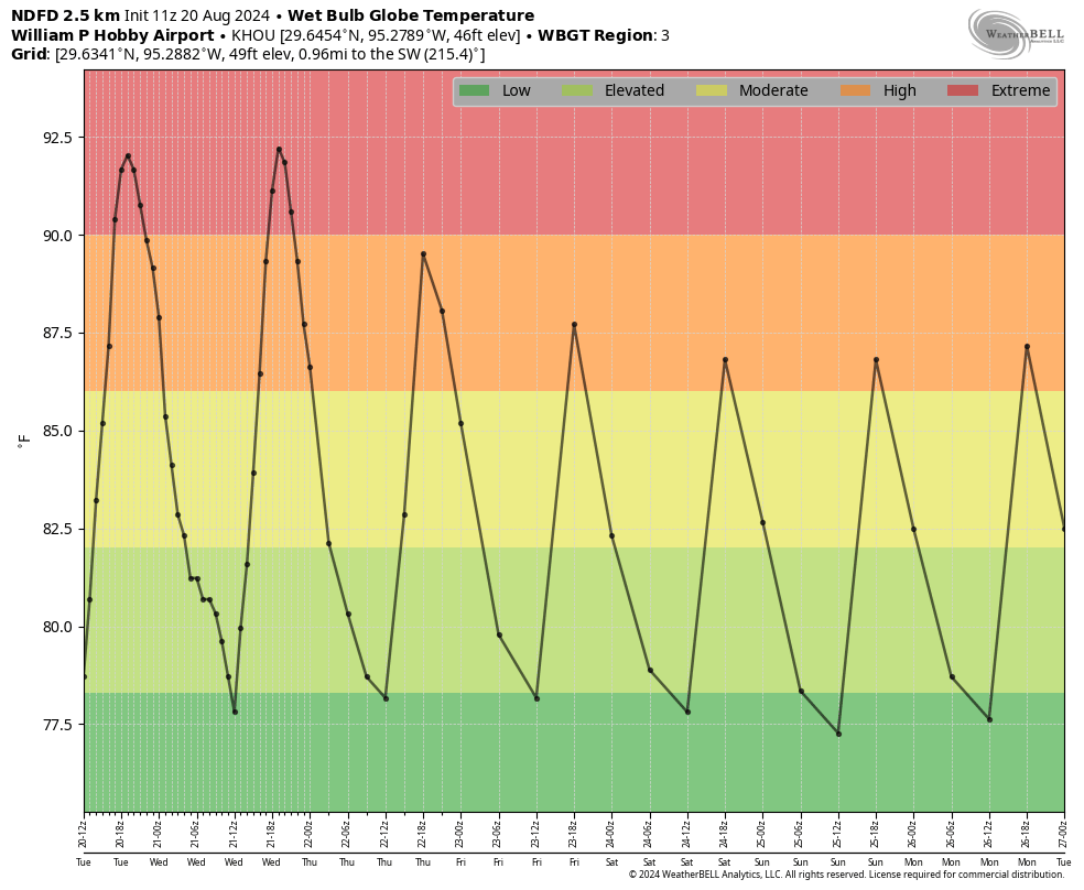
Our current stretch of weather will almost certainly be the hottest period of 2024. Houston recorded its hottest day of the year on Monday, 101 degrees, and it was the fourth day of triple digit temperatures in a row. Today could well even be a few degrees hotter, and Wednesday is likely to reach above 100 degrees as well. However, after this stretch we should slowly start to cool down and reach the mid-90s by the weekend. Better rain chances and possibly even cooler temperatures are on the horizon for next week, which gets us into September.

Tuesday’s high temperatures will be rather unpleasant. (Weather Bell)

Tuesday

Today will be extremely hot. Most of the Houston region will see daily high temperatures in the low 100s, with mostly sunny skies and only light winds from the west. This probably will be the hottest day Houston experiences this year as we feel the influence of high pressure and sinking air. Low temperatures on Tuesday night will only drop into the low 80s.

Wednesday

This will be another very hot day, with sunny skies. Temperatures, however, may be 1 to 2 degrees cooler than Tuesday.

Thursday and Friday

As high pressure backs off, our temperatures will ease slightly. Most of the region is still likely to see highs in the upper 90s to 100 degrees, however. Skies remain mostly sunny with rain chances near nil.

Saturday and Sunday

As high pressure backs off further, we should start to see some partly cloudy skies this weekend, and that will assist the downward trend in temperatures. It’s still going to be hot, mind you, but highs will peak in the mid-90s for most locations, with nights dropping into the upper 70s, probably. Rain chances will also return this weekend although they’ll start out on the low side, perhaps on the order of 20 to 30 percent daily.
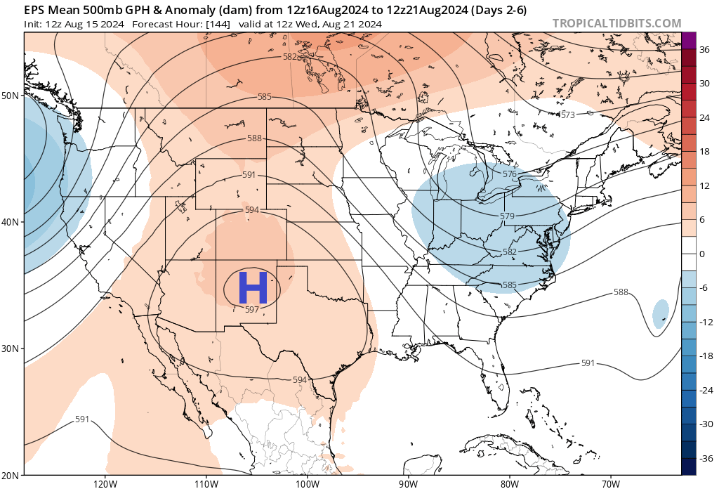
We’ve got a couple of extremely hot days before relief arrives this weekend. (Weather Bell)

Next week

In the absence of high pressure, our region will lie exposed to the influence of Gulf moisture. This is likely to produce at least partly cloudy skies next week, and daily rain chances. I think highs will be in the low- to mid-90s, and much of the area is likely to pick up between 0.5 and 2 inches of rain—although I am getting deep into the realms of speculation with that prediction. The bottom line is that our overall pattern should change from what has otherwise been a very hot, sunny, and rain-free August.

It will be brutally hot for a few days, but a pattern change is on the horizon

In brief: Houston is likely to see its hottest weather of the year over the next couple of days. But after this, we should slowly start to cool down. Moreover, after a very dry month of August, rain chances should start to noticeably improve beginning this weekend or early next week.

August heat

We’re a little more than half way through August, and so far this month we’ve experienced four 100-degree days, and the lowest daytime high has been 94 degrees. Skies have been almost universally sunny, and many areas have experienced no rain. This is how it often goes in August, and our high temperatures for the next couple of days could be even hotter—many inland locations will reach the low 100s today and Tuesday.

It’s been a very hot start to the month of August. (National Weather Service)

However, over the course of this week we’ll see high pressure that has been anchored over West Texas begin to slide northward, and this will begin to ease the peak-summertime weather in Houston. High temperatures by this weekend should fall back into the mid-90s, and rain chances will start to improve this weekend or into next week. The details of all this are still somewhat in flux, but it’s likely that the end of August will feel different than the rest of the month.

Monday and Tuesday

There’s no way to sugarcoat this part of the forecast. With high pressure in place, today will see excessive heat with high temperatures in the low 100s for much of the region. These may well be the hottest days of this year, so please take heat precautions during the middle of the day. Skies will be mostly sunny with very light winds. There will be about a 10 percent chance of rain, as a few isolated showers may develop along the sea breeze. But mostly, these will be very, very hot days. Overnight lows will only drop to around 80 degrees.

High temperatures on Monday will be brutally hot. (Weather Bell)

Wednesday, Thursday, and Friday

These will also be hot days, but we may trend downward just a bit from the low 100s on Wednesday to upper 90s by Friday. Each day will also see a slightly better chance of rain, perhaps 20 percent, as there’s a little bit more activity due to increased moisture levels. Still, the overall pattern will be one of heat and sunshine.

Saturday, Sunday, and beyond

As high pressure eases off, I think most of the Houston metro area will see high temperatures dip back into the mid-90s this weekend. At the same time we may start to see the influence of low pressure from the Gulf of Mexico. I don’t know if rain chances will improve a whole lot this weekend, but at some point in the next week or 10 days, we’re likely to start seeing much better daily odds for rainfall. So for Saturday and Sunday I’ll say there probably will be some scattered showers and thunderstorms, with better chances for more coverage into next week.

Ernesto is headed to the exits. (National Hurricane Center)

Tropics

Hurricane Ernesto is in the northern Atlantic, and will pass not all that far south of Newfoundland today and tonight before it accelerates eastward across the open Atlantic. Beyond Ernesto, the tropics look to remain quiet for at least the next week.

Houston’s heat rolls on, so we look into some of the differences this summer and how long the heat may last

In brief: Heat and humidity will be a bit worse than usual for August this weekend, and although things ease up just a bit next week, we will remain hot and mostly dry. There may be a shift toward better rain chances next weekend.

Today through next week

Sunny, hot, humid. Highs in the mid-90s to near 100 degrees. Maybe a rain chance. And you know what? I congratulate my neighbors that have seen showers this week and may luckily see showers into the weekend too. Good for you, I say!

Why is this happening?

In all seriousness, we all know the forecast at this point, so I figured I’d take a moment to discuss the “why” today. It’s kind of fascinating. Last summer we saw a suppressed, strong ridge of high pressure over Mexico that would continuously flex over Texas. This kept us in the 100s daily and made last summer another level of terrible. This summer? Much different. Texas has been stuck generally between persistent areas of high pressure, one in the East, one in the West. To date, it’s been the hottest summer on record by a mile for Las Vegas and Phoenix. For Atlanta it’s the fourth hottest to date, and for Raleigh, NC it’s the third hottest. For Houston, it’s “only” been the 12th hottest summer and, even less impressive the 24th hottest for our frienemies in Dallas.

It’s been an extremely hot summer in much of the country, but it currently falls outside the top 10 in Houston. (NOAA)

But so far this month, the pattern has changed allowing for the Western ridge to expand into Texas somewhat, which has in turn allowed us to crank the heat. Over the next five days, check out where the ridge of high pressure situates.

High pressure will center over eastern New Mexico and far West Texas over the next 5 days, keeping Houston firmly ensconced by high summer heat. (Tropical Tidbits)

Over the next week it basically sets up shop just to our west, which will keep us firmly under the influence of heat. Unlike last summer, we aren’t directly underneath the high, so we will have some modest rain chances and it won’t be as extreme as was seen last year. But our weather will continue to be controlled by this feature. Odds of above normal temperatures and below normal precipitation will remain strong heading deep into next week. The next few days should be the worst of it for now. We may see a relaxation in this pattern later next week with the ridge retreating a little more to the west leading to slightly better rain chances toward next weekend.

Whatever the case, this coupled with a quiet tropical Atlantic over the next several days (outside of Ernesto) is not necessarily a bad thing for Houston. We’ll take it, but do take it easy with this weekend’s heat.

There’s only one bit of good news in this forecast: We’re almost half way through August

In brief: Houston’s forecast remains more or less the same for the foreseeable future. We’re going to see blistering hot days, sultry and warm nights, and only very low-end rain chances for at least the next week to 10 days. So it goes in high summer in Houston, beneath high pressure.

August countdown

Today is August 15. There are 16 days and 17 hours until September 1.

Houston will see ‘extreme’ heat this weekend. (Weather Bell)

Thursday

Skies will be mostly sunny today, with temperatures likely reaching the upper 90s for most of the Houston metro area. Winds will be light this morning, increasing to about 10 mph from the south later this afternoon. We will once again be on the lookout for isolated showers and thunderstorms, firing up along the sea breeze, later this morning and into the afternoon hours. Chances will be about 20 percent near the coast, and lesser for locations further inland. Lows tonight will only fall to around 80 degrees.

Friday, Saturday, Sunday, and Monday

It looks like our heat will peak this weekend, and into next week, when much of the city will likely hit triple digit temperatures. We’ll continue to see sunny to mostly sunny skies, with isolated afternoon showers and thunderstorms.

Later next week

It’s still going to be hot. But at some point next week we should start to come down slightly in temperatures, back into the upper 90s. Rain chances could become a bit higher as well, perhaps in the 20 to 30 percent range, during the second half of next week, but I wouldn’t bank on it. The ridge of high pressure just isn’t going to move a whole lot, so accordingly our weather isn’t going to change much.

Track forecast for Hurricane Ernesto. (National Hurricane Center)

The tropics

Ernesto has become a hurricane, and it is likely to become a major hurricane before reaching Bermuda this weekend. We have full coverage of this system on The Eyewall. Beyond Ernesto, the Atlantic basin continues to look quiet for the next week or possibly even 10 days. I’m not complaining.