In brief: Summer is not over. In today’s post we explain why the end of September has been very hot, and why that’s not going to change much this week. We’ll also take a look at the weekend forecast, when there are a lot of outdoor events in the metro area. Finally, could we see a real front next week?
Wake me up when September ends
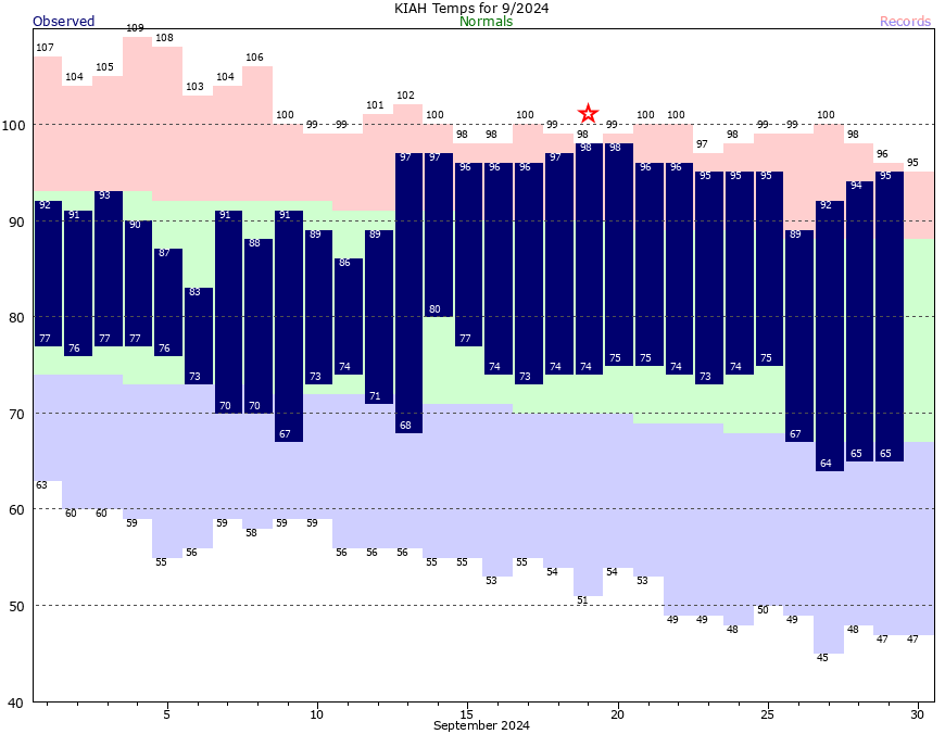
Fifteen of the last sixteen days in September have recorded high temperatures of 90 degrees or higher. (On the single day that did not, the high reached 89 degrees). This has occurred despite a front coming through a couple of days ago.
Why has the daytime heat persisted? Partly because our early fall fronts tend to bring drier air, but not much colder air. So our days remain warm because drier air heats up more efficiently. The primary benefit of the front, however, is that it has taken about 10 degrees out of nighttime temperatures, which has been nice.
Daily temperatures in September for Houston, compared to normals. (National Weather Service)
October is not going to bring immediate relief, but as our air modifies somewhat this week with higher humidity, we’ll see slightly cooler days by around Wednesday, and correspondingly warmer nights in the mid-70s. Later this month we can almost certainly count on more emphatic fronts to bring cooler daytime weather.
Monday
High temperatures today should, once again, reach the mid-90s for much of the metro area away from the coast (where highs will be a few degrees cooler). Skies will be sunny, with almost nary a cloud in the sky. Winds will be light, generally from the northeast. With dewpoints mostly in the 60s, the air won’t exactly feel dry, but it won’t be Houston-humid either. Lows tonight will drop into the low 70s for most locations.
Tuesday
A similar day to Monday, albeit with possibly a few more clouds in the sky.
Wednesday and Thursday
Expect more sunshine, with daytime highs generally in the low-90s, and nighttime temperatures in the mid-70s. Really, there’s not much more to say.
Friday, Saturday, and Sunday
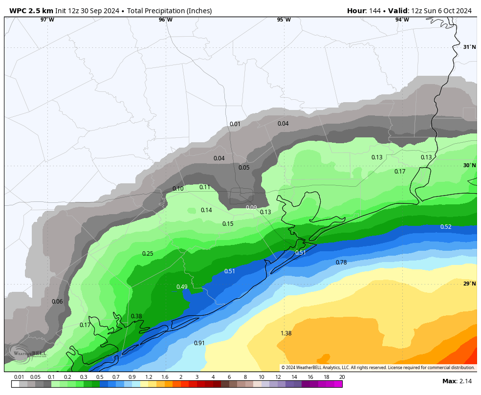
So there are a lot of fairly big events in Houston this weekend, and a lot of eyes on the weather. On Saturday there’s the Komen Houston Race for the Cure in Sam Houston Park, as well as the Southern Smoke Festival in Discovery Green. What I can tell you right now is a forecast for what will probably happen, but not a forecast for what will absolutely happen.
NOAA rain accumulation forecast for now through Saturday night. (Weather Bell)
Our atmospheric pattern will become somewhat more upset by Friday, opening the door to a few passing disturbances. Effectively, this means that we’re likely to see daily rain chances on the order of 20 to 30 percent during the Friday, Saturday, and Sunday period. Chances will be low- to non-existent for areas inland of Interstate 10, and at the higher end along the coast.
Friday and Saturday are likely to see partly sunny skies, whereas Sunday looks to be mostly sunny at this point. High temperatures will probably range from the upper-80s to lower-90s. The risk to the forecast is that the atmospheric disturbances are a little more pronounced than expected, leading to more widespread rain. But at this point the most likely outcome is a fairly warm, mostly rain-free early October weekend that feels more like late summer than early fall.
Next week
There is a fairly decent signal in the global models for a decent front to arrive on Monday or Tuesday of next week, but since I’m not yet certain on its passage I don’t want to give anyone false hopes. Needless to say, next week’s weather in Houston will be determined by whether said front makes it all the way through Houston.
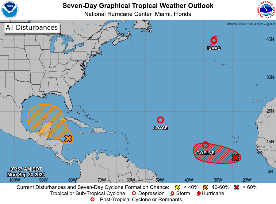
NOAA tropical outlook for Monday morning. (National Hurricane Center)
Tropics
We’ve had lots of questions about the tropical blob in forecast maps from the National Hurricane Center. Yes, we’re continuing to keep tabs on it. No, there still is not any indication that an organized tropical system is likely to directly impact the Texas coast over the next week or 10 days. For more information, check out our post from Sunday.
In brief: We are sharing a post we just published on our tropical companion site The Eyewall that talks about the next system expected in the Gulf this coming week. At present, we think it will likely stay east of Texas and is more a concern east of New Orleans to Florida. Still, we’ll watch it to be sure. We also have some links for folks that may want to help our neighbors in Appalachia that are dealing with an absolute catastrophe due to Helene.
Our thoughts are with folks impacted by Hurricane Helene. From what I have read and seen and heard about some parts of western North Carolina and Tennessee, it’s really, really bad. Worse than might be known at this point. Speaking as someone from Houston, which was has dealt with floods and then been flooded with resources after storms, these more rural communities are likely to be dealing with this for a long time and will need a *lot* of help in the weeks and months ahead, as the resources and media attention don’t always focus on places like that.
Keep in mind that after catastrophes like this, “stuff” is nice to donate but what is really needed is money. So consider that if you’re looking for ways to help. The United Way of North Carolina has a fund setup specific for Helene. Blue Ridge NPR has a nice list of organizations you can donate to as well. There is also the East Tennessee Foundation for folks there. Please post any other organizations in these areas in the comments.
As of late Sunday morning, there are still about 2.5 million customers without power from Florida to Ohio. This is down from a peak of around 4.5 million. It will take a long time to get to some areas in mountainous and rural western North Carolina and eastern Tennessee though, and some of these locations could be without power for weeks; the damage is just that complete in these areas.
Storm surge is the deadliest aspect of a landfalling hurricane, but inland flooding can dwarf that sometimes. We’ve seen it time and again in the last several years. If you live inland in the Southeast, Mid-Atlantic, or Northeast, you need to be prepared for hurricanes too.
There will be a lot more to discuss with Helene which we’ll save for another day. But suffice to say we have seen the worst-case scenario play out a lot more often in recent years. And this is going to be a big discussion point going forward both in how forecasts are communicated and how communities prepare for storms. You can’t rely just on the known lessons from past disasters anymore.
Forecast this week
The upper low and remnants of Helene will continue to produce generally light showers across the Midwest and East the next couple days before finally being ushered off to the east later this week. There will be pockets of steadier rain though, particularly in Virginia and West Virginia. Total rainfall over the next 5 days could add up to a couple inches there.
Rainfall through Thursday should be heaviest in Virginia and West Virginia as the broader storm containing Helene’s remnants slowly exits. (Pivotal Weather)
Localized flash flooding is possible today and tomorrow in the mountains there or Shenandoah Valley. These areas were not as severely impacts as areas to the south, but they remain vulnerable to localized flash flooding impacts.
Gulf & Caribbean: Something to watch
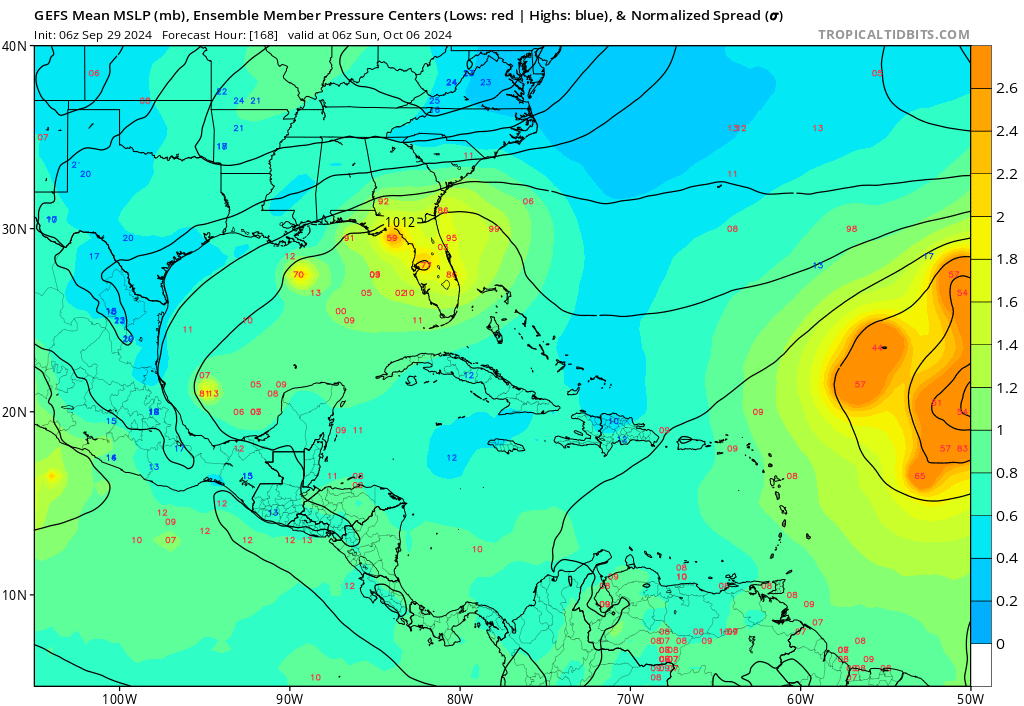
So what comes next? Unfortunately, the NHC now has a 50 percent chance of development somewhere between the Gulf and northwest Caribbean over the next 7 days.
A disturbance emerging from a Central American gyre type setup will carry a 50 percent chance of development this week in the Gulf or Caribbean. (NOAA NHC)
For our many readers in Texas, at this point, I would not expect this disturbance to come this far north and west. It will take at least the next 3 to 4 days to develop, and by the time it matures enough, it appears a cold front is headed toward the Gulf that will likely carry this back to the north and east. What this means for places from New Orleans through Florida is still a bit unclear. Modeling is sort of all over the place. At this point with Helene, we had basically two very distinct camps, one that buried the storm near the Yucatan and another (that got it right) carrying it north and northeast as a stronger storm. For this system, we have a similar sort of mixing of outcomes but there’s not exactly a distinct grouping of camps. In other words, there’s a good deal of uncertainty. The GFS ensembles are mixed, with some favoring a stronger storm headed back toward Florida and another group that ends up weaker. Some modeling doesn’t develop this at all. The ICON and European AI models generally show slower development and slow movement.
The GFS Ensemble from last night has some members carrying this disturbance toward Florida, a handful keeping it buried in the Gulf, and others still that never develop it. (Tropical Tidbits)
Given the uncertainty here, it’s important to continue to monitor this over the next couple days, especially in the eastern Gulf. But I will say that the more mixed nature of things in modeling makes me feel that a Helene redux is unlikely in this scenario. That said, keep watching. Impacts, assuming the system develops would likely occur next weekend.
Elsewhere in the Atlantic: Kirk to come
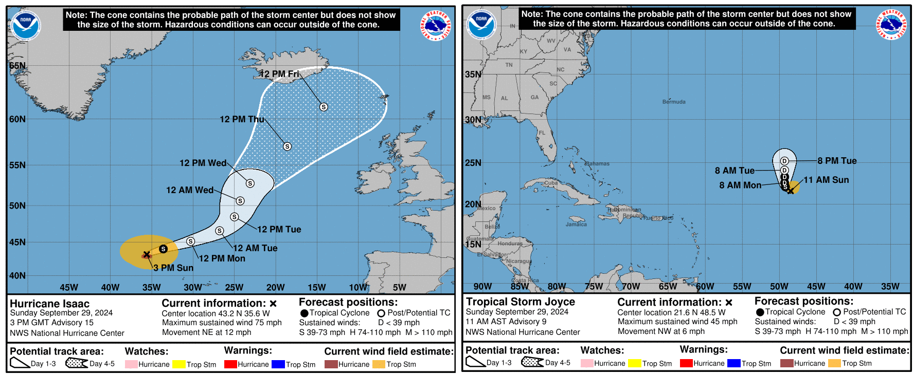
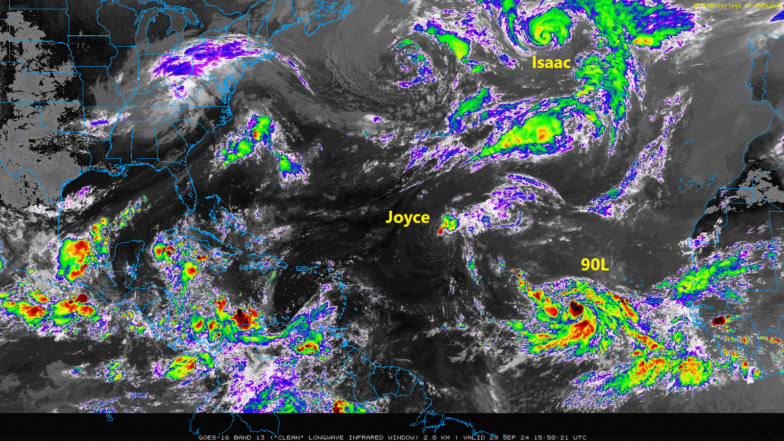
We currently have two active systems, Hurricane Isaac and Tropical Storm Joyce. Neither are direct threats to land.
Isaac and Joyce are likely headed toward dissipation soon. (NOAA NHC)
Both storms should lose tropical characteristics over the next 3 to 4 days and dissipate. Isaac will become part of a larger storm just north of the British Isles, as is periodically the case with North Atlantic storms.
Meanwhile, there are two additional areas to watch in the eastern Atlantic. First, there is Invest 90L, which looks like it’s ready to go off to the races. This one should turn northwest and north, generally following Joyce.
A busy Atlantic to close September. (College of DuPage)
The next name up is Kirk. Although this one is expected to go out to sea it’s worth keeping a side eye on for the Caribbean and Bermuda at least.
Behind 90L we look to have another disturbance in that cloud cover back off Africa. This is not expected to develop quickly meaning that it could come a bit farther west across the Atlantic. I might say that this one is more concerning in some aspects that what should become Kirk. If this can sneak west enough, it may find its own little environment to get going in. There’s not a ton of model support for this one either way, but interests in the Caribbean should at least keep an eye on it over the next 5 to 7 days as it comes west.
So over the next 7 to 10 days we likely have at least one more Atlantic storm and one more Caribbean or Gulf system. We may get a third storm in the Atlantic toward the end of that time horizon. Getting to (L)eslie or (M)ilton would put us at 12 or 13 storms for the season with a good 3 to 4 weeks of potential to go. Still far short of preseason expectations but somewhat less of an error. We’ll watch everything over the next couple weeks and keep you posted.
In the September Q&A, even though we think Texas’ hurricane season is in our rear-view mirror, many of the queries we tackle this month are hurricane related. Oh, except for the one about humidity and swimming pool water!
Got questions you’d like us to consider for next month? Reply in the comments below, or use the Contact link on the blog’s home page.
Q, As I get older, and having been through Ike and Beryl in Pearland, I’m becoming much less willing to endure another major storm so close to the coast. If a Cat 4 or 5 were to hit somewhere near Freeport or Galveston, would living somewhere like Magnolia or Katy really offer much more protection than Pearland? After Beryl, we drove to Dallas and saw downed trees all the way through Madisonville, about halfway there.
A. You know, I had similar thoughts as we rode out Beryl in League City. It was an unpleasant experience. (Personal note: I’m very much not a storm chaser. I appreciate the video and images they capture, but I like my storms far away, thank you). I used to think that I would stay in place for a Category 1 or Category 2 hurricane, but with the wildly swaying trees during Beryl, I’m not sure any more.
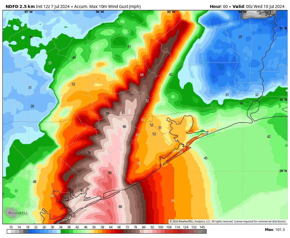
As for what you’ve asked, there is no question that Magnolia (especially) or Katy would on average be less susceptible to impacts from wind than areas closer to the coast, including Pearland. However, much depends on the strength of the hurricane, the angle at which it strikes the coast, and the speed at which it moves inland. Let’s look at a reasonably good wind gust forecast for Beryl:
Wind gust forecast for Beryl shortly before landfall. (Weather Bell)
This is not exactly what happened, but it’s pretty close, and it is illustrative of what I want to talk about. Specifically, note how important the track, and proximity to the core, is for the strongest winds. Whereas some areas of Galveston County near the water experienced gusts well below that of hurricane force, areas north of Montgomery County, including San Jacinto County, were vulnerable to hurricane force gusts. This is more than 100 miles from the coast.
The bottom line here is that there are a lot of variables. In general, however, the further you live from the coast, the lower the odds that you’ll experience significant wind damage from a hurricane. But that doesn’t mean the odds are zero.
– Eric
Q: (Are) there any historical trends or data to predict a ‘strong’ winter weather (e.g. extremely cold) based upon the low hurricane season activity relevant to Houston? As well as broader US implications? Given our weather patterns are tied together, highs dragging hurricanes and lows pushing them.
A: So the simple answer is no, there is no consistent way to use hurricane season as a gauge for the upcoming winter. We also hear a lot of people say “Well we had a hurricane, so we’re getting snow this winter!” Back in 2021, I wrote a section in our winter outlook, specifically for Houston that showed, historically, a hurricane strike on Houston doesn’t mean anything really and that the odds of snow in a normal winter were pretty much identical to the odds of snow in a post-hurricane winter.
But in a broader sense, a weather company (WDT, which I believe is now part of DTN) published a post a few years back to correlate Accumulated Cyclone Energy (ACE) to winter temps, which found nearly no correlation. The atmosphere is complicated and singular weather events like hurricanes, whether frequent or infrequent are unlikely to have an appreciable impact on an entire season’s worth of weather 3-4 months later.
I will say, there has been some work done to try to quantify this at a hemispheric scale, and there have been some results. A professor at Florida State has done good work on this. So I think there may be something we will eventually be able to gather from all this, but it’s unlikely to be due to one ocean basin’s activity.
– Matt
Q. Love your content. I’m curious, the models you cite [during hurricane coverage] sound like the same ones we’ve been using. Are AI models in development? I wonder if we can dump them all into AI and see what it thinks…
A1. This is the first year that we’ve really begun to use AI models as tools for hurricane forecasting. (If you’re curious how they work, compared to traditional physics-based models, I wrote a longer article here). We’re going to need to get to the end of the hurricane season to know precisely how well they worked. At that point there will be some comprehensive studies done to calculate how well AI-based models handled hurricane tracks in comparison to physics-based models. But my sense is that, for a new product, they’re surprisingly useful. They’re another tool in the arsenal that we look at every day. Matt may have some thoughts about this as well.
– Eric
A2: I will add that specifically for this year’s Gulf storms, the European AI model (the AIFS) has done astoundingly well. It has locked in early on and has tended to front-run the other model guidance in the right direction. In my day to day with it, I have also found it to occasionally have some skill in snuffing out risks to the forecast, such as a cooldown in mid-summer. Perfect? No. Useful? I believe so. The AI suite will get a good test this winter of how reliable they are at picking out cold snaps or snowstorm risks in the Midwest/Northeast. But they are firmly in my toolkit daily now. –
–Matt
Q: This may have an obvious, easy answer but why am I constantly filling up the pool in the hot HUMID summer? I would figure dry air would sop up pool water (moisture) quickly but not so much air already saturated with water.
A: This is an interesting question, and your assumption is correct: More humid air tends to reduce evaporation of water in a pool. So the question then becomes, what’s going on?
One possible reason could be exposure to sun. If it’s in a lot of sun with limited tree coverage, even in high humidity, you’ll still deal with evaporation. Another possible explanation could be the very dry stretch we went through in August. The spigot shut off for an extended time, which probably didn’t help. Beyond those two explanations, there may be something else afoot! Probably something to monitor for pool maintenance folks, just in case!
–Matt
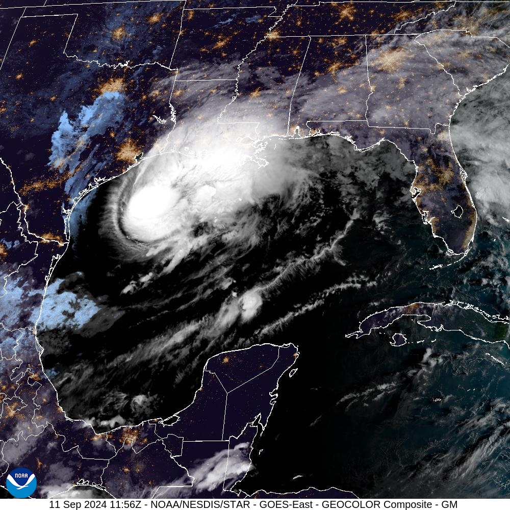
Hurricane Francine as approached the northern Gulf Coast on Sept. 11. (NOAA)
Q. I’ve noticed that many major hurricanes in the Gulf of Mexico during September and October tend to impact Louisiana and Florida more than Texas. I’m curious about the reasons behind this pattern. For example, does it have anything to do with the position of the Bermuda High or seasonal changes in weather patterns? Additionally, is it common for hurricanes to stop hitting Texas after mid-September, or are there historical exceptions?
A. I noticed this phenomenon nearly 20 years ago, and did a little research to figure out that after the date of September 24 the historical odds of a hurricane striking the state of Texas are about 1-in-50. So every year, around this date, I write something to the extent that the Texas hurricane season is pretty much over. (Here’s this year’s post). At some point I’ll probably be embarrassingly wrong about this, but generally, if we get to September 24 and things look quiet, it’s a fairly safe bet that we’re done with the threat of hurricanes. And I am talking about hurricanes—the odds of a tropical storm or depression are higher.
There are sound reasons why this is. Generally, as we get toward the end of September, the upper air pattern starts to change as the jet stream begins to move southward. This provides a generally eastward steering flow that we don’t see in August or earlier in September. A good indicator of this is when we start to get our first cool fronts (we’ve already had two this month). The big risk here, of course, is that the Caribbean Sea and Gulf of Mexico are still plenty warm in October to support hurricanes, so the threat is there. It’s just that, meteorologically speaking, it’s difficult for these storms to track westward into Texas. That’s not a taunt, mind you.
In brief: After more than four months, Houston’s overnight temperature has once again reached 65 degrees, which we consider the threshold for a fall-like night in the city. Accordingly, we’re celebrating Fall Day today! Houston’s temperatures will warm up quickly, but our air will remain dry through the weekend. Rain chances are near zero for at least the next five days.
Yes, it’s Fall Day
The first half of this summer was moderate, temperature-wise. But some of this ‘cooler’ weather was driven by Hurricane Beryl, which uprooted many trees and led to a prolonged, widespread power outages. Then, for much of August (remember that stretch of seven straight 100-degree days?) and September, Houston has experienced warmer than normal conditions. So yes, we’re due for a break.
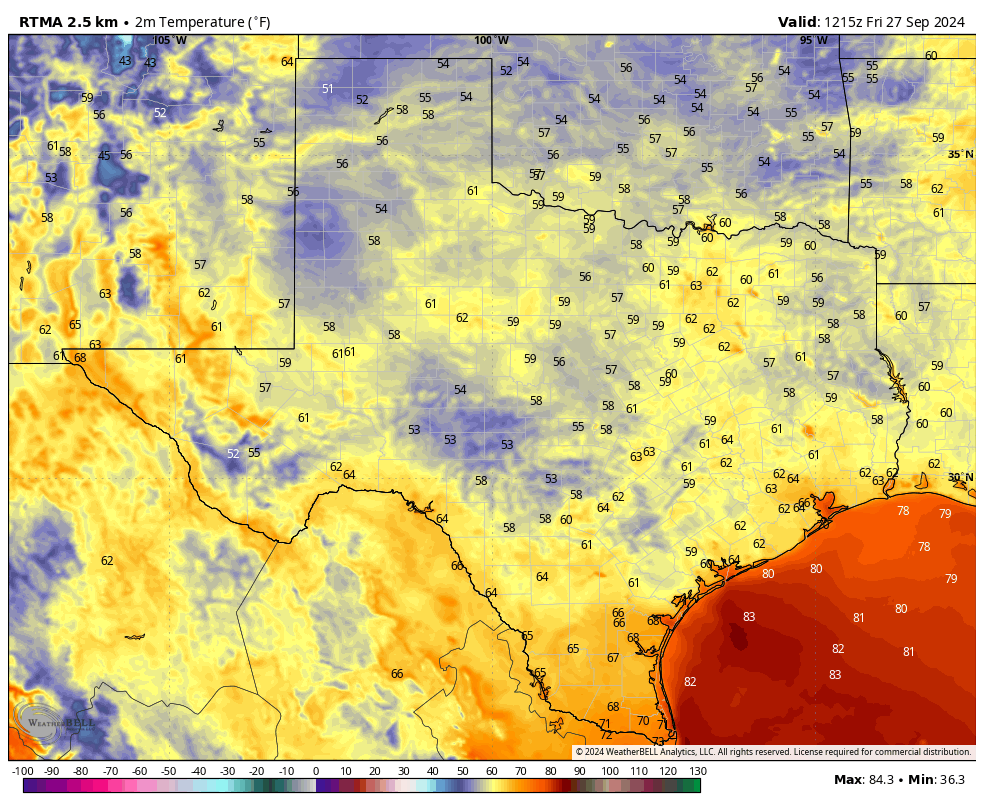
Much of Texas is experiencing a fall-like morning. (Weather Bell)
That came this week, in the form of our region’s second front. Low temperatures at Bush Intercontinental Airport fell to 64 degrees this morning, the first time since May 18 that the city has recorded a low of 65 degrees or below. We therefore decree today to be Fall Day in Houston, and I hope you take a moment to celebrate it outside. No, the weather isn’t going to be particularly cool. But the air will feel much drier than is typical during summer in Houston.
Friday
For a few hours this afternoon it won’t feel much like fall, as much of Houston is likely to climb into the upper 80s or even reach 90 degrees. But with dewpoints dropping into the lower 50s, the air will feel fine. Winds will be from the north-northwest at 5 to 10 mph, and skies will be clear. Low temperatures tonight will likely be a degree or two warmer than Thursday night, dropping into the upper 60s for most locations in Houston, with slightly cooler weather outside the city.
Saturday and Sunday
Expect sunny skies and warm days, with high temperatures in the low- to mid-90s. However, moderately drier air will take some of the sting out of the heat, and with lower humidity mornings and evenings will be pleasant. Expect low temperatures to drop to around 70 degrees. Rain chances are approximately zero percent.
Next week
Sunshine and warmth prevails through the first half of the week, with daytime highs generally in the mid-90s. This is pretty warm for late September and early October, but it’s being fueled partly by slightly drier air than normal. So while it will be hot, I wouldn’t characterize conditions as sweltering. Nighttime lows drop into the low 70s.
During the second half of the week we probably will see the onset of some more clouds, and some modest rain chances return to the forecast. At some point, perhaps over the weekend, another front will make a run at pushing all the way to the coast. I don’t have enough confidence in the forecast to predict when, but at some point within 7 to 10 days from now I’d expect cooler weather to return. We’ll see.
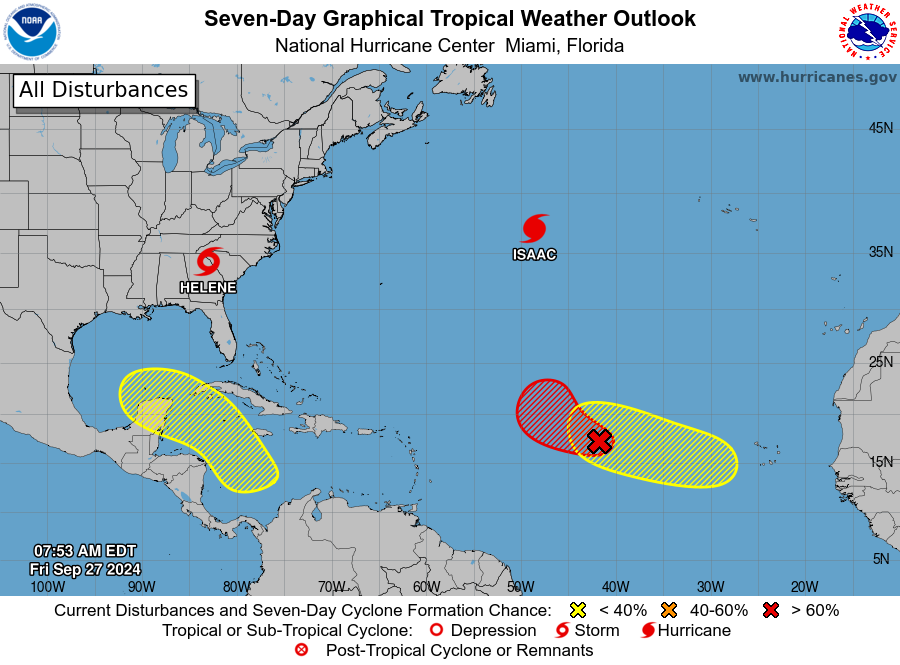
Tropical outlook for Friday morning. (National Hurricane Center)
Tropics
After making landfall on Thursday night in northern Florida, Helene has pushed well inland and is now ravaging the southeastern United States with heavy rain and gusty winds. It’s creating an awful mess. As we look deeper into the tropics, the National Hurricane Center is calling attention to an area of low pressure in the southern Caribbean Sea that could eventually develop into a tropical storm. This is something we will, of course, be watching. However, there is no real indication at this point that an organized system is ultimately going to track toward the Texas coast.