Hit and miss showers for Friday followed by a much cooler, drier weekend

Summary: A couple rounds of shower chances exist today, this morning and later this afternoon. Many folks won’t see much meaningful rain though. Showers clear this evening with much cooler and drier weather for the weekend. Temps warm back up next week with rain chances returning for the second half of the week.

Before we begin today, Eric and I want to say “Howdy!” to Nyree Doucette’s 4th grade students at Sinclair Elementary. They have been using our forecasts to help plan for their Rodeo Day today, hoping for no rain. It’s been a real close call all week it seems, and unfortunately, it’s not any less close today as you’ll see below. Whatever happens, thank you for reading our forecast, hopefully you can learn something, and we really hope your Rodeo Day goes off and is fantastic!

Today

So, we saw a few more showers than perhaps we expected yesterday evening, which creates a slight conundrum in our forecast for today. Based on everything I’ve been able to digest this morning, I think there are two general phases to today’s rain chances. The first phase is this morning. Sorry to Ms. Doucette’s 4th graders.

The HRRR model depiction of how showers should progress today. Notice that not everyone sees them and the highest concentration is north and northeast of Houston. (Pivotal Weather)

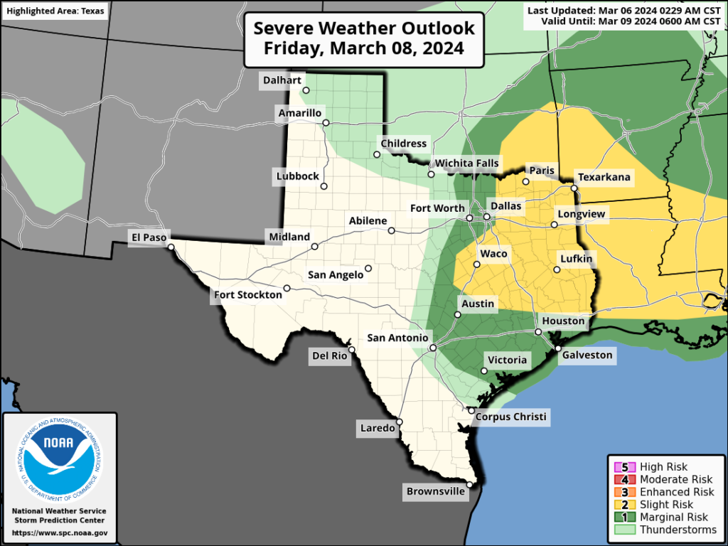
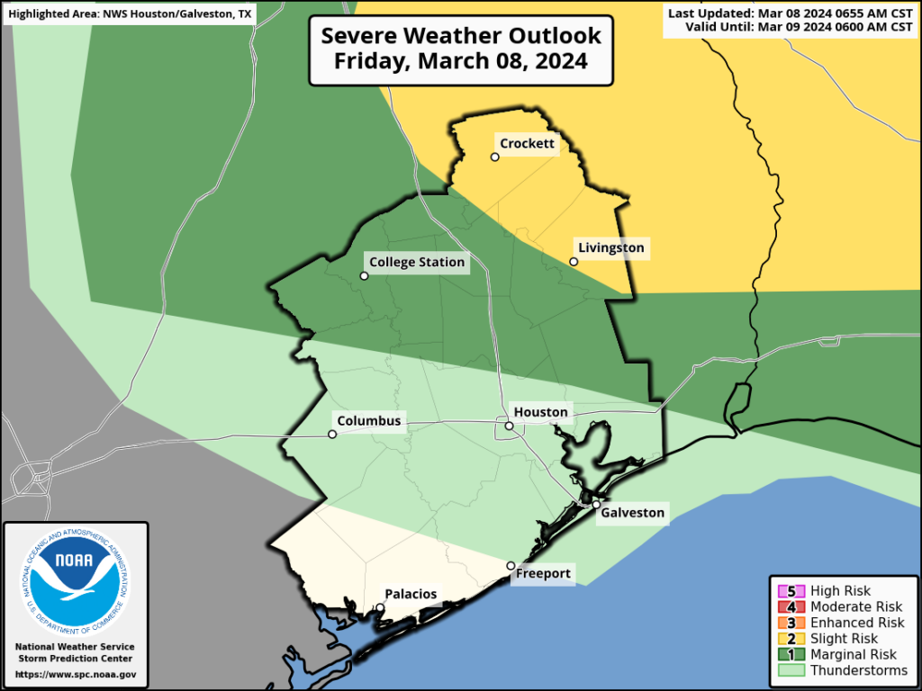
That doesn’t mean the morning will be a total washout! But it does mean that we should see scattered showers around the region. I would not entirely rule out a rumble of thunder, but that should be the exception, not the rule this morning. Not everyone will see rain but those that do could briefly see some heavier downpours. I would assume the afternoon is partly sunny with some stray showers or a thunderstorm around. No severe weather is expected in Houston or points south at this time, but the chance for an isolated strong or severe storm increases as you go north of Harris County. Folks in the Piney Woods up through Shreveport may see some decent hailers today.

Severe weather risk today is mainly well north of Houston, with a slight risk (level 2/5) up toward Lake Livingston and Crockett. (NOAA SPC)

Other than that, highs today should manage our fifth consecutive day of 80 or better.

The second chance at some storms comes late this afternoon or this evening. Read on.

Rodeo Forecast

These storms should be even more isolated and less pronounced than anything earlier in the day, but one or two rogue thunderstorms could pop up in the area this evening with the actual cold front as you’re making your way to Houston Livestock Show & Rodeo. It’s Major Lazer night, so we don’t want to throw any cold water on your anticipation, but just don’t be shocked if there’s a brief 10 to 20 minute shower. Otherwise, the front should begin to push across the area in the evening, sending temperatures from to mid to upper-70s as you arrive to the upper 60s as you leave. There could be a bit of a breeze on the way out with noticeably lower humidity.

We’ll eventually see temperatures drop all the way into the mid-50s by Saturday morning.

Weekend

The weekend looks fine, albeit a bit on the cool side. Expect to see clouds giving way to some sun through the day Saturday and perhaps again on Sunday. Along with a breeze, temperatures will be in the mid-60s Saturday afternoon and the mid to upper-60s on Sunday with less wind.

Sunday morning should see lows in the 40s everywhere except the immediate coast. (Pivotal Weather)

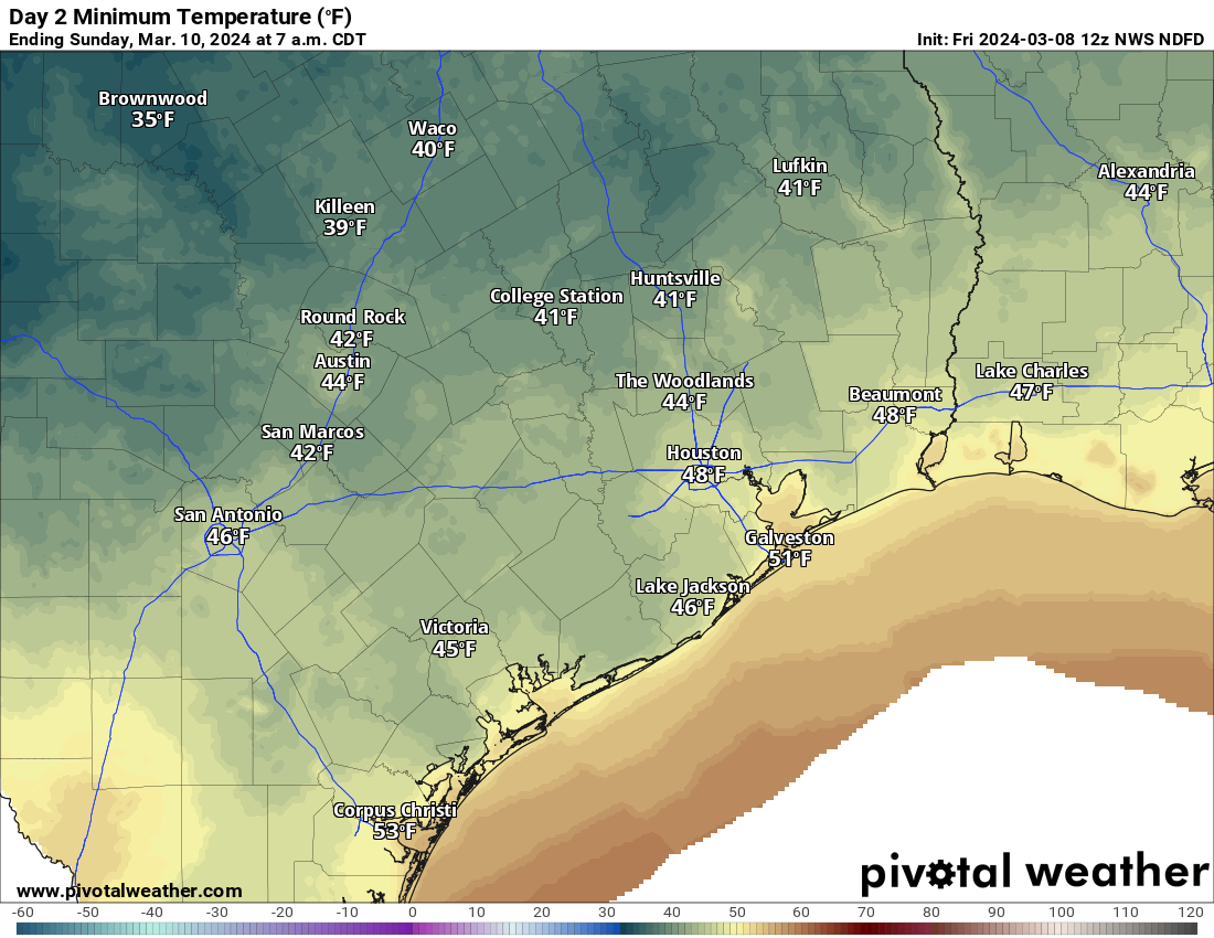
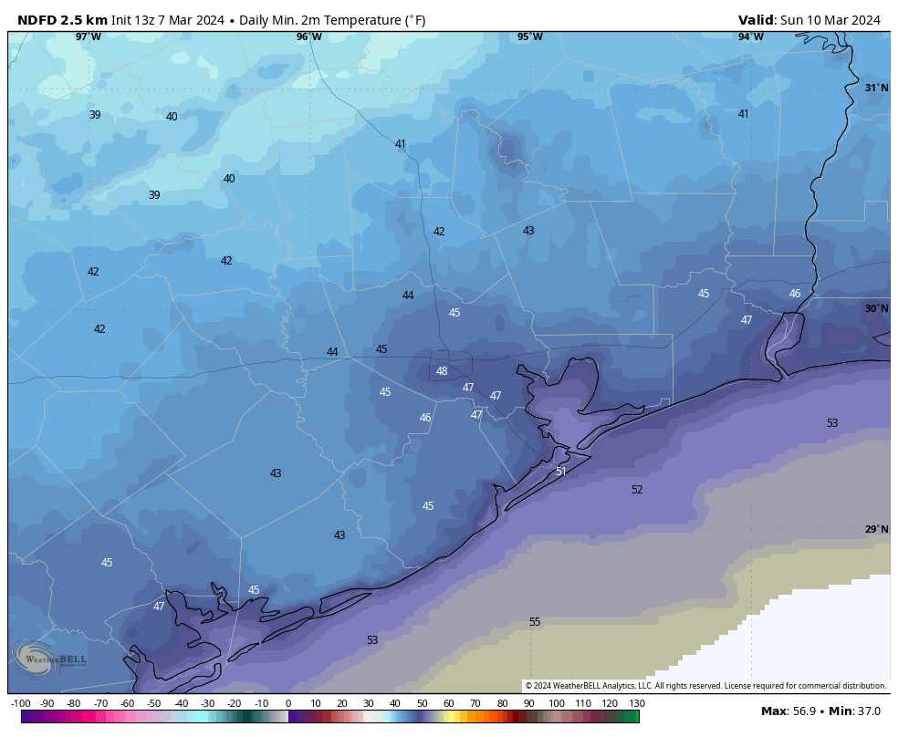
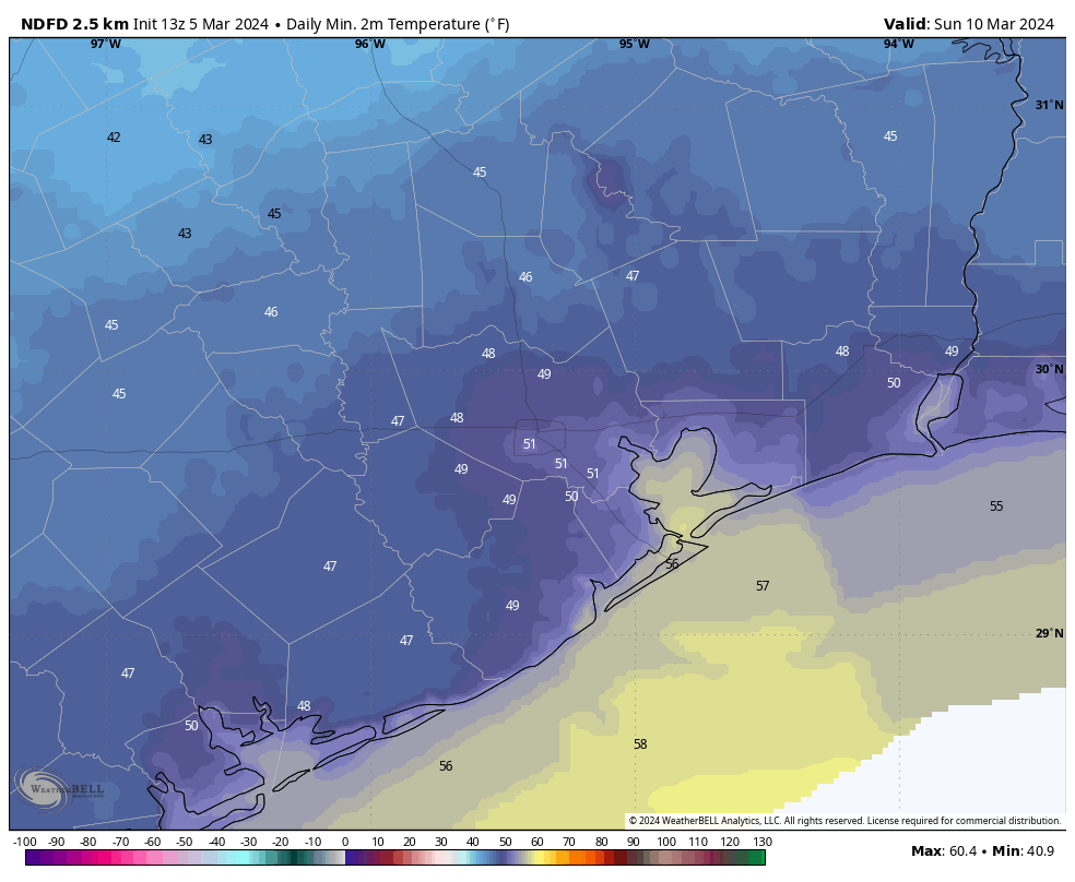
Sunday morning will be a cool one, with lows generally in the 40s across the region!

Next week

Monday looks great with sunshine and highs back into the 70s. Morning lows should be near 50 degrees. Tuesday should see a few more clouds with morning lows in the 50s and highs in the middle or upper-70s.

By the time we get to Wednesday, a few showers will be possible, with a better chance Thursday and/or Friday. Details remain to be seen, but we still could be looking at some scattered downpours and thunder in that time. Highs will be in the 70s or 80s with some humidity and lows in the 60s.

After some uncertainty Friday, a lovely weekend awaits for Houston

Summary: Houston will see a couple of warmer days to end the work week, with the possibility of some showers on Friday, ahead of what should be a stellar weekend with some chilly nights. Sunday, especially, looks really nice with plenty of dry air and light winds. Enjoy!

Forecast for maximum wind gusts through Thursday evening. (Weather Bell)

Thursday

Today will bring partly sunny skies, and this increase in cloud cover should help to limit high temperatures to the upper 70s to 80 degrees. However, in a change from Wednesday—which ended up being a rather pleasant day outside—winds from the southeast will be more pronounced, gusting at times up to 25 mph. This influx of southerly air will pump up humidity levels a bit this afternoon and evening.

Rodeo forecast

We’ll continue to see occasionally gusty winds this evening, but temperatures will remain mild, in the low 70s on the way into the show. I can’t entirely rule out a stray shower this evening before or after the show, but chances are low, likely on the order of 10 percent or so. Lows tonight are only going to drop into the upper 60s, with plenty of humidity. So probably a bad hair night.

Friday

I’m still not particularly confident in the forecast for Friday. The most likely scenario is that a capping inversion holds out, and this prevents the widespread development of thunderstorms in the Houston metro area. In this case, we’d see scattered to widespread light showers during the morning and possibly early afternoon hours, with only slight accumulations. However there is a possibility that the cap breaks, allowing the very moist air at the surface to rise, and yielding the potential for severe weather. I think that chance is low, probably 10 or 20 percent, but it is non-zero. Otherwise, it’s going to be a warm and muggy day to start. Eventually we’re going to see drier air from a front. In terms of timing, I’d guess the front will reach areas such as Katy and The Woodlands on Friday afternoon-ish, and push off the coast by around midnight.

Saturday

We’re likely to start off with cloudy skies on Saturday before the sky starts to clear some during the afternoon hours. Highs will likely peak in the mid- to upper-60s, and we’re going to see breezy conditions during the afternoon hours, with gusts up 25 to perhaps even 30 mph from the north. Lows on Saturday night will likely drop into the upper 40s.

Sunday morning looks fairly chilly. (Weather Bell)

Sunday

This should be a pleasant day with dry air in place, highs in the upper 60s, and partly sunny skies. Lows on Sunday night will again drop into the mid- to upper-40s in Houston with colder conditions inland.

Next week

We’re going to see a warming trend, with days in the 70s, and then possibly about 80 degrees, toward the end of next week. There also is a solid signal for some rain showers on Thursday and Friday ahead of the next front. Perhaps we’ll see 1 to 2 inches of rain? Hard to say at this point.

Houston blasts record high on Tuesday, but now will cool down a bit

Summary: After record heat on Tuesday, Houston will cool off slightly today and Thursday. Rain chances return Friday, with the slight potential for some thunderstorms. The weekend looks rather pleasant, with a fair amount of sunshine and highs in the 60s.

Early season heat

Houston fell just short of 90 degrees on Tuesday, with a high temperature topping out at 89 degrees at Bush Intercontinental Airport. This smashed the previous record high for March 5, 84 degrees, which was reached in 1907, 1991, and 1998. The normal high for this time of year is 72 degrees.

If you’re wondering whether this would have been the earliest 90-degree day on record in Houston, had the mercury ticked a single degree higher, the answer is no. The city’s earliest 90-degree day in a calendar year came on February 20, 1986, with a high of 91 degrees.

Temperatures from Texas to Canada were 15 to 30 degrees above normal on Tuesday. (Weather Bell)

What does all of this mean for the rest of spring and summer? As it’s a single data point, probably not a whole lot. But with a waning El Nino we already were expecting warmer than normal conditions through the middle of this year. So if nothing else, it’s a preview of what is to come. But fortunately, not just yet.

Wednesday

A few more clouds today should help to cool temperatures a bit, with highs likely in the low- to mid-80s. Winds from the southeast will be light, at 5 to 10 mph. With dewpoints around 60 degrees the air will be modestly humid, but nothing too crazy.

Rodeo forecast

Once again there should be no weather concerns about attending the Houston Livestock Show & Rodeo this evening. Temperatures going in to the show will be in the low 70s with partly cloudy skies. Afterward they’ll be in the upper 60s, so very mild. Rain chances are nil. Overnight lows will drop into the low 60s in Houston, with the possible development of fog near the coast.

Thursday

This will be a mostly cloudy day with a high of around 80 degrees. We’ll also see a more robust southerly wind at the surface, at times gusting to 20 or 25 mph. There is a slight chance of some very light showers later on Thursday afternoon, evening, and overnight, with lows likely only dropping into the upper 60s.

Friday

I have lots of questions about Friday, but only some general answers at this point. In the big picture, an upper-level low pressure system will shove a front toward our area, and this will help provide the impetus for some rain showers. What I think will happen is that beginning early Friday morning and running through the early afternoon, we’ll see some mostly light showers progressing from west to east across the area. I don’t think accumulations will be too great, likely on the order of a few tenths of an inch of rain. With that said, there is a chance that we see some stronger thunderstorms embedded within these showers. Again, I think the likelihood of this happening is low, but it’s non-negligible. Chances are better for thunderstorms to the north of the Houston metro area.

Severe weather outlook for Friday. (NOAA)

In terms of temperatures we’ll see highs, probably, in the upper 70s. Drier air will arrive with the front during the afternoon or evening hours, pushing overnight lows into the 50s.

Saturday and Sunday

The weekend will see the return of mostly sunny skies, for the most part. Saturday will be breezy, as drier and cooler air blows in. Look for highs in the upper 60s, with lows dropping on Saturday night to around 50 degrees in the city, with cooler conditions further inland.

Sunday should be a fine, partly sunny day with highs in the mid- to upper-60s and lighter winds. Lows Sunday night again drop to around 50 degrees.

Next week

Most of next week should bring highs in the 70s, with a mix of clouds and sunshine. It continues to look like we’ll see a decent shot of rainfall during the Thursday and Friday time period ahead of another front, but the contours of all that remain pretty hazy.

Sure signs of Spring: Mosquito hawks, June bugs, and pollen

Summary: We’re seeing the return of Spring not just in weather, but nature, with a profusion of bugs. Temperatures in the days ahead will do little to deter them, with highs in the 80s for the work week before we cool off a bit this weekend. We could see some showers on Friday ahead of a front.

The bugs are back, baby

February was rather mild across the Houston area, with an average temperature about 4 degrees warmer than normal. March has started more or less the same, and with temperatures today in the mid- to upper-80s it will definitely feel like winter is an afterthought. As one walks around outside there are other signs as well. The mosquito hawks, large and harmless flying insects, are thick as thieves in my neighborhood. (Their formal name is crane fly, by the way). And at night it sounds like the June bugs are popping like popcorn has they hit the window. Tree pollen numbers are rising. Pretty soon, I have no doubt, we’ll see increasing mosquito activity.

Anyone else seeing lots of mosquito hawks? (RidhaAnshari85)

Looking ahead to the forecast it seems pretty clear that Spring is here to stay. Our next two fronts, this weekend and next weekend, roughly, will knock low temperatures down into the 40s for a few days. But there are no signs on the horizon of any really strong or prolonged cold snaps. So in this case nature is not lying. Spring has sprung, and the bugs are back.

Tuesday

Coastal counties are seeing fog this morning, but it will burn off by mid-morning at the latest. In its wake, later today, we should see mostly sunny skies. This sunshine, along with some slightly drier air, will allow highs to pop up into the mid- to upper-80s today—possibly our warmest day of 2024 so far. This daytime heating and an atmosphere that is slightly disturbed may lead to some highly isolated thunderstorms later this morning, and during the afternoon hours, but I’d put chances of that at about 10 percent. Mostly, it will be warm and sunny.

Rodeo weather

There should be no concerns about attending the rodeo this evening. Temperatures will be mild, in the 70s, with light winds and partly to mostly clear skies. Post-show temperatures will still be in the upper-60s, so not really a chill in the air. Overnight lows will drop into the mid-60s, with a potential for returning fog by early Wednesday morning.

Wednesday

Wednesday will be warm and mostly sunny again, with highs likely reaching the low- to mid-80s. Lows again will only drop into the 60s.

Thursday

A cloudier pattern sets in on Thursday, and this should limit highs to the upper 70s to 80 degrees.

Friday

Atmospheric moisture will surge on Friday, leading to a more humid day and a decent chance of rain ahead of the next front. For areas north of Houston, such as Conroe and Huntsville, it looks like the atmosphere will support the possibility of stronger thunderstorms. However closer to downtown Houston and the coast, we should see a weakening trend in the intensity of rainfall. Overall, I’d expect accumulations of between a few tenths of an inch and 0.5 inch, with about a 50 percent chance of rain. The best chances will come during the morning hours.

Highs Friday will be in the upper 70s, with mostly cloudy skies. A front will arrive, but not until the afternoon or evening hours most likely. Lows on Friday night should drop into the 50s.

Low temperatures on Sunday will bring some chill back into the area. (Weather Bell)

Saturday and Sunday

The weekend looks pleasant, with highs in the upper 60s to 70 degrees and mostly sunny skies. Saturday does look breezy, with gusts above 20 mph as drier air moves in. Winds die down overnight. Lows will be in the upper 40s to 50 degrees—so cool, but not exactly cold.

Next week

Most of next week should bring temperatures in the 70s. Of note is the possibility for some decent rainfall accumulations toward the middle to end of next week. After a wet winter it’s been fairly dry of late, so an inch or so would not be unwelcome. Eventually some sort of front should cool us back down, at least a bit, for the following weekend.